Utica, New York

It’s been a big weather week in the southern US, and all that activity is moving the north-northeast. At least Utica is accustomed to big snow, in case that is what is on the way.

At 153PM, ET, Utica was reporting a temperature of 25 degrees with overcast skies. The low pressure that has been bringing so much pain and heart break to the southern US has shifted predominantly off shore, but an inverted trough is pointed through New Jersey towards Binghamton. Light snow was falling across the Poconos and was headed towards Utica.
Snow will continue in the area as low pressure becomes distended perpendicularly across the Gulf Stream. The cold front will stall, and so too will the inverted trough across New York. Light snow showers are going to continue in Utica at least through the day tomorrow as reorganization begins in the southeastern US. Troughing will be tilted aloft, which will be conducive to further cyclogenesis. The reborn feature will get stronger tomorrow night into Saturday morning. The feature will shift into the North Atlantic and drag wet weather along with it. Late Saturday will be cool but dry.
Tomorrow – Snow likely all day, High 30, Low 19
Saturday – Some early snow, then clearing and cold, High 26, Low 17

TWC: Tomorrow – Variable clouds with snow showers High 32, Low 21
Saturday – Overcast. A few flurries or snow showers possible. High 27, Low 19

AW: Tomorrow – Periods of snow, accumulating 1-3 inches; storm total snowfall 3-6 inches High 33, Low 24
Saturday – Remaining cloudy and breezy with a couple of flurries High 30, Low 24

NWS: Tomorrow – Periods of snow, mainly before 1pm, then scattered snow showers after 2pm High 32, Low 20
Saturday – A chance of snow showers. Mostly cloudy High 27, Low 18

WB: Tomorrow – Snow. Total snow accumulation of 2 to 4 inches. High 32, Low 22
Saturday – Mostly cloudy with a 50 percent chance of snow showers. High 28, Low 22

WN: Tomorrow – Cloudy with light snow likely, High 32, Low 20
Saturday – Mostly cloudy with chance of light snow showers, High 27, Low 18

FIO: Tomorrow – Foggy throughout the day. High 35, Low 22
Saturday – Foggy overnight and in the morning. High 28, Low 18

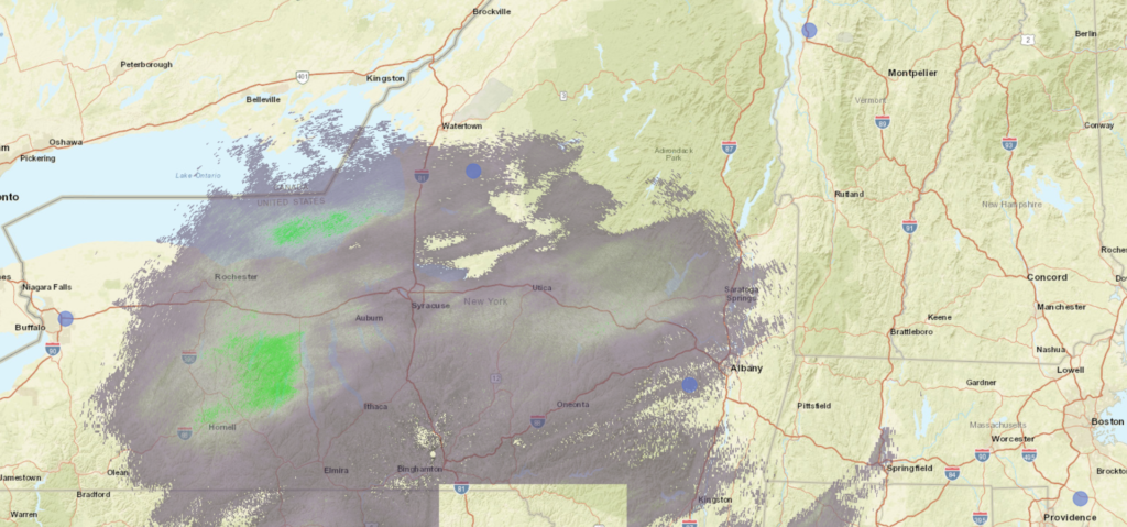
It’s going to be a smattering of snow across the region, which will last for quite a while, and thankfully not a big storm like they saw in the south, or really like they can see with a lake effect feature. Here is the radar right now, with a lot of coverage, but not much heavy precipitation.

Is relief in sight?

Snow is inconvenient, challenging and dangerous, while the ice being seen from Mississippi to New Jersey is destructive, but the enduring cold is proving the most difficult and costly disaster, particularly in Texas. Power grids are failing thanks to a lack of winterization amid a cold snap that is breaking record books across the Plains (for example, Oklahoma City saw the coldest temperature recorded since before Oklahoma was even a state).

As you can see with the first image, the cold spell will alleviate over the course of the next week. With this particular situation with people freezing in their homes, it’s important to get a little more clarity. It’s nice to know that things will be more comfortable next week, but we still need to get to next week.

Cold weather, though not record breaking, will continue through the day tomorrow before things begin to really alleviate. Temperatures on Friday will remain cold, but temperatures in the afternoon from Oklahoma to Arkansas and southward will start to pop into the 40s, slowed somewhat by all the snow that has fallen.

Temperatures will hit the 50s around Abilene, and the 40s over the Metroplex on Saturday, with above freezing temperatures reaching into Iowa on Sunday. By early next week, 60s will be widespread, with a forecast in the mid 80s for Abilene by next Thursday.

Relief is on its way, and with spring coming up, it seems unlikely that we will revert back to another icy blast again. At least, not this winter.

Dubuque, Iowa

We’re headed to the northern US tonight to see what catastrophe is happing up there. Catastrophes everywhere.

At 1153PM, ET, Dubuque was reporting clear skies and a temperature of -8. Dubuque was smack dab within the upper level trough responsible for the wild weather in the south, and the cold weather in the Plains. A feature tolling along the base of the trough is going to trigger change across the nation.
An inverted rough will be directed to the north from the advancing low in the Lower Mississippi Valley, and will pass over eastern Iowa through the day Wednesday. There won’t be a lot of moisture available to this disturbance, but with temperatures as cold as they are, big, dendritic flurries are more than possible. As the feature propagates, it will elongate, and circulation will become distorted. With less northerly flow, Thursday looks to be the first day of a true warming trajectory.
Tomorrow – Flurries, High 12, Low -10
Thursday – Warmer and partly cloudy, High 17, Low 2

TWC: Tomorrow- Partly cloudy skies during the morning hours will become overcast in the afternoon High 17, Low -9
Thursday – Partly cloudy skies. High 22, Low 1

AW: Tomorrow – Some sun, then turning cloudy and cold; a little snow this afternoon with little or no accumulation High 15, Low -5
Thursday – Cold with intervals of clouds and sunshine High 21, Low 2

NWS: Tomorrow – A 30 percent chance of snow, mainly after 2pm. Patchy fog before 8am High 14, Low -12
Thursday – Mostly sunny, High 21, Low 3

WB: Tomorrow – Mostly cloudy. Patchy fog in the morning. A 40 percent chance of light snow in the afternoon, High 13, Low -6
Thursday – Mostly sunny, High 18, Low 2

WN: Mostly cloudy, High 14, Low -12
Thursday – Partly cloudy, High 21, Low 3

FIO: Tomorrow -Overcast throughout the day. High 17, Low -11
Thursday – Foggy until morning, starting again in the evening. High 23, Low 4

Clear night in Dubuque. Brr. But at least good news is on the way.

Hattiesburg, Mississippi

Hattiesburg is among the many, many cities nation wide that is experiencing cold that they are wholly unaccustomed to. Particularly in the southern United States, record cold on top of a huge winter storm is working to exasperate the situation. Lets see if there is any hope for improvement for these next couple days.

At 653PM, CT, Hattiesburg was reporting cloud skies and a temperature of 23 degrees. The deep, strong, broad trough across the country is still holding firm to it’s place over the Plains. Another round of snow and ice is currently falling over the Red River Valley, getting ready to shift into a more moisture rich environment to the east.
The wet weather will arrive in Mississippi towards afternoon tomorrow. The freezing line right now looks to slice just to the north of town, while enough warm air is expected to be drawn north to keep Hattiesburg in the rain overnight Wednesday into Thursday morning, though an ice storm is anticipated across the rest of Mississippi. The wavelength of the jet trough will contract after the storm has pushed to the east, and cold air will be able to dig south, leading to a chilly end of the week in Hattiesburg, but with the promise of some warmth soon after.
Tomorrow – Rain, sometimes heavy and embedded with thunder late in the day. High 46, Low 20
Thursday – Rain early, then clearing and chilly, High 45, Low 33

TWC: Tomorrow – Partly cloudy in the morning then becoming cloudy with periods of rain later in the day. High 46, Low 21
Thursday – Showers in the morning, then cloudy in the afternoon. High 44, Low 37

AW: Tomorrow – Mostly cloudy and cold; a passing shower in the afternoon High 47, Low 19
Thursday – Occasional rain and drizzle in the morning; otherwise, mostly cloudy and cold High 42, Low 35

NWS: Tomorrow – Showers likely and possibly a thunderstorm, mainly after 4pm. Mostly cloudy, High 44, Low 23
Thursday – Rain and thunderstorms likely before 1pm, then a chance of rain. Cloudy, High 47, Low 36

WB: Tomorrow – Showers likely, and a chance of thunderstorms in the afternoon. Mostly cloudy. High 45, Low 20
Thursday – Light rain and thunderstorms likely in the morning then a chance of light rain in the afternoon. Cloudy. High 42, Low 36

WN: Tomorrow – Mostly cloudy with showers likely, High 44, Low 23
Thursday – Mostly cloudy with thunderstorms likely, High 47, Low 36

FIO: Tomorrow – Rain until night, starting again in the afternoon, High 46, Low 24
Thursday – Rain overnight and in the morning, High 49, Low 32

I’m not so sure about the threat for thunder. The system has a lot of juice, but I’m not sure there is enough instability in the region. Still, there is going to be a healthy dousing of rain, perhaps over a half inch. If that all freezes on contact to the north, it could be a scary situation from Jackson north towards Memphis and Tupelo. This is a big time system. Here is the next round of wet weather on satellite over the Red River Valley.

NOAA/NESDIS/STAR GOES ABI BAND 14 OR_ABI-L1b-RadC-M6C14_G16_s20210480131035_e20210480133407_c20210480133535.nc

Winter is crushing the United States right now

If you live pretty much anywhere in the continental United States, the story leading the local news probably revolves around the hellish winter conditions in your area. What you might not fully appreciate is that it’s rough everywhere in the country, save, perhaps, for the desert Southwest, though even there, there are some winter weather advisories around the 4 Corners.

In the Pacific Northwest, a large system brought significant snowfall not only to the Cascades, but closer to the coast, where Seattle was even placed in the grips of heavy wet snow before things could finally turn to rain yesterday. The storm has lost a lot of it’s organizational structure at the surface, but it continues to bring snow to the mountains of the northern and central Rockies.

Eventually, this system will be the feature praised for breaking the vicious cold snap that has been keeping everyone indoors and by the fire across the Plains. Record breaking cold has come to the far northern Plains, but also subzero temperatures are sinking as far south as Oklahoma. A wind chill advisory was issued for the Houston for the first time ever.

If you are in Houston, however, the cold is only part of the problem. East Texas remains in a winter storm warning, and are also seeing temperatures much colder than they are accustomed to, including parts of the state that are 50-60 degrees colder than normal. Snow and freezing rain blasted the state this weekend, with places as far south as Austin receiving half a foot of snow, and Brownsville and Harlingen seeing a dusting of snow.

A huge part of the issue, however, is the burden on energy in Texas. There are infrastructural issues with preserving power systems in the cold, there are also functional problems. Texas doesn’t rely on natural gas for heat like a lot of places in the north, with many houses not even having furnaces. As a result, the electrical grid is overwhelmed by the widespread use of space heaters, and millions of Texans are out of power.

Now, the system, as you might be able to discern from the warnings at the top of the page, is heading to the northeast, where it will be enhanced by the Great Lakes from Indiana to New England, but where the storm will really be dangerous is on the southern and eastern flank, from the Tennessee Valley to southern New England, where a significant ice storm is expected through the next 24-36 hours. In fact, the threat for freezing rain has started on the Gulf Coast last night, and continues to the north today.

The cold, snowy weather will not sweep into the southeastern United States, but the clashing of the record cold air mass with the typically temperate weather of the southeast will bring about a threat for severe weather.

There is even a high risk for tornadoes west of Tallahassee, with some concern for large, destructive tornadoes.

Winter is kicking our butt right now, America. Hopefully, we will get out of it by the end of the month.

Chilly air comes for Texas

Before the weekend, we put together a forecast for Dallas that called for increasingly chilly conditions. While the low temperatures didn’t quite bottom out as cold as most outlets feared, the high temperatures were unable to reach even 60 for the entire weekend, thanks to a little wave moving through the Red River Valley. The forecast victory was split between Weatherbug and WeatherNation, who each had their own successful day. WeatherNation was nearly perfect on Saturday, while Weatherbug was far better than other comers on Sunday.
Actuals: Saturday: High 59, Low 43
Sunday: High 58, Low 38

Grade: B-C

Cold in center of the country is unrelenting

A lot of the country has been gripped by chilly weather for several days, nearly since a massive storm blanketed the east coast at the beginning of the month. This is no ordinary cold snap though. It’s a full blown cold wave.

Even at 8-14 days, the Climate Prediction Center believes that the cold will continue for most of the country.

Must be nice to be in Florida, huh?

A strong, broad jet trough will remain in place, recycling with more cold air with perturbations rolling in from Canada. Through the middle of this week, the coldest air will sink from its position in the northern Plains south to Texas. Early next week, expect even colder air to arrive in the Upper Midwest, where it isn’t out of the question that -30 could be detected on the outskirts of Minneapolis.

The cold isn’t expected to finally break until mid week next week. Of course, that is more than 10 days into the future, and model guidance can be a little specious. Plan on keeping those long johns available just in case.

January Forecaster of the Month

I know, I know, you think Adam Claibon should be the forecaster of the month, but he appeared on this site in February, not January. Tell you what though, since he did appear on THIS site, it’s only right that Victoria-Weather IS the forecaster of the month. I mean, it took more than just a guest appearance, we actually were near the top on every forecast that was put out in the first month of the year. Congrats, us!

OutletForecast Wins
The Weather Channel1
Victoria-Weather1
Accuweather1
WeatherNation
Weatherbug
National Weather Service
Forecast.io

Feature Forecaster Adam Claibon, from KING 5 in Seattle

Adam Claibon with KING 5 in Seattle is our guest forecaster today. Adam has even taken the time to put together a full video run down of the pending weather in Seattle for this weekend, and to teach us all a little bit about himself and the city he calls home.

With extremely cold weather coming in east of the Rockies, rain actually sounds pretty good, doesn’t it?

Thanks to Adam Claibon for putting together this forecast! You can find him on Twitter @ACLAIBONWX and on TV on KING 5 in Seattle.