Santa Barbara, California

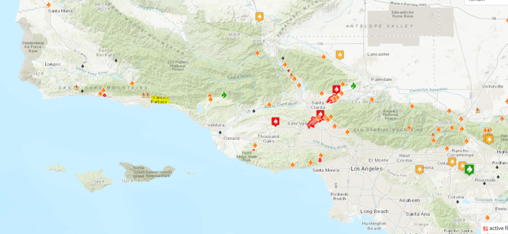
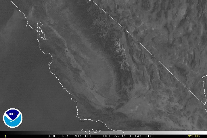
Unlike our last trip to the Golden State, Santa Barbara is a little bit closer to the fires in Southern California, particularly the recently ignited Easy Fire, burning between Thousand Oaks and Simi Valley. What are we looking at for the next couple of days? Respite?

At 753AM, ET, Santa Barbara was reporting clear skies and a temperature of 39 degrees. Shielded by the Coastal Range, and seeing as it is fairly early in the morning, Santa Barbara was shielded from any blustery winds from the interior of the state.
In the next couple of days, a coastal trough is forecast to develop and should finally blunt the winds from the east. A little bit of latent moisture may even turn into a Marine Layer, sneaking up the coast by Saturday morning, making for a cool damp beginning to the weekend.
Tomorrow – Mostly sunny, with some smoky haze, High 74, Low 40
Saturday – Early fog, then clearing and hazy High 73, Low 42

TWC: Tomorrow – A mainly sunny sky. High 77, Low 46
Saturday – Sunny. High 76, Low 48

AW: Tomorrow – Delightful with plenty of sunshine High 75, Low 40
Saturday – Delightful with plenty of sunshine High 74, Low 42

NWS: Tomorrow – Sunny High 80, Low 44
Saturday – Sunny High 77, Low 46

WB: Tomorrow – Sunny High 73, Low 42
Saturday – Sunny High 73, Lw 46

WN: Tomorrow – Sunny HIgh 80, Low 44
Saturday – Sunny High 77, Low 46

FIO: Tomorrow – Clear throughout the day. High 73, Low 58
Saturday – Clear throughout the day. High 74, Low 61

There are some wild differences on the low temperature forecasts in Santa Barbara. Are these even all the same city? A look at the map shows that the fire danger is a little removed from Santa Barbara, but it should still be monitored.

A cool start to November is coming

After consecutive harsh winters, an early start to the below normal cold is not what most wanted to hear, but alas, we are already in the midst of it. Halloween is expected to be awfully chilly, and the beginning to November doesn’t project to be much more comfortable.

The 8-14 day outlook from the CPC, which will take us into the 11th month of the year shows that most of the country east of the Rockies is expected to be below normal.

The Great Lakes are going to be embedded in a fairly strong trough, and it isn’t likely to move very far this week. This trough will lead to a pipeline of moisture from the mid-Mississippi Valley to the Mid-Atlantic, including snow in the southern Great Lakes.

The trough is expected to be so entrenched that the Upper Midwest is actually going to be below normal for the second half of the month as well.

Salisbury, Maryland to Madera, California

All right, friends, it’s about time we engaged in a cross country, 5 1/2 day monster of a road trip. we will cover a whopping 2,914 miles to get from the East Coast to central California. A lot of time on interstates will mean a brisk 66.2mph pace and 529.8 miles covered a day on those full days in the car. We might see snow, and we might see fires Sounds pretty dynamic, doesn’t it?

DAY ONE (Tuesday)

Salisbury, Maryland

Things will be off to a good start on Tuesday, with warm high pressure settling into he Appalachians and throughout the DC/Baltimore region. We shouldn’t have any issues, even with tolls, as we will be traveling the southern route through Ohio, the one that avoids the toll road, but not Columbus. We’ll stay in Lake Darby, a western suburb of the Ohio State Capital.

DAY TWO (Wednesday)
I have some good news for Wednesday! It probably won’t snow! A warm front will reach north towards the southern Great Lakes overnight, and we will be in rain almost from the time we get moving. There is a chance at some thunderstorms over southern Indiana and Illinois, but by the time we reach Missouri, the cooler air will be moving in. The thunder threat will long be over, and instead a chilly rain will overtake the thunder. Maybe after we stop for the night in Devil’s Elbow in central Missouri, a wet snowflake could mix in.

DAY THREE (Thursday)
Undoubtedly, our coldest day will be Thursday, Halloween. How cool is it that we will start Halloween in Devil’s Elbow? We’re going to contend with the remnants of a few snow showers for the first couple hours of the day, concluding before we reach Springfield, and then Oklahoma will simply offer a chilly wind as we nagigate the Sooner State. We will only just start to enter Texas when we call it a day in Shamrock, where west winds suggest we will finally be reaching a bit warmer air.

DAY FOUR (Friday)
November will get off to a pleasant start. Nary a cloud in the sky as we head through the Texas Panhandle and New Mexico, and temperatures should start warming a bit too. We’ll stop for the night in Manuelito, New Mexico, on the Arizona border.

DAY FIVE ( Saturday)
Another day on the road out west, and another day with little to worry about. We’ll navigate Arizona without a concern, and reach southern California where it will be much warmer than we are used to. The day will end near Barstow, but far away from the fire concerns near the coast.

DAY SIX (Sunday)
I suspect that by next weekend, the fire danger in California will be significantly dampened. That will make for a less hazy drive through southern California. Madera looks to be in fine shape for our arrival.

Madera, California
By Jcarrello – Own work, CC BY-SA 4.0, https://commons.wikimedia.org/w/index.php?curid=52965015

Madera, California

The big news story out of California is once again the wildfire season, aided heavily by a robust Santa Ana wind regime. Madera lies in the Central Valley, set away from the flaming hillsides in Wine Country and northwest of Los Angeles, and are under no threat from the flames, though those brisk Santa Anas will surely cause some concerns, won’t they?

At 853 AM, PT, Madera was reporting a temperature of 46 degrees with clear skies and calm winds. Other places further south in the Valley were reporting some light haze as the brisk winds on the hills and mountains of the Golden State was not settling into the Valley.
The atmosphere is finally going to start doing some favors for the beleaguered region, as a strong trough is getting ready to dig into the Great Basin, breaking up the Santa Ana high, and allowing winds to subside. There will continue to be some breeze, though it will shift to become more north-northwesterly as a cold front tries to sneak into the area. With wind off the ocean and picking up the Kincade Fire of northern California, smoke and fog will become more likely in the Madera area Tuesday afternoon into Wednesday evening. Expect some cooler temperatures, though depending on the moisture transported into the region, those could be blunted by a lack of radiational cooling.
Tomorrow – Mostly sunny, with some haze possible, High 70, low 37
Wednesday – A bit cloudy with haze and morning fog more likely, High 68, Low 35

TWC: Tomorrow – Sunny, High 71, Low 37
Wednesday – Mostly Sunny, High 68, Low 34

AW: Tomorrow – Plenty of sunshine, High 71, low 36
Wednesday – Plenty of sunshine, High 69, Low 32

NWS: Tomorrow – Sunny, High 69, Low 39
Wednesday – sunny, High 68, Low 37

WB: Tomorrow – Sunny, Patchy frost in the morning, High 69, Low 49
Wednesday – Sunny, patchy frost in the morning, High 67, Low 36

WN: Tomorrow – Sunny, High 69, low 39
Wednesday – Sunny, high 68, Low 37

FIO: Tomorrow – Clear throughout the day. High 72, low 37
Wednesday – Clear throughout the day. High 70, Low 34

Not often that Victoria-Weather finds itself smack dab in the middle of things. The biggest surprise to me was that the GFS has a warming trend for Wednesday, and it was wholly rejected by all outlets. That doesn’t happen often. Here is the satellite image for central California. If you look closely, you can see the plume from the Kincade Fire north of San Francisco Bay.

It snowed in Texas

A big blast of cold air is is continuing to dive nto the High Plains , setting up a fairly chilly end to the week between the Rockies and the Mississippi. We got that that kicked off with this:

The Amarillo WFO would later report 3″ of accumulation, which is a considerable total for west Texas at any time of year, but particularly in October. The snow fell on the back end of an area of low pressure that also swept a very active line of storms as far south as Brownsville, which lead to significantly cooler temperatures in the Lone Star State.

The sharp upper level trough that is serving as a host to this system will also inform as to where the feature will progress. It’s sliding back north in the Mississippi Delta right now, abnd will continue to the Great Lakes. The jet is going to regenerate in place, and at least for the next week, temperatures will be chilly in the Plains and Mississippi Delta, save for a brief warm up tomorrow afternoon.

This standing trough will mean a chilly end to the month east of the Rockies, and a Halloween that requires all the princesses and Iron Men to be bundled up, but it has other insidious consequences. The stalled trough has also led to a strong area of high pressure over the Great Basin, which has fueled the dangerous Santa Ana winds that are fanning the flames around Los Angeles this month.

All that because of snow in Texas. Yeesh.

Olympia, Washington

Today we’re going to visit the Pacific Northwest, and visit the capital of Washington! Let’s see how Olympia will fare as we head into midweek.

At 654pm, the temperature at Olympia, WA is 51 degrees under fair skies. An area of low pressure is intensifying over eastern Montana, and trailing a front back through ID into OR. This feature will be pushing out into the Plains throughout the day Wednesday, bringing some showers to the Central Plains. Behind this feature, an area of high pressure is settling in over the Pacific Northwest and looks to make it its home over the next couple of days. Some areas of dense fog are possible in the area tomorrow morning before burning off by midday. Some patchy fog is possible Thursday morning too, but will be less widespread. Both days will be dry, with temps lifting a smidge for Thursday.

Wednesday: Some morning dense fog, then becomes sunny. High 58, Low 41.
Thursday: Partly cloudy and a bit warmer. High 61, Low 37.

TWC: Wednesday: AM fog, PM sun. High 59, Low 43.
Thursday: Morning fog again, then afternoon sun. High 62, Low 41.

AW: Wednesday: Times of clouds and sun. High 58, Low 41.
Thursday: Mostly sunny and pleasant. High 62, Low 38.

NWS: Wednesday: Patchy fog then sunny. High 57, Low 42.
Thursday: Mostly sunny. High 62, Low 41.

WB: Wednesday: Partly sunny. High 56, Low 46.
Thursday: Mostly sunny. High 60, Low 42.

WN: Wednesday: Mostly sunny. High 57, Low 42.
Thursday: Partly cloudy. high 62, Low 41.

FIO: Wednesday: Partly cloudy throughout the day. High 58, Low 40.
Thursday: Mostly cloudy throughout the morning, clearing late. High 61, Low 37.

A bunch of high clouds are streaming over the area as a system gets revved up in the Northern High Plains. High pressure takes over the region keeping conditions fairly pleasant.

Did you forget about the clear skies?

Victoria-Weather stumbled on the forecast high last Friday in Toledo, but we came in hot for the Saturday morning lows and totally redeemed ourselves. Or should I say, we came in cold, remembering what happens with clear skies overnight, especially when coupled with a north wind. The low was even cooler than we forecast, but we had the coolest morning low on Saturday, allowing us to catch up with The Weather Channel and Accuweather, who were a bit better on that Friday high, for a three way draw.
Actuals: Friday, High 59, low 36
Saturday – High 65, Low 35

Grade: B – C

Large tornado sweeps through North Dallas

Check out this video, perhaps one of the scariest tornado captures I’ve seen.

A worst case scenario is a large tornado in a populated area, and it is compounded when it moves through at night. This super cell moved through the north Dallas suburbs in a coming together of some of the worst possible circumstances.

It could have been significantly worse though. The storm touched down just 15 miles away from AT&T Stadium, where the Dallas Cowboys were playing the Philadelphia Eagles in front of 75,000 people. In fact, despite the strength of the tornado (I’m guessing it will be at least an EF-3), and it’s long track, there were no reports of fatalities, and only 3 serious injuries.

The NWS hasn’t plotted the track anywhere yet, pending storm surveys, but in real time, the Google Maps traffic report was a good proxy for estimating the storm track:


The storm impacted many commercial areas, wrecking, in what I have seen so far, a Home Depot, a Land Cruiser dealership, and the home of the Dallas Stars’ Tyler Seguin.

The damage reports will continue to roll in, and they will likely continue to provide stark imagery. Keep an eye on the NWS Fort Worth office Twitter feed for updates on the storm surveys. As the picture of damage becomes clearer, we will likely appreciate more how lucky we were that it wasn’t worse.

Nestor slides through the Southeast

What would eventually become Tropical Storm Nestor formed late in the week, and dissipated shortly thereafter. It made landfall with a maximum sustained wind speed of 50mph. There was a storm in New England that had stronger winds than that.

Still, Nestor did provide his fair share of problems. When the center of Nestor arrived, it had been preceded by an off center, heavy batch of rain. Nestor is still a little off kilter. Note that his center in this radar image is actually around Tallahasee.

That’s a lot of rain, but certainly by looking at it, you wouldn’t say that it looks like a tropical storm, would you?

The primary impact the storm had, aside from the typical rain that comes with tropical storms, was a bout of tornadoes east of Tampa Bay. You can see where they ended up on the SPC storm reports.

There haven’t been the severe reports today out of the storm, and now that Nestor is on shore, he will continue to fall apart and get shoved back off shore.

Nestor has been pretty unremarkable storm, particularly when taken in contrast to some of the tough storms in recent years and months, but one needs only to look at the video below to understand that tropical features should always be given some respect.