We’re off on a fairly short trip, that somehow still covers 4 states. It will take 6 1/2 days to cover 439 miles, which equates to a pace of about 67.4mph, which is impressive, given the mountainous terrain we will cover through much of our journey. Thanks, freeways.
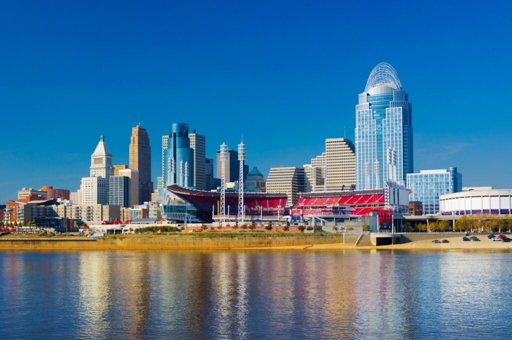
Cincinnati, Ohio
There is a mess of instability in the north Atlantic, and it is extending a few memories into the eastern US. By tomorrow morning, we will see a trough in the Great Lakes and a band on the Atlantic side of the Appalachians, from Virginia to South Carolina. The trough in the Great Lakes is going to leave us alone, though it will be breezy for most of our drive, until about Knoxville. A tropical wave near the Bahamas is going to leak to the north and inflame that rain in the coastal plains. It often seems like it is raining between Knoxville and Asheville. Lean more towards the Asheville side this time, and anticipate a shower or two in Hickory when we role in.
The beginning of this month has brought a relentless cavalcade of systems moving along the east coast, keeping it snowy in New England and the Mid Atlantic and cold in the middle of the country. Where the two meet and merge with the south, AKA the southern Appalachians, it has been icy at times. On Monday in Hickory, there was .16″ of freezing rain, which is enough to cause a fair share of issues for locals. The temperatures climbed into the 50s on Tuesday though, which helped to clear things up. We put together a forecast last Sunday, and it was won decisively by Accuweather. Actuals: Monday – .16″ of rain, High 39, Low 29 Tuesday – High 54, Low 30
Tonight’s forecast comes to us from a part of the country that just got through a wintry slap in the face. Are things soon to be on the up and up?
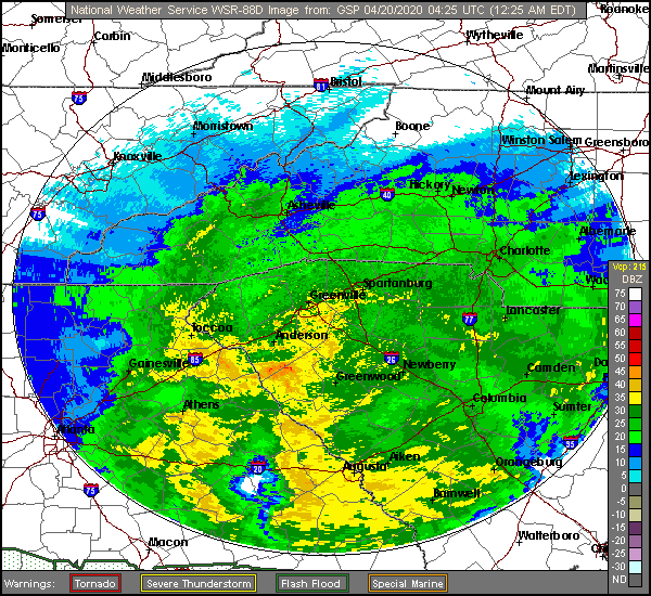
At 953PM, ET, Hickory was reporting mostly cloudy skies with a temperature of 32 degrees. a weak area of low pressure was working its way inland from the South Carolina coast. While this emerging feature is bringing the moisture, the already in place cool temperatures will ensure that the precipitation will be frozen, either as light snow, or perhaps a bit of sleet. Hickory should be at the western most extent of this threatening weather, but nevertheless, there is a winter weather advisory in place for the morning. A southwesterly jet streak at the leading edge of a sharp trough is going to strengthen and draw northeastward. The precipitation tomorrow morning, if there is any, will be shortlived, but the cold air behind the feature will persist through the day. Weak flow will return at the surface as the jet structure becomes muddled aloft. It won’t necessarily be warm in Hickory on Tuesday, but surely, it won’t be as cold. Tomorrow – Morning sleet, with a little bit of rain to finish, otherwise mostly cloudy in the afternoon High 44, Low 28 Tuesday – Partly cloudy, High 53, Low 26
TWC: Tomorrow – Freezing drizzle in the morning, then mostly cloudy late, High 45, Low 27 Tuesday – Some clouds in the morning will give way to mainly sunny skies for the afternoon. High 54, Low 29
AW: Tomorrow – Mostly cloudy and chilly with spotty drizzle High 42, Low 29 Tuesday – Milder with times of clouds and sun High 52, Low 30
NWS: Tomorrow – A chance of freezing rain before 8am, then a chance of freezing rain and sleet between 8am and 10am, then a chance of rain after 10am. Mostly cloudy High 43, Low 29 Tuesday – Sunny, High 51, Low 27
WB: Tomorrow – A chance of freezing rain in the morning. Mostly cloudy with a chance of rain. High 44, Low 30 Tuesday – Sunny, High 53, Low 30
WN: Tomorrow – Mostly cloudy with chance of a light wintry mix, High 43, Low 28 Tuesday – Mostly sunny, High 51, Low 27
FIO: Tomorrow – Possible light rain in the morning and afternoon. High 44, Low 30 Tuesday – Clear throughout the day. High 52, Low 28
The Weather Service and Forecast.io agree with me: The clouds are going to slow down the cooling tonight, and it will actually be colder on Tuesday morning. Other than that, only Accuweather’s precipitation forecast really stands out. Here is the radar tonight, with precipitation falling as rain in South Carolina (where it is being noted)
It seems like in so many circumstances lately, the weather has met the extreme ends of forecasts. Intensity, heat, rainfall, it just seems that we are reaching the worst case scenario all too often. When we get a record high potential in the forecast, as we had in Hickory for the past weekend, and it fails to come close, that seems like big news too! Instead of surpassing the mid-90s record highs over the weekend, It didn’t even hit 90 on Sunday, and stopped at 90 on Saturday. Weatherbug is usually helped by forecasts that stay on the cool side, and it was no different in Hickory. WB gets the W. Actuals: Saturday – High 90, Low 70 Sunday – High 89, Low 70
The weekend is fast approaching, and I think that is one thing everyone can come to appreciate. How much, exactly, will Hickorians (?) appreciate the weather this weekend?
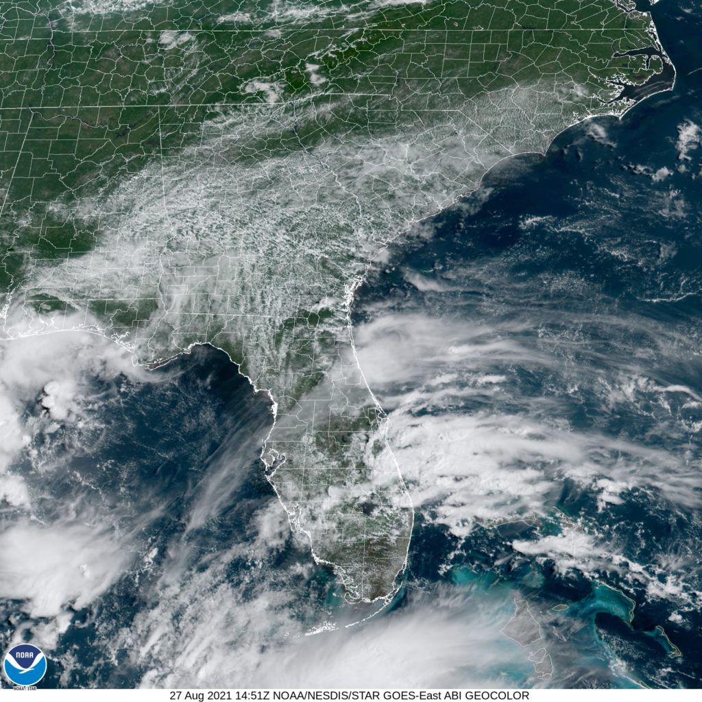
At 1053AM, ET, Hickory was reporting a temperature of 80 degrees. Clear skies were reported across the region, however some fog and low clouds appeared in the valleys closer to Asheville. A band of mid and high clouds was seen along and southeast of a line from Greenville to Fayetteville. High pressure was otherwise seizing the day in the Mid Atlantic. There is some weak baroclinicity, which will organize a bit over the weekend outside the mouth of Chesapeake Bay, but the story everyone will be watching is the rapid intensification of Tropical Storm Ida, which will be a major hurricane in the Gulf of Mexico by Saturday evening, likely to make landfall southeast of Lafayette late on Sunday, after lingering just off shore for the weekend, with potentially disastrous side effects. Hor Hickory, this will function to remove moisture or conflicting flow into the region, and will lead to sun and clear skies, which probably means some toasty conditions. Tomorrow – Sunny and warm with haze and fog early, High 94, Low 70 Sunday – Sunny and hot with morning clouds and fog, High 95, Low 71
TWC: Tomorrow – A mainly sunny sky. High 92, Low 69 Sunday – Sunny skies. High 93, Low 68
AW: Tomorrow – Mostly sunny and very warm High 93, Low 68, Sunday – Mostly sunny and warm with the temperature approaching the record of 94 set in 2007 High 93, Low 69
NWS: Tomorrow – Patchy fog before 8am. Otherwise, sunny, High 93, Low 69 Sunday – Sunny, High 94, Low 68
WB: Tomorrow – Patchy fog in the morning, Sunny. High 91, Low 70 Sunday – Sunny, High 92, Low 68
WN: Tomorrow = Mostly sunny, High 93, Low 69 Sunday – Mostly sunny, High 94, Low 68
FIO: Tomorrow – Humid throughout the day. High 89, Low 67 Sunday – Humid throughout the day. High 89, Low 65
Hurricane Ida will definitely make headlines this weekend, but her presence will ensure the Carolinas have sunny skies this weekend. Satellite now shows some general clouds in the southeastern part of the state, and lingering fog in the mountains.
A large area of low pressure moving through your area is usually a recipe for a botched forecast. That wasn’t the case at the beginning of last week in Hickory, where as we issued the forecast, the western North Carolina town was at the beginning of what would be 7/10ths of an inch of rain. Despite that, forecasts for the two days were collectively very good. Maybe because the rain was over well before noon on Monday. Accuweather and the Weather Service tied for the top forecast. Actuals: Monday – .7 inches of rain, High 68, Low 49 Tuesday – High 73, Low 45
I-40 runs all the way from North Carolina to California, and yet we will spend the first part of this trip getting up to I-80. The drive will be a 5 day excursion that covers 2,635 miles. Our 5 days will be evenly spaced at 527 miles a day. or rather just short of 66mph. We have some ground to cover, so we should probably get a move on.
Hickory, North Carolina
DAY ONE (Tuesday) A weak tail of a cold front will be sweeping through the Appalachians overnight tonight. Could there be a little bit of mountain snow in the Appalachians. It will probably be only rain along our route through the mountains, as it will likely only be possible on the west side of the hills. Rain might be a possibility all the way to Crossville, but expect cool and dry air to move in by the late afternoon as we touch two more states, Kentucky and Illinois, where we will stop in Vienna, in far southern Illinois.
DAY TWO (Wednesday) A little bullet of low pressure is going to arise in the southern Plains and move through the central US. The warm front will be a traditional stratiform rain maker, just like we want to see in the spring and summer months. That is to say, no severe weather and no snow. We’ll be in the rain for most of the time spent in Missouri. Rain will lighten north of about St. Joseph but there will certainly be some lingering sprinkle activity north to Nebraska City, along the Iowa/Nebrasla state line.
DAY THREE (Thursday) The weather will become more congested as we head west. Nebraska looks like it will be pretty OK as we move along I-80, but don’t be surprised if an emerging feature brings some light ran to our drive after we pass into Wyoming. We’ll make it to Turtle Rock in the midst of a National Forest between Cheyenne and Laramie.
DAY FOUR (Friday) Some atmospheric troughing will continue over the Wyoming Rockies, and a splash of rain with maybe *MAYBE* some snow in the peaks will accompany our trip along I-80 in Wyoming. Utah will be a different story as the Great Basin will be bathed in sunlight. It will work out just so that our day will end in West Wendover, Nevada, right along the UTah border.
DAY FIVE (Saturday) What better way to finish a long week of driving than with a bright, sunny drive without the threat for inclement weather. Truckee and Lake Tahoe can be a bear when the weather is active, especially this time of year, and we just won’t have anything to really worry about. Sunscreen, maybe, if you want to go out while you are in town.
It’s interesting that Hickory, NC is clearly the largest Hickory in the world, but the most famous is one in Indiana that doesn’t even exist.
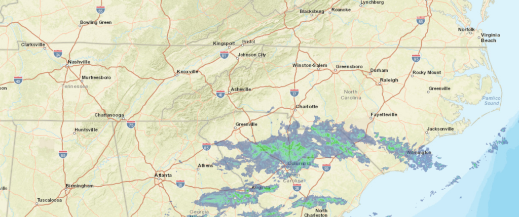
At 1153PM, ET, Hickory was reporting a temperature of 55 degrees with overcast skies. There were a few sprinkles around town, which was simply a the leading edge of what will be a rainy overnight. The heaviest rain still resided in South Carolina, but it was moving into the Tar Heel State. A strong area of low pressure has brought another day of heavy weather to the southeastern US, but will be pressed east and offshore before any of the worst of the weather can reach Hickory. The center of low pressure is going to move towards the Carolina coast on its trek northeastward, with moist air advecting back to the west on the back and north end of the low. This will likely enhance the threat for precipitation through Monday morning, at least. The jet stream is running in parallel right now, and a trailing, still strong but less active system is traversing the Canadian Prairies. After Monday dries out, the second system will swing a cold front through the area that will help make things breezy, with a bit of a cool down Tuesday evening. Tomorrow – Rain through the morning, then improving, High 68, Low 51 Tuesday – Partly cloudy, with increasing clouds late, High 71, Low 48
TWC: Tomorrow – Rain early. Decreasing clouds with mostly sunny skies by afternoon. High 70, Low 49 Tuesday – Sunny. High 70, Low 46
AW: Tomorrow – Periods of rain in the morning, then clouds giving way to some sun in the afternoon High 69, Low 50 Tuesday – Sunny to partly cloudy, breezy and pleasant High 72, Low 45
NWS: Tomorrow – Occasional showers, mainly before 11am. Patchy fog before 10am. High 68, Low 49 Tuesday – Sunny,High 71, Low 46
WB: Tomorrow – Patchy fog in the morning. Cloudy with showers in the morning then mostly sunny with a chance of showers in the afternoon, High 68, Low 51 Tuesday – Sunny breezy with highs in the lower 70s, High 69, Low 48
WN: Tomorrow – Partly cloudy with showers, High 68, Low 50 Tuesday – Mostly sunny, High 71, Low 46
FIO: Tomorrow – Light rain overnight and in the morning. High 69, Low 48 Tuesday – Clear throughout the day. High 70, Low 45
There wasn’t rain before we started this forecast, but there is now, in Hickory. Looking at the radar, though, I think you can see that it was inevitable.