College Station, Texas

Texas A&M is located in College Station, and is home to a very good meteorology school. One suspects that at least one of the forecasters in this competition will have a close connection with College Station.

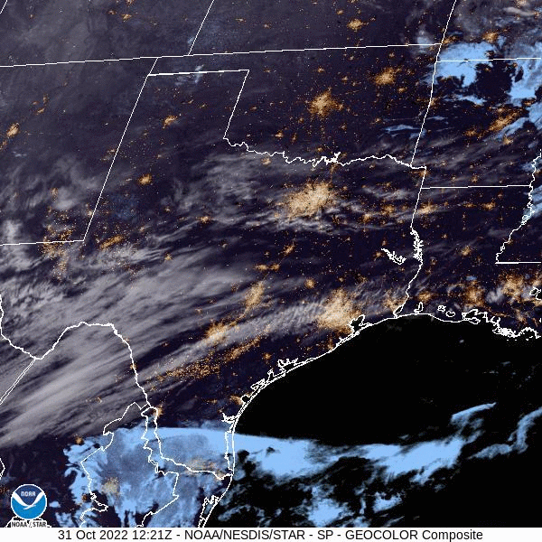
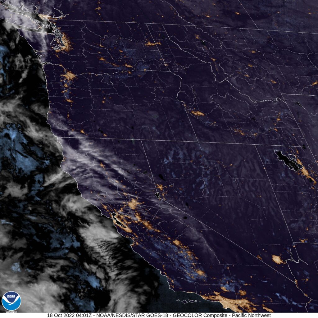
AT 1253PM, CT, College Station was reporting a temperature of 73 with clear skies. A jet streak aloft over east Texas was evident in some streaming cirrus over the region. Further to the south, a thatch of clouds over southern Texas represented return flow on the back end of surface high pressure. As the jet streak carries to the northeast, the Gulf will open further, with moisture allowed to trek north through the state.
A weak trough at the entrance of the jet streak is going to exacerbate the shower activity in south Texas, with rain bubbling up through much of the southern half of the Lone Star State. As this upper wave transitions away, and an upper ridge establishes over the center of the country, high pressure will recommit to the southeastern US. Flow into an area of low pressure developing in the High Plains will route north of College Station, and a warm, dry start to November is anticipated.
Tomorrow – Chance of evening showers, otherwise warm, High 73, Low 58
Wednesday – Partly cloudy, High 76, Low 60

TWC: Tomorrow – Cloudy early with partial sunshine expected late.  High 75, Low 58
Wednesday – Partly cloudy skies. High 80, Low 56

AW: Tomorrow – Intervals of clouds and sunshine with a couple of showers High 73, Low 60
Wednesday – Pleasant with sun and areas of low clouds High 79, Low 60

NWS: Tomorrow – A 20 percent chance of showers before 1pm. Partly sunny, High 72, Low 59
Wednesday – Mostly sunny, High 79, Low 56

WB: Tomorrow – Mostly cloudy in the morning then becoming mostly sunny. High 71, Low 60
Wednesday – Mostly sunny, High 79, Low 58

WN: Tomorrow – Partly cloudy, High 72, Low 54
Wednesday – Partly cloudy, High 79, Low 56

FIO: Tomorrow – Mostly cloudy throughout the day. High 70, Low 57
Wednesday – Mostly cloudy throughout the day. High 77, Low 59

Tomorrow, in a worst case scenario, might necessitate kids staying indoors and eating a whole lot of candy. Happy Halloween!

Cold enough for you?

Pocatello behaved mostly as expected, if you managed to sleep in every day. If you woke up early though on the 18th and 19th, you would find that temperatures were significantly colder than what most outlets forecast. It wasn’t a bad forecast overall for the winners (Who happened to be us, Victoria-Weather) because the high temperatures were handled well, and the precipitation threat was for later in the week. Low temperatures ended up as low as 26 on the 19th, which was a bit cooler than the 40s WeatherNation threw out there.
Actuals: October 18th, High 76, Low 30
October 19th, High 73, Low 26

Grade: C-D

Coming Soon…

The question when I tell you what is coming soon is, as always “how soon”? I don’t have a good answer for that, but my hope is a more regular schedule between now and the holidays, before things invariably go sideways again. Let’s keep our fingers crossed!

Jefferson City, Missouri

Road Trip from Jefferson City to Casper, Wyoming

Racine, Wisconsin
Road trip from Lakeland, Florida to Racine

Columbia, Missouri to Fond du Lac, Wisconsin

If you know any thing about me, know that I love it that we take road trips that are a bit different The trip, just shy of 8 hours, makes it’s biggest turn at Cedar Rapids. Has that ever happened? I don’t think so! It’s a 491 mile trek, covering 3 states at a pace of about 62mph. And we get to see Cedar Rapids!

Columbia, Missouri

Low pressure spinning over the mountains is going to sink deeper to the southern Plains. The light rain showers that are threatening the Upper Midwest are going to be drawn south to the more organized region of instability in Texas by the time we would depart tomorrow. The weather will get less cloudy and potentially a few degrees warmer as we head to eastern Wisconsin.

Fond du Lac, Wisconsin

Passing showers pass by

There was a threat of some showers cycling through south Texas on the back of tropical storm Karl, which was spinning down in the Bay of Campeche. Tropical storms, until the reach land, tend to draw moisture towards themselves, and this was the case in Brownsville in the middle of October. It was hot and dry in Brownsville for our forecast period, which led to a forecast victory for WeatherNation, which had the combined success of a their piggybacking off of the Weather Service’s temperature forecast, and their own foresight to leave rain out of the forecast.
Actuals: October 14th, High 92, Low 74
October 15th, High 91, Low 74

Grade: A – B

Columbia, Missouri

Columbia is the home of the University of Missouri, and like most of the population of Missouri, isn’t terribly far from St. Louis.

At 154PM, CT, Columbia was reporting a temperature of 83 degrees with fair skies. Low pressure moving through the northern Plains was inducing brisk southerly winds that were bringing temperatures up to unusually high levels, and introducing a little bit of moisture to the atmosphere. Columbia was on the cusp of drought, but is not presently under a red flag warning, even with the gusty winds.
The strong feature in the Plains is going to gain a tighter circulation and start moving north toward the Dakotas and Minnesota. The cold front, owing to the primarily northerly vector of the system, will be slow moving. The boundary will flare in Kansas and Oklahoma tomorrow morning, and slowly traipse across Missouri before arriving in Columbia in the evening on Monday. The base of the trough will be fertile ground for more cyclonic development, and a wave will develop in the Red River Valley and move north, ensuring that after the rain and thunder start on Monday, it will persist, though likely with less thunder, through the early part of Tuesday, with colder temperatures following.
Tomorrow – Rain and thunder arriving late after another warm October day. High 74, Low 54
Tuesday – Rain through the afternoon, then clearing, High 54, Low 46

TWC: Tomorrow – Cloudy with occasional rain in the afternoon. Thunder possible High 72, Low 50
Tuesday – Periods of rain High 52, Low 49

AW: Tomorrow – Mostly cloudy, breezy and not as warm; a couple of afternoon showers and a heavy thunderstorm High 72, Low 55
Tuesday – Cloudy, breezy and cooler with heavy rain tapering off High 55, Low 46

NWS: Tomorrow – Showers, mainly after 2pm High 73, Low 59
Tuesday – Showers likely, mainly before 2pm. Mostly cloudy High 59, Low 46

WB: Tomorrow – Cloudy, showers in the afternoon, High 74, Low 56
Tuesday – Showers likely mainly in the morning, High 57, Low 46

WN: Tomorrow – Mostly cloudy with showers, High 74, Low 63
Tuesday – Mostly cloudy with scattered showers, High 56, Low 48

FIO: Tomorrow – Rain throughout the day. High 79, Low 63
Tuesday – Rain throughout the day. High 67, Low 46

It is non-standard temperature season! What a rainy forecast for eastern Missouri. I wouldn’t be surprised to see several inches of rain in some parts of the state. The low is easily apparent up in Montana even this afternoon.

A few more clouds, a few more drips, a few less blankets

The middle of October was a fairly quiet time for those interested in all things weather, so a little bit of a disturbance rippling from the southern Plains to the mid-Mississippi Valley qualified as interesting. It certainly added intrigue to our forecast for Fayetteville, as it resulted in a smattering of rain on both days of the forecast period, and even more surprisingly, led to fairly warm overnight lows from the 10th to the 11th. The Weather Channel won because they had warmer lows on the 11th, but also were one of the only two outlets with rain in the forecast on both days of the period.
Actuals: October 10th, .01 inches of rain, High 76, Low 50
October 11th, .02 inches of rain, High 81, Low 68

Grade: C-D

Pocatello, Idaho

I saw that we are on the cusp of some changes to the pattern in the interior northwest. It is October, so perhaps you can guess what kind of changes those might be.

At 1153AM, MT, Pocatello was reporting clear skies and a temperature of 62. The clear skies were leading to chilly nights with the low dew points, but the sunshine meant temperatures were unbound in the afternoon, and record highs have been dotting the region of late. The low trough off the west coast in conjunction with the ridge has established what is known as a Rex Block, stifling flow in Idaho.
The western US is going to remain under this Rex Block until the weekend, and flow through the region will remain fairly stagnated. Expect some morning haze or smog, especially in the valleys, thanks to the lack of flow at the surface, but continued warm temperatures and sunny skies in the afternoon. Things will be quite a bit different this weekend, however.
Tomorrow – Sunny with haze, High 76, Low 35
Wednesday – Sunny, hazy in the morning, High 73, Low 34

TWC: Tomorrow – Sunny skies High 76, Low 36
Wednesday – Intervals of clouds and sunshine. High 74, Low 35

AW: Tomorrow – Warm with plenty of sunshine High 76, Low 34
Wednesday – Brilliant sunshine and warm with the temperature approaching the record of 78 set in 1950 High 75, Low 35

NWS: Tomorrow – Sunny, High 74, Low 42
Wednesday – Sunny, High 73, Low 43

WB: Tomorrow – Sunny, areas of frost in the morning, High 72, Low 35
Wednesday – Sunny, High 71, Low 36

WN: Tomorrow – Sunny, High 74, Low 42
Wednesday – Mostly sunny, High 73, Low 43

FIO: Tomorrow – Clear throughout the day. High 74, Low 40
Wednesday – Partly cloudy throughout the day. High 72, Low 37

Pretty different forecast lows, but consistent elsewhere. Makes sense when the satellite imagery looks like this. By the way, the change I hinted at in the intro is coming over the weekend. It’s going to get cold and snowy for a lot of the Northwest.

Brownsville, Texas

Brownsville is part of a surprisingly well populated stretch in the far southern part of Texas, including Harlingen and McAllen. Brownsville is the furthest south, and closest to the Gulf of Mexico. It also happens to be significantly further from any town, excepting Harlingen and McAllen, than anyone really expects.

At 953AM, CT, Brownsville was reporting a temperature of 83 degrees with clear skies. A dry line was spread through central Texas, and while the Dallas area had dew points in the the 40s, it was already in the mid 70s along the Rio Grande. There was a threat for strong thunderstorms closer to Corpus Christi this afternoon, and some of those shower and thunderstorms flaring south towards Brownsville can’t be ruled out later today. Additionally, Tropical Storm Karl was churning away in the Bay of Campeche. Tropical Storm Warnings extended to Matamoros on the other side of the Rio Grande, but his presence only raised the threat for coastal thunderstorms this afternoon.
Karl is moving southward, expected to landfall near Coatzcoalcos on the Campeche coast, so the attention will be turned to the dry line to the north of Brownsville. Without the counterclockwise rotation from Karl, the dry line will lose it’s potency as well. The dry line dichotomy will linger through the period, but the threat for showers and storms will abate over deep south Texas. As Karl continues to waste away in Central America, Brownsville will be more stable than normal for a hot humid stretch, with mostly sunny skies and temperatures preparing to climb.
Tomorrow – Partly cloudy, High 90, Low 73
Saturday – Mostly sunny, High 92, Low 73

TWC: Tomorrow – Partly cloudy with afternoon showers or thunderstorms. High 89, Low 73
Saturday – Intervals of clouds and sunshine. High 92, Low 73

AW: Tomorrow – Partly sunny with a thundershower in spots in the afternoon High 90, Low 73
Saturday – Partly sunny and humid; breezy in the afternoon High 91, Low 72

NWS: Tomorrow – A 20 percent chance of showers and thunderstorms. Mostly sunny High 90, Low 74
Saturday – Mostly sunny, High 92, Low 74

WB: Tomorrow – Mostly sunny, High 89, Low 74
Saturday – Mostly sunny, high 90, Low 73

WN: Tomorrow – Partly cloudy, High 90, Low 74
Saturday – Mostly sunny, High 72, Low 74

FIO: Tomorrow – Humid and partly cloudy throughout the day. High 87, Low 73
Saturday – Humid and partly cloudy throughout the day. High 88, Low 73

Its strange that the driest forecast is the coolest forecast. Strange. Karl is showing up dramatically on the Gulf satellite imagery.

Memories of NorCal

Prepandemic, my wife and I went to Sonoma for a friend’s wedding. Not only did I end up underdressed for the wedding (it was very fancy, and I was not), but I was also underdressed for the weather. It was significantly colder than expected, and I simply didn’t have enough warm weather gear for the blustery winds and chilly air. Beautiful country though. At the end of September, we put together a forecast for Santa Rosa, not far from Sonoma, and I had some serious flashbacks. After a gorgeous day on September 30th, onshore flow brought more clouds and chilly north Pacific air into Santa Rosa. Temperature forecasts were warm by a matter of double digits. Not great! The Weather Channel picked up a victory, but not one to be proud.
Actuals: September 30th – High 88, Low 50
October 1st, High 65, Low 51

Grade: D