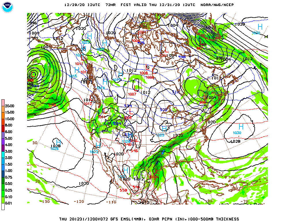
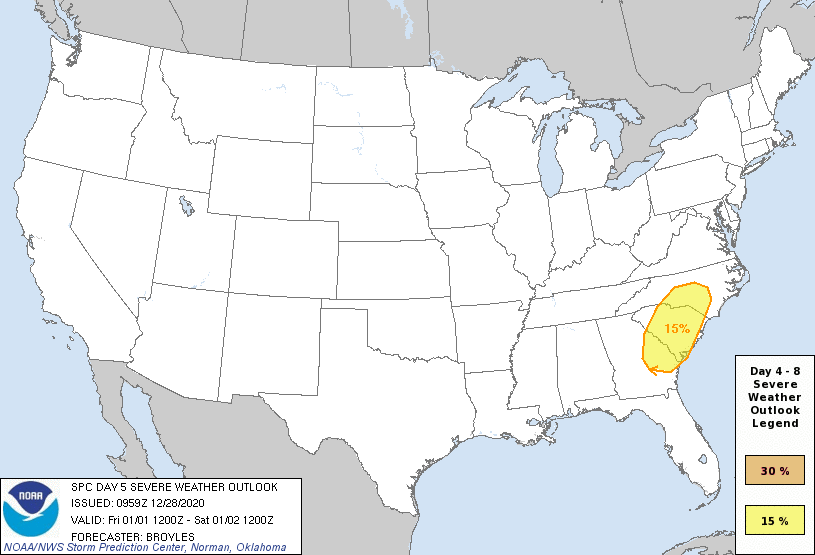
As is often the cast with mid-winter systems, a deep upper level trough will feature two iterations. The first will be a fast moving area of low pressure moving through the upper Midwest with a burst of snow in the Upper Midwest and Great Lakes. The second will emerge as the base of the upper trough pivots further south into warmer air, a stronger feature will develop.
In this case, the deep, secondary low will really emerge over east Texas. Tightly wound and with the clash of air masses one needs to generate some convection.
The storm will quickly shift to the northeast and get more organized as it does so, introducing a threat for severe weather in the Lower Mississippi Valley as it does so.
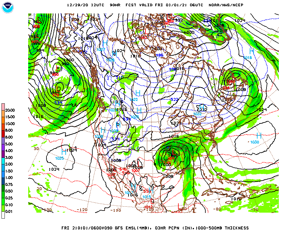
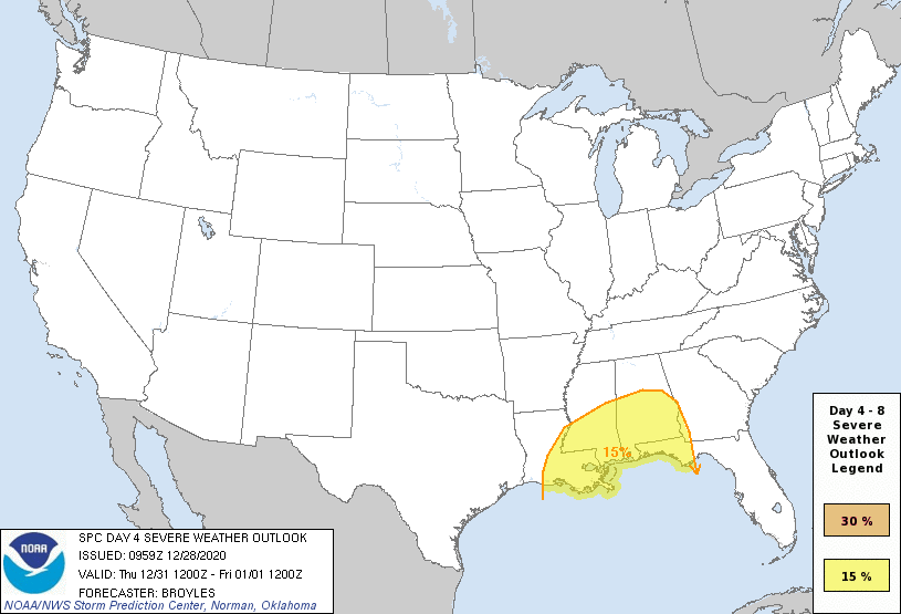
Here is the risk for severe weather on New Years Day, or Day 4 in the SPC parlance.
If there is one good thing about the timing of these storms, it is that their intensity will require day time heating, and overnight severe weather is not expected. Still, as the storm continues to lift to the north-northeast, severe weather is already on the agenda for January 2nd as well.
The back end of the storm isn’t going to be nearly as moisture rich as the warm sector, in good spring fashion, but there will still be snow associated with the feature, particularly through the Great Lakes.
2020 is finally almost over, but 2021 really wants to give us it’s best shot right out of the gate.
I hope everyone had a happy Holiday. If you were among the millions who were in the midst of winter weather during the Christmas Season, then I hope this forecast for southern California can fill you with warmer thoughts.
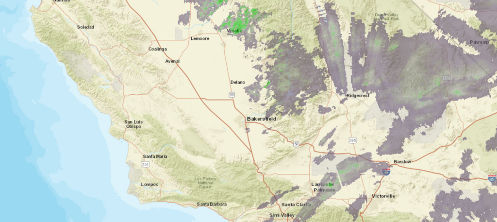
At 1054AM, PT, Bakersfield was reporting light rain and a temperature of 54 degrees. A narrow band of showers lay across the southern Valley, with more industrious precipitation in the higher terrain of the Sierras and Tehachapi Mountains. This was a more forceful preview of a storm coming later today and early in the workweek. A deep trough digging into the Pacific Coast is a tailing lobe over a broader jet trough covering the better part of the northern half of the country. The precipitation follows the course of the exiting part of the jet streak from the lobe, but a well defined area of surface low pressure looms off the California coast. Rain and mountain snow will really intensify overnight tonight, with the feature fully onshore shortly after midnight. Rain is likely in Bakersfield, but significant snow in the mountains ringing Bakersfield are all under Winter Storm advisories. The good news is that the storm will move quickly, and be chased out by dry California air by the end of the day. Tuesday looks to be atypically cool, but dry. Tomorrow – Rain likely, otherwise mostly cloudy, High 56, Low 46 Tuesday – Early AM drizzle, then sunny and cool, High 52, Low 40
TWC: Tomorrow – Partly cloudy skies during the morning hours will become overcast in the afternoon (early rain) High 57, Low 46 Tuesday – Considerable clouds early. Some decrease in clouds later in the day. High 55, Low 33
AW: Tomorrow – Cloudy with a shower in spots HHigh 56, Low 45 Tuesday – Periods of clouds and sunshine High 54, Low 40
NWS: Tomorrow – Rain likely, mainly between 8am and 9am. Patchy fog between 7am and 8am. Otherwise, mostly cloudy, High 54, Low 43 Tuesday – Partly sunny, High 51, Low 41
WB: Tomorrow – Mostly cloudy with a 50 percent chance of rain, High 56, Low 44 Tuesday – Mostly cloudy in the morning, then becoming mostly sunny, High 53, Low 42
WN: Tomorrow – Mostly cloudy with light rain likely, High 54, Low 43 Tuesday – Partly cloudy, High 51, Low 41
FIO: Tomorrow – Rain overnight and in the morning. High 57, Low 44 Tuesday = Partly cloudy throughout the day. High 55, Low 41
Model guidance definitely doesn’t fully clear the Bakersfield by the early afternoon tomorrow, as some outlets suggest, but Bakersfield is not an easy place to get steady precipitation, which is why nobody carries it as late as we do. Still, it arrived early, so why not stay a while? Here is the radar, with that rain hanging around, especially in the mountains.
It worked out mostly by accident, but today is the beginning of the NBA season, featuring the reigning champions, the LA Lakers, and their star, LeBron James, from Akron. It was meant to be.
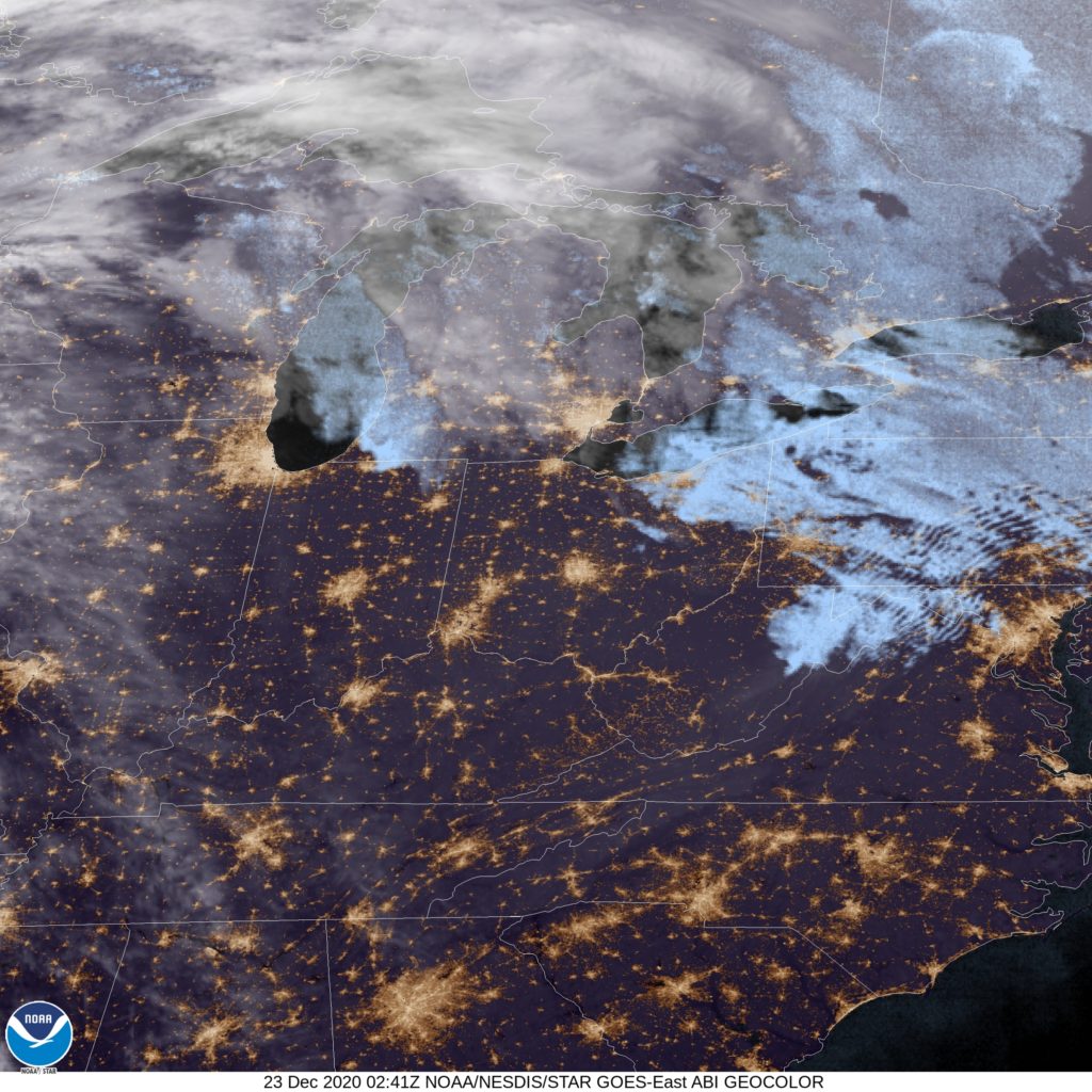
At 851PM, ET, Akron was reporting a temperature of 37 degrees with overcast skies. Winds were light across the region, but generally southerly in response to a warm front over the northern Great Lakes right now. The warm front is attached to a rapidly strengthening area of low pressure that promises to ruin the end of the week in the Upper Midwest and Great Lakes. The clouds over Akron right now are chaff found across the Eastern Great Lakes, which will shunt off to the northeast as warm air advances in ahead of the cold front coming through later this week. Wednesday should be warm, but increasingly windy and cloudy, with the front arriving on Christmas Eve, near dawn. It should be warm enough that it will start with rain, with a secondary circulation rising from the Tennessee Valley towards eastern Ohio. This advance will stall the cold air, which will dlay the transition to snow until much later, perhaps until the evening on Christmas Eve. Tomorrow – Mostly sunny, increasingly windy and cloudy, High 50, Low 32 Christmas Eve – Rain starting early, intensifying and then turning to heavy wet snow around nightfall. 2-4″ by midnight. High
TWC: Tomorrow – Cloudy skies (Late rain). High 51, Low 33 Christmas Eve – Rain early with snow in the afternoon. High 51, Low 27
AW: Tomorrow – Mild with sun through high clouds; breezy in the afternoon (Late RAin) High 50, Low 30 Christmas Eve – Rain mixing with, then changing to snow late, accumulating 1-3 inches; watch for a rapid freeze-up High 47, Low 25
NWS: Tomorrow – Mostly cloudy, High 49, Low 31 Christmas Eve – Rain before 2pm, then rain and snow between 2pm and 4pm, then snow after 4pm. High 46, Low 24
WB: Tomorrow – Mostly cloudy (late rain) High 48, Low 34 Christmas Eve – Rain, Snow in the afternoon. Light snow acumulation, High 49, Low 27
WN: Tomorrow – Mostly cloudy with isolated showers, High 49, Low 31 Christmas Eve – Cloudy with a wintry mix, High 47, Low 39
FIO: Tomorrow – Windy overnight and in the evening. High 50, Low 32 Christmas Eve – Rain (with a chance of 2–4 in. of snow) throughout the day. High 48, Low 22
It’s too bad that the forecast couldn’t come in the midst of wet weather. The NWS has rolled out new radar imagery and I could have used it. Alas, here is a look at Akron, on the cusp of clear skies. Don’t get used to them.
The forecast didn’t waiver by a lot in Grand Rapids, but there was one element that separated a couple of outlets. Just north of a system that would dump snow measured in feet on the mid-Atlantic, west winds off Lake Michigan brought a few snow showers to Grand Rapids on Wednesday, which elevated the results for only two outlets: Accuweather, and the winner of the day, Victoria-Weather. For results to fluctuate much on a precipitation error, the temperatures had to have been fairly close, which they were. The Weather Channel was good on temperatures, but off on the snow, which set them back, like nearly everyone else. Actuals: Tuesday – High 29, Low 19 Wednesday – Trace of snow, High 30, Low 23
I’m going to be pretty quick with the forecaster of the month: It was WeatherNation. They don’t get many titles so it’s too bad we don’t get to spend too much time discussing it. Residents of the mid Atlantic, particularly in downstate New York might be particularly miffed that we don’t get a chance to really dive into WeatherNation’s month.
Starting early tomorrow afternoon, a mix of rain and snow, depending on how near the coast you live, will start in Long Island and southern New York (sooner in the DC and Philadelphia areas) and intensify into the evening, until we can look at something like this after sunset through midnight.
Precipitation from the Big Apple northward is likely to be snow, while Long Island may see quite a bit of mixed snow, sleet and rain. Where it is all snow, including in New York, over a foot of accumulation is in the forecast.
Long Island doesn’t necessarily get the best of the weather however. In addition to whatever sloppy accumulations they get in Long Island, residents of the area can also look forward to wind gusts approaching 50mph. What’s worse? That’s a matter of personal opinion.
It will still be over a week, but this gives the mid-Atlantic a good shot at a White Christmas.
Owensboro seemed to be a pretty easy forecast when we issued it last week. Well. A combination of a stout ridge at the upper levels and an infusion of warm air thrust northward by an advancing area of low pressure shot high temperatures well into the 60s, which was a sight warmer than anyone anticipated. The Weather Channel and Accuweather tied to have the “least bad” forecasts. Actuals: Thursday: High 67, Low 35 Friday – High 65, Low 41
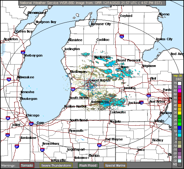
Welcome back to Victoria-Weather’s forecasting adventure zone. Grand Rapids is down wind of Lake Michigan, with fairly strong gusts being noted. Not to give anything away about the precipitation or anything.
At 453PM, ET, Grand Rapids was reporting temperature of 28 degrees with mostly cloudy skies. There have been a few streaks of light snow across western Michigan today, provided by winds off the Lake of up to 30mph. This is certainly a microscale event, as more generally, high pressure dominates the region. A shortwaved ridge over the Ohio Valley and Great Lakes is contributing to the high pressure focused over the Upper Midwest and spreading into the Great Lakes. A deep, broad jet trough will overtake the middle of the country and birth an area of low pressure over the northern Gulf of Mexico, which will translate swiftly to central Appalachia. The existing surface ridge will squash the system to the south and east, away from Lower Michigan, but the induced northwest flow will mean a chance for some flakes, particularly on Wednesday, as well as dropping temperatures later in the week. Tomorrow -Mostly cloudy, High 33, Low 21 Wednesday – Isolated flurries with mostly cloudy skies, High 30, Low 21
TWC: Tomorrow – Mostly cloudy. High 30, Low 22 Wednesday – Overcast High 33, Low 24
AW: Tomorrow – Sun through high clouds High 32, Low 18 Wednesday – A couple of snow showers in the morning; otherwise, mostly cloudy High 35, Low 20
NWS: Tomorrow – Partly sunny, High 29, Low 19 Wednesday – Cloudy High 33, Low 24
WB: Tomorrow – Partly sunny, High 29, Low 22 Wednesday – Mostly cloudy, High 31,Low 24
WN: Tomorrow – Partly cloudy, High 29, Low 19 Wednesday – Mostly cloudy, High 33, Low 24
FIO: Tomorrow – Mostly cloudy throughout the day. High 31, Low 24 Wednesday – Overcast throughout the day. High 33, Low 26
Well, it’s going to come down to cloud cover, but it’s interesting that we are moving in different directions on those highs, right? Here are a few bands of lake effect snow in western Michigan
A cut off low off the Pacific Coast eventually brought a pretty healthy burst of snow, rain and thunderstorms to the middle of the country before shifting into eastern Canada and New England. Along the way, it mangled some temperature forecasts in the Tucson area. The specific credit for that can be given to the gusty winds that hit 30mph on the 7th, and in the 20mph range on the 8th. High temperatures on the 7th were warmer than expected, and the lows on the 8th were well above normal, all thanks to winds coming out of the southern Rockies and the arid plains of west Texas. The Weather Channel had the top forecast, but won narrowly as everyone had similar forecasts. Actuals: December 7th – High 79, Low 39 December 8th – High 77, Low 55
Grade: D
(Please note, the days used in the forecast should have been “tomorrow” and “Tuesday” rather than Monday)