I am, of course, talking about our recent posting frequency. Whew! This Fayetteville verification is 2 weeks overdue, if that gives you an idea the latency issues we are having. This was a pretty solid forecast from all comers, with Victoria-Weather taking the top spot, after two other outlets incorrectly suspected thunderstorms would bleed into the eastern Carolinas after developing in the shadow of the Appalachians. Nope! V-W gets the win. Actuals: July 16th, High 93, Low 73 July 17th, High 93, Low 74
We’re headed towards a busy stretch of forecasting, and we’ll see a lot of the country as well, which will provide us a good look at the country as a whole. I think it could be fun!
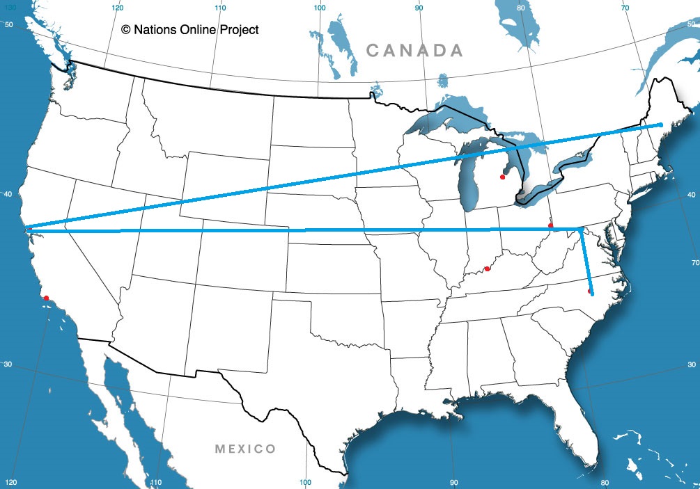
Napa, California Road Trip from Lewiston, Maine to Napa
Road Trip from Napa to Cumberland, Maryland
Durham, North Caorolina Road Trip from Cumberland to Durham
Hey gang, we’re almost at the weekend! At Victoria-Weather, we are planning on kicking things off with a 4 day trip out to Reno. We’ll cover 2,337 miles at a pace of 68.7 windswept miles per hour. The last day, which is often the case for us, will be a longer day, with about 550 miles passing by on the first three days. Road travel and camping are the way to live in this age, and perhaps this journey will provide just that opportunity.
DAY ONE (Saturday)
Gadsden, Alabama
Hey! Who is that in the Gulf of Mexico? Why, it’s Tropical Storm Hanna, already the 8th storm of the season, ready to soak south Texas. What that means for our journey is a reduction in the instability that filters north to our route from Gadsden to Blue Springs Missouri, the Kansas City suburb we intend to rest our heads. Instead of the threat for area showers and storms after noon throughout the day, I think that if we can make it past Hopkinsville, Kentucky by 1pm, we might be storm free all day. Hey, and Kansas City has a lot of spots to stop, including campgrounds. All around a pretty good day.
DAY TWO (Sunday) A cold front is going to move through the high Plains and Upper Midwest this weekend, and again, Hanna is going to play havoc with the storms’ intentions. Instead of heavy soaking rains, there will only be a few shpwers and storms on Saturday, but as Hanna deteriorates on land, the moisture will return to Nebraska and Iowa. Expect the best chance for thunderstorms to come around Lincoln, but with chances for more activity as far west as North Platte. We’ll reach Sidney, which is an oasis in the Nebraska Panhandle, and call it an ight.
DAY THREE (Monday) The summer monsoon is something of a moving target. Like, literally, the target moves every day, and truly, guidance isn’t a whole lot of help. Depending on your flavor of choice, you might get some storms in Nevada, or they might show up in Utah. Let’s plan for the worst and hope for the best. It should be dry through Wyoming, at least, even if we see a stray storm in Utah, where we will stop in Magna, on the west side of Salt Lake City.
DAY FOUR (Tuesday) The way it looks, our long drive on Tuesday will mostly be in the clear, though as the time hits the afternoon, there could be an isolated storm around Elko or Winnemucca. IT would be short lived, however, and we would almost certainly be in good shape when Reno comes to pass. It will be plenty hot though.
It’s opening day for baseball fans, at long, long last, so let’s go to a state that does not have any baseball whatsoever, because Victoria-Weather is excellent with timing, if nothing else.
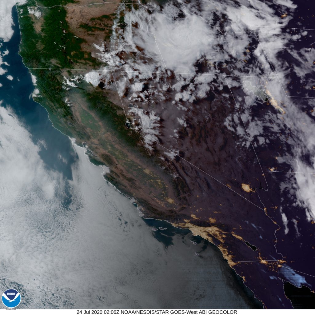
At 755PM, MT, Reno was reporting a temperature of 79 degrees with winds of 35mph. There were some clouds over the Sierras around Lake Tahoe, and the end of showers and storms within that activity were leading to the localized gusts. The trend will continue to be towards clearing as the work week ends and the weekend arrives. Expect surface high pressure to continue to build across the Intermountain West, with sunny skies and warm temperatures for Reno. Tomorrow – Partly cloudy, High 92, Low 59 Saturday – Sunny, High 93, Low 57
TWC: Tomorrow – Sunshine and some clouds High 89, Low 56 Saturday – Generally sunny despite a few afternoon clouds High 92, Low 58
AW: Tomorrow – Mostly sunny High 90, Low 57, Saturday – Sunny to partly cloudy High 92, Low 59
NWS: Tomorrow – Widespread haze before 11am. Sunny High 91, Low 59 Saturday – Sunny High 92, Low 60
WB: Tomorrow – Sunny. Haze in the morning. Slight chance of showers and thunderstorms, High 87, Low 57 Saturday – Sunny, High 91, Low 59
WN: Tomorrow – Hazy, High 90, Low 59 Saturday – Mostly sunny, High 92, Low 60
FIO: Tomorrow – Clear throughout the day. High 87. Low 62 Saturday – Clear throughout the day. High 92, Low 64
Here is a look at the satellite. Those diminishing clouds brought the breeze, but their diminishing will lead to a rapid cooldown tonight.
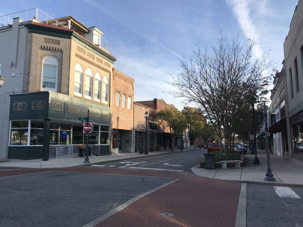
It’s not a long trip from these two towns in eastern North Carolina. This trip of less than 2 hours will merely be a leisurely Sunday drive (assuming the weather cooperates). We will cover 110 miles at an almost 63mph pace, and be in Fayetteville by lunch time. Let’s see what will happen.
Greenville, North Carolina
The tail of a continually weakening trough is bringing some showers and thunderstorms to the Tarheel state today, but guidance suggests the activity will be significantly weaker tomorrow morning thanks both to the fact that that trough IS weakening, and that we will be going in the morning, when the heat of the day will be absent. Indeed, this will be a leisurely drive! Stop for ice cream on the way, you have my permission.
We randomly pick our forecast cities, so there isn’t any favoritism here, but boy, our random selector sure seems to like Fayetteville lately.
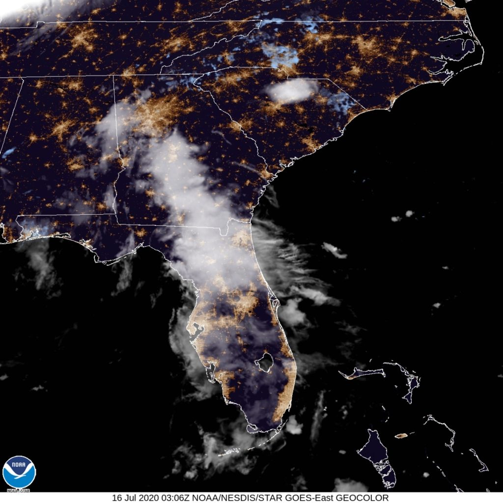
At 1053PM, ET, Fayetteville was reporting a temperature of 79 degrees with clear skies. With a dew point of 73, the clear skies are likely to lead to some fog developing before the night is through, though there was a spot of shower and thunderstorm activity southwest of Fayetteville across the border in South Carolina. A vast area of low pressure has parked itself over Hudson Bay, and is playing a role in directing traffic much further south. A weak undercutting wave moving through the southern Great Lakes is amplifying onshore flow in the eastern Carolinas tonight, but by tomorrow evening, only a fading trough west of the Appalachians will remain. A moisture rich, generally featureless landscape will mark the Carolinas’ atmosphere on Friday, with some later afternoon showers and thunderstorms possible, but likely closer to Charlotte and Winston-Salem, where the terrain may have some say in he matter. Hot and hazy is the name of the game in Fayetteville. Tomorrow – Partly cloudy and warm, High 92, Low 75 Friday – Mostly cloudy, High 94, Low 74
TWC: Tomorrow – Mostly sunny skies. High 92, Low 72 Friday – Sunshine and clouds mixed. A stray shower or thunderstorm is possible. High 93, Low 72
AW: Tomorrow – Partly sunny High 93, Low 71 Friday – A morning thunderstorm; otherwise, partly sunny High 93, Low 72
NWS: Tomorrow – A slight chance of showers and thunderstorms after noon. Mostly sunny High 94, Low 74 Friday – A slight chance of showers and thunderstorms after 1pm. Mostly sunny, High 95, Low 72
WB: Tomorrow – Partly sunny. A slight chance of showers and thunderstorms in the afternoon. High 90, Low 74 Friday – Mostly sunny High 90, Low 73
WN: Tomorrow – Partly cloudy, High 94, Low 78 Friday – Mostly sunny, High 95, Low 72
FIO: Tomorrow – Humid and partly cloudy throughout the day. High 92, Low 72 Friday – Humid and partly cloudy throughout the day. High 92, Low 70
Well, the day turned to Thursday as I was posting this, and that confused me a bit with the forecasts. Here is a look at the satellite, with one rogue shower, now fading, in South Carolina.
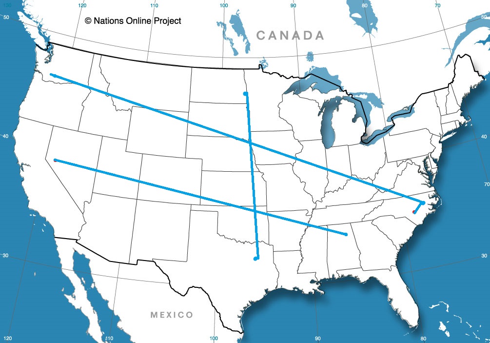
Are you ready for a lengthy trek cross country? We are heading from the northwesternmost state in the land to the eastern part of North Carolina, and will take us 5 days to make that trip. This is the perfect summer road trip, if you ask me. The mileage will hit 2810 miles, for a pace of about 67mph, with the first 4 days ending after about 535 miles, with a 10 hour day coming on Sunday. Let’s get to North Carolina by the end of the weekend, shall we?
DAY ONE (Wednesday)
Kennewick, Washington
Sometimes, in the eastern-US focused weather community, we forget that in the summer, that constant thunderstorm threat we are used to just doesn’t exist for a big part of the early summer. Such is the case this week in the Pacific Northwest. Quiet weather will allow us to take in the scenery from Washington, through Oregon and Idaho until we reach Howell, in the Utah panhandle.
DAY TWO (Thursday) The seasonal monsoon is preparing to develop in the southern Rockies, and indeed some guidance is pointing towards thunderstorms in the Colorado Rockies. Fortunately, we will not be traversing the Colorado Rockies, instead passing through Wyoming before ending up in Bushnell, in far western Nebraska. Rain is not expected to obscure our day.
DAY THREE (Friday) Nebraska us a long, arduous state to pass through by car, but if you like driving and identifiable benchmarks, then Nebraska is for you. We’re headed off the road for Nebraska City, then south through Iowa and Missouri, where we will stop in St. Joseph. Nebraska is going to be in fine shape. Lingering humidity will likely lead to morning fog, that I would hope will burn off by the time we reach St. Joseph.
DAY FOUR (Saturday) A slow moving, lingering trough extending into the Ohio Valley will make things a bit drearier on Saturday. By the time we reach southern Illinois, clouds with a stray sprinkle will become increasingly likely, with a rogue stroke of lightning not out of the questions. This will continue eastward, as we call it a day in Carefree, Indiana, which is west of Louisville.
DAY FIVE (Sunday) It’s just the time of year, but more wet weather will be possible on either side of the Appalachian range, but with low pressure developing in the Great Lakes, the better chance for rain or even a rogue thunderstorm will come up in eastern Kentucky and before we reach Charleston in West Virginia. There will be a healthy rain shadow in North Carolina, but we are headed far enough east, some oceanic flow will lead to isolated storms along the coast, including in Greenville, as we arrive, exhausted, at the end of our long day, at the end of our long trip.
Hurricane season usually peaks around early September, when the tropical seas are at their warmest. Last season, there were 8 storms that were ongoing in the month of September. That was a particularly active season, but that burst of storms happens when it usually does.
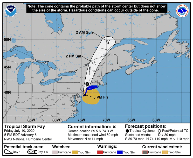
The storms started with Dorian and ended with Lorenzo (Erin came and went before September came around, while we all remember how long lived Dorian was) before all was said and done. Now, keeping in mind that it is only the 11th of July, note that the storm that clipped the mid-Atlantic this weekend was Tropical Storm Fay.
That means it was the 6th storm of the season, which didn’t come, even during last season’s intensity, until September. That’s a pretty remarkable thing. We usually don’t get to our F’s until at least late August, but the NHC has had to be particularly busy this year.
That sounds pretty dramatic, but check out this forecast map for Fay.
It was a shortwaved feature that didn’t last long, and wasn’t well organized until it had aid from the jet stream near the coast. The life span isn’t dissimilar from the rest of the storms of the 2020 season. The strongest storm of the season was Arthur, which had a 60mph max gust at his core.
In short, we have made it to July with 6 named storms, and none of them have become a hurricane. The NHC also does not have any areas being monitored for development into a tropical feature, which seems to suggest we are in the clear for a few days, at least.
Despite the brief areas of organization, this hasn’t been a terribly destructive early storm season. Sure, some of these bubbles have reached the lowest threshold to be named but nothing has approached the more significant threshold to be identified as a hurricane.
There hasn’t been a great deal of excess energy in the north Atlantic this season (in fact a fair bit less recently with that well advertised Sahara dust cloud muddling the skies), but continued improvement in monitoring and identification, as well as a slight aberration towards organization in the grand scheme of things, we have a lot of names already used, and the real meat of the season isn’t even here yet.
The Dakotas have been some of the stormiest states in the country lately, and we are on our way there! It’s a pretty straight shot from east Texas to the farthest east portion of North Dakota. The drive is a two day slog, covering 1086 miles at a pace of 64.7mph. Day one will be a hair shorter than day 2, concluding after 518 miles. It’s the weekend!
DAY ONE (Saturday)
Longview, Texas
The culprit behind some severe weather today in northern Nebreaska is a short little wave on the back side of a broader low in Quebec. Short little waves tend to move very quickly, as will this one, shifting out of the Dakotas towards the western Great Lakes. Through Texas and Oklahoma, expect a more laminar, westerly regime, which will mean hotter, dustier air for our Saturday. As the day concludes, though, some instability in eastern Kansas could lead to a stray rumble of thunder at the tail end of our day. The activity will be scattered in nature while hugging the Missouri border, and we may just as soon be dry all the way to Hoyt, north of Topeka, by the end of the day.
DAY TWO (Sunday) High pressure will nose in behind the system, bringing some seasonably more favorable temperatures to our drive. Low 80s in the eastern Dakotas instead of the mid 90s. I think we might appreciate that for a bit, especially after leaving Texas. I know the locals like it too. Fargo isn’t so bad in the middle of July.
Here we are, in the middle of road tripping season, and I think there are several people eager to get out on the open road. Let’s move around the country here in July.
Road Trip from Longview, Texas to Fargo, North Dakota
Road Trip from Kennewick, Washington to Greenville, North Carolina
Fayetteville, North Carolina Road Trip from Greenville to Fayetteville