We’re going to spend most of this 5 hour drive in Alabama, touching Montgomery and Mobile along the way. This pretty short drive will cover 327 miles at a pace of 64.1mph, which is also pretty reasonable for a short trip. All right, places to be, let’s go.
Columbus, Georgia
There is a strong area of low pressure in the Canadian Maritimes, and it is producing a cold front that is very active even in central Florida tonight. The boundary is reinforced by an area of low pressure emerging in the Gulf of Mexico. The increasing circulation will induce northerly winds in the southeastern US. While Florida will be particularly rainy, Alabama and it’s neighbors will be seasonably cool, with bright blue skies. It won’t even be humid in southern Mississippi when we arrive Sunday afternoon.
A business trip this week. Why a business trip? Because it will start on Monday and last through Thursday. Expect it to cover 2074 miles at a pace of a little more than 69mph, which will get us a healthy 553 miles a day for the first three days of our trek. And not to spoil anything, but the weather does look good.
DAY ONE (Monday)
San Luis Obispo, California
High pressure is back out there, everyone. it’s dominating the majority of the country this week, and the southwest US is no exception. The hardest part of the day will be leaving San Luis Obispo (because it’s so lovely) but we will arrive with no concerns at the Crookton Road exit, east of Seligman, Arizona.
DAY TWO (Tuesday) Nothing is really going to change on Tuesday, except for our location. We will see some rising and falling terrain, but not any real weather change. Heck, we’ll even be on I-40 the whole way. We’ll make it to Tucumcari, New Mexico, before this easy day concludes.
DAY THREE (Wednesday) Our good luck continues on Wednesday, as we spend much of the day in a calm, quiet Texas. The road will be clear, but be wary of traffic in Dallas, because it will have been a while since we saw any. The jet will start forming a kink south of Texas, and that can portend bad news for the atmosphere, but it won’t yet, not on Wednesday. We stop in Canton, Texas for one last pit stop.
DAY FOUR (Thursday) The trough will indeed start stirring up some wet weather, but it won’t emerge until after we are on our way into Mississippi. The rain will be over Mexico, low pressure in west Texas, and mostly sunny skies in Hattiesburg.
While the catastrophe in Texas has garnered many of the headlines this week, the disaster was more widespread than that. From cold weather throughout the Plains to snow and ice nearly everywhere west of the Appalachians, many people suffered loss, disruption and discomfort. In Hattiesburg, temperatures were significantly colder than normal, but at least late in the week, precipitation was all rain. There were even some rumbles of thunder on Wednesday night as the second feature of the weeklong event passed to the north. Ice was a huge problem to the north of Hattiesburg, and even with over an inch of rains, and temperatures in the 20s, before the precipitation rolled in, you might even say they were lucky. Victoria-Weather had the top forecast. Actuals: Wednesday – .93 inches of rain, High 42, Low 20 Thursday – .24 inches of rain, High 43, Low 32
Hattiesburg is among the many, many cities nation wide that is experiencing cold that they are wholly unaccustomed to. Particularly in the southern United States, record cold on top of a huge winter storm is working to exasperate the situation. Lets see if there is any hope for improvement for these next couple days.
At 653PM, CT, Hattiesburg was reporting cloud skies and a temperature of 23 degrees. The deep, strong, broad trough across the country is still holding firm to it’s place over the Plains. Another round of snow and ice is currently falling over the Red River Valley, getting ready to shift into a more moisture rich environment to the east. The wet weather will arrive in Mississippi towards afternoon tomorrow. The freezing line right now looks to slice just to the north of town, while enough warm air is expected to be drawn north to keep Hattiesburg in the rain overnight Wednesday into Thursday morning, though an ice storm is anticipated across the rest of Mississippi. The wavelength of the jet trough will contract after the storm has pushed to the east, and cold air will be able to dig south, leading to a chilly end of the week in Hattiesburg, but with the promise of some warmth soon after. Tomorrow – Rain, sometimes heavy and embedded with thunder late in the day. High 46, Low 20 Thursday – Rain early, then clearing and chilly, High 45, Low 33
TWC: Tomorrow – Partly cloudy in the morning then becoming cloudy with periods of rain later in the day. High 46, Low 21 Thursday – Showers in the morning, then cloudy in the afternoon. High 44, Low 37
AW: Tomorrow – Mostly cloudy and cold; a passing shower in the afternoon High 47, Low 19 Thursday – Occasional rain and drizzle in the morning; otherwise, mostly cloudy and cold High 42, Low 35
NWS: Tomorrow – Showers likely and possibly a thunderstorm, mainly after 4pm. Mostly cloudy, High 44, Low 23 Thursday – Rain and thunderstorms likely before 1pm, then a chance of rain. Cloudy, High 47, Low 36
WB: Tomorrow – Showers likely, and a chance of thunderstorms in the afternoon. Mostly cloudy. High 45, Low 20 Thursday – Light rain and thunderstorms likely in the morning then a chance of light rain in the afternoon. Cloudy. High 42, Low 36
WN: Tomorrow – Mostly cloudy with showers likely, High 44, Low 23 Thursday – Mostly cloudy with thunderstorms likely, High 47, Low 36
FIO: Tomorrow – Rain until night, starting again in the afternoon, High 46, Low 24 Thursday – Rain overnight and in the morning, High 49, Low 32
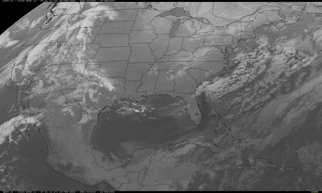
I’m not so sure about the threat for thunder. The system has a lot of juice, but I’m not sure there is enough instability in the region. Still, there is going to be a healthy dousing of rain, perhaps over a half inch. If that all freezes on contact to the north, it could be a scary situation from Jackson north towards Memphis and Tupelo. This is a big time system. Here is the next round of wet weather on satellite over the Red River Valley.
NOAA/NESDIS/STAR GOES ABI BAND 14 OR_ABI-L1b-RadC-M6C14_G16_s20210480131035_e20210480133407_c20210480133535.nc
To start the month of March, we were monitoring the forecast in Hattiesburg, Mississippi. There wasn’t much to it, honestly, with high pressure over the region and — wait, light rain overnight? I call shenanigans. Actually, specifically, I call out the tendency for the ASOS in the Hattiesburg office for suggesting mist when there often isn’t any. It tends to fog in pretty severely in Hattiesburg, but the actual condensate is harder to verify as legitimate precipitation. I digress. Nobody had , true or not, in the forecast, so we can comfortably say that Victoria-Weather collected the victory. Actuals: Saturday – High 71, Low 31 Sunday – High 71, Low 39
I will admit, that I haven’t done a heck of a lot of driving in the southeastern US, so I don’t have a terribly good concept of just how big the spaces are down there. I am a little surprised, I guess is what I am saying, that Deltona and Hattiesburg are only 610 miles apart, and the drive can be done in just one day. The pace will be a brisk 70mph, owing the fact, I guess, that the only major towns we will bypass are Tallahassee and Mobile, which I guess aren’t beset by traffic.
Deltona, Florida
The weather in Deltona today is quite nice, and there really isn’t anything on its way that suggests that will change for the next 24 hours or so. TYhe start of our drive, therefore, looks pretty great, pretty swift and incident free. Unfrotunately, an area of low pressure developing over Ontario, of all places, is draping a cold front south along the Mississippi River, and it will be inching into the Tennessee Valley as we get going on Monday. Now, the cold front will not reach the coast or I-10 at any point, but the flow feeding the boundary will lead to some afternoon showers and storms from the Florida Peninsula west to Hattiesburg. The shower activity is most possible beyond Tallahassee, but doesn’t become likely until we reach Mobile. The rain won’t last all night, so Hattiesburg should dry up by nightfall. Of course if we want to spend any more time in Hattiesburg than just one night, we might need to make sure our plans are of the “indoor” variety.
Hattiesburg is a part of the Jackson WFO, and in my opinion, this is the best Forecast Office in the country. That aside, let’s see if they are as good at forecasting as they are at web design.
At 1253AM, CT, Hattiesburg was reporting a temperature of 37 degrees with clear skies. The remnants of a strong system are continuing to clear out of the Ohio VAlley, but otherwise, the satellite remains clear east of the Rockies with a surface ridge building from the Gulf to the Great Lakes. There continues to be a broad upper level trough, with the base running zonally along the US-Mexican border the northern Gulf, with an undercutting ridge providing the stability over the continental US. The base of the trough being as far south as it is simply for temperatures to remain a bit below normal, though the clear skies will help make up some of the difference in the afternoon. Tomorrow – Sunny, High 70, Low 34 Sunday – Partly cloudy, High 73, Low 42
TWC: Tomorrow – Generally sunny despite a few afternoon clouds. 71, Sunday – Partly cloudy skies. High 70, Low 44
AW: Tomorrow – Abundant sunshine, High 69, Low 36 Sunday – Partial sunshine High 70, Low 42
NWS: Tomorrow – Sunny, High 69, Low 37 Sunday – Mostly sunny High 71, Low 42
WB: Tomorrow – Sunny, High 69, Low 38 Sunday – Mostly sunny im the morning, then becoming partly cloudy, High 69, Low 44
It seems like these two towns should be nearer to one another, but in fact, it’s a day and a half drive between Miami, way at the south end of Florida, and Hattiesburg. To give you an idea of how big Florida is, our drive covers 817 miles in total, and probably 3/4ths of it are in the Sunshine State. We will do 2/3rds of the driving on day one, which will account for 542 miles at the Floridian pace of 67.8mph, It’s a long ways from Miami to any other state, so be patient.
DAY ONE (Saturday)
Miami, Florida
A long, dangling front extends from a low over Newfoundland. If that gives you any idea, by the time the front has reached north Florida, it is quite weak, and as we drive north, it may only bring a few clouds over Orlando. North and west from the Ocala and Gainesville area, however, we will probably note a change in the air. Somewhat cooler air is possible, but more significantly, it will feel drier than Miami. We’ll make it to Grand Ridge in the Panhandle to call our day complete.
DAY TWO (Sunday) High pressure is developing over the East Coast this weekend, and guidance is suggesting that the return flow will be strongest in the Mobile area. There might be some light rain showers as a result, but more likely, it will just be some puffy cumulus clouds. Hattiesburg won’t have to deal with any of that, but the afternoon will be getting warmer and soupier after we arrive.
We’ll touch upon the storms that have swept through the south, in particular east Texas and the Lower Mississippi Valley soon, but in a less important note, gosh darn it it rained in Hattiesburg on Tuesday morning. It wasn’t much. Nobody noticed it because it was so brief and pre-dawn, but forever on the record it will say it rained on Tuesday April 9th, 2019, and nobody will remember it or acknowledge it, because it was a trace of rain in a week that saw the area get pummeled by more concerted rounds of stormy conditions. on Monday and then again over the weekend. All of these complaints are to say that Victoria-Weather didn’t do greater with the forecast. The National Weather Service and WeatherNation did, however, winning the day. Actual: Tuesday -Trace of rain, High 81, Low 62 Wednesday – High 82, Low 56
After a quiet weekend, we are jumping back into the world of forecasting. Another big storm looms here in mid April, which is fine alongthe Gulf Coast, and might even be a little fun. Don’t ask about what it’s like up north.
At 753PM, CT, Hattiesburg was reporting a temperature of 72 degrees and overcast skies. Central Mississippi was seeing an active weather night, as a clearly evident vorticity maximum centered southeast of Brandon was drawing a band of thunderstorms along I-59, however the southern end was pulling northeast and away from town. The air in the southeast is juicy and unstable, but the trough parenting this hit of low pressure has little upper level support and a lot of forward momentum. Expect a quiet night in Hattiesburg. And so it will be on Tuesday and Wednesday as upper level high pressure follows into Mississippi. Expect a brisk warm up on Wednesday as a beast of a system develops in the central Plains and taps into the Gulf of Mexico for moisture. Tomorrow – Mostly sunny, High 77, Low 63 Wednesday – Partly cloudy, warmer and more humid, High 85, Low 57
TWC: Tomorrow – A shower or two around the area in the morning, then partly cloudy in the afternoon. Thunder possible High 80, Low 61 Wednesday- A mainly sunny sky. High 86, Low 55
AW: Tomorrow – A passing morning shower; otherwise, mostly cloudy High 79, Low 63 Wednesday – Plenty of sunshine; warmer High 86, Low 54
NWS: Tomorrow – A 20 percent chance of showers before 10am. Cloudy, then gradually becoming mostly sunny, High 81, Low 62 Wednesday – Sunny High 84, Low 56
WB: Tomorrow – Mostly cloudy with a 20 percent chance of showers in the morning High 78, Low 63 Wednesday – Sunny, high 85, Low 55
WN: Tomorrow – Partly cloudy with isolated showers, High 81, Low 62 Wednesday – Sunny, High 84, Low 56
FIO: Tomorrow – Mostly cloudy until afternoon. High 80, Low 63 Wednesday – Clear throughout the day. High 86, Low 56
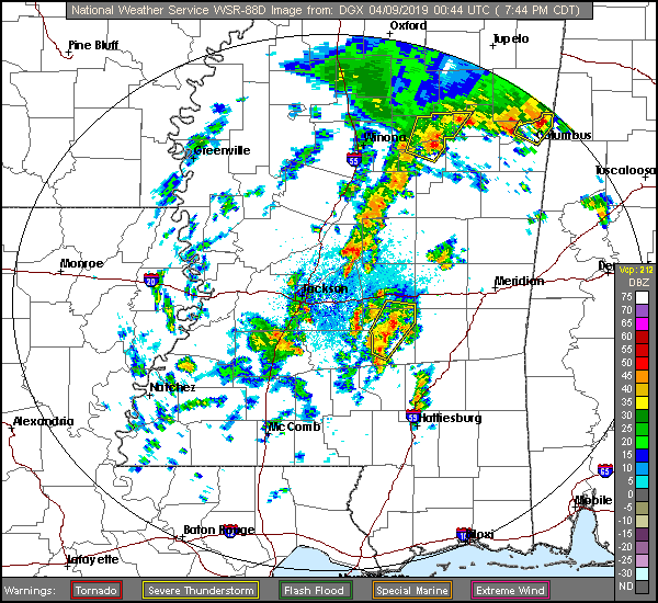
First, check out the radar, and the low pressure evident even on this map.
Now let’s check in with WJTV from Mississippi for the Pine Belt forecast.