Our forecast for Utica fell over the Independence Day holiday, and called for a warming trend that would ultimately approach 90 on Friday. While it was a few degrees from 90 on Friday, it was actually warmer on the 4th than it was on the 5th. There was a splash of rain in the morning, but not enough to alter anyone’s plans, so trips to the lake, runs through the sprinkler, or any sort of deck or patio based activities were on. Everyone had the 5th as the warmer day, so WeatherNation being among the warmer forecasts on the 4th and cooler forecasts on the 5th ended up claiming a victory. Actuals: Thursday – .01 inches of rain, High 87, Low 70 Friday – High 85, Low 69
I once had a job where I would issue forecasts regularly for Tunica, Mississippi. It has nothing in common with Utica, except Tunica’s identifier is KUTA, and I had a coworker who regularly called Tunica “Utica”, and that is all I can think of when I think of Utica. I’m sorry, Utica.
At 353PM, ET, Utica was reporting a temperature of 86 degrees and clear skies. Accompanying this warmth and sunshine was a brisk southerly well, importing still more warm air from the southeast. Low pressure is occluded and winding down over James Bay, but is still allowing for the vigorous southerly flow through western New York. Associated showers and storms won’t enjoy the instability they are seeing in southern Ontario right now, but a stray overnight shower in Utica seems likely. The evening of Independence Day tomorrow looks OK for fireworks. Orphaned moisture in the mid-Atlantic as the low moves from James Bay to Nunavut will linger and ensure some mid level clouds with light winds. Much of the day will be clear on Friday as well, with a return of warm south winds. The next feature will be emerging in the Upper Midwest through this time, and will bring a more likely shot of rain late on Friday. Tomorrow – Early showers, then mostly cloudy, High 83, Low 69 Friday – Sunny early with a late shower, High 88, Low 62
TWC: Tomorrow – Rain showers early with mostly cloudy conditions later in the day. High 86, Low 70 Friday – Intervals of clouds and sunshine. A stray shower or thunderstorm is possible High 88, Low 63
AW: Tomorrow – A passing shower in the morning; otherwise, very warm and humid with intervals of clouds and sunshine High 86, Low 67 Friday – Very warm and humid with variable cloudiness; a thunderstorm in the afternoon High 88, Low 62
NWS: Tomorrow – A slight chance of showers and thunderstorms between 9am and 11am. Mostly cloudy, High 87, Low 69 Friday – A slight chance of showers between 2pm and 5pm, then a slight chance of showers and thunderstorms after 5pm. Mostly sunny, High 89, Low 65
WB: Tomorrow – Mostly cloudy with a chance of showers with a slight chance of thunderstorms in the morning, then partly sunny in the afternoon, High 83, Low 67 Friday – Partly sunny (late rain), High 88, Low 65
WN: Tomorrow – Partly cloudy with light rain showers and isolated storms, High 86, Low 69 Friday – Partly cloudy with isolated showers and isolated storms, High 88, Low 66
CLI: Tomorrow – Light rain showers, High 83, Low 67 Friday – Mostly cloudy, High 87, Low 63
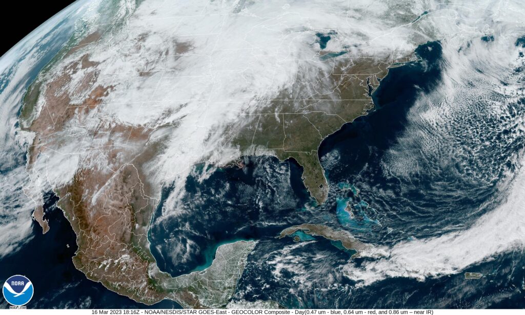
It looks like a warm start to the holiday weekend in western New York. I hope there and everywhere stays healthy and happy, while saying a little prayer for residents of the West Indies and Jamaica, who will spend the time recovering from Hurricane Beryl. As for the Mid-Atlantic, the satellite is more ominous than the forecast portends.
An important part of the winter cycle in the north is the storage of water in the snowpack that will sustain and help nourish the first buds of spring time. It has been a warm, dry winter in the mid-Atlantic, so the next best thing is rain, like what fell on St. Patrick’s day in Utica. They received over a half an inch of rain, with a mostly inconsequential spot of flurry activity on the Saturday after. Usually the rainy systems with changing precip types are calamitous in the temperature forecast, but perhaps with a bit of the luck of the Irish, forecasts were quite good all around. The National Weather Service gained the W. Actuals: March 17th, .58 inches of rain, High 45, Low 32 March 18th, .05 inches of liquid in snow, High 38, Low 25
On this, the first day of the round of 64 in the NCAA tournament, we go to Utica, a town that sure sounds like a college town. Alas, they are not home to any Division 1 universities, but they are situated in the scenic Adirondacks.
At 153PM, ET, Utica/Rome was reporting a temperature of 43 degrees with overcast skies. The temperatures have bounced back nicely in the wake of the first real nor’easter of the season, however the climb in temperatures is aided by another system developing in the Mississippi Valley. Southerly winds will continue through the mid Atlantic today, bringing even more warm air to Utica, continuing what has been a very toasty winter season, though at this point in the year, and this system in particular are quite spring like. The storm is responsible for severe weather in the Red River Valley that will become more widespread this afternoon. Of more pertinence to the Utica region is the sloppy mix in the Northern Plains. As most systems do, this feature is starting its poleward motion, and at this time even the northern flank of this feature is mixing with rain. This suggests that warmer air will pull further north, and as the system moves through, Utica can expect an all rain event tomorrow. The rain will be fairly light with a dry slot nosing into the Adirondacks, and temperatures will fall off on Saturday as the cold air arrives. By that point, most of the moisture will have pressed into Canada, and a chilly breeze will be more noticeable than the few flakes in the evening. Tomorrow – Scattered showers, High 44, Low 32 Saturday – Chilly and breezy with a little bit of flurry activity late, High 35, Low 24
TWC: Tomorrow – Rain, High 45, Low 30 Saturday- Mostly cloudy. Snow showers around in the afternoon. High 37, Low 30
AW: Tomorrow – Periods of rain, High 47, Low 32 Saturday – Mostly cloudy with a couple of snow showers; any heavy snow shower could cover the ground quickly and reduce visibility High 40, Low 26
NWS: Tomorrow – Showers, mainly after 9am High 45, Low 31 Saturday – A chance of snow showers after 3pm High 37, Low 25
WB: Tomorrow – Rain showers with freezing rain likely in the morning with rain showers in the afternoon, High 42, Low 32 Saturday – Partly sunny in the morning then becoming mostly cloudy. A 40% chance of snow showers, High 36, Low 24
WN: Tomorrow – Mostly cloudy with showers, High 45, Low 31 Saturday – Windy with snow showers possible, High 35, Low 29
CLI: Tomorrow – Drizzle, High 45, Low 32 Saturday – Light snow, High 39, Low 23
More wet weather is on the way for Utica. It seems pretty ok for now, but the next feature looms.
Snow was reported sporadically for the first 36 hours of the forecast period in Utica. The grand total accumulation was about 2 hundredths of an inch of precipitation, which is probably less than half an inch of true accumulation. Downwind of the Great Lakes, that practically qualifies as a no snow day. Temperatures were a challenge, cooling more than expected on Saturday. Ultimately, Victoria-Weather continued our winning streak. Actuals: Friday, Snow reported, not measured. High 28, Low 21 Saturday – .02 inches of snow, High 28, Low 7
It’s been a big weather week in the southern US, and all that activity is moving the north-northeast. At least Utica is accustomed to big snow, in case that is what is on the way.
At 153PM, ET, Utica was reporting a temperature of 25 degrees with overcast skies. The low pressure that has been bringing so much pain and heart break to the southern US has shifted predominantly off shore, but an inverted trough is pointed through New Jersey towards Binghamton. Light snow was falling across the Poconos and was headed towards Utica. Snow will continue in the area as low pressure becomes distended perpendicularly across the Gulf Stream. The cold front will stall, and so too will the inverted trough across New York. Light snow showers are going to continue in Utica at least through the day tomorrow as reorganization begins in the southeastern US. Troughing will be tilted aloft, which will be conducive to further cyclogenesis. The reborn feature will get stronger tomorrow night into Saturday morning. The feature will shift into the North Atlantic and drag wet weather along with it. Late Saturday will be cool but dry. Tomorrow – Snow likely all day, High 30, Low 19 Saturday – Some early snow, then clearing and cold, High 26, Low 17
TWC: Tomorrow – Variable clouds with snow showers High 32, Low 21 Saturday – Overcast. A few flurries or snow showers possible. High 27, Low 19
AW: Tomorrow – Periods of snow, accumulating 1-3 inches; storm total snowfall 3-6 inches High 33, Low 24 Saturday – Remaining cloudy and breezy with a couple of flurries High 30, Low 24
NWS: Tomorrow – Periods of snow, mainly before 1pm, then scattered snow showers after 2pm High 32, Low 20 Saturday – A chance of snow showers. Mostly cloudy High 27, Low 18
WB: Tomorrow – Snow. Total snow accumulation of 2 to 4 inches. High 32, Low 22 Saturday – Mostly cloudy with a 50 percent chance of snow showers. High 28, Low 22
WN: Tomorrow – Cloudy with light snow likely, High 32, Low 20 Saturday – Mostly cloudy with chance of light snow showers, High 27, Low 18
FIO: Tomorrow – Foggy throughout the day. High 35, Low 22 Saturday – Foggy overnight and in the morning. High 28, Low 18
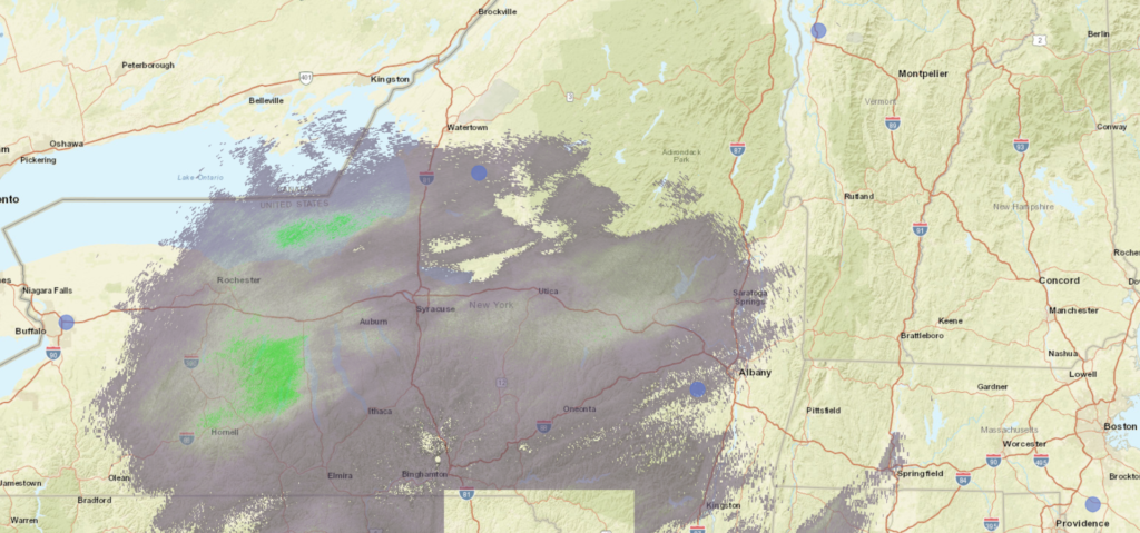
It’s going to be a smattering of snow across the region, which will last for quite a while, and thankfully not a big storm like they saw in the south, or really like they can see with a lake effect feature. Here is the radar right now, with a lot of coverage, but not much heavy precipitation.
Utica got the slightest bit of rain Monday morning as dissipating activity gave the city just enough to nudge the rain gauge. The rest of the day and Tuesday was fairly pleasant, though the morning lows were a smidge lower than most expected. Us here at VW anticipated that, however, and rode those cooler morning lows to an easy victory.
Monday: 0.01″ in a morning shower. High 82, Low 64.
Tuesday: High 82, Low 57.
Forecast Grade: A
Today we’re heading to Central NY and taking a closer look at Utica, NY to start the workweek.
At 1153pm EDT, the temperature at Utica, NY (officially nearby Griffiss AFB) was 68 degrees with a few clouds. The tail end of a cold front is shifting its way through the Northeast, and with it showers and thunderstorms are moving through the Great Lakes. While thunderstorm activity should be winding down by the time activity moves through, there could still be a cell or two that affects the region. Otherwise, general rain showers are anticipated before conditions clear out for the afternoon. High pressure shifts in for Tuesday and brings with it sunnier skies and pleasant conditions!
Monday: Morning rain/possible storm, clearing late. High 83, Low 65.
Tuesday: Mostly sunny. High 81, Low 57.
TWC: Monday: Scattered thunderstorms. High 83, Low 67.
Tuesday: Mostly sunny. High 84, Low 59.
AW: Monday: A shower or tstorm in spots. High 84, Low 68.
Tuesday: Mostly sunny; less humid. High 83, Low 62.
NWS: Monday: Showers then slight chance of storms. High 85, Low 66.
Tuesday: Mostly sunny then slight chance of showers. High 83, Low 61.
WB: Monday: Chance of thunderstorms. High 81, Low 69.
Tuesday: Partly sunny. High 81, Low 59.
WN: Monday: Partly cloudy with light showers. High 86, Low 67.
Tuesday: Partly cloudy with isolated showers. High 85, Low 63.
FIO: Monday: Morning rain then partly cloudy. High 83, Low 67.
Tuesday: Partly cloudy throughout the day. high 85, Low 60.
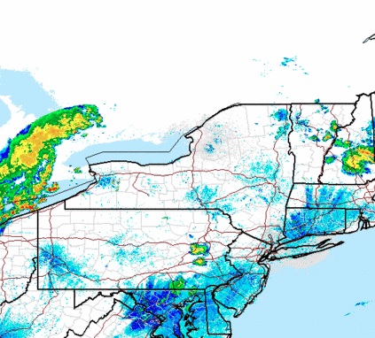
The Utica area is quiet currently, but storms off to the west will be approaching through the morning hours.