Springfield, Massachusetts

Only a fortnight left of shopping until Christmas! What will the weather be like in Springfield, MA as we head into the weekend to get those gifts?

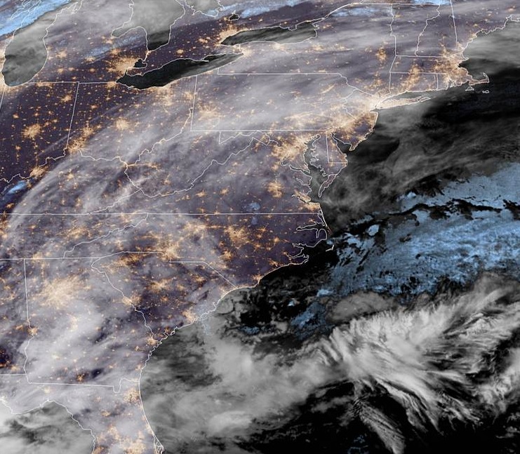
At 1156pm EST, the temperature at Springfield, MA was 20 degrees under fair skies. High pressure is found over New England currently, but the next couple of days will see conditions deteriorate rapidly. An area of low pressure is developing in the Southeast and will scoot its way up the Eastern Seaboard throughout the day Friday. Rain showers will shift into the area by the evening hours, and increase in intensity overnight into Saturday as the low draws closer to the region. Some heavy rains are expected Saturday morning and should finally taper off some during the afternoon and early evening hours as the low shifts through New England. Winds are expected to pick up late Saturday as well, making for a rather miserable start to the weekend.

Friday: Increasing evening showers. High 40, Low 21.
Saturday: Heavy morning rains, becoming lighter in evening. High 52, Low 40.

TWC: Friday: Afternoon rain showers. High 39, Low 20.
Saturday: Rain. High 52, Low 37.

AW: Friday: A bit of afternoon rain. High 37, Low 21.
Saturday: Heavy rain tapering off. High 50, Low 35.

NWS: Friday: Mostly cloudy then chance of wintry mix. High 35, Low 20.
Saturday: Heavy rain, areas of fog. High 42, Low 35.

WB: Friday: Chance of rain showers. High 38, Low 20.
Saturday: Rain. High 53, Low 38.

WN: Friday: Cloudy with light showers likely. High 38, Low 20.
Saturday: Cloudy with light rain. High 50, Low 35.

FIO: Friday: Light rain starting in afternoon. High 43, Low 23.
Saturday: Rain until evening. High 56, Low 42.

Some high clouds are streaming over the area currently, but the system taking shape in the Southeast is what will bring our weekend rains.

Pittsburgh, Pennsylvania

Whoops! This was supposed to be posted on Monday evening. However, something from Real Life Inc. interfered and even though the data had already been gathered, I forgot to disperse it to our faithful readers! Apologies! I’ll understand if I get one fewer present under the tree.

At 951pm EST, the temperature at Pittsburgh, PA (KPIT) was 56 degrees with light rain falling. As a cold front is pushing through the region, a few straggling showers are expected over the area early Tuesday morning, but then conditions clear out by midday as high pressure works in behind the system. Wednesday should be dry, but much colder as high pressure shifts overhead.

Tuesday: A few morning showers. High 53, Low 27.
Wednesday: Clearing and colder. High 34, Low 21.

TWC: Tuesday: Cloudy, chance of morning showers. High 57, Low 31.
Wednesday: Mostly sunny. High 34, Low 20.

AW: Tuesday: Cooler, a shower in the morning. High 54, Low 30.
Wednesday: Partly sunny and colder. High 35, Low 22.

NWS: Tuesday: Chance of morning rain showers. High 55, Low 30.
Wednesday: Mostly sunny. High 32, Low 20.

WB: Tuesday: Chance of morning rain showers. High 55, Low 30.
Wednesday: Mostly sunny. High 32, Low 24.

WN: Tuesday: A few morning showers. High 54, Low 29.
Wednesday: Mostly sunny. High 33, Low 21.

FIO: Tuesday: Light rain in the morning. High 58, Low 30.
Wednesday: Clear throughout the day. High 33, Low 24.

Cleveland, Ohio

Tonight we head to the Great Lakes where we visit a city that is the site of my favorite sporting moment in my life so far… the Cubs winning the World Series! Sorry Cleveland, but you had already won the NBA title that year.

At 1153pm EST, the temperature in Cleveland, OH was 51 degrees with some light rain occurring. A cold front is pushing through the Great Lakes tonight with some light rain showers pushing through the Cleveland area. These showers will persist into the pre-dawn hours before shifting eastward. Dry weather and decreasing clouds will seem more pleasant for the daytime hours, but a breezy northwest wind will continue to usher in colder air throughout the day, leading to a midnight high and only a daytime high in the upper 30s. Weak high pressure will traverse the area Friday evening into Saturday morning with mostly clear skies. However, this will be short-lived as a low-pressure system develops over the Lower MS-River Valley and shifts northeastward. While the bulk of the system will miss off to the east, some rain showers on the northwestern side of the low look to wraparound and impact the city on Saturday evening. Nothing too heavy, just enough to annoy every that’s out having fun on their weekend.

Friday: A few early morning showers, decreasing afternoon clouds with temperatures dropping. High 51, Low 32.
Saturday: Increasing clouds, a couple late evening showers possible. High 45, Low 29.

TWC: Friday: Early rain, then partly cloudy/windy. High 43, Low 35.
Saturday: Afternoon showers. High 45, Low 30.

AW: Friday: Some sun returning; cooler. High 52, Low 35.
Saturday: Occasional afternoon rain. High 44, Low 30.

NWS: Friday: A few early morning showers, then breezy and mostly sunny. High 41, Low 33.
Saturday: Partly sunny, chance of rain. High 46, Low 30.

WB: Friday: Chance of early morning rain, then partly cloudy. High 52, Low 33.
Saturday: Chance of rain. High 44, Low 31.

WN: Friday: Slight chance of morning shower, then partly cloudy. High 53, Low 33.
Saturday: Partly cloudy with scattered showers. High 46, Low 31.

FIO: Friday: Drizzle tonight. High 52, Low 32.
Saturday: Mostly cloudy throughout the day. High 45, Low 28.

A few rain showers are traversing the region currently, but the rest of the day should be dry!

Tulsa, Oklahoma

Tonight we head to the Southern Plains to see how Tulsa is setting up for the rest of the workweek. Will the Golden Hurricanes of the namesake university see a peaceful couple of days? Or is there a tempest brewing?

At 1053pm CST, the temperature at Tulsa, OK was 63 degrees under partly cloudy skies. An area of low pressure is working through the Midwest, trailing a cold front through the Southern Plains that will bring rain showers and a few scattered thunderstorms during the day. However, temperatures will be falling throughout the day as cooler air works in from the morning as high pressure works down into the Northern Plains. As the boundary continues to push south Thursday into Friday morning, a few lingering rain showers are anticipated over the region, though the heaviest activity looks to be off to the east. Conditions should dry up as the day goes on, but even cooler temps will work their way into the state as high pressure pushes further south over the Central Plains.

Thursday: Chances of showers and thunderstorms. High 62, Low 42.
Friday: Widespread showers. High 41, Low 34.

TWC: Thursday: Rain. High 65, Low 44.
Friday: Showers. High 44, Low 34.

AW: Thursday: A shower in the morning. High 65, Low 45.
Friday: Occasional morning rain. High 44, Low 35.

NWS: Thursday: Chance of showers then thunderstorms. High 63, Low 45.
Friday: Showers then chance of thunderstorms. High 45, Low 36.

WB: Thursday: Rain showers expected. High 63, Low 45.
Friday: Morning rain showers. High 45, Low 35.

WN: Thursday: Mostly cloudy with isolated storms. High 63, Low 45.
Friday: Mostly cloudy with scattered showers. High 44, Low 37.

FIO: Thursday: Light rain starting later tonight. High 66, Low 44.
Friday: Possible light rain until afternoon. High 45, Low 36.

Some decent rain showers are found east of the city and pushing towards Joplin. Another couple rounds of precip are in the cards for the rest of the workweek however.

Dodging Bullets in Winchester

Some light rain showers were found in the Winchester area on late Monday evening. But luckily, for the residents however, the city avoided the rain and stayed dry through the forecast period. Temperatures warmed nicely for Tuesday as expected, though Monday’s highs never quite got as high as anybody wanted. Weatherbug narrowly edged out the competition for the win

Monday: High 39, Low 34.
Tuesday: High 50, Low 35.
Forecast Grade: C

Winchester, Virginia

Today we head to Winchester, VA and see how they’re going to start the new workweek.

At 1115pm EST, the temperature at Winchester, VA was 36 degrees under overcast skies. A large area of low pressure is sitting offshore off the Carolinas and looks to shift northeastward over the next 24 hours, bringing coastal rains to New England and some light snow further inland. A weak area of low pressure is shifting through the OH Valley currently and while its expected to mainly dissipate as it shifts into the Mid-Atlantic. A mid-level disturbance, however, could kick up some afternoon/evening rain showers in the area tomorrow before shifting out to sea itself. While another trough looks to swing through the region on Tuesday, it won’t be very strong and no precip is anticipated.

Monday: Mostly cloudy, an isolated evening shower possible. High 44, Low 33.
Tuesday: Mostly cloudy. High 49, Low 32.

TWC: Monday: Cloudy. High 45, Low 33.
Tuesday: Mostly cloudy. High 52, Low 31.

AW: Monday: Mostly cloudy, isolated shower possible. High 45, Low 33.
Tuesday: Times of clouds and sun. High 50, Low 33.

NWS: Monday: Cloudy then slight chance of afternoon/evening showers. High 46, Low 34.
Tuesday: Partly sunny. High 51, Low 34.

WB: Monday: Mostly cloudy, chance of evening rain showers. High 44, Low 34.
Tuesday: Partly sunny. High 50, Low 32.

WN: Monday: Mostly cloudy with isolated showers. High 46, Low 34.
Tuesday: Partly cloudy. High 51, Low 34.

FIO: Monday: Overcast throughout the day, late shower possible. High 47, Low 33.
Tuesday: Mostly cloudy throughout the day. High 51, Low 29.

Not much going on in Virginia tonight, but some light shower activity over the OH Valley will be shifting through the region over the next day or so.

San Luis Obispo, California

Today we take a trip to the Southwest, where the big story the last few days have been unrelenting Santa Ana winds and massive brush fires kicking up from Sacramento to Los Angeles. Will San Luis Obispo be spared from nature’s fury as we head into the weekend?

At 950pm PDT, the temperature at San Luis Obispo, CA was 46 degrees under fair skies. High pressure continues to settle in from the Northern Rockies into the Central High Plains, keeping pretty much the entire Western US dry as a bone. Luckily, the Santa Ana’s will be weakening tomorrow after an intense event the last 3 days, which caused the Los Angeles NWS office to issue an Extreme Red Flag Warning, something that’s not in their official lexicon but they needed to convey the danger that 60-80mph winds an 1-5% humidity can cause. While a number of fires popped up, SLB avoided the worst of it, save for some air quality issues. Friday is expected to see some breezy conditions in the morning but settle down throughout the afternoon hours. After that, it looks to be a fairly pleasant weekend with generally subdued winds.

Friday: Sunny. High 81, Low 41.
Saturday: Sunny. High 79, Low 40.

TWC: Friday: Sunny. High 80, Low 43.
Saturday: Sunny. High 80, Low 41.

AW: Friday: Sunny and pleasant. High 80, Low 40.
Saturday: Sunny and pleasant. High 80, Low 38.

NWS: Friday: Sunny and breezy. High 80, Low 41.
Saturday: Sunny. High 78, Low 42.

WB: Friday: Sunny. High 79, Low 42.
Saturday: Sunny. High 80, Low 42.

WN: Friday: Sunny. High 80, Low 41.
Saturday: Sunny. High 78, Low 42.

FIO: Friday: Clear throughout the day. High 78, Low 47.
Saturday: Clear throughout the day. High 79, Low 50.

The Desert Southwest is pretty much clear as clear can be. The nearest significant cloud system is in the Northern Plains.

Olympia, Washington

Today we’re going to visit the Pacific Northwest, and visit the capital of Washington! Let’s see how Olympia will fare as we head into midweek.

At 654pm, the temperature at Olympia, WA is 51 degrees under fair skies. An area of low pressure is intensifying over eastern Montana, and trailing a front back through ID into OR. This feature will be pushing out into the Plains throughout the day Wednesday, bringing some showers to the Central Plains. Behind this feature, an area of high pressure is settling in over the Pacific Northwest and looks to make it its home over the next couple of days. Some areas of dense fog are possible in the area tomorrow morning before burning off by midday. Some patchy fog is possible Thursday morning too, but will be less widespread. Both days will be dry, with temps lifting a smidge for Thursday.

Wednesday: Some morning dense fog, then becomes sunny. High 58, Low 41.
Thursday: Partly cloudy and a bit warmer. High 61, Low 37.

TWC: Wednesday: AM fog, PM sun. High 59, Low 43.
Thursday: Morning fog again, then afternoon sun. High 62, Low 41.

AW: Wednesday: Times of clouds and sun. High 58, Low 41.
Thursday: Mostly sunny and pleasant. High 62, Low 38.

NWS: Wednesday: Patchy fog then sunny. High 57, Low 42.
Thursday: Mostly sunny. High 62, Low 41.

WB: Wednesday: Partly sunny. High 56, Low 46.
Thursday: Mostly sunny. High 60, Low 42.

WN: Wednesday: Mostly sunny. High 57, Low 42.
Thursday: Partly cloudy. high 62, Low 41.

FIO: Wednesday: Partly cloudy throughout the day. High 58, Low 40.
Thursday: Mostly cloudy throughout the morning, clearing late. High 61, Low 37.

A bunch of high clouds are streaming over the area as a system gets revved up in the Northern High Plains. High pressure takes over the region keeping conditions fairly pleasant.

Lewiston, Maine

As the Northern Plains get pummeled by a historic early-season blizzard, we’re going to take a look at a locale that would probably bring visions of snow and crisp air to the mind, Lewiston, Maine! Surely they’re doing better than our neighbors in the Dakotas, right?

At 1056pm EDT, the temperature at Lewiston, ME was 51 degrees under fair skies. While a potent winter storm hits the Central US, a nor’easter is busy spinning its’ wheels off the Eastern Seaboard. It’s been pushing plenty of rain into Southern New England over the last 24 hours along with persistent northeasterly winds, causing coastal flooding in areas. While some shower activity may get close to the coast during the day Friday, we’re expecting the Lewiston area to remain dry. As the low finally gets moving towards Nova Scotia, some light shower activity may affect the area early Saturday morning before drying out for the rest of the day. It may not be a washout, but overall, not a great start to the weekend weather-wise.

Friday: Overcast. High 58, Low 43.
Saturday: Cooler with scattered morning showers. High 54, Low 43.

NWS: Friday: Overcast. High 57, Low 44.
Saturday: Showers expected. High 53, Low 46.

AW: Friday: Rather cloudy. High 57, Low 43.
Saturday: Rain and drizzle in the morning. High 51, Low 44.

NWS: Friday: Mostly cloudy, couple of late showers. High 58, Low 43.
Saturday: Scattered showers. High 53, Low 43.

WB: Friday: Mostly cloudy. High 55, Low 44.
Saturday: Scattered showers in morning. High 53, Low 46.

WN: Friday: Mostly cloudy, showers late. High 58, Low 43.
Saturday: Mostly cloudy with scattered showers. High 53, Low 43.

FIO: Friday: Mostly cloudy throughout the day. High 61, Low 45.
Saturday: Possible drizzle in the morning. High 55, Low 48.

The Lewiston area is dry currently, but those rain showers sitting offshore will slowly rotate their way inland during the weekend.

S(n)o(w) It Begins…

It’s a beautiful day here at VW HQ, temperatures in the low 70s, dew pts in the upper 30s, breeze is a bit stronger than I care to enjoy but I wont complain. Tomorrow looks to be just as enjoyable as well around here. This lovely weather should totally go on for the indefinite future as we head deeper into OctOH MY GOD… checks models

Currently there’s an area of low pressure off the East Coast and over the next couple of days, looks like it will sit just off southern New England and focus a ton of rain right at RI, CT, MA. Strong high pressure sits over Southeast Canada and extends through the Great Lakes all the way down to the TN Valley. What this is doing is causing a blocking pattern and as low pressure ejects out into the Plains late Wednesday into Thursday, it has nowhere to go but basically north-northeast, from eastern KS to MN/WI. Given the cold air that will work its way in on the backside of this system as well, it’s shaping up to possibly produce quite the snowfall from western Nebraska/eastern Wyoming northward through the Dakotas. While it’s a bit early to pin down where the highest snowfall will happen, the Central Dakotas have the highest chance of seeing 6-12″ of snow and combine with winds of 25-35mph. One interesting thing to note is that the top analog to the setup of this system is the Halloween Blizzard of 1991. I’m not going to insinuate that we’re going to have a similar epic snowstorm around here, it’s just something interesting to point out.

It’s been unseasonably warm through a good portion of the Eastern US, and the last few days over the Central US, but this system looks like it’s going to give at least a few states in the Northern US a rude awakening that Winter isn’t as far off as we’d like to think it is.