
10:21PM: It’s extremely warm in the southeast, and there is a ring of fire, with thunderstorms in the Plains and the Great Lakes, but right now, the world’s eyes are on Vancouver, where Switzerland is playing Algeria in the World Cup. It’s currently 57 degrees in Vancouver. Perfect soccer weather, if they were outdoors. Instead, fans can enjoy a chill when they step out.
Certainly feeling like summer
As we sit on the final day of June, awaiting the beginning of July, the pattern has certainly taken a turn for summer. The spring season is marked by strong cyclones and supercells that bring tornadoes to the southern Plains and Dixie Alley. It rightfully gets a lot of attention for the destruction and disruption it can bring.
Spring storms are brought by the changing airmasses, from cool and dry winter to hot and humid summer. Eventually, summer takes hold and it just gets incredibly hot and humid in the South. There are a few afternoon thunderstorms, essentially every day, but they are fueled directly off of one air mass, and not a clash. That’s where we are now, it’s overwhelmingly hot, especially in the southeast.
This is also the time of year where fuel for thunderstorms is the greatest, so whenever flow is from the west, and we get low pressure in the lee of the Rockies, we can get strong to severe thunderstorms in the Plains. This isn’t necessarily colder air, just drier air, but this burst of energy can ripple through the atmosphere, and the weakest of boundaries offer as firing lines for thunderstorms to ride along.
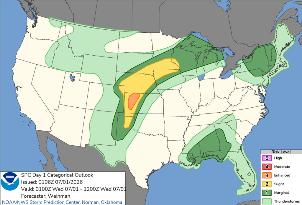
Tonight’s outlook shows exactly what a typical summer time severe set up should look like. There is the origin of the storms in western Kansas, where they may get a bit twisty, with tornadoes more likely. From Nebraska to Minnesota, one of those ripples in the air mass will act as a guide for a batch of storms with howling straight line winds – a true derecho. It’s almost midnight, and it is producing nearly 80mph winds in central Nebraska.
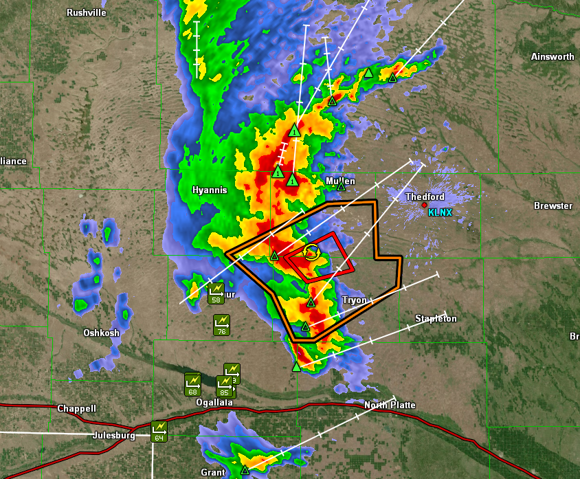
Often times, there are embedded tornadoes within squalls like this, but really, a tornado warning might just be what it takes to pay attention to a storm that will mess things up pretty well on its own.
Given the copious amounts of fuel on hot humid days, long track derechos are more likely. Even if they are derechos, lines of thunderstorms occur more frequently than the cellular storms of spring. Even in New York a line of storms is moving through upstate New York, feasting on the atmospheric moisture, rather than conflicting airmasses.
Storms like our Nebraska storm, above are also called mesoscale convective complexes. Our air mass storms in the southeast erupt when surface heating reaches a point that causes the moist air to become buoyant, rising, condensing and forming cumulonimbus clouds and eventually, thunderstorms. Those are the same mechanics for our storm in the Plains to initiate, but there is a different mechanism for its sustenance.
As I hope you have learned by now, warm or moist air rises. Typically, this is the surface warming up, but overnight, especially with the elevated thunderstorms we are seeing, cooling from the top down after nightfall is what draws those parcels of air upward. They continue to track along whatever phantom boundary, or wave or ripple exists, and they tend to roll on until that boundary tapers away.
Our Nebraska storms show no signs of dying out quite yet. Look for a loud wake up in Sioux City Iowa and Rochester, Minnesota.
May Forecaster of the Month
May is our entry into spring and summer. As much as April claims to be, things actually start happening in May. One thing that stayed the same, however, was The Weather Channel’s continued hold at the top of the Victoria-Weather Verification charts. Congrats!
| Outlet | Forecast Wins (year) |
| The Weather Channel | 4.5 |
| Clime | 2.33 |
| National Weather Service | 2.33 |
| Accuweather | 2.33 |
| WeatherNation | 2.16 |
| Victoria-Weather | 1 |
| Weatherbug | 0.33 |

Updates 6/4
11:31PM: This is getting fairly repetitive. Severe weather keeps churning in central South Dakota, and a bit of convection continues into southwest Minnesota, particularly around Montevideo and Willmar. It’s been doing this for a couple of days now! The pattern is changing for tomorrow and the weekend.
The outlook at the head of summer
June 1 is an inflection point on the meteorological calendar. It is the beginning of hurricane season, and the beginning of the meteorological summer season. Meteorological summer is marked by very warm temperatures in the south, along with dry conditions in the west and a steady diet of thunderstorms in the southeast. Also, the onus for severe weather shifts to the north. June itself is the most active severe period for the northern Plain and western Great Lakes.
How will this summer fit with the standard summer?
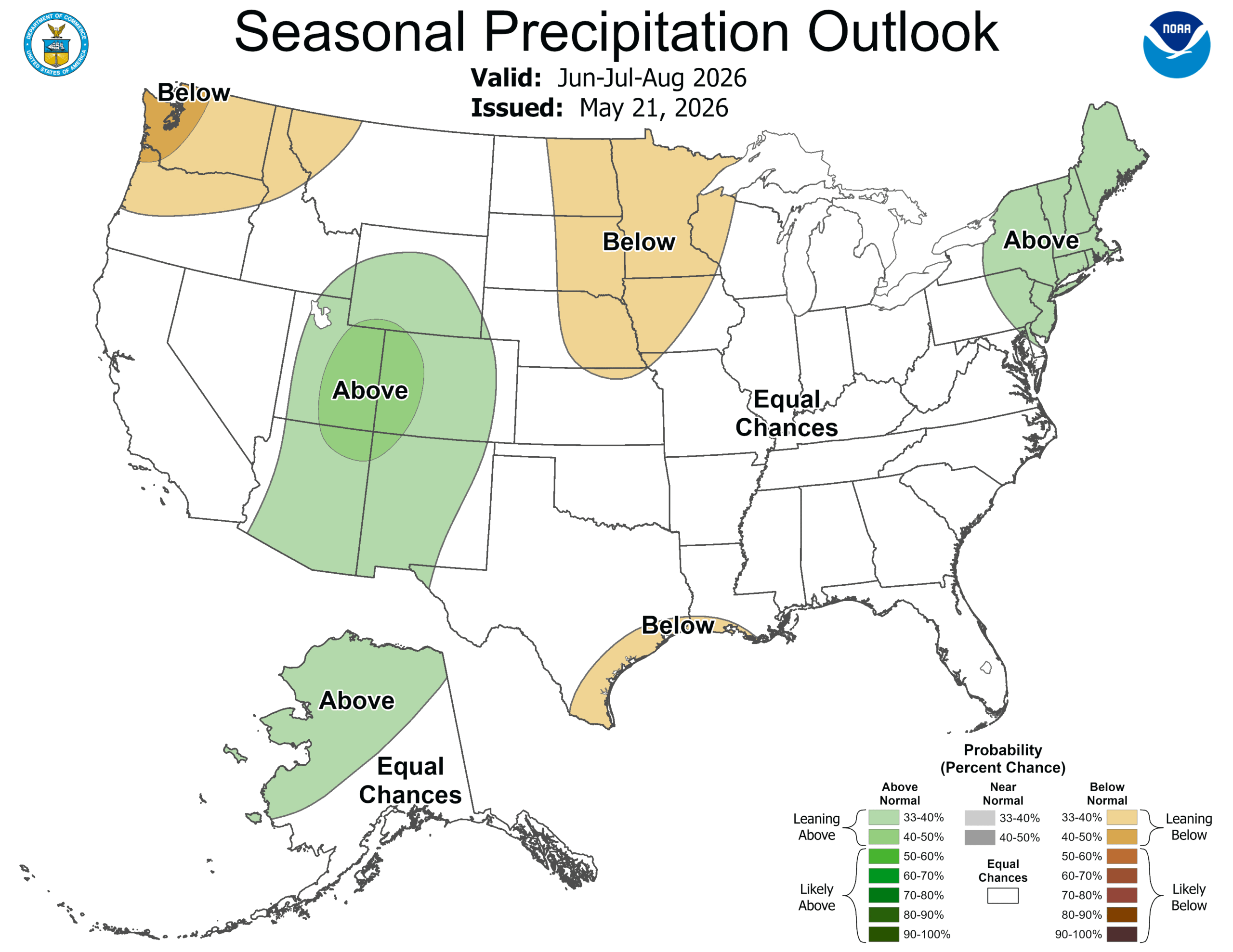
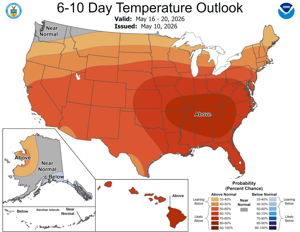
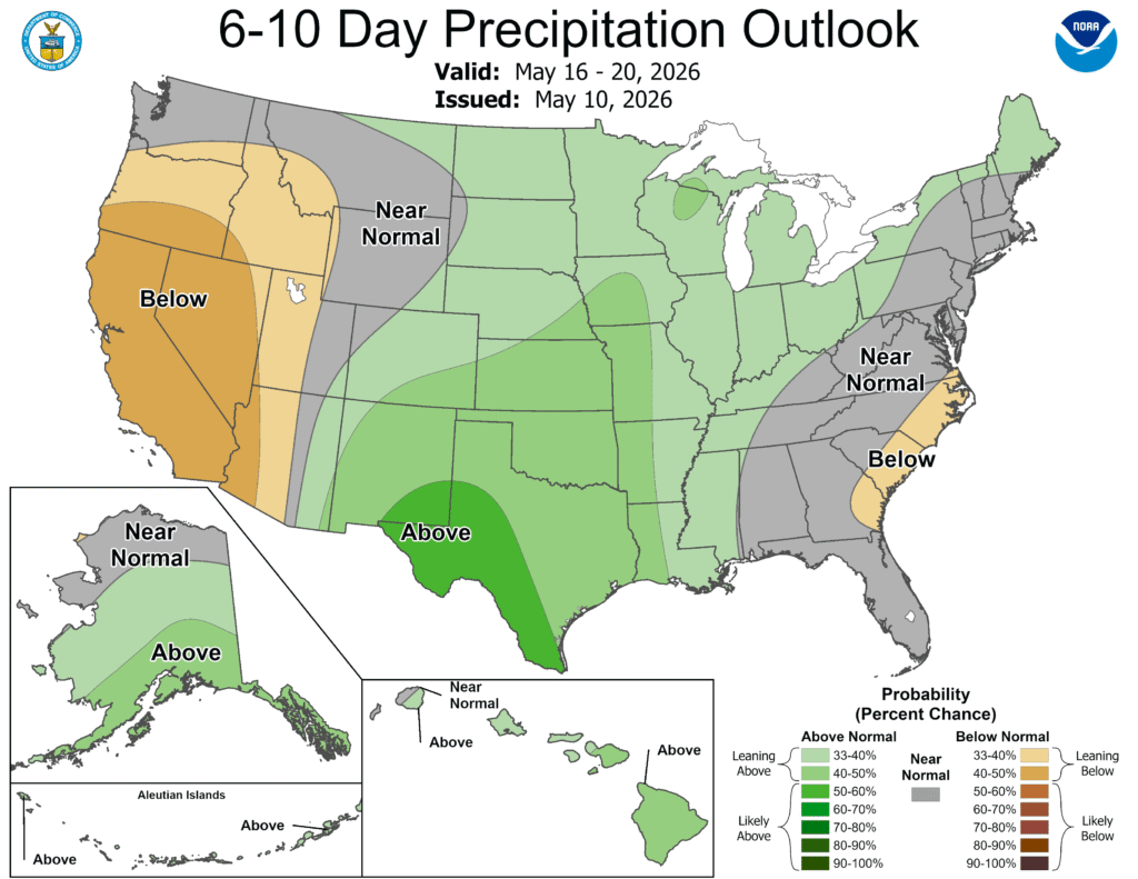
Precipitation has several areas that are expected to be outside of the normal ranges, but they are generally small, and could go either way. The only stand out is the Rockies, where it looks like the monsoon should be particularly active this summer.
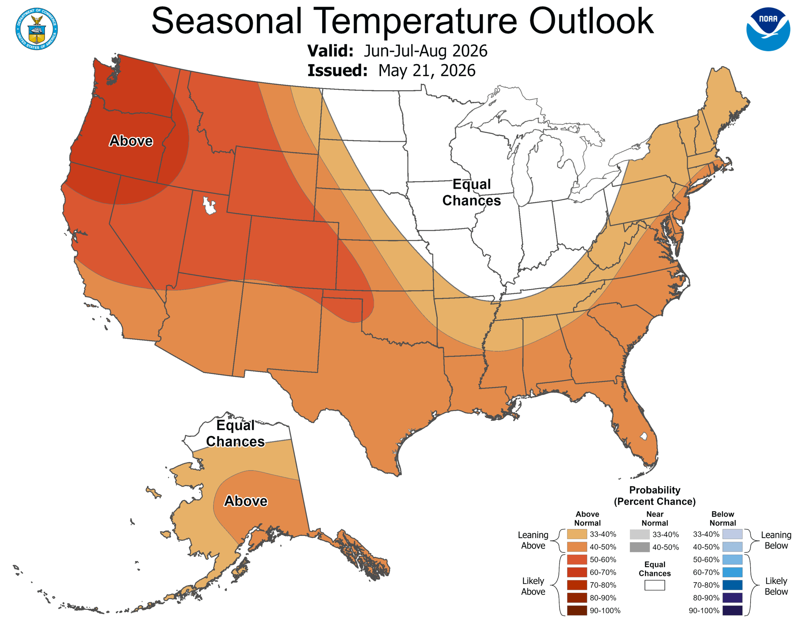
The temperatures offer a different tale. The west in particular will be warmer than normal, with the south also expected to be above normal. The hot get hotter.
Enjoy the heat, stay hydrated, and have a good summer.
Some hopeful news for the Atlantic
As has been the case recently, the trade winds over the Atlantic basin, as well as ocean temperatures are elevated. Both of these traits are consistent with active hurricane seasons, which we have certainly been privy to for the last decade or so. Also this summer, El Niño is forecast to intensify, and generally, El Niño is an inhibitor to tropical development. Which of those factors will win out?
The National Hurricane Center officially says that they believe it will be El Niño that wins the summer, and has officially forecast a below normal hurricane season because of it.
The NHC takes care to point out the importance of maintaining your hurricane vigilance even as the outlook is more favorable than it has been in a while. Part of the reason is the factors working against a quiet year hurricane season (water temperature, weak trades). Another, larger part of the suggestion for continued concern is that in the end, it doesn’t matter if the season is quiet or not if one of the few larger storm strikes your home. In 1992, there were only 7 named storms. One of those storms was Hurricane Andrew.
The outlook is promising on a holistic level, however the consistent warning when it comes to the hurricane season remains the same. It only takes one bad storm to set the impression of an entire season.
Do you know where you are?
Do you know what county you are in? You probably know what county you live in. but do you know what county you work in? Let’s say you do know that information: Do you know the name of the county just to you west? Or in any other direction?
Compounding that even further, do you travel? For work or for pleasure. If so, can you find where you are, generally, on a map? GPS is great for getting us places, but for some people, it has made map reading extremely difficult, as for most, it isn’t a muscle that often needs to be flexed.
There is one area that counties and geolocation are important. The NWS still issues watches and warnings based on counties. Radar only shows the largest locations, and even then, the scale isn’t always perfect. Or if you are traveling, say, to the Dallas area, would you realize as you are in Grapevine that you are north of Fort Worth?
This is the current radar from West Texas, simply because it is the only site with severe weather tonight.
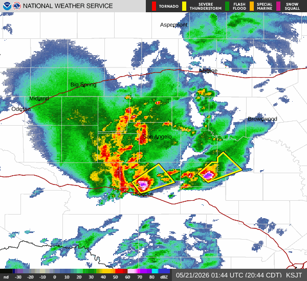
The yellow boxes represent severe thunderstorm warnings. Here is the text on one of those warnings:
...A SEVERE THUNDERSTORM WARNING REMAINS IN EFFECT UNTIL 1015 PM CDT
FOR SOUTHWESTERN MCCULLOCH...NORTHEASTERN MENARD AND NORTHWESTERN
MASON COUNTIES...

At 922 PM CDT, a severe thunderstorm was located over Us-
190 Near The Menard-
Mcculloch County Line, or near Calf Creek, moving northeast at 20
mph.

HAZARD...60 mph wind gusts and half dollar size hail.

SOURCE...Radar indicated.

IMPACT...Hail damage to vehicles is expected. Expect wind damage to
         roofs, siding, and trees.

This severe storm will be near...
  Calf Creek around 930 PM CDT.

Other locations impacted by this severe thunderstorm include The
Intersection Of Us-190 And Ranch Road 1311 and Us-
190 Near The Menard-Mcculloch County Line.

PRECAUTIONARY/PREPAREDNESS ACTIONS...

For your protection move to an interior room on the lowest floor of a
building.
You, I assume, are like me, and wouldn’t know which warning that was for, had I not just clicked on it. It wouldn’t mean much to me if I was in West Texas. In this scenario, let’s say I had heard of Calf Creek, because I was nearby in Eden. Would I know, based on the polygon that the storm was coming for me? Of if I was in Junction, would I know that it wasn’t?
One thing that meteorologists always tell you when there are forecasts for severe weather is to be prepared. Especially when you are away from home, take the time to figure out where you are on the map. If the forecast looks dicey, learn what county you are in, and even what part of the county, if you can. Victoria, for example, is in Carver County, Minnesota, and on the east side, near the border with Hennepin County. To the west, northwest and southwest are McLeod, Wright and Sibley Counties. Even when not eyeballing the radar myself, if I heard on the radio or saw an alert on TV for one of those counties, I should start to pay closer attention.
I’m a map nerd, certainly, and a lot of this comes to me naturally. That said, the weather warning apparatus necessarily makes assumptions about YOUR ability to read a map and know where you are. Take the time to hone those skills.
A new coat of paint
It’s mid-May, and we are suddenly in he severe weather doldrums, as there are a few spots of slight risk moving from the Rockies into the Lower Mississippi Valley over the next couple of days. It seems like the jump from winter weather to rote showers and thunderstorms was pretty abrupt. In fact, the story of last week was snow in Colorado and Wyoming.
This slower pattern has likely kept traffic down on our favorite weather websites, but if you were there, surely you learned quite a bit about El Nino and pollen. If you haven’t been to visit our friends, you may not have noted the refreshed look of Weatherbug
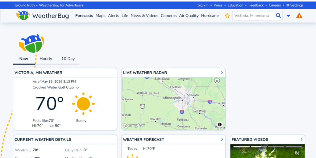
The new look is definitely informed by their background as a popular app, both on mobile, and as software starting 20 years ago. It’s clean, compartmentalized and easy to distinguish from one piece of information to another. It doesn’t feel as though an app developer tried to build a website, however, which is a very good bit of news. The bug crawling around is fun.
I know we’ve had a couple of font or layout based posts lately, but this is for two reasons. One, it’s quiet out there, but two, the importance of good communication in meteorology can’t be understated. Bad weather often needs immediate action, and that needs to be transmitted clearly. Even if not immediate, threats also need to be clearly addressed, in a manner that is obtainable by people that aren’t necessarily versed in atmospheric science.
Building trust through understanding, legibility and accuracy is important in the quiet times, as well. If we have learned anything in the last several years, it is that science is useless if it can’t be communicated.
Turning a corner
We made it through one of the chilliest stretches to start May in a while. There were readings in the Great Lakes and Upper Midwest that suggested that numbers, like morning lows around freezing, or stretches below 50, had not been seen since about 2013. This time of year, that reads more as late winter than late spring.
Finally, though, 10, going on 11 days in, the persistent eastern trough is breaking down, and warm air is flowing back north through the Eastern US. And it will persist, with warm forecasts expected for most.
It has also been a dry start to May. April Showers may be through, but May showers are appreciated, too. The jet structure is going to be lifted along the Canadian border, and will be pocked with short undercutting waves. Bundles of energy to bring some precipitation into the picture as well.
You may note that this is not a uniform color scheme. There remains some below normal precipitation in the west, but the good news is, that this typically dodgy area is actually not in a drought this year. They will withstand some dry weather .
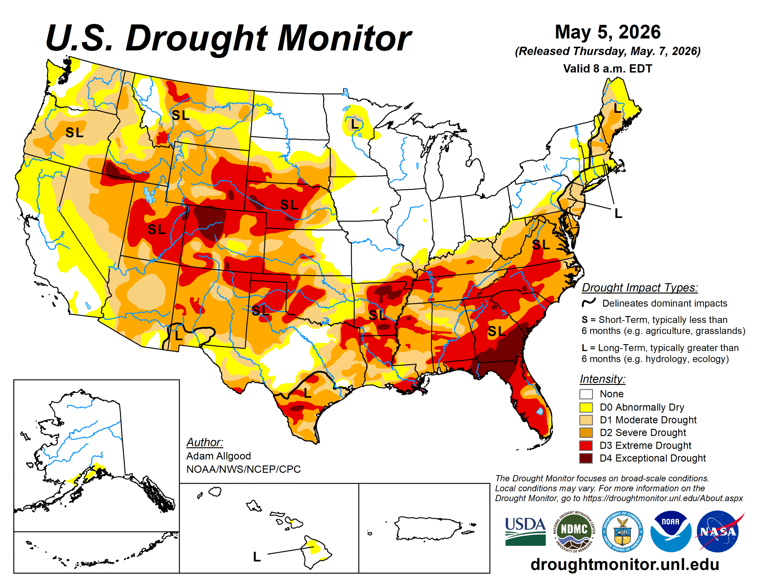
The rain is going to come in places where it is needed. The southeast and northwest remain thirsty, but the Plains are going to warm up, and be satiated for the next couple of weeks.
April Forecaster of the Month
It’s not been common lately that I’ve been able to get the forecaster of the month post up early in the following month AND it is happening on a quiet weather day. Even more rare is that this month, every outlet had a share of at least one victory… except The Weather Channel. They remain in the lead for the year, but Clime had a very good finish to the month, and it brought them to victory.
| Outlet | Forecast Wins (year) |
| The Weather Channel | 3 |
| Clime | 2.33 |
| WeatherNation | 2.16 |
| National Weather Service | 1.83 |
| Accuweather | 1.33 |
| Victoria-Weather | 1 |
| Weatherbug | 0.33 |