Youngstown, Ohio

We are headed to northeastern Ohio for our month ending forecast. It should be getting warmer right? Right?

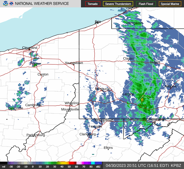
At 451PM, ET, Youngstown was reporting a temperature of 55 degrees with cloudy skies and a brisk west-northwest wind. Low pressure is parked over southern Ontario, and is bringing continuing bands of rain to the upper Ohio Valley. At present, the heaviest rain is falling over central Pennsylvania, while another band of lighter showers is evident on radar along I-77 between Canton and Cambridge.
The center of circulation isn’t going to be urged out of Ontario until after the entrance to a strong jet trough comes into being. That won’t be until Wednesday or Thursday of next week, which means reinforcing chilly flow will continue in Youngstown until then. The surface feature is going to continue occluding through the next couple of days, so clouds and rain will become lighter over time. Unfortunately, that makes it more likely for even chillier temperatures as time goes on. It will be quite breezy throughout the beginning of the week, making already cool temperatures feel even chillier.
Tomorrow – Scattered showers throughout the day, High 48, Low 38
Tuesday – Lighter showers with an isolated peek of sunshine, High 44, Low 34

TWC: Tomorrow – Showers early, becoming a steady rain later in the day.  High 47, Low 39
Tuesday – Rain and snow showers in the morning transitioning to light rain in the afternoon. High 41, Low 36

AW: Tomorrow – Cloudy, breezy and colder with a touch of rain High 45, Low 39
Tuesday- Breezy in the morning; cloudy and cold with a passing shower or two; there can be some wet snowflakes mixed in High 42, Low 35

NWS: Tomorrow – Showers, with thunderstorms also possible after 3pm High 48, Low 38
Tuesday – Rain and snow showers, becoming all rain after 9am.  High 44, Low 36

WB: Tomorrow – Showers. A slight chance of a thunderstorm in the afternoon, High 46, Low 40
Tuesday – Snow showers in the morning. Showers, High 41, Low 36

WN: Tomorrow – Cloudy with light showers and isolated thunderstorms, High 48, Low 38
Tuesday – Mostly cloudy with a light wintry mix, High 44, Low 36

CLI: Tomorrow – Rain showers, High 45, Low 37
Tuesday- Rain showers, High 42, Low 35

Frankly, I think any snow shower activity on Tuesday morning will be inconsequential. Like, a flake or two just to make people feel bad because it will be May 2nd. I don’t have the heart to include it in my forecast. Radar is fairly active, reflective of the larger storm centered to the north.

Birmingham, Alabama to Pine Bluff, Arkansas

The historic snow in the northern United States this winter is leading to some significant flooding impacts, starting in Minnesota, but probably working downriver. Our route, less than a day between Alabama and Arkansas, covering 361 miles, cross the mighty Mississippi at Helena, Arkansas, where the River is already pretty wide, and the bridge is tall. Hopefully, that means the only worries we end up having are with the ongoing weather impacts, rather than the impacts of precipitation many months ago. We’ll pass by the Mississippi Valley at a meandering 60mph pace, which at this rate, might take us a full 15 minutes to drive over the bridge.

Birmingham, Alabama

If you find yourself living in any part of the United States’ contiguous states, you are probably experiencing or will soon experience, below normal temperatures. If not, you are probably on the West Coast, and this blog is probably not the first click in your morning surf. But the below normal weather in the east is the result of a stout area of high pressure extending from Canada all the way into the American Southeast. This will keep the drive through Alabama and Mississippi pretty tranquil. An area of low pressure is going to start emerging tonight and tomorrow in the Southern Plains and start to feast on moisture banked in Texas. A weak warm front will start sneaking north in Arkansas which could bring some late puffy cloudy to the Pine Bluff area. They aren’t likely to bring rain before our drive is over, but expect a wet middle to the week in Pine Bluff.

Pine Bluff, Arkansas

Pine Bluff, Arkansas

It’s time for a forecast in Arkansas. Arkansas finds itself between the Dixie Alley and the more traditional Tornado Alley in the high Plains, and sees it’s fair share of twisters. This is the time of year for them, but will that be the case this week?

At 953PM, CT, Pine Bluff was reporting a temperature of 61 degrees with overcast skies. Surface low pressure over the Great Lakes is dragging a cold front through northern Louisiana. A chilly north wind is blowing throughout Arkansas, and while much of the state is expected to cool significantly overnight, it will likely be slow to do so in Pine Bluff. A jet running parallel to the base of the trough is suspending the cold front, leaving clouds across southern Arkansas, and preventing radiational cooling. Amid the clouds are a few light rain showers streaming across Arkansas, but dropping dew points in the area are preventing all the rain seen on radar from reaching the ground.
In the entrance area of the southern jet, there is going to be some disorganized shower and thunderstorm development. Onshore flow in the region will bring about enough moisture and potential energy for some rain and embedded thunderstorms across east Texas, with some activity spilling eastward. The best threat for rain will be on Sunday, wrapping up late in the evening. Monday should mostly be dry, but unseasonably cool. More clouds are expected to move in late on Monday.
Tomorrow – Scattered showers ending in the late evening, High 55, Low 45
Monday – Mostly sunny, with clouds returning late, High 65, Low 40

TWC: Tomorrow – Cloudy skies (early rain). High 59, Low 46
Monday – Except for a few afternoon clouds, mainly sunny. High 69, Low 41

AW: Tomorrow – Cloudy and cooler High 59, Low 48
Monday – Mostly cloudy High 69, Low 43

NWS: Tomorrow – A 20 percent chance of rain before 9am. Mostly cloudy, High 58, Low 45
Monday – Mostly sunny, High 66, Low 42

WB: Tomorrow – Mostly cloudy. A chance of rain in the morning. High 68, Low 47
Monday – Mostly sunny, High 68, Low 43

WN: Tomorrow – Mostly cloudy with isolated showers, High 58, Low 45
Monday – Partly cloudy, High 66, Low 42

CLI: Tomorrow – Light rain showers, High 61, Low 45
Monday – Partly cloudy, High 66, Low 43

Model guidance is falling short of the blend and consensus temperature forecasts. We’ll see who is better, man or machine. Rain has moved into Pine Bluff since I started writing this forecast.

The thrill of an early spring

Let’s all look back fondly at the middle of April. Warm temperatures and generally sunny skies dominated a lot of the middle of the country. That started slowly eroding, and now with the advance of a strong cold front tonight in the Mississippi Valley, is disintegrating quickly. But last week, think Wednesday and Thursday of last week in Canton was brilliant. Highs in the upper 70s to near 80 with nary a cloud in the sky. Clime and The Weather Channel each tied for the top forecast, which weren’t as good as expected, because the weather was even better than anyone ever imagined.
Actuals: Wednesday. April 12th, High 77, Grade 55
Thursday, April 13th, High 80, Low 54

Grade: B-C

Canton, Ohio

Canton is the home of the football hall of fame. It isn’t football season, but I don’t know a lot else about Canton.

At 1051PM, ET, Canton was reporting a temperature of 60 degrees with fair skies. High pressure is smothering the eastern two thirds of the country, and a nice dry, warm launch to spring has seized Ohio and the Great Lakes at large.
Satellite shows the greatest concentration of cloud cover spreading into the Appalachians of Pennsylvania and New York, thanks to the exit region of a jet sliding into New England. There are some streaming clouds over Ohio that may help prevent temperatures from plummeting overnight. Non tropical low pressure rising out of the Gulf will bring another smattering of clouds later in the week.
Tomorrow – Mostly sunny, High 76, Low 50
Thursday – Sunny, High 77, Low 52

TWC: Tomorrow – Abundant sunshine. High 77, Low 53
Thursday – Mainly sunny. Mainly sunny, High 79, Low 51

AW: Tomorrow – Partly sunny and very warm; breezy in the afternoon; dry and breezy conditions can lead to an elevated fire risk High 78, Low 53
Thursday – Mostly sunny and very warm High 78, Low 52

NWS: Tomorrow – Sunny High 78, Low 52
Thursday – Sunny High 78, Low 51

WB: Tomorrow – Partly cloudy, High 74, Low 53
Thursday – Sunny, High 76, Low 52

WN: Tomorrow – Mostly sunny, High 75, Low 52
Thursday – Sunny, High 80, Low 51

CLI: Tomorrow – Sunny, High 75, Low 54
Thursday – Sunny, High 79, Low 52

It’s going to be a battle of temperatures in what should be a pretty good forecast. Satellite is fairly quiet.

March Forecaster of the Month

March was a heck of a month. May has a long history as one of the most tornado rich months of the year, but this month served as a reminder that tornado season starts as early as March. Deadly Twisters from Mississippi in the south to Illinois in the north were the major headline, but relentless blizzards and continued cold and flooding in the northern and western US were also factors in a wild month. Victoria-Weather tamed that beast, though, and we claimed the top forecasting month for March.

OutletForecast Wins (year)
Victoria-Weather3
Clime1.5
National Weather Service1.5
Weatherbug1
Accuweather
The Weather Channel
WeatherNation

Calm ahead of the storm

It’s been an active start to the tornado season, with the most deadly storm arriving in Mississippi at the end of March. Nearby Dothan was the target of our forecast on March 22nd, and even then, we were watching storms developing in the southern Plains and speculating on what they mean for Dothan. Fortunately for our forecast outlets, they merely brought some warmer air and morning fog, at least during the forecast period. The swell of Gulf moisture was fairly well anticipated, and was among the factors in this well anticipated severe season. For Dothan, the top forecaster was Weatherbug, an outlet in sore need of a pick-me-up. Good on them.
Actuals: March 23rd, High 79, Low 56
March 24th, High 81, Low 59

Grade: A-C