If you like winter weather, the Great Lakes and New England are great places to be. Snow comes in heavy in that part of the world, and is usually the wet, dense stuff, perfect for snowmen and snowballs, and not the wispy inch or two you get in the Plains that aren’t really good for anything. What is worse than that, though, is when it rains. That’s all they got in Lima on the 11th, in the distant past when we issued our forecast for the northwestern Ohioan town. What a tease! Victoria-Weather saw it coming, though, and collected the top forecast in town, for our first win in 2022. Actuals: February 10th, High 37, Low 28 February 11th – .12″ of rain, High 43, Low 28
The Chicago area covers a lot of territory, and even covers some smaller microclimates, wrapping around Lake Michigan as it does. The site we use to verify defaults to Chicago-Midway, so we will as well. Just know, what happens at Midway doesn’t always happen at O’Hare.
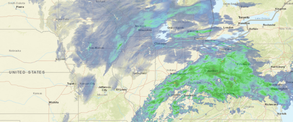
At 829PM, CT, Chicago Midway was reporting a snow with fog and low clouds. A vigorous southwest to northeast trough runs from Texas to the Great Lakes, and a perturbation in the Upper Midwest has led to a surface feature that is presently organizing over western Kentucky, extending an inverted trough through northern Illinois and bringing the snow that is being seen in the region. The low will continue to organize and jet off to the northeast, pressed on by the swift flow aloft. After the surface system and abetting upper level perturbation aloft shift out of the region overnight tonight, expect clearing to take hold. The jet to the south will remain in place, keeping any hope for warmth at bay through the weekend, but the swift flow aloft will lead to some mid to high level clouds, which will keep it a couple of degrees warmer overnight. After flurries end early tomorrow morning, Chicago will be brisk but dry through Saturday. Tomorrow – Early AM Flurries, then a bit brisk, mostly cloudy, High 30, Low 21 Saturday – Partly cloudy, breezy, High 36, Low 20
TWC: Tomorrow – Mostly cloudy skies. A few flurries or snow showers possible. High 29, Low 24 Saturday – Sunny skies High 36, Low 18
AW: Tomorrow – A couple of flurries early in the morning; otherwise, mostly cloudy and cold; watch for icy spots in the morning High 29, Low 23 Saturday – Mostly sunny; breezy in the afternoon High 36, Low 19
NWS: Tomorrow – A chance of snow between 8am and 2pm, then a chance of flurries after 2pm. High 29, Low 23 Saturday – Sunny, High 33, Low 18
WB: Tomorrow – Mostly cloudy and a chance of flurries and a slight chance of light snow in the morning, High 27, Low 22 Saturday – Sunny, High 32, Low 18
WB: Tomorrow – Mostly cloudy with scattered snow showers, High 28, Low 25 Saturday – Sunny, High 34, Low 20
FIO: Tomorrow – Foggy overnight and in the morning. High 29, Low 20 Saturday – Clear throughout the day. High 34, Low 16
A little snowy in Chicago, but we are at the end of it. Only The Weather Service specifically directs to Midway in their forecast offerings, so we will see if that has any bearing on how things turn out.
We are halfway through February, and the schedule has still not permitted time to reward the forecasters of the month in December and January, let alone the forecaster of the year for 2021. Naturally, we have an opening just before a fairly significant weather system sets to blast the south central US. I’ve been giving a lot of updates to friends on that, so it’s time to take a step back to review where we have come from.
First, I will start with the December champion, because I’m sure that will be top of mind for everyone, and I like to give a shout out when an unusual champion makes a stride. Forecast.io won the month of December. Good for them!
With that in mind, we can also award the title for Forecaster of the Year. It was close for a lot of the year, and our winner was even in second place until about August, but then they surged and won going away. The Weather Channel was the strongest forecaster in 2021, and it’s hard to dispute this as a fluke. Way to go, TWC, you were dominant. Kudos to Weatherbug, who had the highest highs, earning the most individual forecast victories, but sloughing off when they weren’t at the top of the heap. It’s about consistency, not just the wins.
Outlet
Forecast Wins (year)
Weatherbug
16.99
Victoria-Weather
12
The Weather Channel
11.66
Forecast.io
10.66
Accuweather
8.83
National Weather Service
6.16
WeatherNation
1.66
And now, finally, we can conclude with the champion for the month of January in 2022. We were awfully light on the forecasting to start the year, but we can say, with confidence, that The Weather Channel didn’t let off the gas pedal, just because they started the new year. Congratulations for all the good news, Atlanta!
The beginning of this month has brought a relentless cavalcade of systems moving along the east coast, keeping it snowy in New England and the Mid Atlantic and cold in the middle of the country. Where the two meet and merge with the south, AKA the southern Appalachians, it has been icy at times. On Monday in Hickory, there was .16″ of freezing rain, which is enough to cause a fair share of issues for locals. The temperatures climbed into the 50s on Tuesday though, which helped to clear things up. We put together a forecast last Sunday, and it was won decisively by Accuweather. Actuals: Monday – .16″ of rain, High 39, Low 29 Tuesday – High 54, Low 30
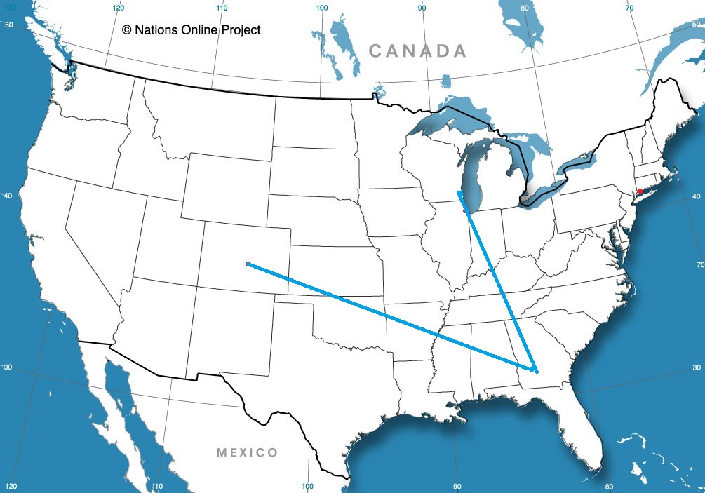
It’s the depths of winter for a lot of us, but this is close to the time that the southern US starts to wake up for Spring. We’ll traverse the heart of the USA for our 3 day trip from Texas to Ohio. It’s a 1,488 mile journey, at a pace of 67mph, which will lend itself to a 537 mile drive on the first two days of our trek. We’ll finish the drive on a shorter day in order to enjoy all that Lima has to offer.
DAY ONE (Saturday)
Laredo is the county seat of Webb County, Texas, United States, on the north bank of the Rio Grande in South Texas, across from Nuevo Laredo, Tamaulipas, Mexico.
Another surge if cold air is headed for Texas this weekend. An area of low pressure is going to bring heavy snow to the Great Lakes, but for our drive tomorrow, the trailing cold front will arrive in Texas early in the day. Rain will squeeze out in front of the boundary, but that should hold off until we get to Austin. After that, wind and light rain will be a concern through the early afternoon. Some wet snow could mix in before the rain ends while we approach Dalls. Clearer conditions will try to press in by the end of the day, but expect it to be chilly, and for some slick, icy spots on the roads. We’ll end the day in Winfield, Texas
DAY TWO (Sunday) So much for the hints of spring I was hoping for. It’s still going to be cold for our route through the south central US. The deepest part of the thermal trough will align, essentially, with our route on Sunday, but fortunately, the precipitation will be confined well south of our route, closer to the Gulf Coast. The day will end in Bellevue, Tennessee, a southwest suburb of Nasville.
DAY THREE (Monday) Another clipper is going to scoot through the Great Lakes to start the week, another in a series of similar features. This one will ride a bit further north of the tracks that have been in place lately, and won’t likely bring snow to Lima. Fortunately, Lima is in the one spot of northern Ohio that isn’t susceptible to lake effect snow, so expect some clouds, but a pretty generic winter day in Lima when we arrive.
Sure I’m up late, but the Olympics are in Beijing, and on TV at all the wrong times. Speaking of the Olympics, these are the winter games, and Lima will get pretty wintry as we wrap up the week.
At 1253AM, ET, Lima was reporting a temperature of 37 degrees with mostly cloudy skies. The southern end of a Canadian trough is moving through the Lima area tonight, but will be out of the hair of Lima residents entirely by the time the sun rises. It will shine brightly as clouds associated with the area of low pressure will shift northeast. The next feature is a Clipper already forming in the Canadian High Plains. The heart of the feature will move through Wisconsin and Michigan on Friday, but the tailing cold front will sweep through northern Ohio. Snow is likely to arrive on Friday, heavily at times around noon, but mixed a bit with rain initially. It will then get colder with a few flurries possible through the afternoon. Tomorrow – Clearing, but still partly cloudy, High 37, Low 30 Friday -Rain mixing with snow, around midday, flurries late, High 42, Low 28
TWC: Tomorrow – Cloudy skies, early snow, High 36, Low 31 Friday – Cloudy with periods of light rain, High 41, Low 27
AW: Tomorrow – A couple of morning flurries; otherwise, cloudy and colder High 38, Low 31 Friday – Breezy and milder; sun and areas of high clouds in the morning, then a mix of snow and rain in the afternoon High 40, Low 26
NWS: Tomorrow – A 20 percent chance of snow showers. Cloudy, High 33, Low 25 Friday – Snow before 8am, then rain and snow between 8am and 11am, then rain after 11am High 41, Low 24
WB: Tomorrow – Cloudy with a 20 percent chance of snow showers, High 36, Low 28 Friday – Windy cloudy, rain. Possibly mixed with snow in the morning. Then chance of rain in the afternoon. High 40, Low 28
WN: Tomorrow – Mostly cloudy with slight chance of light snow showers, High 33, Low 24 Friday- Cloudy with light wintry mix, High 40, Low 24
FIO: Tomorrow – Overcast throughout the day. High 34, Low 23 Friday – Light rain starting in the morning. High 40, Low 23
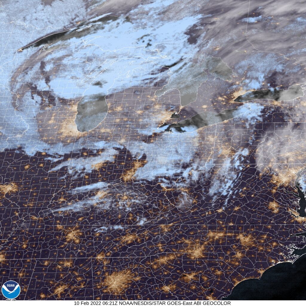
This verification is going to be very interesting. A mixed assortment of precipitation forecasts, as well as questions about the temperature trajectory, especially for Thursday. I’m intrigued. Here is the satellite, with some clouds nosing in from Michigan. This isn’t much, and a more notable system is on it’s way.
The Texas Panhandle was a chilly place to be at the end of January and beginning of February. Well, it was cold in Amarillo relative to most of the forecasts available, but Tuesday was actually quite chilly. Monday was in the mid-60s, but was still a few degrees shy of the forecast. Accuweather was on the low end of the forecast range, and had a very good total, winning the day. Monday – High 66, Low 29 Tuesday – High 46, Low 32
Tonight’s forecast comes to us from a part of the country that just got through a wintry slap in the face. Are things soon to be on the up and up?
At 953PM, ET, Hickory was reporting mostly cloudy skies with a temperature of 32 degrees. a weak area of low pressure was working its way inland from the South Carolina coast. While this emerging feature is bringing the moisture, the already in place cool temperatures will ensure that the precipitation will be frozen, either as light snow, or perhaps a bit of sleet. Hickory should be at the western most extent of this threatening weather, but nevertheless, there is a winter weather advisory in place for the morning. A southwesterly jet streak at the leading edge of a sharp trough is going to strengthen and draw northeastward. The precipitation tomorrow morning, if there is any, will be shortlived, but the cold air behind the feature will persist through the day. Weak flow will return at the surface as the jet structure becomes muddled aloft. It won’t necessarily be warm in Hickory on Tuesday, but surely, it won’t be as cold. Tomorrow – Morning sleet, with a little bit of rain to finish, otherwise mostly cloudy in the afternoon High 44, Low 28 Tuesday – Partly cloudy, High 53, Low 26
TWC: Tomorrow – Freezing drizzle in the morning, then mostly cloudy late, High 45, Low 27 Tuesday – Some clouds in the morning will give way to mainly sunny skies for the afternoon. High 54, Low 29
AW: Tomorrow – Mostly cloudy and chilly with spotty drizzle High 42, Low 29 Tuesday – Milder with times of clouds and sun High 52, Low 30
NWS: Tomorrow – A chance of freezing rain before 8am, then a chance of freezing rain and sleet between 8am and 10am, then a chance of rain after 10am. Mostly cloudy High 43, Low 29 Tuesday – Sunny, High 51, Low 27
WB: Tomorrow – A chance of freezing rain in the morning. Mostly cloudy with a chance of rain. High 44, Low 30 Tuesday – Sunny, High 53, Low 30
WN: Tomorrow – Mostly cloudy with chance of a light wintry mix, High 43, Low 28 Tuesday – Mostly sunny, High 51, Low 27
FIO: Tomorrow – Possible light rain in the morning and afternoon. High 44, Low 30 Tuesday – Clear throughout the day. High 52, Low 28
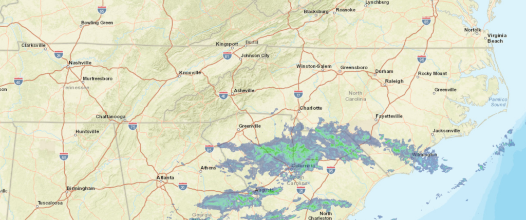
The Weather Service and Forecast.io agree with me: The clouds are going to slow down the cooling tonight, and it will actually be colder on Tuesday morning. Other than that, only Accuweather’s precipitation forecast really stands out. Here is the radar tonight, with precipitation falling as rain in South Carolina (where it is being noted)