Temperatures in Spokane were downright delightful last week. After a long hot summer, they deserved the mid – 70s that they saw, though admittedly, the bit of drizzle early Friday morning was a bit of a tease, given the wildfires and drought encompassing the western US this summer. The Weather Channel collected the top forecast of the day, narrowly, and would have had something special if only they had accounted for the drizzle. Actuals: Thursday – High 77, Low 53 Friday – Trace of rain, High 75, Low 55
Grade: B-C
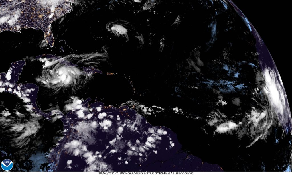
Victoria-Weather expresses our grief and wishes for a rapid recovery to southeastern Louisiana and the residents that have been so heavily impacted by Hurricane Ida. We encourage readers to donate to hurricane relief via the Red Cross.
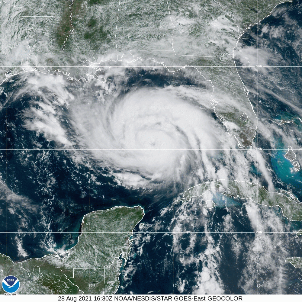
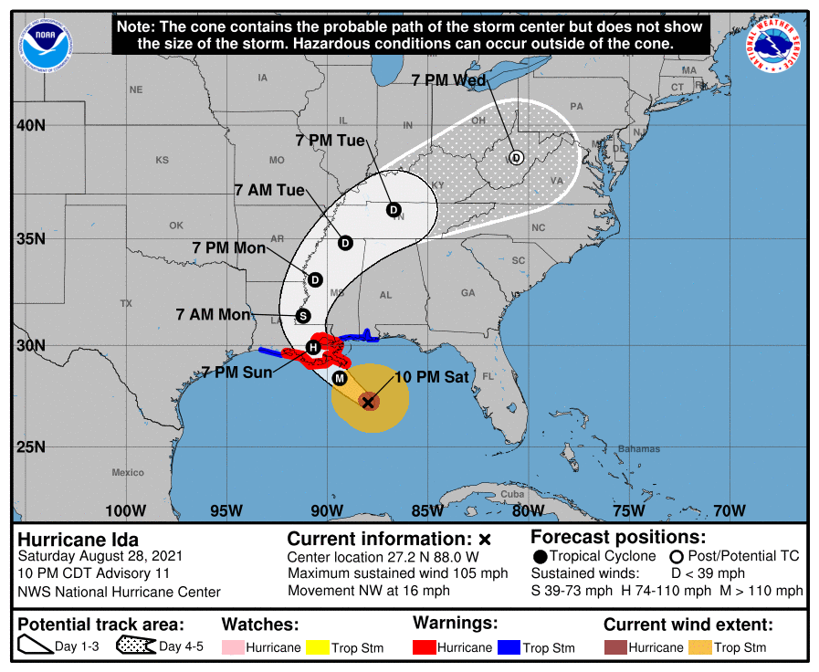
Hurricane Ida sits off the coast of Louisiana, and will descend upon the Bayou State tomorrow. Strong winds are already starting to pick up from Mobile to the Mississippi Delta. At this hour, Ida is a Category 2, but she is slowing down her momentum and is anticipated to strengthen rapidly. The NHC suggests that Ida will become a major hurricane, likely a Category 4 before she comes ashore.
Ida’s swift momentum before this point brings good news, in the fact the storm surge will not be as terrible as it could be, given it’s status as a major hurricane. The rapid development before it makes landfall also limits the fetch and the subsequent coastal flooding. Additionally, if Ida closely follows the forecast track, she will landfall south of Houma, a bayou laden, sparsely populated (relatively) stretch of coastline. This is the good news.
The bad news is that a Category 4 storm is still strong. It will pass near enough to New Orleans to cause significant problems. There will also be a disruption to the platforms in the Gulf, and a hike to gas prices nationally as a result. Also, with Ida’s recent slowdown, heavy rain and flash flooding will become a concern. The gravest concern, and what makes Ida more dangerous than most, is that because she is expected to develop so quickly, mass evacuations were not issued. There are simply far more people in the line of fire than there would be typically when a major hurricane is bearing down.
Another bit of good fortune is that Ida is a compact storm, and as a result, will not impact even the entire state of Louisiana. Where she will impact though, will struggle to recuperate. Ida will landfall tomorrow evening, and will finally pull away from Louisiana on Monday evening.
The weekend is fast approaching, and I think that is one thing everyone can come to appreciate. How much, exactly, will Hickorians (?) appreciate the weather this weekend?
At 1053AM, ET, Hickory was reporting a temperature of 80 degrees. Clear skies were reported across the region, however some fog and low clouds appeared in the valleys closer to Asheville. A band of mid and high clouds was seen along and southeast of a line from Greenville to Fayetteville. High pressure was otherwise seizing the day in the Mid Atlantic. There is some weak baroclinicity, which will organize a bit over the weekend outside the mouth of Chesapeake Bay, but the story everyone will be watching is the rapid intensification of Tropical Storm Ida, which will be a major hurricane in the Gulf of Mexico by Saturday evening, likely to make landfall southeast of Lafayette late on Sunday, after lingering just off shore for the weekend, with potentially disastrous side effects. Hor Hickory, this will function to remove moisture or conflicting flow into the region, and will lead to sun and clear skies, which probably means some toasty conditions. Tomorrow – Sunny and warm with haze and fog early, High 94, Low 70 Sunday – Sunny and hot with morning clouds and fog, High 95, Low 71
TWC: Tomorrow – A mainly sunny sky. High 92, Low 69 Sunday – Sunny skies. High 93, Low 68
AW: Tomorrow – Mostly sunny and very warm High 93, Low 68, Sunday – Mostly sunny and warm with the temperature approaching the record of 94 set in 2007 High 93, Low 69
NWS: Tomorrow – Patchy fog before 8am. Otherwise, sunny, High 93, Low 69 Sunday – Sunny, High 94, Low 68
WB: Tomorrow – Patchy fog in the morning, Sunny. High 91, Low 70 Sunday – Sunny, High 92, Low 68
WN: Tomorrow = Mostly sunny, High 93, Low 69 Sunday – Mostly sunny, High 94, Low 68
FIO: Tomorrow – Humid throughout the day. High 89, Low 67 Sunday – Humid throughout the day. High 89, Low 65
Hurricane Ida will definitely make headlines this weekend, but her presence will ensure the Carolinas have sunny skies this weekend. Satellite now shows some general clouds in the southeastern part of the state, and lingering fog in the mountains.
Summer can be brutally hot through the center of the country. 90s with humidity aren’t out of the question in Springfield in August, so anything less than that is a treat. Consider last weekend to be a treat, then. On the 14th, there was supposed to be a bit of rain, but it was unseen in Springfield, leaving only the completely tolerable temperatures that maxd out in the 80s. The lows were a little warm, especially the 71 on the 14th, but much more accommodating on the 15th. Victoria-Weather and The Weather Channel were optimistic enough to put together these relatively pleasant days in their forecast, and shared the forecast victory. Actuals: August 14th, High 86, Low 71 August 15th, High 86, Low 64
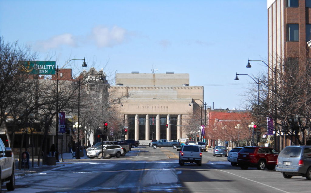
When people think of Washington, most, I believe, think about Seattle, Tacoma and the Puget Sound area. Rainy and glum for a lot of the year. That is now what you should expect in eastern Washington, though. Let’s take a look at the biggest town in Washington east of the Cascades.
At 1053AM, PT, Spokane was reporting a temperature of 67 with mostly cloudy skies. An unusual feature has set up in the northwest: a cool area of surface high pressure. A trough aloft was opening the door for cooler air to fill in, but in the short term, surface reflection, aside from the temperatures, was not anticipated. Flow was stout enough from the west that fires in Oregon were not impacting air quality as much as they have recently. The upper level trough is low amplitude and broad, but a lobe of vorticity will sneak down from British Columbia late on Friday. This will lead to some breezier conditions and some clouds, but will also help to usher the trough out of town. Importantly, this will also help temperatures start on the rise again for the weekend, but through the forecast period, it will be pleasant. Tomorrow – Partly cloudy, High 76, Low 57 Friday – Partly to mostly cloudy with some breeze, High 73, Low 56
TWC: Tomorrow – Partly cloudy skies in the morning will give way to cloudy skies during the afternoon High 77, Low 54 Friday – Partly cloudy. High 74, Low 55
AW: Tomorrow – Comfortable with partial sunshine (late rain) High 76, Low 55 Friday – Pleasant with sunshine and some clouds (Early rain) High 72, Low 55
There are presently three named features in the north Atlantic and North America. Fred is continuing his slow spin into oblivion over the eastern US, while Tropical Storm Grace is moving through the Caribbean and Tropical Storm Henri is spiraling out by Bermuda. You can see them all on satllite.
Well, at least you can see the tail end of Fred. He is a spiraling storm presently threatening rain and tornadoes to the central Appalachians. The rotational energy will dissipate through tomorrow, but rain will continue in the mid-Atlantic tomorrow.
Off shore, Henri is presently the stronger storm, and likely will be the case until Grace reaches the open Gulf again. Henri will disrupt travel to and from Bermuda, but is not going to affect the island directly. Grace, the weaker seafaring storm, has never really been able to muster herself to become a hurricane, and looking at the wind history, hasn’t been a significant storm.
Of course, there are times when the numbers don’t tell all the story. Even when considering Fred, Henri is the strongest of these three storms (though Grace may eventually overtake him), and Fred has been dropping tornadoes in the western Carolinas all day, but it is indeed Grace that has been the most problematic.
Grace passed through Haiti at a time when the country was struggling with the aftermath of a strong earthquake that left thousands dead. Grace brought flooding rains to the country as relief efforts were underway. There is a point at which the death toll from the earthquake and Grace are inextricably linked, but at this point, no loss of life has been assigned to the storm. Whatever the statistics bear out, Grace, in all her disorganization came at the worst time to the worst place, something that will never describe Henri, even if he is the bigger storm.
We are a nation divided. Any watch of the news will tell you that, but also, we are divided climatologically right now. Its hot and dry west of the Mississippi, and it’s been tolerable but west to the East. Such was the case in Bloomington, Indiana at the beginning of last week, when temperatures were allowed to remain in the 80s, and on Monday, the ground soaked up half an inch of rain. Surely, half the country would appreciate the wealth being shared. Victoria-Weather stepped up and earned the top forecast. Actuals: Sunday – High 87, Low 67 Monday – .53″ of rain, High 82, Low 69
I’m always interested in the more diagonal routes. They take us over terrain we don’t always get to see. Such is the case with this ride, which will take about 2 1/2 days through the Rockies and High Plains. We’ll cover 1457 miles at a pace of nearly 70mph. The drive will conclude at the end of the first two days after 555 miles of sincerely wide open terrain.
DAY ONE (Tuesday)
Great Falls Montana – By Montanabw – Own work, CC BY-SA 3.0, https://commons.wikimedia.org/w/index.php?curid=25249931
It’s extremely dry across so much of the country, and it has led to wildfires blanketing the country in smoke. Our route is affected by the smoke, even, with parts of US 212 closed because of the fires, requiring a trip through Wyoming on I-90. We’ll make it to Whitewood, South Dakota, in the Black Hills before the drive is over. A lobe of low pressure will swing into the Northern Rockies, and will bring rain to western Montana. We’ll stay dry in Whitewood, and throughout our drive.
DAY TWO (Wednesday) Low pressure is going to deepen quickly in the High Plains east of the Rocky Mountains, but through the day in South Dakota and south into Iowa, the feature will only function to drive hot humid air north. Brisk, hot winds are expected, but the low isn’t going to move anywhere, so precipitation is not anticipated.
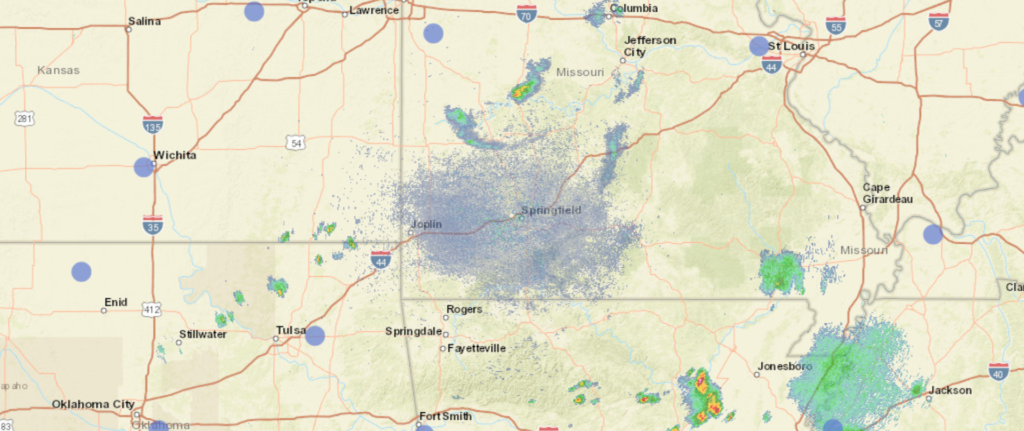
DAY THREE (Thursday) The Gulf will be opened by the aggressive southerly flow, and showers with isolated thunderstorms are expected to start bubbling northward. Showers with a few rumbles of thunder are possible from Kansas City south to Springfield
Springfield is just north of the Ozarks in southwest Missouri. It’s a surprisingly well populated region, with Springfield the largest town to speak of.
At 1052AM, CT, Springfield was reporting a temperature of 74 degrees with clear skies. Dew points were in the mid 60s, which definitely led to some discomfort, and it will only get warmer through the day. There appeared to be a dry line south of town, as dew points and temperatures were significantly higher even in Oklahoma, not so far away. The boundary has led to a few scattered showers popping up in the region, but the heaviest rain was north of the aforementioned boundary. The boundary responsible is eventually tied to a shortwave in the Great Lakes. High pressure is building over the north central US and will press south, limiting the flow of moisture into the Plains. Because the boundary is so removed from the parent low, which itself is only a weak shortwave, it won’t feel obliged to move any faster than the ridge sinks south. Clearing will finally come by Sunday with the Gulf effectively staunched. High pressure generally means cooler temperatures, as it will in Missouri for the middle of August. Well, relatively cool. Tomorrow – Tomorrow – Partly cloudy with scattered showers, High 85, Low 69 Sunday – Mostly sunny, High 85, Low 66
TWC: Tomorrow – Scattered thunderstorms in the morning, then cloudy skies late. High 84, Low 69 Sunday – A few passing clouds, otherwise generally sunny High 84, Low 64
AW: Tomorrow – A thunderstorm in spots in the morning; otherwise, humid with times of clouds and sun Hih 81, Low 69 Sunday – Nice with times of clouds and sun High 82, Low 65
NWS: Tomorrow -A 50 percent chance of showers and thunderstorms. Partly sunny, High 84, Low 69 Sunday – Mostly sunny, High 83, Low 65
WB: Tomorrow – Partly sunny with a 40 percent chance of showers and thunderstorms, High 81, Low 71 Sunday – Partly cloudy, slight chance of showers in the morning then slight cance of showers and thunderstorms in the afternoon High 82, Low 65
WN: Tomorrow – Partly cloudy with chance of storms, High 84, Low 69 Sunday – Partly cloudy with isolated showers, High 83, Low 65
FIO: Tomorrow – Mostly cloudy throughout the day. High 83, Low 67 Sunday – Clear throughout the day. High 82, Low 59
Radar with a few isolated showers rolling through the region Storms should remain non-severe, so that’s nice.
It was a slow start to the summer in the southern US, with temperatures that were actually fairly comfortable. It couldn’t last, of course. It never does, and in Florence and the rest of northern Alabama, it was a taste of what residents usually come to expect in August. Temperatures were in the 90s by Monday afternoon, with dew points well into the 70s. It was a steam room just being outside on Sunday and Monday in Florence. Granted, it’s a couple degrees warmer than normal, but it’s also not as far out of the ordinary as the cooler start was. Weatherbug had the top forecast for the period. Actuals: Sunday – High 89, Low 70 Monday – High 94, Low 74