We’re entering some of the snowiest months of the year, but if trends continue, we won’t really be worrying about that.
Springfield, Massachusetts
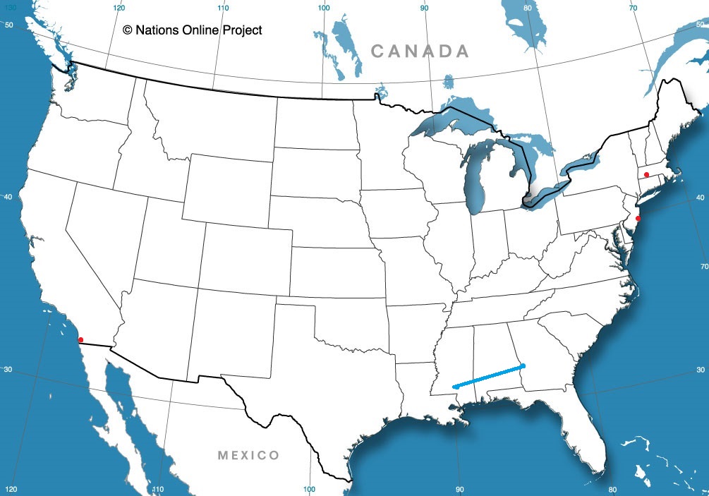
Road Trip from Columbus, Georgia to Hattiesburg, Mississippi
Ocean City, New Jersey
from Victoria-Weather

We’re entering some of the snowiest months of the year, but if trends continue, we won’t really be worrying about that.
Springfield, Massachusetts
Road Trip from Columbus, Georgia to Hattiesburg, Mississippi
Ocean City, New Jersey
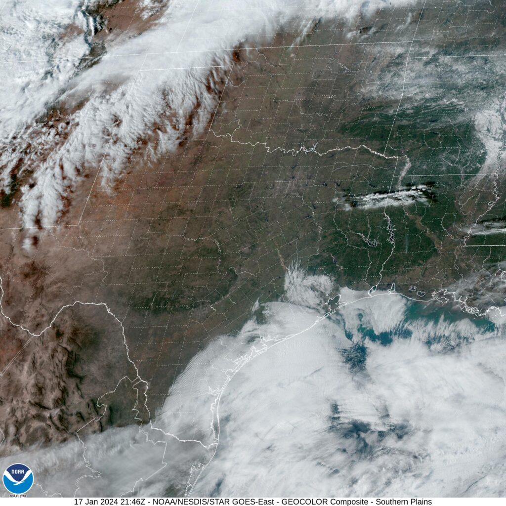
A business trip this week. Why a business trip? Because it will start on Monday and last through Thursday. Expect it to cover 2074 miles at a pace of a little more than 69mph, which will get us a healthy 553 miles a day for the first three days of our trek. And not to spoil anything, but the weather does look good.
DAY ONE (Monday)

High pressure is back out there, everyone. it’s dominating the majority of the country this week, and the southwest US is no exception. The hardest part of the day will be leaving San Luis Obispo (because it’s so lovely) but we will arrive with no concerns at the Crookton Road exit, east of Seligman, Arizona.
DAY TWO (Tuesday)
Nothing is really going to change on Tuesday, except for our location. We will see some rising and falling terrain, but not any real weather change. Heck, we’ll even be on I-40 the whole way. We’ll make it to Tucumcari, New Mexico, before this easy day concludes.
DAY THREE (Wednesday)
Our good luck continues on Wednesday, as we spend much of the day in a calm, quiet Texas. The road will be clear, but be wary of traffic in Dallas, because it will have been a while since we saw any. The jet will start forming a kink south of Texas, and that can portend bad news for the atmosphere, but it won’t yet, not on Wednesday. We stop in Canton, Texas for one last pit stop.
DAY FOUR (Thursday)
The trough will indeed start stirring up some wet weather, but it won’t emerge until after we are on our way into Mississippi. The rain will be over Mexico, low pressure in west Texas, and mostly sunny skies in Hattiesburg.

I know there is a “North” in the name, but you don’t usually think of sub-freezing temperatures in Charlotte, North Carolina. That’s exactly what they saw on January 19th and 20th, though. Most of the 20th, in fact, was below freezing, with highs remaining in the mid-30s. It’s been an active month, and post frontal cooldowns are becoming many in the southeast are getting used to enduring. The Weather Channel and Accuweather tied for the top forecast, missing out, as everyone did, on the end of the rain associated with that cold front sweeping through. No rain on the 19th.
Actuals: January 19th, High 52, Low 29
January 20th, High 33, Low 20
Grade: B-C
This has been a busy January. Not only have we had a lot of forecasts, but they have all been during or very close to significant weather. The real test will be if we can keep it up with a forecast in California.
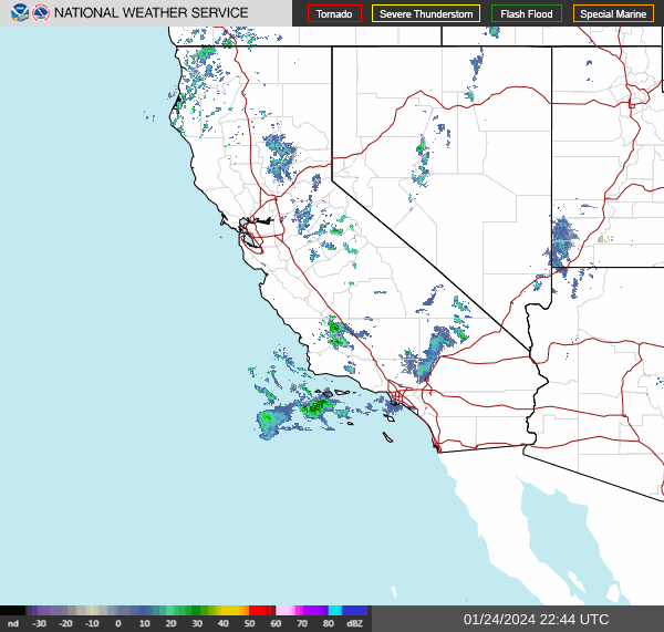
AT 256PM, PT, San Luis Obispo was reporting a temperature of 58 degrees with overcast skies. A weak wave was moving through the Pacific Northwest, and sweeping a mid level cold front as far south as Point Conception. There were scattered showers through out the region, though right now, the heaviest precipitation is diminishing between San Luis Obispo and Bakersfield, with another batch closer to Los Angeles.
The rain is expected to linger in the area, though mostly inland from San Luis Obispo and south towards the LA Basin. The onshore flow behind the boundary will mean that San Luis Obispo will see some overcast through the day Thursday even if they don’t get much more rain. An advancing ridge should bring clearer skies to end the work week.
Tomorrow – Mostly cloudy, with a few breaks late. Early sprinkles, High 64, Low 50
Friday – Sunny with a bit of morning haze, High 72, Low 45
TWC: Tomorrow – Intervals of clouds and sunshine. High 67, Low 53
Friday – Intervals of clouds and sunshine. High 72, Low 47
AW: Tomorrow – Low clouds giving way to sunshine High 70, Low 55
Friday – Partly sunny and pleasant High 74, Low 48
NWS: Tomorrow – Patchy drizzle before 10am. Mostly cloudy, then gradually becoming sunny, High 65, Low 51
Friday – Mostly sunny High 69, Low 49
WB: Tomorrow – Mostly cloudy in the morning, then sunny. Patchy drizzle in the morning, High 67, Low 53
Friday – Partly cloudy, High 71, Low 47
WN: Tomorrow – Partly cloudy with patchy drizzle, High 66, Low 51
Friday – Partly cloudy, High 69, Low 49
CLI: Tomorrow – Sunny, High 69, Low 50
Friday – Mostly cloudy, High 73, Low 48
It IS raining in southern California, but things are improving quickly. Now, here is the ultra rare SOCAL RADAR!
Even, unfortunately, the mistakes are bigger in Texas. Temperature behind last week’s system did not react quite how anyone had anticipated in Dallas. Every outlet thought it would be as cool as freezing, or nearly there on the 18th, last Thursday, and it only dipped as low as 40. This warmer base meant that the high on Friday was also significantly warmer than expected as well, with the midnight high coming in at 45, when nobody expected anything better than the mid-30s. It wasn’t a good forecast, for sure, but The Weather Channel ultimately came away with the top score.
Actuals: Thursday – High 58, Low 40
Friday – High 45, Low 26
Grade: C
While the rest of the country was able to dry out after a system moved through the middle of the country about this time last week, Lansing was left in a lurch. After the warm start to the season, Lake Michigan still has open water, and deep cold pool with west winds whipping across the Lake settled in. The fetch wasn’t deep enough to substantively affect Lansing, but overcast and cold temperatures still enveloped the capital city. There were flurries at times both days, which ultimately awarded the top forecast to the Weather Service and WeatherNation.
Actuals: January 15th, .01 inches of moisture in snow, High 11, Low -4
January 16th, .01 inches of moisture in snow, High 9, Low 2
Grade: B-C
Oh, man, when we looked last week in Dallas, things were looking to get a little bit better. Now when I check in after the weekend expires, they are mired in some low ceilings and visibilities in the wake of a weak system that brought chilly rain to the region to start the week. At least they didn’t get the ice they got in Oklahoma City and Kansas City!
It’s a Carolina kind of day here at Victoria-Weather, after the earlier verification in South Carolina. What will we look forward to in the coming days in North Carolina?
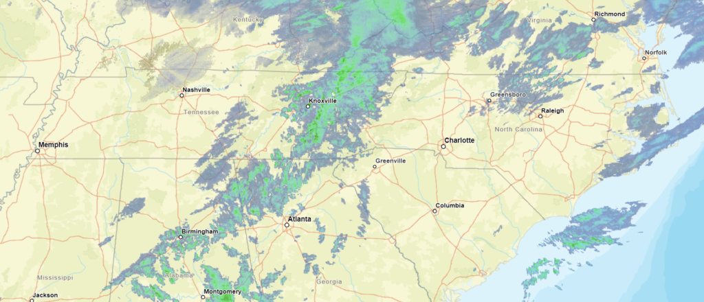
At 952PM, ET, Charlotte was reporting a temperature of 42 degrees with overcast skies. Coastal North Carolina finds itself between a strong offshore low, and a wave sweeping in from the Great Lakes. The wave is ushering in cold air, while the strong low is inducing more rain and convective activity. The Great Lakes feature is dragging a cold front across the Appalachians right now, with rain and some sleet reported in the far western reaches at Andrews of the state. Not much, if any of this moisture will descend the mountains into Charlotte, but that doesn’t mean a dry 24 hours for the Queen City.
Light precipitation is going to linger in the area through most of the morning as the offshore low intensifies and adopts the clipper moving in from the northwest. While most of the moisture will be spent in the mountains, the cold air will not be. This will be a prime opportunity for cold air damming, but temperatures will still be chillier for the beginning of the weekend. Cold high pressure will trap the chilly temperatures
Tomorrow – A bit of drizzle, then clearing with temperatures dropping, High 48, Low 28
Saturday – Clear but quite cold, High 33, Low 18
TWC: Tomorrow – Partly cloudy skies with gusty winds developing during the afternoon. (early rain) High 48, Low 30
Saturday – Sunny. High 34, Low 20
AW: Tomorrow – Mostly cloudy; breezy in the afternoon (Early rain) High 49, Low 29
Saturday – Plenty of sunshine, but colder High 34, Low 22
NWS: Tomorrow – Mostly sunny, Early rain, High 47, Low 26
Saturday – Sunny High 33, Low 18
WB: Tomorrow – Partly sunny early, then clearing, (early rain) High 47, Low 28
Saturday – Sunny, High 33, Low 23
WN: Tomorrow – Partly cloudy (early rain), High 47, Low 25
Saturday – Sunny, High 33, Low 18
CLI: Tomorrow – Sunny (early rain) High 50, Low 27
Saturday – Sunny, High 36, Low 19
A pretty chilly day for Charlotte, shortly after a pretty chilly forecast for Dallas. I should note, that everyone had rain through about 5AM, but that doesn’t translate to their daily forecast. Here comes the rain on radar.
During last week’s version of the interminable series of storm systems this month, we visited Florence after a line of thunderstorms had brought severe weather to the city earlier in the day. There was a little bit of light rain that trailed the line that arrived a little bit after midnight that altered the verification a bit, but aside from that, post frontal forecasting is pretty easy. Victoria-Weather earned our first forecast W of the year, up against strong competition.
Actuals: Wednesday January 10th, .03 inches of rain High 52, Low 37
Thursday, January 11th, High 57, Low 33
Grade B-C
The weather of Texas isn’t supposed to be like it’s been. Alas, it is January, and we have a robust, strong jet stream leading to an equally strong, robust surface pattern. Let’s continue to discuss.
At 253PM, CT, Dallas was reporting a temperature of 41 degrees with fair skies and a brisk south wind. High pressure has set up in the southeastern US, which is bringing about the southerly flow, however with the strong jet structure, another trough emerging is leading to a transient pattern, and todays blustery conditions.
The next upper level trough will have little reflection in terms of a well structured cyclone or precipitation, but the cold air mass will be defined and strong as it presses southward. It will remain dry and snow free in the MetroPlex, however even colder air will head south for the region on Thursday night.
Tomorrow – Mostly sunny, breezy, High 53, Low 32
Friday – Chilly in the morning, partly cloudy, High 37, Low 27
TWC: Tomorrow – Partly cloudy skies. High 57, Low 33
Friday – Sunny, High 36, Low 25
AW: Tomorrow – Warmer with plenty of sunshine High 55, Low 30
Friday – Breezy in the morning; otherwise, very cold with plenty of sunshine; after a brief break, very cold air returns High 36, Low 23
NWS: Tomorrow – Sunny, High 56, Low 32
Friday – Sunny, High 36, Low 24
WB: Tomorrow – Sunny, High 51, Low 31
Friday – Sunny, Much cooler, High 36, Low 28
WN: Tomorrow – Mostly sunny, High 56, Low 32
Friday – Sunny, High 36, Low 24
CLI: Tomorrow – Sunny, High 55, Low 33
Friday – Sunny, High 39, Low 23
Brr! That’s a cold Friday for most people, and especially in Texas. At least there isn’t the added challenge of driving in the snow or ice this time around. Clear skies overhead for the Lone Star State at this time.