It’s been a tough week in eastern Kentucky, as it became a focal point for heavy rain as a slow moving boundary left even slower moving torrents of rain across the state, ultimately leaving dozens dead in flash flooding, and countless more with their lives turned upside down. The news from the area continues to get worse as we find out more, and we continue to keep residents in our thoughts.
Often when rain becomes centered on one spot, as it did in Kentucky, the threat for scattered showers away from that main area diminishes. Such was the case on Tuesday and Wednesday, when Atlanta, which had been forecast for some light showers on either of those two days, successfully avoided precipitation. Temperatures climbed a couple of degrees warmer than anyone had, but it was a generally tightly clustered verification. The Weather Channel and WeatherNation were strange bedfellows, tying for the top spot. Actuals: Tuesday – High 91, Low 75 Wednesday – High 92, Low 75
We are headed to one of the more important weather hubs in the country, along with Silver Spring, Maryland and Oklahoma City. Atlanta is home to many weather focused corporations, notably The Weather Channel, and we are coming for you, TWC!
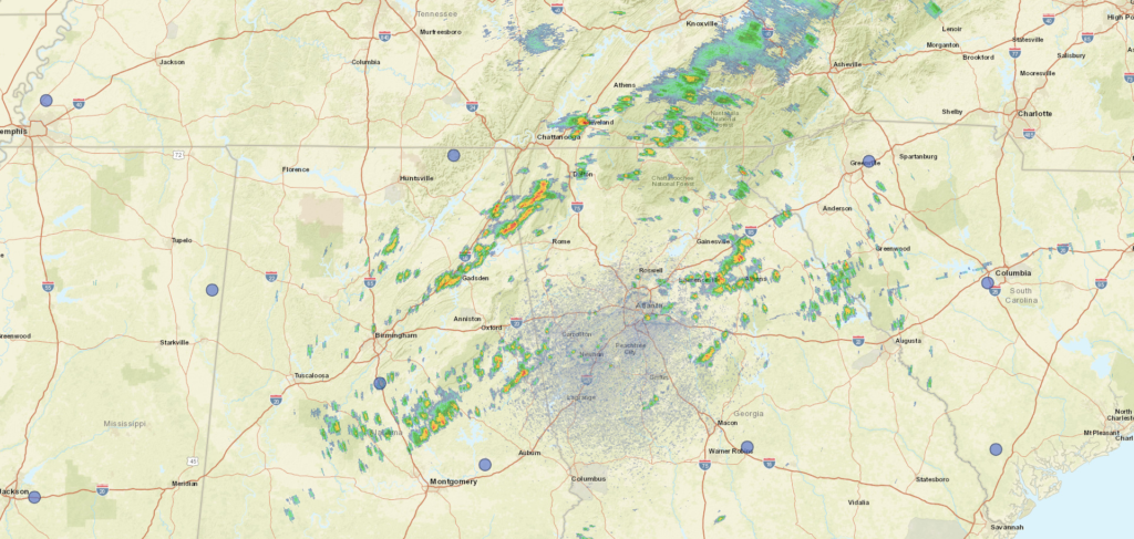
At 1252PM, ET, Atlanta was reporting mostly cloudy skies with a temperature of 87 degrees. Bands of isolated thunderstorms are stretched across North Georgia, with one particular cluster near Athens, Gainesville and Lawrenceville, and a stronger line north of Rome. There is one cell on the southeast side of Atlanta, but otherwise, there is a dry window encompassing the Atlanta area. There is an area of low pressure over Quebec dangling a cold, becoming stationary front through the Tennessee Valley, and along that boundary is a perturbation centered near the District of Columbia. This complicated set up is helping to tap into the moisture in the southeast, and touching off the banding showers and thunderstorms in north Georgia this afternoon. The threat for storms in and around Atlanta will abate a bit this afternoon, as the activity becomes more focused along the boundary to the north. That boundary is expected to remain intact even as the low over Quebec deteriorates. A second surface low moving out of the High Plains into the Great Lakes will pull the boundary a bit to the north by Wednesday, presenting a dry mid-week in Atlanta. Of course, one last perturbation along the front before it moves northward will bring some scattered showers to Atlanta first on Tuesday evening. Tomorrow – Scattered clouds with a chance for isolated showers and storms, High 88, Low 73 Wednesday – Scattered to mostly cloudy. A bit warmer, High 90, Low 73
TWC: Tomorrow – Variable clouds with scattered thunderstorms. High 89, Low 74 Wednesday – Sunshine and clouds mixed High 93, Low 73
AW: Tomorrow – Humid with intervals of clouds and sunshine High 87, Low 73 Wednesday – Partly sunny and humid; a thunderstorm in spots late in the afternoon High 91, Low 73
NWS: Tomorrow – A 50 percent chance of showers and thunderstorms, mainly after 11am. Partly sunny, High 88, Low 74 Wednesday – A 20 percent chance of showers and thunderstorms. Mostly sunny, High 91, Low 73
WB: Tomorrow – Partly sunny with a chance of showers and thunderstorms, High 87, Low 74 Wednesday – Mostly sunny with a slight chance of showers and thunderstorms, High 91, Low 74
WN: Tomorrow – Partly cloudy with chance of storms, High 89, Low 73 Wednesday – Partly cloudy, High 92, Low 73
FIO: Tomorrow – Humid and mostly cloudy throughout the day. High 86, Low 74 Wednesday – Humid and partly cloudy throughout the day. High 88, ow 75
Pretty hot couple of days in Georgia, but all that moisture around, the mountains, it keeps it from triple digits most of the time. Rain shield over Atlanta has been activated.
Some drives are pretty easy to navigate, like this one, which will take us entirely via interstate from Georgia to Arizona. It will take us three days to cover the ground, specifically 1,733 miles of ground. The final day will last 10 hours, with the first two covering 533 miles, all at a pace of about 66.5mph. Thanks a lot, traffic.
DAY ONE (Wednesday)
Atlanta, Georgia
The weather in the south is looking brilliant. High pressure is rising from the south, not one of those Arctic domes of high pressure, so it won’t be terribly cold, either. We’ll slice through the south, from Atlanta to Grambling, Louisiana with ease. Just a terrific day for driving.
DAY TWO (Thursday) The drive will continue to be fairly pleasant on Thursday, but it will be warmer than the drive on Friday. This is because of southerly flow caused by an area of low pressure charging from northern Mexico into the southern Rockies. It’s going to be a big deal for a lot of people late this week, but let’s not worry about that now. We will get to Big Springs and the Permian Basin after a long drive through more than half of Texs.
DAY THREE (Friday) It’s going to be a bit different as we get going on Friday. After a night of rain and a few embedded thunderstorms, the last vestiges of precipitation will nearly be past Big Springs as we get going, and we should be out of it soon if it’s not done already. Cold air will be rushing in through eastern New Mexico into Texas. There will be plenty of sunshine, however, so getting out of the car for gas will be a real shock to the system. Snow will be falling in the mountains along the New Mexico-Arizona border, north of our route. We should make it into a surprisingly pleasant Tucson (temperatures, I mean, the people are always nice, I’m sure) late in the afternoon, just in time for dinner.
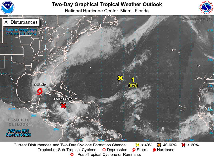
Two weekends ago, meteorologists were diligently watching the Gulf of Mexico in anticipation of the development of Tropical Storm Delta. Delta did develop into a hurricane and moved through the Mississippi Delta (no relation) and towards the Great Lakes. It was tough to think of the tropics before that in Atlanta, as the temperatures, particularly the morning lows around the 50 degree mark, were positively autumnal. The Weather Channel did earn victory on the forecast. They’ve been in Atlanta getting pumpkin spied lattes for a couple weeks now, and surely had some more intimate knowledge of the conditions. Actuals: October 5th, High 77, Low 50 October 6th, High 79, Low 51
We’re driving southward today, trying to get to Atlanta before Hurricane Delta finds the coast. We should be able to do it, as our drive will only last a day and cover 505 miles, doing so at a pace of a little over 62mph. Try to limit stops and use hand sanitizer!
Terre Haute, Indiana
Delta hit the Yucatan this morning and is spilling into the Gulf tonight. It pulsed down before it hit Cancun, and will be weakened when it arrives in the Gulf. Still, it’s previous intensity, and further ramping up will entrap nearby atmospheric moisture, and while the eastern US is under high pressure, the sea breezes will be turned off too. The entire drive from Terre Haute to Atlanta will be under mostly clear skies, with seasonable warmth.
All right, Weather Channel, we’re coming for your back yard.
At 852PM, ET, Atlanta was reporting a temperature of 66 degrees with mostly cloudy skies. Tropical Storm Gamma was interfacing with low pressure in the Gulfstream, with clouds streaming across the southeastern United States. Atlanta was at the northern end of of the band of clouds, but Atlanta was the only place that was reporting anything close to overcast conditions. High pressure is building into the Plains, and that will build into north Georgia as well, rendering the next two days quite pleasant. As Gamma unfurls, there might be a band of showers over central Georgia on Tuesday morning, but nothing well organized or long lived will transpire. Over the long term, Tropical Depression 26 bears monitoring not only for the Gulf, but specifically for the Atlanta area by next week. Tomorrow – Partly cloudy, High 78, Low 55 Tuesday – Sunny, High 79, Low 57
TWC: Tomorrow – Sunny skies, High 76, Low 52 Tuesday – Partly cloudy, High 78, Low 55
AW: Tomorrow – Pleasant with plenty of sun, High 78, Low 53 Tuesday – Pleasant with plenty of sun, High 78, Low 57
NWS: Tomorrow – Sunny High 77, Low 53 Tuesday – Sunny High 76, Low 55
WB: Tomorrow – Sunny High 75, Low 53 Tuesday – Sunny High 77, Low 56
WN: Tomorrow – Mostly sunny, High 77, Low 55 Tuesday – Mostly sunny, High 76, Low 54
FIO: Tomorrow – Clear throughout the day. High 79, Low 54 Tuesday – Clear throughout the day. High 78, Low 57
Atlanta looks ok today, but as I said, the Gulf bears monitoring.