Harrisonburg, Virginia

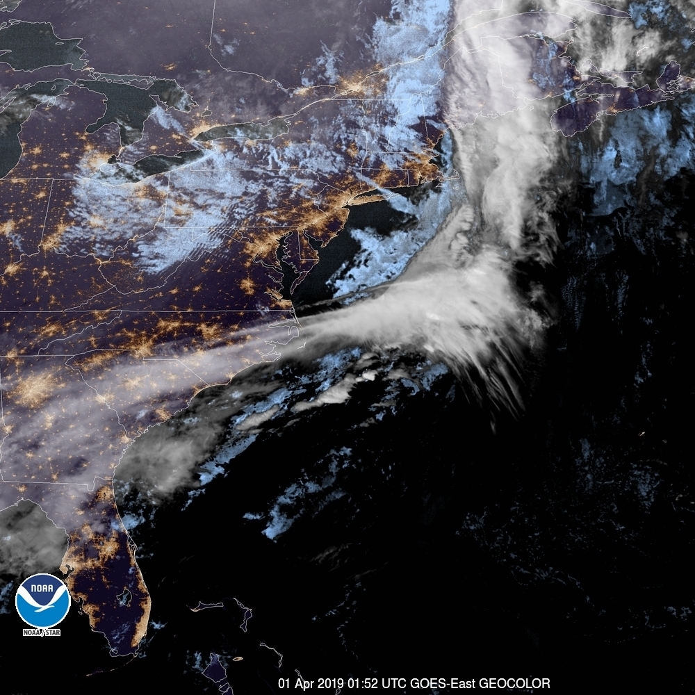
We’re taking our situation to the lee side of the Appalachians. It doesn’t seem like a heavily populated area, but there are many small cities from Winchester in the north to Charlottesville, Roanoke and Blacksburg with Harrisonburg in the middle.

At 935PM, ET, Harrisonburg was reporting a temperature of 37 degrees with clear skies. There was a brisk flow off the mountains, with some overcast over West Virginia, but it was chasing low pressure that had shifted off shore.
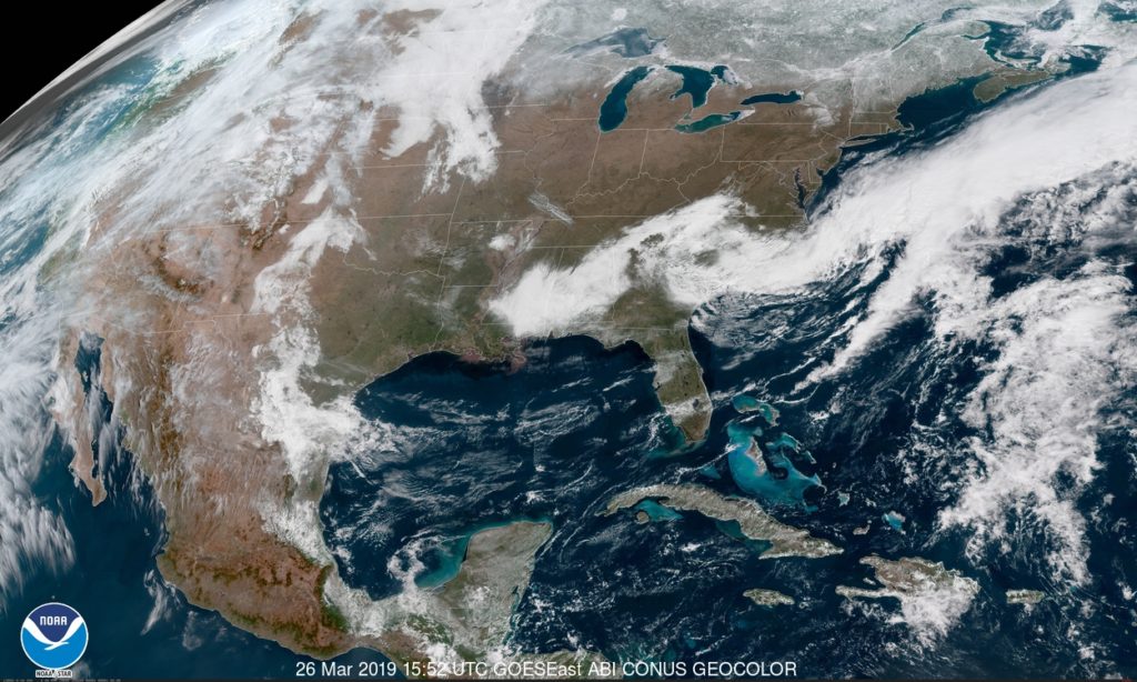
The area of low pressure over the Canadian Maritimes that was trailing the cold front was parented by a trough with a tail into the Great Lakes, however the jet had dug all the way to the Gulf of Mexico. Low pressure will develop at the base of the trough and move up the Gulf Stream. It will remain well off shore, and high pressure will remain in place over Harrisonburg, but the reinvigorated flow will keep Harrisonburg dry and cool to start the week.
Tomorrow – Mostly sunny, High 51, Low 25
Tuesday – Increasing clouds, High 52, Low 25

TWC: Sunny, along with a few afternoon clouds High 50, Low 26
Tuesday – Cloudy. High 50, Low 28

AW: Tomorrow – Plenty of sun high 50, Low 27
Tuesday – Some sunshine giving way to clouds High 50, Low 26

NWS: Tomorrow – Sunny, High 48, Low 25
Tuesday – A slight chance of rain after 2pm. Partly sunny, High 51. Low 29

WB: Tomorrow – Sunny, High 49, Low 30
Tuesday – Mostly sunny in the morning then becoming mostly cloudy, High 48, Low 31

WN: Tomorrow – Sunny, High 48, Low 25
Tuesday – Partly cloudy with isolated showers, High 51, Low 29

FIO: Tomorrow – Partly cloudy starting in the afternoon. High 52, Low 32
Tuesday – Mostly cloudy throughout the day. High 49, Low 32

The Weather Service and WeatherNation are leaning into the NAM today, but everyone else is a bit more optimistic. Satellite tonight shows off a pretty clear night in Virginia.

Modesto gives us all problems

There were two problems with the verification for Modesto. First, the airport on the south end of town didn’t properly maintain their records. Second, if they had, I’m not sure we would have been terribly successful. Temperatures generally ran much cooler than we had expected in the overnight hours. Maybe they would have been warmer at the proper airport, but I’m not really convinced. The temperatures were just too far off. We can still crown a winner, though, and we will. Accuweather had the top forecast for the day.
Actuals: Wednesday .02 inches of rain, High 69, Low 47
Thursday – .08 inches of rain, High 66, Low 41

Grade, C-D

West Virginia Warm up

See, we’re definitely back! Now we even have the alliterative verification titles and everything. This is certainly a fitting one for Morgantown, where temperatures reached a balmy 65 degrees yesterday, and without any of the rain that had been a potential. The springtime warmth comforted The Weather Channel, especially, as they claimed victory.
Actuals: Wednesday – High 60, Low 23
Thursday – High 65, low 39

Grade: B-C

Can flooding be slowed?

There are two things that we can see long term that help indicate whether or not flooding is in the future. Is there a lot of snowpack ready to melt? This year, that was a firm yes. Second, is there flooding upstream? For places from Missouri south to the Gulf of Mexico, the answer is also yes. Residents are already preparing, especially on the banks of the Missouri River.

A short term impact on flooding, as in one that can arrive with much less advance warning, is rain. Flash flooding is the result of more local rains, but river flooding can be exasperated by fresh rain fall. It can also be advanced by a rapid warm up, especially if coupled with rain. This was the problem in South Dakota, Iowa and Nebraska earlier this month.

Fortunately for millions of residents, the thaw at the headwaters of the Mississippi was methodical, with refreezing overnight, and a more tempered warm up. The Mississippi and many of it’s tributaries are high, but municipalities in Minnesota and Iowa were able to anticipate the rising waters, for the most part, and have been able to stave off major issues.

And although the CPC continues to have a wetter than average beginning to April and spring season in the forecast, the ground is beginning to thaw and most of the melting above ground is complete. The Mississippi is cresting in Minnesota and starting to recede, with a major crisis averted. The good news in Nebraska, Iowa Kansas and Missouri is that any potential catastrophes aren’t going to loom more ominous than they already do.

The water was so high upstream in Nebraska and South Dakota that downstream flooding through Kansas City couldn’t be averted (though it wasn’t as bad as feared) and communities between Kansas City and St. Louis will need to be aware too, however the graciousness of Mother Nature, allaying the melting process and keeping the Midwest dry for several days, and the lower Mississippi Valley can breathe a sigh of relief.

Worcester, Massachusetts

Wow! Another forecast! And every single part of this city name is really tough to spell!

AT 354PM, ET, Worcester was reporting a temperature of 42 with fair skies. there were a few stray clouds across New England, but high pressure over the region ensures that they won’t amount to much.
The ridge is angled north and south along he Appalachians, and will be easily moved by a cold font appended to a deep area of low pressure over Hudson Bay. The boundary will sweep in fairly early in the day on Friday, leaving a low overcast day marked by a bit of light rain throughout the day.
Tomorrow – Mostly sunny, High 48, Low 26
Friday – Overcast with rain at times, High 54, Low 36

TWC: Tomorrow – Generally sunny despite a few afternoon clouds. High 51, Low 28
Friday Cloudy (early rain).,High 59, Low 39

AW: Tomorrow – Sunshine mixing with some clouds High 50, Low 27
Friday – Variable cloudiness High 56, Low 38

NWS: Tomorrow – Sunny, High 51, Low 28
Friday – A slight chance of showers after 1pm. Mostly cloudy, High 58, Low 39

WB: Tomorrow – Sunny, High 49, Low 27
Friday – Mostly cloudy, High 7, Low 38

WN: Tomorrow – Mostly sunny, High 51, Low 29
Friday – Mostly cloudy with isolated showers, High 58, Low 39

FIO: Tomorrow – Mostly cloudy starting in the afternoon. High 52, Low 30
Friday – Overcast throughout the day. High 56, Low 42

Look how empty this satellite is! Unfortunately, there will be a bit of overcast on the way. Whether or not that includes rain remains to be seen.

Modesto, California

Two forecasts in a day? I find that the only way this makes sense is to hit both sides of the country.

At 953PM, PT, Modesto was reporting a temperature of 61 degrees with overcast skies. There was a little bit of rain over San Francisco, and dew points were nosing into the low 50s. If there is any clearing tonight, low lying areas are likely to fog in.
A persistent area of low pressure over the Pacific is going to continue to generate a pipeline of moisture into northern California. Snow is expected in the mountains, with rain a persistent matter of fact for Modesto for the next two days. There really won’t be a change to the pattern, as this trough won’t progress, but rather dampen and fade away, making Thursday a bit less rainy.
Tomorrow – Rain, High 66, low 54
Thursday – Scattered showers, becoming less widespread, High 66, Low 48

TWC: Tomorrow – Rain showers in the morning with numerous thunderstorms developing in the afternoon. High 66, Low 55
Thursday – Partly cloudy skies during the morning hours will give way to occasional showers in the afternoon. High 64, Low 47

AW: Tomorrow – Cloudy, spotty showers; cool High 67, Low 54
Thursday – A morning shower; otherwise, times of clouds and sun; cool High 65, Low 46

NWS: Tomorrow – A chance of showers and thunderstorms, then showers and possibly a thunderstorm after noon. High 67, Low 55
Thursday – A chance of showers, then showers likely and possibly a thunderstorm after noon. Partly sunny High 65, Low 48

WB: Tomorrow – A chance of rain showers and a slight chance of thunderstorms in the morning then rain showers and a slight chance of thunderstorms in the afternoon. High 65, Low 55
Thursday – Mostly cloudy. A chance of rain showers in the morning then rain showers likely and a slight chance of thunderstorms in the afternoon. High 63, Low 48

WN: Tomorrow – Mostly cloudy with scattered showers, High 67, Low 55
Thursday – Mostly cloudy with light showers, High 67, Low 55

FIO: Tomorrow – Light rain in the afternoon. High 64, Low 51
Thursday – Partly cloudy starting in the morning, continuing until night. High 64, Low 46

Everyone seems to be on the same page, or would be, if Weathebug hadn’t filled it all up. Radar is active in the North Bay!

Morgantown, West Virginia

Hi! Morgantown is the home of the University of West Virginia, but is actually way closer to Pittsburgh than any of the other population centers of West Virginia. Does that influence the weather in any way? Almost certainly not!

At 1253PM, Morgantown was reporting clear skies and a temperature of 39 degrees. Dry air was pushing into the area as a strong ridge of high pressure was settling into the Great Lakes. There was still a tumultuous pattern at the upper levels, but it was not reflected at the surface.
The machinations at the very top of the continent will ultimately bear watching for most of the northern part of the country. An area of low pressure developing in the Northwest Territories, headed into Nunavut will dangle a cold front into the Great Lakes through midweek, headed towards the Appalachians for the end of the week. It will be motivated by a surprisingly strident batch of cold air, though most of the local moisture will come from the Lakes. All this is to say the boundary, despite the cold air, will be slow moving and not terribly rainy. Morgantown should be in the clear until Friday.
Tomorrow – Sunny, High 55, Low 25
Thursday – Increasing clouds, but warmer, High 67, low 41

TWC: Tomorrow – Partly cloudy skies. High 57, Low 26
Thursday – Mainly cloudy. High 64, Low 39

AW: Tomorrow – Plenty of sun; milder High 58, Low 27
Thursday – Partly sunny; breezy, mild High 67, Low 38

NWS: Tomorrow – Sunny, High 56, low 27
Thursday – A slight chance of showers after 2pm. Mostly sunny, High 66, Low 36

WB: Tomorrow – Sunny, High 55, Low 27
Thursday – Partly cloudy, A slight chance of showers in the afternoon, high 64, Low 39

WN: Tomorrow – Mostly sunny, High 57, Low 27
Thursday – Partly cloudy with isolated showers, High 66, Low 36

FIO: Tomorrow – Partly cloudy starting in the morning, continuing until afternoon.High 59, Low 30
Thursday – Mostly cloudy starting in the morning. High 65, Low 41

Even if it does rain, that’s a pretty great forecast. Tranquil today.

The Hopeless Optimist

I thought we had turned a corner. On the winter, if there is a shadow of a doubt, leave precipitation in the forecast. On the summer, it’s easier to dodge rain drops even if it looks like storms are looming on a given day. Alas, I thought Lafayette was in the clear over this weekend with a short wave trough approaching. I was the only one who felt that way, but I felt really good about it. Of course, you know how this ends. It ends with Lafayette wet. Victoria-Weather could have secured victory if those .06 inches of rain hadn’t fallen, but instead, it was The Weather Channel and WeatherNation who split honors.
Actuals: Saturday, High 53, low 19
Sunday – .06 inches of rain, High 53, low 38

Grade: B-C

Video Round up (And the forecaster of the Month)

While we’ve been knocked out of commission and also trying to get caught up with life, the weather has gone on unabated. While most of the country has been bouncing back from a grueling winter, our first stop takes us to Nebraska and South Dakota, which are undergoing unprecedented flooding, thanks primarily to snow melt, which has led to dam breaches, particularly on the Missouri, Elkhorn and Niobara Rivers.

These floods pale in comparison, somehow, and amazingly, to the catastrophic landfall of a cyclone near Beira, Mozambique. Cyclone Idai, all told will end up killing thousands in Mozambique, Zimbabwe and Malawi. Part of the problem, as is often the case with disasters in the third world is a failure of infrastructure, but another is that Mozambique has a natural barrier – Madagascar – that usually saves the country, and the region was less experienced with such catastrophes. Idai brought its strongest winds to Beira, a city of 300,000, then meandered through southeast Africa, with floods sweeping inland areas, driving up the death toll.

After all that, it’s tough to move to a different, more positive tale, but here it is” We were able to maintain our records, even if we weren’t able to keep our site up and running. We can say for sure that Accuweather had the top month back in February, which seems wild, since A) I can’t believe we are still thinking about February and B) they did it without much success on winning individual forecasts. Consistency! Congrats to Accuweather

Month wins
Weatherbug2.58
WeatherNation1.58
Victoria-Weather1
Forecast.io1
Accuweather0.33
The Weather Channel0.25
National Weather Service0.25
OutletMonth winsyear wins
Weatherbug2.583.58
Victoria-Weather13
Forecast.io13
National Weather Service0.252.25
WeatherNation1.581.58
Accuweather0.331.33
The Weather Channel0.251.25