All right, let’s take a trip! It’s only going to be a 7 hour trip through the mountains of eastern Kentucky and West Virginia between our two end points on this Sunday journey. I can definitely say that these 472 miles would have been a lot more interesting today or yesterday, but alas, we try to avoid thunderstorms when driving.
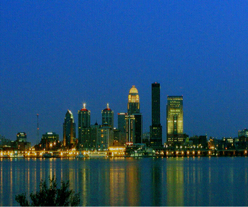
Louisville, Kentucky
Low pressure has really figured itself out in the Gulf Stream, and the cold front associated with it left a healthy stripe of wind damage reports from the Delmarva to the Smokey Mountains. Already today, the heaviest weather has remained south of our route, and northerly flow will remain in place on Sunday over the area surrounding West Virginia. The feature is strong enough, and the atmosphere is rich enough that there might be a few stray showers riding those north winds as we head towards western Maryland, but the most pleasant weather the region has seen in a while with only passing clouds will define the majority of the day.
Hello, and good evening, I hope you weren’t up waiting fore this late night forecast. It’s here anyway.
At 1253AM, ET, Cumberland was reporting a temperature of 78 degrees with clear skies. Cumberland was lucky to evade a round of very heavy thunderstorms earlier today, which brought strong winds to West Virginia and northern Virginia, as well as parts of eastern Maryland, but left western Maryland unencumbered. All these storms have been running along a slow moving cold front that is expected to start to resemble a continuous bowing cold front, running from the Chesapeake to the Mid-Mississippi Valley. The thunderstorms along the boundary will start to organize it’s southward march by tomorrow afternoon. There is a mass of thunderstorms presently moving eastward in the southern Great Lakes that will be ongoing through the morning, and may delay the southerly turn a bit. The change in direction and redevelopment of activity will likely limit the potential severity of thunderstorms on Saturday for Cumberland, though a gust of wind or hail could be seen in the mid afternoon. Cold – relative to what has been seen – air will press in to make Sunday a satisfying conclusion to the weekend. Tomorrow – Scattered showers and thunderstorms, a threat for severe storms, High 90, Low 69 Sunday – Mostly sunny, High 86, Low 65
TWC: Tomorrow – Thunderstorms likely in the morning. Then a chance of scattered thunderstorms in the afternoon. Gusty winds and small hail are possible High 89, Low 71 Sunday – Sunshine and clouds mixed. A stray shower or thunderstorm is possible. High 86, Low 67
AW: Tomorrow – Mostly cloudy and humid with a shower and thunderstorm; thunderstorms can bring flash flooding and localized damaging wind gusts High 90, Low 70 Sunday – Less humid with intervals of clouds and sun High 87, Low 69
NWS: Tomorrow – Scattered showers and thunderstorms before 8am, then scattered showers between 8am and 11am, then scattered showers and thunderstorms after 11am. Partly sunny, High 91, Low 71 Sunday – Isolated showers and thunderstorms. Mostly sunny, High 85, Low 67
WB: Tomorrow – Partly sunny with scattered showers. Isolated thunderstorms in the morning then scattered thunderstorms in the afternoon. High 86, Low 72 Sunday – Partly sunny in the morning then clearing, High 82, Low 70
WN: Tomorrow – Partly cloudy with scattered storms, High 91, Low 72 Sunday – Partly cloudy with isolated storms, High 85, Low 67
CLI: Tomorrow – Light rain showers, High 91, Low 70 Sunday – Sunny, High 86, Low 70
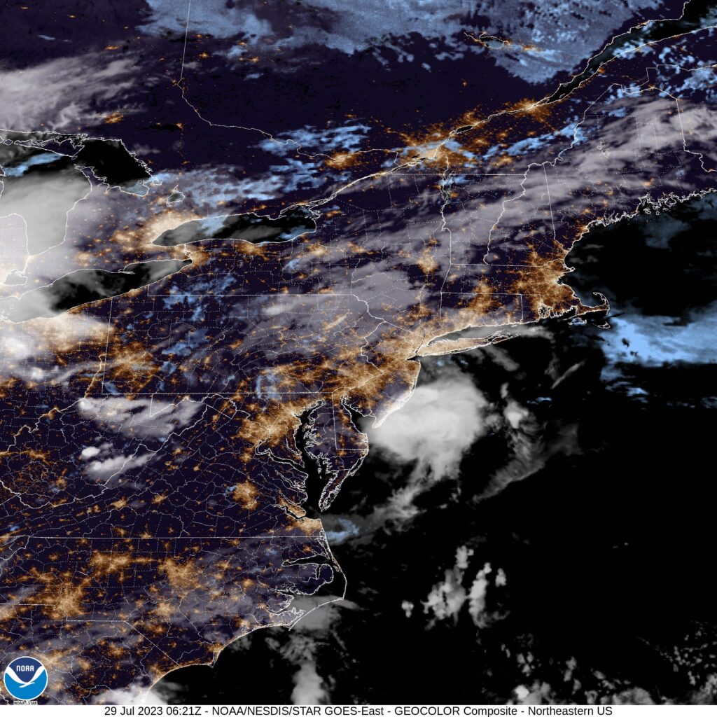
Some overnight imagery. Thunderstorms in Pennsylvania have tapered off, so not much to impress at this late hour.
I wrote recently about the flooding in eastern Kentucky and across West Virginia. Western Maryland, and specifically the city of Cumberland, for which we had a forecast last week, didn’t avoid the persistent soaking rains either. On the last day of February, Cumberland endured daylong rain that accumulated to over an inch. Fortunately, reports of flooding in Maryland weren’t as prolific, but this was enough rain to cause concern. Weatherbug was the top forecast for the end of the month. Actuals: Saturday – .03 inches of rain, High 47, Low 25 Sunday – 1.21 inches of rain, High 47, Low 40
West Texas to Western Maryland. I’m not sure there is a whole lot in common between the two locales, but maybe more than one would initially suspect. It’s a three hour drive, covering 1526 miles. We’ll move at a pace of about 67mph. The first two days will be the longer of the two at 536 miles, with the last day coming at only about a 7 hours drive. Barely anything to worry about.
Day One (Sunday)
Lubbock, Texas
Texas and Oklahoma, along with much of the rest of the middle of the country, are going to see a cold front move through overnight tonight. It’s going to really slow down south and west of St. Louis, and throughout a lot of the day, particularly after we cross the Red River north of Wichita Falls, we will be traveling in the wake of the front. There will be some wind and a little bit of rain on the back end of the feature, and I’m not fully confident we will ever get out of it on Sunday. Fortunately, after we arrive in Big Cabin, in northeastern Oklahoma, things will trend drier, and we won’t have to worry about it on the window all night. Boy, Big Cabin… I hope there is some sort of place to stay in Big Cabin.
DAY TWO (Monday) High pressure will build over the Great Lakes behind the system moving through overnight tonight, bringing cooler temperatures back to the area. Nothing extraordinary, mind you, but perhas back down to normal through Missouri and Illinois, before we pull in for the night in Monrovia, Indiana, the last exit before the Indianapolis metro.
DAY THREE (Tuesday) The cooler weather will rotate back up towards the North Pole, where it belongs, but the clear skies will remain. Some westerly wind may lead to a few clouds over the higher terrain in West Virginia, but it will be pretty more than impactful on our drive. Cumberland will be dry when we pull into town.
Let’s see what’s going on inland in Maryland tonight.
AT 955PM, ET, Cumberland was reporting a temperature of 35 degrees with light rain. That rain wasn’t likely to continue through the night. The back edge of this batch of rain, presently inundating the District of Columbia, was nearby. A more likely change, however, would be that the rain changes to snow before precipitation ceases. A trio of southwest to northeast jet streaks presently lies across the mid Atlantic, fostering an environment of instability, with light rain moving across the region. Some jet coalescence will occur in the next 12 hours, offering guidance for the activity in the area right now. It will jet off towards New England, while additional cyclogenesis will begin at the base of the trough, over the high Plains. As it drifts into the Upper Midwest, a well developed warm front will track through the area on Sunday morning. Fortunately, the warm air will arrive before the precipitation, and only rain is expected. Unfortunately, the system is going to occlude quickly, and the cold front will also drag itself across western Maryland by Sunday afternoon. Sunday, as a result, will be rainy throughout the day. Tomorrow – Wintry mix early, then clearing and mostly cloudy. High 56, Low 34 Sunday – Rain all day, High 51, Low 39
TWC: Tomorrow – Light rain early. A mix of sun and clouds in the afternoon. (early snow), High 58, Low 34 Sunday – Rain likely. Potential for heavy rainfall, High 49, Low 42
AW: Tomorrow – A passing morning shower; otherwise, mostly cloudy and not as cool (Early snow) High 58, Low 34 Sunday – Rain High 50, Low 40
NWS: Tomorrow – Rain, mainly before 1pm High 56, Low 38 Sunday – Rain, mainly after 7am. The rain could be heavy at times. High 53, Low 42
WB: Tomorrow – Patchy fog in the morning. Mostly cloudy with a chance of rain and freezing rain likely in the morning, then partly sunny with isolated rain showers in the afternoon. High 54, Low 36 Sunday – Rain, High 48, Low 41
WN: Tomorrow – Mostly cloudy with scattered showers, High 57, Low 34 Sunday – Mostly cloudy with rain, High 53, Low 40
FIO: Tomorrow – Light rain until afternoon. High 57, Low 34 Sunday – Rain throughout the day. High 53, Low 40
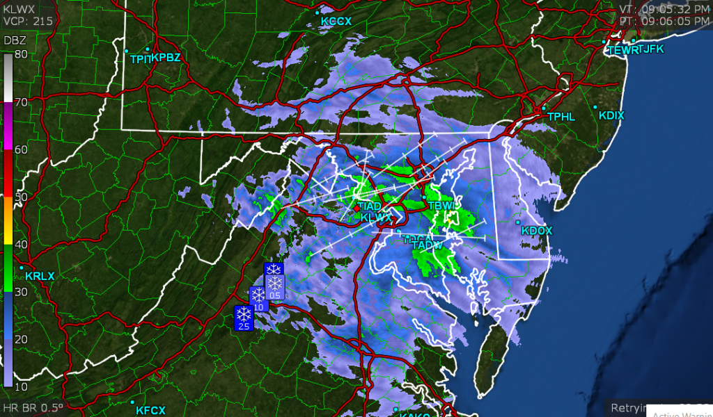
It looks pretty rainy in and around Cumberland this weekend. At least we are all used to being indoors by now, right? Here is the rain right now. Not showing much in Cumberland, but that is probably an effect of the mountains in western Maryland.
Look at this, two days in a row with posts! This time, we get to look forward to another week long road trip, this time headed eastward. It will take 5 days and 2648 miles to get from Napa to Cumberland. The trip this time will be divided evenly into our 8 hour segments, each at a 66.2mph and 529.6 miles a day. Some people just like symmetry.
DAY ONE (Wednesday)
Napa, California
The tropical Pacific doesn’t really impact the western US like the tropical Atlantic does, but there is a tropical feature, hurricane Elida drifting around out there. In truth, that’s the most interesting thing going on out there, as our drive from Napa to Wells, Nevada will be without incident.
DAY TWO (Thursday) I’m wary of guidance that shuts off the monsoon after it’s been going on for a while, which is what the models are showing right now. Whether I believe it or not, I think our route along I-80 during the day time will take us through the rest of Nevada and all of Utah without encountering a storm, before we arrive in Woodedge, Wyoming, which i about a half hour west of Laramie.
DAY THREE (Friday) Low pressure is going to be rising through Canada, drawing north a batch of hot humid air. This will mean a few thunderstorms developing in the high plains ahead of a cold front that will be moving towards the Upper Midwest. I wouldn’t be surprised if there are a few severe storms in and around Lincoln when we pull in for the night. Before that, though, it will be a mostly sunny, hopefully air conditioned day on the road in Nebraska,
DAY FOUR (Saturday) The derecho that blew through he Midwest yesterday followed I-80 from Des Moines to northern Indiana, not unlike our route on Saturday. Don’t be surprised to see some sheered warehouse roofs and freshly sawed stumps wherever we end up along that stretch. An area of low pressure developing in the Carolinas will do a good job of disrupting moisture flow to the Upper Midwest, so the cold front that will be in Minnesota on Friday won’t really be much of a concern. There may be a few clouds with some spots of rain, but nothing too well organized around the Quad Cities. We’ll stop for the night in Lake Station in northwest Illinois.
DAY FIVE (Sunday) That area of low pressure in the mid-Atlantic isn’t forecast to move anywhere this weekend. It seems as though moisture won’t filter west over the entirety of the Appalachians, but low level moisture and some patchy showers seem fairly likely as soon as we cross the Ohio River, but mostly cloudy skies are probably be fore that. This will be the worst drive of any through our trip, but at least we will be arriving in Cumberland!