I wrote the forecast for Fayetteville before I wrote the post about cold fronts failing to take hold in the center of the country. That should tell you something about how this forecast went. Sure, there was a weak boundary sinking through the area earlier this week, but I thought it would bring a bit of northerly flow and some more comfortable air to northwest Arkansas. Instead, temperatures went up by a couple of degrees as the temperatures simply reflected the amount of rain that was seen in the day. A heavy AM thunderstorm on Sunday helped temperatures stay below 90, while they climbed over that mark on Monday, a drier day. The top forecast was split between Accuweather and the Weather Service. Actuals: Sunday – .28″ of rain in thunderstorms, High 89, Low 73 Monday – .03″ of rain, High 92, Low 72
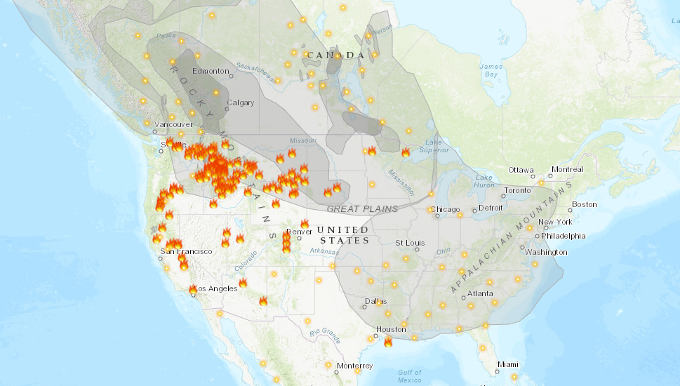
Another summer and we are plagued by wildfires. If there is any difference between this year and the last couple, it is that the bulk of the fire activity is in the northern Rockies, as well as in Alaska, rather than within the state of California. Surely, this is some relief to relatives of the Golden State, and it is definitely a good thing that the fire threat isn’t as imminent to as many people, however it is a burden for the rest of the country.
As this map, from Airnow.gov shows, there is smoke in the air for about 3/4th of the country. Air quality is below normal for all of those locations.
It is rare that the jet intercepts California during the summer, and it isn’t often that smoke can blanket the country as it is right now during a typical fire season. Also frustrating for many of the people getting smoked out right now, is that the flow bringing the smoke in is from the northwest. Were there no fires in the Pacific Northwest and particularly Alaska, the air would be cool and refreshing after a very hot month of July.
Smoke advisories continue to get extended for the region, as relief is not yet right around the corner. Fires, of course, need to be extinguished, but a more immediate source of relief would be a change in the prevailing pattern, but unfortunately, even that doesn’t look to change until at least late in the week.
Last week, Texas was still wrapping up a surprisingly cool start to summer. It was hot everywhere in the country, except in the southeast, and when we looked at Laredo, another round of onshore showers and thunderstorms was just wrapping up for the far southern part of the state. Most outlets had thunderstorms in the forecast for last Thursday, but they never materialized. Nevertheless, it was still cloudy enough that temperatures stayed below 100 one last day. It’s been a scorcher ever since, however. Accuweather had the best forecast for the last gasp of tolerable weather for south Texas. Actuals: Thursday, July 22nd – High 93, Low 75 Friday – High 101, Low 76
In many summers, I find myself rolling my eyes at other outlets’ analyses of the surface. There is often a stationary boundary, left for days along the Gulf Coast of the US. Perhaps a cold front had descended from the Ohio Valley a week prior, but eventually, you need to call a spade a spade. There is onshore flow, and it causes thunderstorms. Not every boundary is a cold front.
This year, and especially right now, we haven’t been seeing those straggler boundaries populating the coast. Right now, it’s evident that there is an off shore boundary pointing into the Carolinas
One might be inclined to analyze something along the band of thunderstorms through north Florida, or perhaps even further north on the clearing line from southern Kentucky to central Oklahoma. In fact, most outlets are keeping truncated fronts, and there is a very good reason for that.
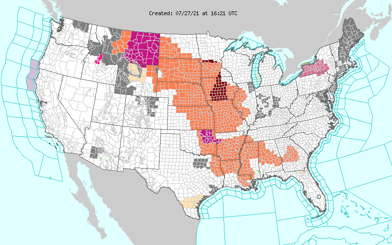
All of those orange and red shades are heat advisories. It is astonishingly hot throughout the Plains and Mississippi Valley. It’s really hard to say there is a cold front when there is a heat wave immediately behind the boundary. The WPC, proponent of the long ranging front, parlays the cold front into a warm front hugging those advisories to the west.
The jet is still somewhat active, but it remains well north of the domestic US. A cooler start to July in the southeast and a blistering start in the north is also starting to level off, but is making for a challenging environment for cold fronts to survive. If a change occurs, it will have to come from the west, which may happen next week.
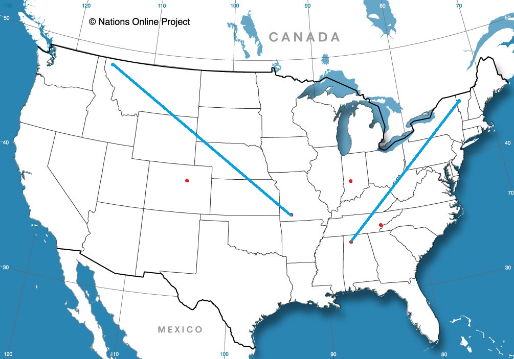
It’s time for another road trip. This route takes us from one state to another that borders another, but we are going to cut through a third to get there. The drive covers about a day and a half, and is 762 miles long. There will be an ample amount of time spent on I-35, which will allow for a pace of 62.9mph. Not as fast as you expected? Well, that’s because of some off – interstate driving through Oklahoma. We’ll work out about 503 miles of driving on Tuesday, with the remainder on Wednesday.
DAY ONE (Wednesday)
Laredo, Texas (via Britannica.comdn
Our day will start from the Mexican border, and take us north through Texas on 35. We will abandon 35 as we head through the Dallas Metroplex and head for the Red River. There is a tail of a weak boundary sagging south through Texas that will trigger an isolated shower or thunderstorm generally north of the Austin area. Nothing severe or long lasting, but just enough to dampen the pavement from time to time. Just before we arrive at the Red River crossing, we will stop for the night in Denison.
DAY TWO (Thursday) As the tail of that boundary drifts further south, it will clear the air in Oklahoma and western Arkansas. Well, not clear it, so much as bottle up the shower and thunderstorm threat to the south of our route. Be prepared, it’s going to be hot and miserable in Fayetteville when we arrive. Find air conditioning.
Arkansas has a surprising number of cities that we can drop forecasts for. The Northwestern Arkansas corridor is definitely more lively than one would normally be lead to believe.
At 953PM, CT, Fayetteville was reporting a temperature of 79 degrees with clear skies and dew points also parked in the upper 70s. It is a surely uncomfortable night which will see some haze across the region by morning. There are heat advisories out across the region, except in the Fayetteville area, where terrain and foliage will help blunt the high temperatures. Low pressure in the Hudson Bay area is the only particularly well organized system in North America, and it is dangling a generally ineffectual boundary through the heart of the country. It is peeling back dew points a bit, and promoting a moist flow through the Lower Mississippi Valley northward, and will continue to do that through the day Sunday. The weak boundary will arrive in town by evening, and may lead to a more comfortable Monday, with isolated thunderstorms a distinct possibility throughout the day on Monday, but also in the evening on Sunday. Tomorrow – Partly cloudy, afternoon thunderstorms. Humid. High 92, Low 73 Monday – Mostly cloudy, scattered showers and storms, High 89, Low 70
TWC: Tomorrow – Scattered thunderstorms in the morning, then partly cloudy late High 92, Low 72 Monday – Partly to mostly cloudy. A stray shower or thunderstorm is possible. High 91, Low 71
AW: Tomorrow – Sun and some clouds with a thunderstorm in spots in the afternoon High 92, Low 73 Monday – Humid with more clouds than sun; an afternoon thunderstorm High 91, Low 72
NWS: Tomorrow – A 30 percent chance of showers and thunderstorms, mainly before 1pm. Partly sunny, High 93, Low 73 Monday – A 40 percent chance of showers and thunderstorms. Partly sunny, High 92, Low 72
WB: Tomorrow – Mostly cloudy with chance of showers and thunderstorms in the morning then partly cloudy with slight chance of showers and thunderstorms in the evening. High 90, Low 75 Monday – Partly cloudy with a 50% chance of showers and thunderstorms, High 89, Low 74
WN: Tomorrow – Partly cloudy with a chance of storms, High 93, Low 72 Monday – Partly cloudy with a chance of storms, High 92, Low 71
FIO: Tomorrow – Humid and partly cloudy throughout the day. High 92, Low 73 Monday – Humid and partly cloudy throughout the day. High 89, Low 72
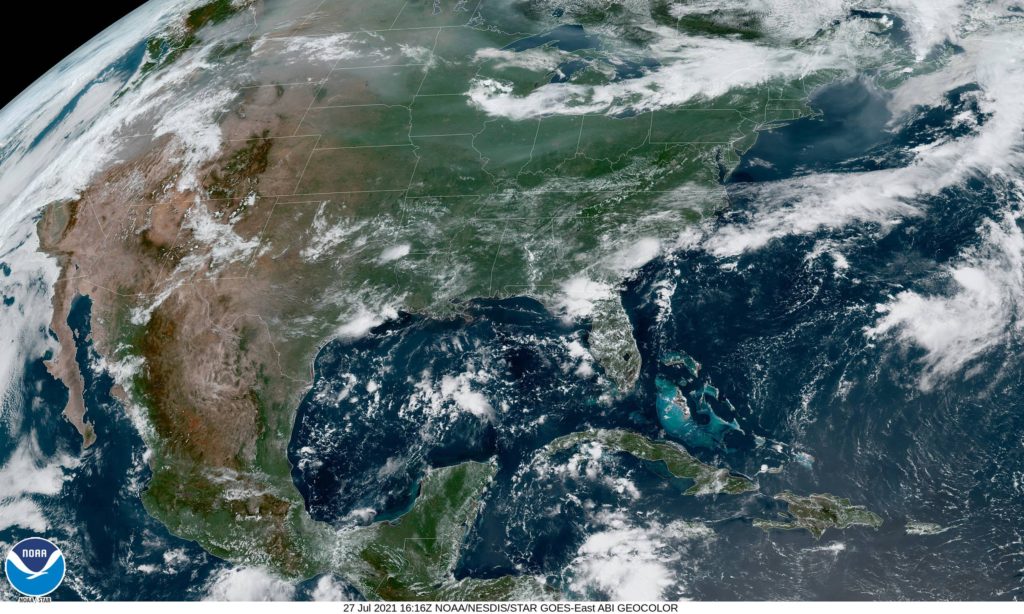
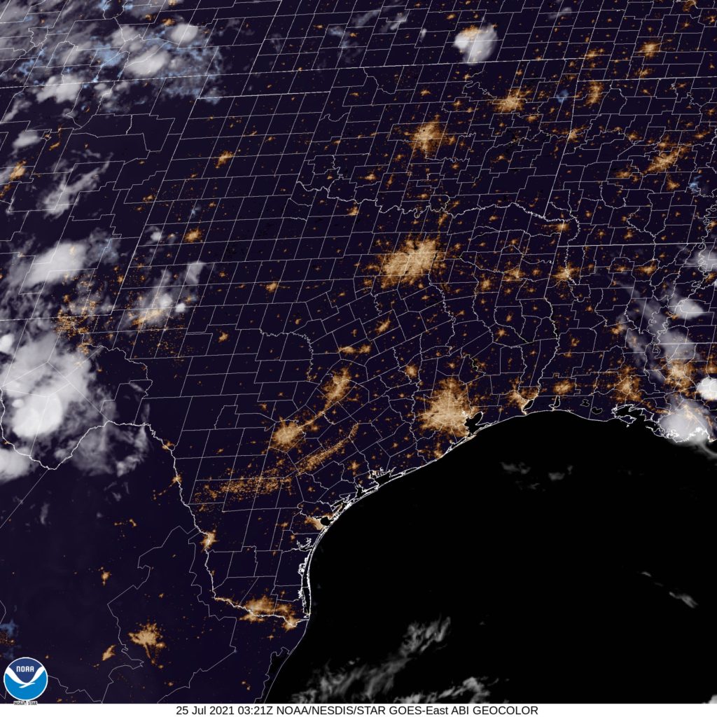
Here is the satellite for the evening, which just shows how clear the skies are to night in the south central US.
We’re heading down to the banks of the Rio Grande for our forecast this evening. Typically this time of the year, we can expect some high heat and a little bit of humidity. Is that the case today as well?
At 656PM, CT, Laredo was reporting a brisk 30mph gust with fair skies and a temperature of 84 degrees. Dew points were near 70, and the moisture rich environment provided an atmosphere that was active with precipitation. A line of thunderstorms ran from north of Victoria to north of Laredo. The storms nearest Laredo on the American side of the border are beginning to diminish, because they are driven less by any synoptic feature, but mostly on the diurnal interaction with onshore flow. A remnant frontal boundary north of the Gulf Coast is leaching some moisture away from south Texas, but is more importantly allowing the space for high pressure to develop over the western Gulf. Scattered showers and thunderstorms will still be possible in Laredo tomorrow, owing less to the onshore flow, and more to the monsoon flowing through Mexico and north towards the dry line and the Front Range. As high pressure builds, it will interrupt the flow of instability into Laredo, and the end of the week projects to be dry, but much warmer. Tomorrow – Isolated thunderstorms, High 97, Low 75 Friday – Sunny and hot, High 102, Low 78
TWC: Variable clouds with scattered thunderstorms. High 94, Low 75 Friday – Some clouds in the morning will give way to mainly sunny skies for the afternoon. High 101, Low 78
AW: Tomorrow – Humid with times of clouds and sun High 93, Low 75 Friday – Breezy and less humid with times of sun and clouds High 99, Low 77
NWS: Tomorrow – A 30 percent chance of showers and thunderstorms, mainly after 1pm. Mostly sunny High 96, Low 77 Friday – Sunny and hot, (early AM rain) High 100, Low 78
WB: Tomorrow – Mostly cloudy in the morning then becoming partly cloudy. A 30 percent chance of showers and thunderstorms, High 93, Low 77 Friday – Partly cloudy in the morning, then becoming sunny,, High 100, Low 78
WN: Tomorrow – Partly cloudy with chance of storms, High 95, Low 77 Friday – Mostly sunny, High 100, Low 78
FIO: Tomorrow – Humid and mostly cloudy throughout the day. High 94, Low 75 Friday – Humid and partly cloudy throughout the day. High 98, Low 77
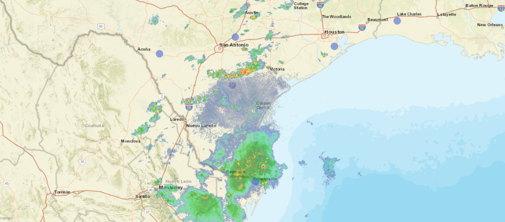
The radar picture below is probably going to be a little less noisy tomorrow, and more so on Friday.
The United States is experiencing it’s own catastrophes this year. Growing wildfires and drought in the west, with flash floods in the southeast, along with heatwaves in the north. A lot of the worst weather in the world seems to afflict the United States in an outsized fashion, but it seems that is not the case in recent weeks.
First is the story of flooding in central Europe. Relentless and heavy rains have been hammering Benelux and western Germany, leading to river flooding on the Rhine in Germany and the Meuse in Belgium in particular, with subsidiaries an other rivers also spilling out of their banks. The intensity of the rains also led to flash flooding in these areas, while the river flooding is continuing to disrupt lives, with the threat of disease adding onto threats to infrastructure and livelihood.
The flooding was the result of a stalled, training pattern of showers and thunderstorms that lasted for the better part of last week. The good news is that the flooding is going to be allowed to abate over the next week, at least. High pressure over the British Isles is going to drift toward the Low Countries and barricade them from additional rainfall for the week. The next real threat for showers and thunderstorms is next weekend, and we can all hope that the feature moves as quickly as the models presently suggest.
A bit closer to home, tornadoes are in the news. The US has had an incredible string of good fortune, in that there were no tornadoes stronger than EF2 in May or June. Unfortunately, in Barrie, Canada, the tornado news was worse. A tornado – measuring at an EF2 – struck residential parts of the community, taking roofs off of houses, but fortunately, doing structural damage and sparing the residents of the houses it hit.
Listen to the tale of Natalie Harris, a City Councilor in Barrie, who saw significant damage to her home during the twister on Thursday.
The greatest damage was to the far southeastern part of town. The damage would surely have been more significant if it had been just a couple miles to the north.
As everyone is likely aware, the western US is embroiled in a drought. The seasonal monsoon is helping in some spots, but at the beginning of the monsoon wasn’t able to bring a whole lot of rain to Prescott, among the many locales that is in a deficit right now. If there was any good news, I guess it was that the heat wasn’t as overbearing as it can be in the southwest. The Weather Service and Weathernation conspired to tie for the top forecast. Actuals: Monday – High 93, Low 66 Tuesday – Rain reported, not measured, High 91, Low 73