Precipitation in California has exceeded all expectations. This is the time of year that the state gets most of its rain, and usually, they can expect a couple of good soakers and impressive snow totals in the Sierras when it happens. The rain doesn’t often fall as intensely in the Central Valley, in addition to the western facing hill sides, as it has this month. Redding, which is at the far northern end of the central California valley system, and called the “sunniest city in California”, was forecast to get some showers during our forecast on the 16th and 17th of December. Instead, it was the beginning of a grueling weeklong stretch of flash flooding and disaster just before Christmas. For our forecast period, Redding saw over an inch and a half of rain, which is quite a bit for anywhere, and certainly a lot for Redding, which has now received twice their monthly expected total for December, already one of the wettest months of the year in northern California. The forecast was fairly well handled on the temperature side, but the quantity of rain was surely underestimated. The Weather Channel had the top forecast. Actuals: December 16th, .96″ of rain, High 48, Low 44 December 17th, .72″ of rain, High 52, Low 43
Let’s head west! Our drive is a little bit longer than the previous one, with this one coverinf three time zones, 4 days and 2,088 miles. We will be able to enjoy the luxuries of highway travel throughout much of the journey, which will afford a pace of 65.25mph, and 522 miles a day. Will we finally see some warm weather?
DAY ONE (Thursday)
Hot Springs, Arkansas
With high pressure beginning to drift out of hte central US, the cold air is alleviating. This, unfrotunately, also means that access to the Gulf is opening again, and some surface moisture is expected to get into the western parts of Arkansas, particularly the valleys, in the morning. This may manifest as a bit of light rain between Hot Springs and the Oklahoma border, but more likely, it will be seen as fog and low clouds. Low pressure is emerging in the northern Plains by tomorrow, and a cold front is going to emerge along our route. No concerns for developing showers or storms, but behind it, there will be a brisk northwest wind. Clear skies are expected after Henryetta, and winds should start to taper off around El Reno. The day will end in Groom, Texas, which is just east of Amarillo.
DAY TWO (Friday) Another wave is going to ripple through the Rockies into the High Plains. What will this mean for us? Not much, save for more blustery winds between Amarillo and Santa Rosa, New Mexico. We will enjoy a bit more tranquil conditions though the high terrain of western New Mexico, and make it to the Painted Desert National Park in Arizona.
DAY THREE (Saturday) The weather is really going ot be churning in the northwestern US, however there isn’t a whole lot to tlk about in the southwest. It won’t be hot in the desert, as we may be accustomed to thinking, which is good news, because our day will end at Edwards Air Force Base.
DAY FOUR (Sunday) It’s probably the best to take highway 99 north through California on a Sunday, right? Or is most of the traffic hanging out on 5? Or does anyone even drive in the Central Valley? Nevertheless, we will be doing it on Sunday, as another system moves into the Pacific Northwest. In the Valley, we will see a smattering of light rain, while the hills and mountains east of us will contend with some significant snow fall, once again. The rain for us will come into the picture around Kingsburg, and in points northward. Sad to say, it may be a bit drizzly in northern California by the time we arrive in Redding on Sunday afternoon.
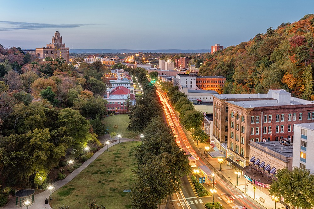
Northern California tonight, to a part of the state that can be just as hot as the southern part of the state, especially inland, like Redding is.
At 753PM, PT, Redding was reporting cloudy skies with a temperature of 46 degrees. There was a little bit of haze at the surface, as there appeared to be throughout the area. Low pressure in the Gulf of Alaska has banded a cold front moving into the west coast, with a few showers seen from Yreka to Eureka. As is often the case, the first attempt at translating through the area will be unsuccessful, however the strong jet will move inland, and low pressure will reconstitute north of Vancouver Island by tomorrow. Rain will move into Redding in the afternoon, which will be heavy at times. Because of the terrain on the coast, the center of low pressure will appear to hop from north of Vancouver Island to the southern part of British Columbia. The phasing of the low is indicative of this system being particularly strong for the west coast. The trough is strong and short waved enough to continue moving eastward into the Prairies. Rain will continue in northern California through Wednesday morning, but will start to clear out through the afternoon. Unfortunately, there will likely be some low clouds and fog leftover as a parting gift, particularly after night fall. Tomorrow – Mostly cloudy with rain becoming heavier in the afternoon, High 50, Low 41 Wednesday – A bit more sun in the afternoon, but rain early, High 56, Low 44
TWC: Tomorrow -Showers early, becoming a steady rain later in the day. High 47, Low 45 Wednesday – Cloudy skies early will become partly cloudy later in the day (early rain). High 52, Low 45
AW: Tomorrow – Cloudy and cool with a little rain High 51, Low 44 Wednesday – A couple of morning showers; otherwise, mostly cloudy High 58, Low 43
NWS: Tomorrow – Showers, mainly after 8am. Widespread dense fog, mainly before 10am High 55, Low 46 Wednesday – Showers. High 58, Low 46
WB: Tomorrow – Cloudy with a chance of rain showers. Widespread fog. . . Locally dense in the morning. High 46, Low 46 Wednesday – Rain showers. High 48, Low 42
WN: Tomorrow – Cloudy with showers, High 55, Low 46 Wednesday – Mostly cloudy with light showers, High 58, Low 46
CLI: Tomorrow – Rain showers, High 53, Low 37 Wednesday – Rain showers, High 52, Low 44
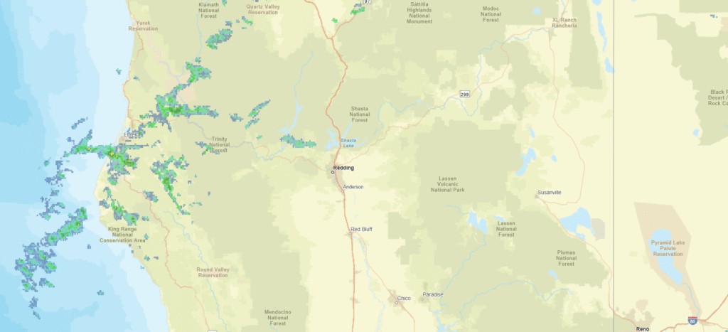
Oh my goodness, this forecast is haunted. I have reviewed the numbers, and there are no typos. Weatherbug has the same high as the low tomorrow. Clime really is 9 degrees colder than the what most others think. The rain timelines are all different. This verification is going to be something else. Here is the radar, with showers northwest of Redding.
There is blistering heat across the planet this week. The United Kingdom is reaching temperatures never seen in recorded history for the British Isles. It reached 115 in Tulsa yesterday. Last week’s 99 and 100 in Redding don’t stand out quite as impressively under that light, do they? Accuweather and WeatherNation had top forecasts for the city, and even those forecasts were a little bit warmer than what actually transpired. *Yawn* Actuals: Wednesday – High 99, Low 71 Thursday – High 100, Low 65
When I think of California, I think of Mt. Shasta or Eureka — Not particularly warm places. Redding is the furthest north major population center in California, and residents there would like to let you know that it can be pretty hot there.
At 853AM, PT, Redding was seeing clear skies, and the temperature of already 85 degrees. Some light flow onshore is bringing fog to the coast. The light, oceanic flow through the Bay Area and the fog on the coast is cooling things of a bit in northern California, though Redding is a clear hot spot, stifled and away from the maritime flow. There is a trough moving through the Pacific Northwest through the middle of the week. Monsoonal flow and cool sea surface temperatures will ensure that there won’t be much moisture associated with the feature, so all eyes will be on the jet trough, with hopes it will break the heat. It doesn’t seem as though that will be terribly successful. If there are any impacts near Redding, it will come in the way of clearer mornings, with fog less likely on Thursday morning. Tomorrow- Hot and partly cloudy, High 101, Low 69 Thursday – Hot and sunny High 103, Low 66
TWC: Tomorrow – Mainly sunny. High 100, Low 69 Thursday – Sunny, High 103, Low 68
AW: Tomorrow – Mostly sunny, High 100, Low 71 Thursday – Mostly sunny and very warm High 102, Low 68
NWS: Tomorrow – Sunny and hot, High 99, Low 71 Thursday – Sunny and hot, High 102, low 70
WB: Tomorrow – Sunny, High 100, Low 73 Thursday – Sunny, High 102, Low 68
WN: Tomorrow – Sunny, High 99, Low 71 Thursday – Sunny, High 101, Low 70
FIO: Tomorrow – Clear throughout the day. High 101, Low 73 Thursday – Clear throughout the day. High 104, Low 69
That’s pretty hot, as promised. And also as promised, it will be cooler tomorrow and Thursday than today, where forecast highs are about 105. Enjoy that relief! Here is the satellite, with low clouds along the coast.
Rain and cooler temperatures moved into the Pacific Northwest this week, and the first bouts of wet weather had just passed Redding by when we stopped in for a forecast. Unfortunately, they never returned, with the jet trough planting itself north of the Oregon border. Redding stayed hot and smoky through the weekend last weekend. The scenario was well anticipated by our forecasters, and there was good clustering across the board, with The Weather Channel securing a solo victory. Actuals: Saturday, High 96, Low 67 Sunday, High 95, Low 61
It’s the weekend, baby! And our drive is going to cover a lot of country at what is really the right time of year to be taking such a journey. Temperatures are usually perfect for keeping the windows down, while you can stop and take in football games on the weekend, or baseball games in the week. This drive will take 5 days, so plenty of chances to stop, and will cover 2782 miles. It’s a hike, but we will break it up into 543 mile chunks at a pace of 67.8mph. Day 5 will be the longest, but it is also the stretch with the fewest roadside attractions.
DAY ONE (Saturday)
Columbia, South Carolina
The eastern US needs to dry itself out, and it will get the chance on Saturday. High pressure is going to build across the southeastern US, at least at the surface. It’s strength will help guide Larry and Mindy northward, while temporarily preventing the development of more tropical activity in the Gulf. It’s not permanent, but it is going to last long enough. Expect now weather related impairment as we head from Columbia to Kuttawa in western Kentucky. It’s kind of a resort-y area, so hotels will be plentiful.
DAY TWO (Sunday) Low pressure is sliding through the Great Lakes toward eastern Canada, and a nearly stationary front will be left in it’s wake. It will try to bubble up some isolated showers and storms along the Minnesota-Iowa border on Sunday afternoon, but the ridge to the south is just going to be too much. Expect instead warmer than normal temperatures along our route, which will end in Dunbar, Nebraska, which is in the southeastern corrner of the state.
DAY THREE (Monday) Driving across Nebraska, at least to me, is fun. It’s really easy to figure out where you are, as the farmland leads to regularly intervals between towns, and you can move pretty quick, especially on a quiet day like Monday. There will be a spot of shower and thunderstorm activity late in the day though, as we approach the Wyoming border. Isolated thunderstorms will pop up in the front range, or until we are over Sherman Summit approximately. We’ll be on the other side of the high range and through Laramie to the Bath exit about 20 miles west of Laramie.
DAY FOUR (Tuesday) Storm activity will pick up in the Plains on Tuesday, so nice work getting out of there when we did. Some late showers and storms will pop up in southern Wyoming, but they should hold until we are into Utah. It looks pretty stormy in the Colorado Rockies too, but that is neither here nor there. In this case, “there” is outside of Wells, Nevada, where we will suspend our journey for the night.
DAY FIVE (Wednesday) Hopefully, the rain that moved through the northwest today helped to quench some of the fires in Northern California and Oregon, but I don’t have high hopes. Temperatures will be dry, and the sky will almost certainly be tinged an unsettling color as we pass through Sierras into northern California and settle into the northernmost Central Valley, to park our butts in Redding.
As is definitely the case across the west, northern California continues to withstand one of the worst droughts the country has seen, perhaps since the Dust Bowl. The fire season has been particularly devastating just to the south of Redding in recent years. With that as a backdrop, lets hope for weather that is favorable to fire fighting efforts.
At 653AM, PT, Redding was reporting clear skies wit smoke and a temperature of 69 degrees. Dew points in the Central Valley were higher than most northern Californians are accustomed to, hanging out in the mid 60s. Isolated showers and thunderstorms are expected this afternoon, thanks to a short waved low rotating through southern Oregon. Unfortunately, it looks backed by more energy than moisture, and as a result, red flag warnings are out for the northern California Sierras, as lightning may touch off more fires. After the energetic bundle shifts out, the exit region of an upper level jet will remain in place along the Oregon/California border. High clouds will dot the skies of northern California, while cool, autumnal conditions will be just out of reach. Flow will be from the west, which will hopefully allow some smoke in the region to clear. Tomorrow – Partly cloudy, High 93, Low 62 Sunday – Mostly sunny, High 96, Low 60
TWC: Tomorrow -A mainly sunny sky. High 92, Low 65 Sunday – Intervals of clouds and sunshine. High 95, Low 62
AW: Tomorrow – Mostly sunny and hot; smoke from area fires will lead to poor air quality High 94, Low 62 Sunday – Sunshine and hot; possible danger of dehydration and heat stroke while doing strenuous activities High 97, Low 60
NWS: Tomorrow – Sunny High 93, Low 65 Sunday – Mostly sunny, High 95, Low 64
WB: Tomorrow – Sunny, High 94, Low 65 Sunday – Mostly sunny, High 97, Low 63
WN: Tomorrow – Mostly sunny, High 92, Low 65 Sunday – Mostly sunny, High 95, Low 64
FIO: Tomorrow- Clear throughout the day. High 95, Low 70 Sunday – Clear throughout the day. High 97, Low 66
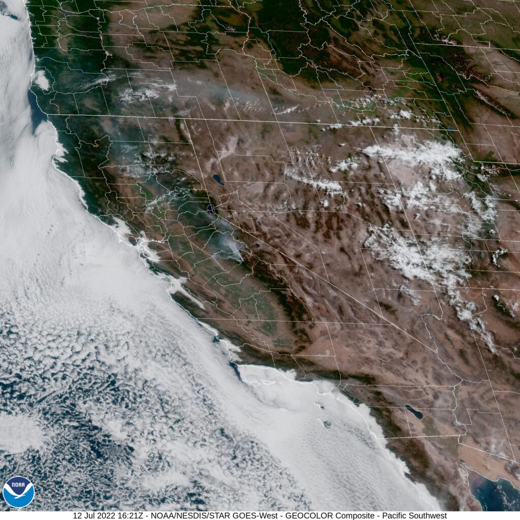
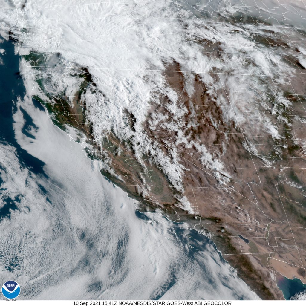
Here is the morning satellite imagery from Redding. It’s pretty cloudy to the north, and it’s tough to pick out individual smoke plumes. The smoke is there though.
Got a long trip from northern CA to the Deep South, covering 2,536 miles, which should take 5 days to cover.
DAY ONE
A broad ridge of high pressure is found over the Great Basin/Four Corners region, which is keeping most of the thunderstorm activity over the Sierras as well as the Rockies in the Four Corners region. Much of the day should be dry and fairly quiet as we travel southward from Redding along I-5 to Sacramento, then along Hwy 99 through much of the Central Valley past Fresno and Bakersfield. Late in the afternoon and evening we’ll cut across the Antelope Valley on 58 before ending our long day in Barstow.
DAY TWO
Going to be spending all day on I-40 as we head east out of Barstow and eventually make our way into northwestern AZ by midday. Some spotty thunderstorms are expected to get going over the mountains as we make our way towards Flagstaff, so by the evening hours some of this activity looks to roll off of them, which could give us a bit of a wet welcome heading past Winslow and Holbrook before ending our night in Gallup, NM.
DAY THREE
Slightly shorter day today, but still a hike across New Mexico as we continue our tour of I-40. However, storms are expected to flare up over the mountains in the central part of the state, so if we don’t get past them in time, we’ll be needing to turn on our wipers as we pass Albuquerque and eventually Santa Rosa. If we can get out ahead of the storms, it should be smooth sailing into Amarillo, TX, where we’ll end the night. Don’t be surprised if some late evening storms roll into town however, might keep us up a bit.
DAY FOUR
Our tour of I-40 comes to an end as we head southeast on 280 out of Amarillo towards Wichita Falls. Unfortunately a boundary settling across the Central Plains eastward is interacting with moisture coming up from the Gulf, and widespread showers and thunderstorms are expected to develop during the midday hours and persist well into the evening. Some thunderstorm activity could get potent as we pass by the Dallas-Fort Worth area, hopefully we’re able to dodge it as we continue onwards and end the long day in Shreveport, LA.
DAY FIVE
Looks like it will be another day of dodging showers and storms as low pressure shifts into the Mid-MS River Valley, increasing the chances of storms from AR/LA eastward into AL/GA as the day progresses. I don’t expect a washout, but you will have to keep an eye on the sky as we push through MS on I-20 past Jackson and eventually into Alabama before finally ending our trip in Montgomery.