If I have to look at this, then so do you.
from Victoria-Weather

If I have to look at this, then so do you.
In some parts of the country, the countdown to sub-freezing temperatures is on. There is already snow in the forecast for higher peaks out west. The clock is ticking for people that are still soaking up the last bits of summer like weather. The brief sojourn through autumn only brings us one place: Winter.
Temperatures are usually all over the place, even if there is a general trend to a season. Even on the warmest winters, I only remember the coldest days, for example. What really separates winters is how much snow you get through the chilly season.
The beginning of 2024 remains to be seen, but to conclude the 2023, CPC’ has the outlook for those final three months. ‘s outlook doesn’t suggest anything too out of the ordinary.
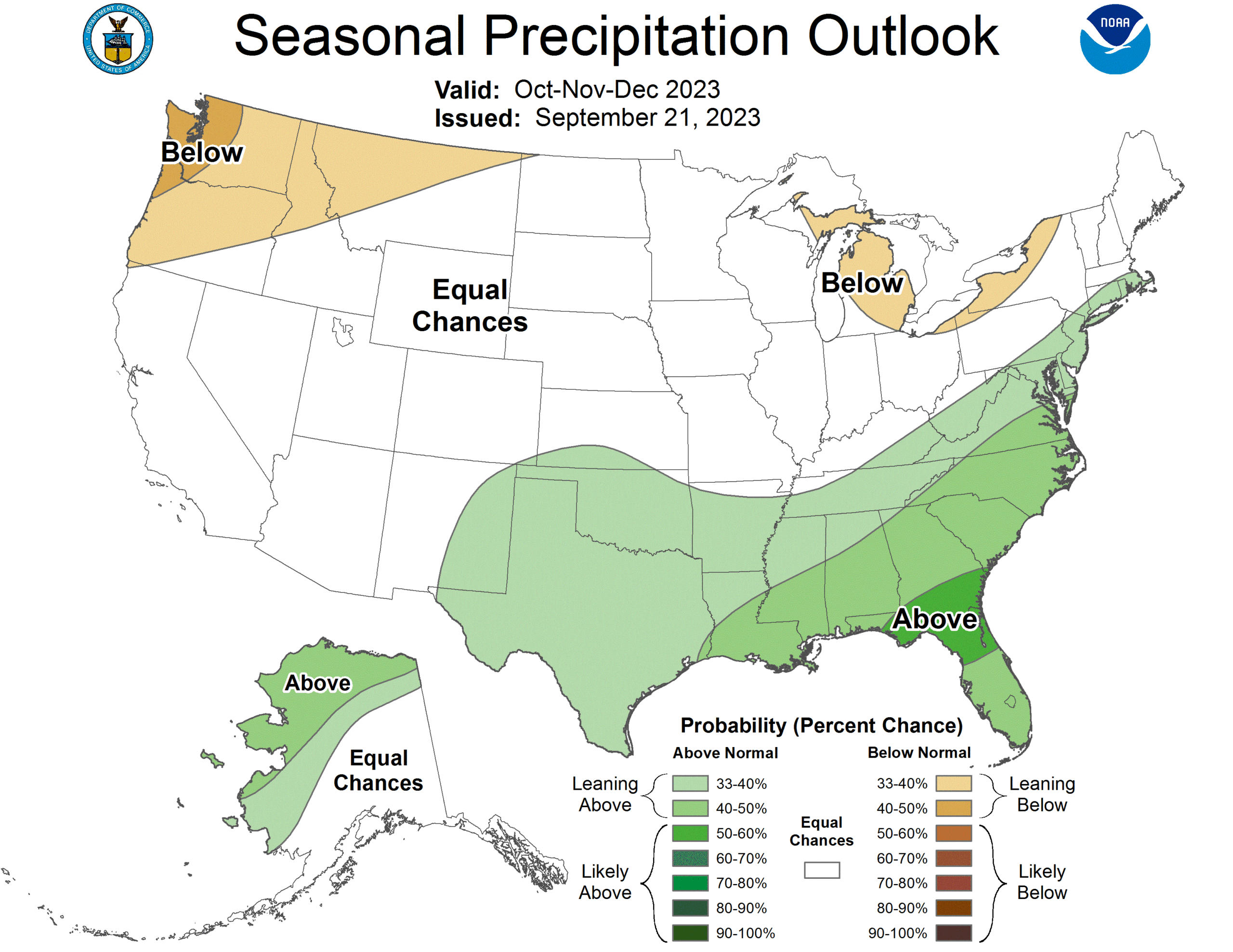
If you were here earlier, you’ll remember that the Gulf Coast was in a drought, and a sloppy fall will help that. Don’t expect a lot of major early season systems, but there will be a few, emerging in the high Plains and headed for the Great Lakes. There will be snow, but not blizzards.
This is, of course, a look at October through December. For those that aren’t ready for summer, at least in the eastern two thirds of the country, the end of September and the beginning of October are going to be notably warmer than normal.
Ophelia was a soaker on the East Coast earlier this week, but right now there are two disturbances in the Atlantic basin, and neither are expected to significantly impact American interests. Tropical Storm Phillippe is going to diminish as he winds into the northern Antilles, and the next area that the NHC is monitoring is expected to spiral into the open ocean, bothering nobody.
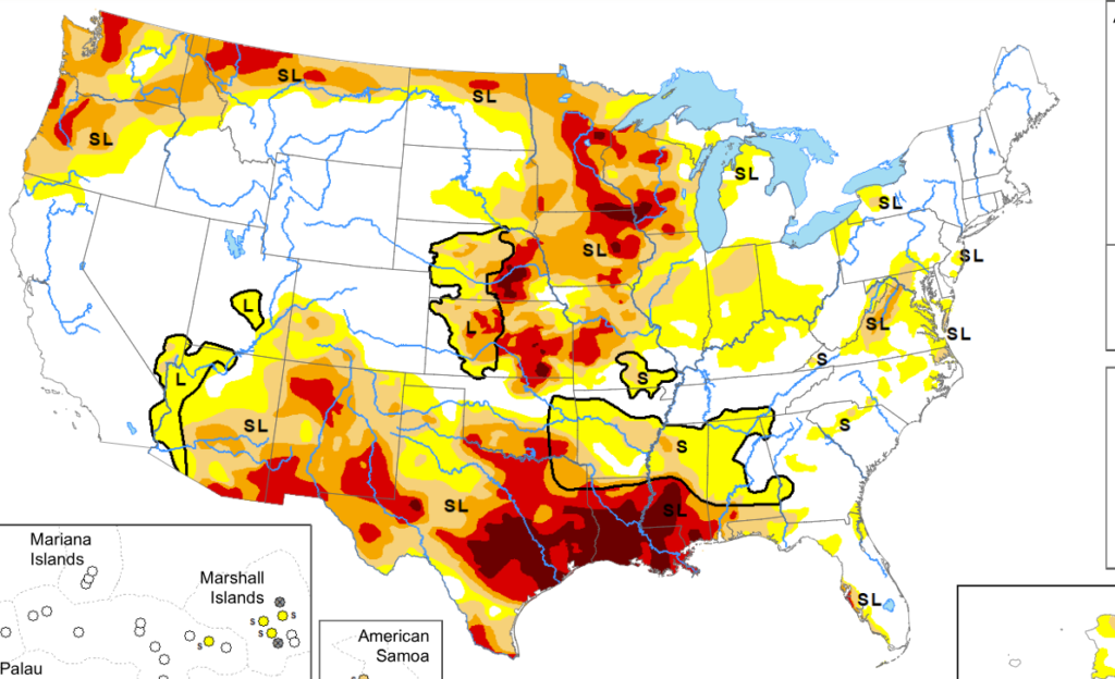
The drought map as summer 2023 winds down is much less aggressive than it has been typically. All the snow, and Tropical Storm Hilary have really taken care of things out west. A soaking rain in the upper Midwest will see some of those areas see their drought levels reduced at the next update. The glaring areas are in two places that typically see a lot of moisture, the Northwest and the western Gulf Coast, so before too long, one would imaging they will see some moisture as well.
Not one but two outlets perfectly nailed the high temperatures on both days of our Lake Havasu City forecast. Clime and The Weather Channel were the two forecasting groups that showed that incredible accuracy, but it was the low temperature forecast that settled this forecast. Clime was better than The Weather Channel, and earned the win.
Actuals: September 14th, High 100, low 72
September 15th, High 102, Low 81
Grade A-C
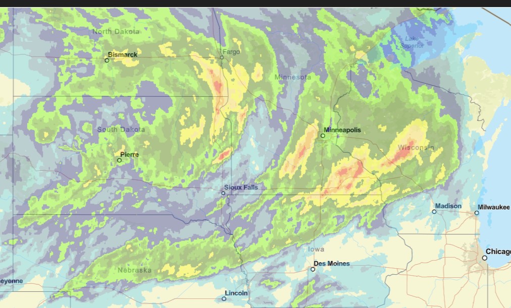
That’s a lot of territory that got a steady rain today. That’s great, but of course it came on the weekend, and at the end of the season. Beggers can’t be choosers.
There will be more to come tomorrow and lastnig to the early part of next week.
It’s going to be a bit of a rainy weekend in Minneapolis-St. Paul this weekend. Hooray! The first batch of rain will arrive late this evening, giving way to a bit of a break tomorrow, followed by the threat for strong thunderstorms (though the heaviest storms will come south of Minnesota) on Saturday, and some lingering rain on Sunday. The area needs to be replenished, but of course, it is all coming on the weekend.
Do you remember all the stories we have heard recently about the western US? I think the most recent weather story was about all the snow and rain the region received first with a vigorous winter and then with the remnants of Tropical Storm Hilary. Now? How about some pleasant, below normal temperatures to wrap up the summer. Weird, huh?
Man, it just seems like the Twin Cities can’t get a drop of rain these past couple of years
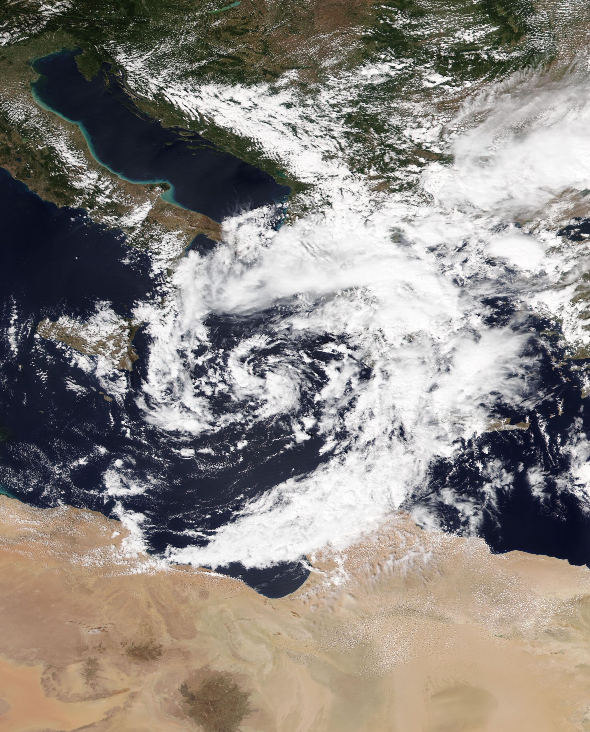
The above is satellite imagery from about 2 weeks ago, as a spiral band from Storm Daniel lashed the Libyan coast east of the Gulf of Sirte. Derna is one of the most northern points of that part of Libya, and suffered the most severe consequences of what was a virulent storm.
Daniel developed in the central Mediterranean, and started making headlines by bringing flooding rains to Greece, where Larissa, in particular, found itself underwater. This was caused by an Omega block, ridges of high pressure that orient the jet in the shape of the Greek letter Omega. This is a generally immobile pattern, and can cause short term drought beneath the ridge, and persistent rain on either side. Daniel wasn’t moving much, wobbling between the southern Balkan Peninsula and northern Libya.
The second accelerating factor was terrain of Libya in general, and the area near Derna, specifically. As you may know, Libya is dominated by the Sahara Desert. There is the Mediterranean climate in the northern coastal areas, so Derna and the other large cities of northern Libya aren’t foreign to rain, but it is pretty dry there, and significantly drier further to the south. It’s not soil that is receptive to rain falling at persistent or voluminous rates. It is prone to running off.

Pictured above is the 3d view looking north from Derna on Google Maps. There is a small river emerging from a network of canyons that cut deep into some cliffs. The entire topography of the region is set up to funnel runoff out of the desert through this canyon and out of Derna. There is a dam at the mouth of the canyon which allowed Derna to exist while also generating some electricity.
There WAS a dam, I should say. Under the onslaught of a cyclone’s worth of rain funneled through the canyon, the poorly maintained dam failed, unleashing all this water on Derna. Undoubtedly, years of dictatorial rule followed by a decade of civil unrest had led to poor civil infrastructure maintenance, and ultimately, tragedy.
As is often the case with the worst disasters, there was a perfect confluence of circumstances that made it so horrific.