Victoria, Texas

This seems to always be a little confusing. I’m putting together a forecast for Victoria, Texas, and I’m happy to do so, but this site is named after my home town, which is in Minnesota, and we forecast for a lot of places, everywhere in the country, and not just Victorias. OK? All right, let’s forecast.

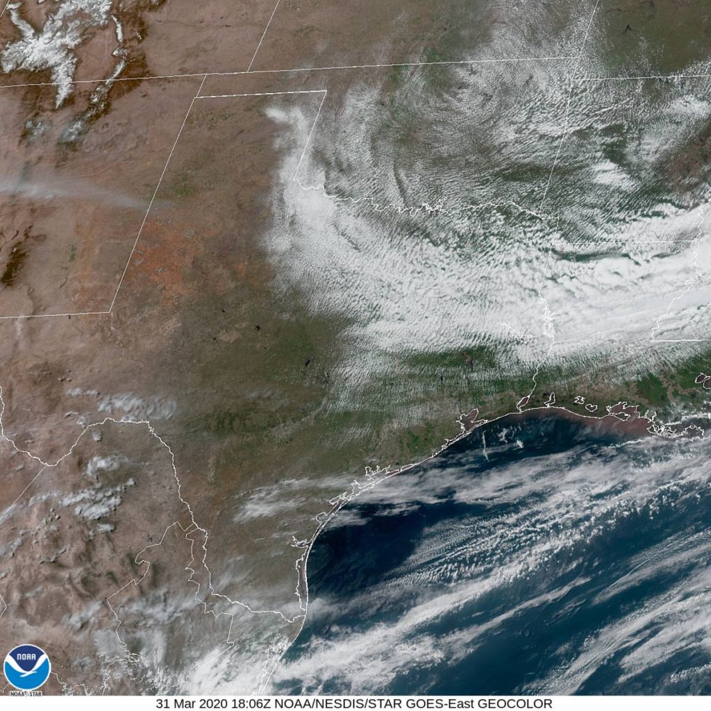
At 1151AM, CT, Victoria was reporting a temperature of 74 degrees with clear skies. A cold front lay off shore, extended from a line of severe thunderstorms in Mississippi and Alabama, and brisk north winds blew through the Gulf Coast. Upper level troughs were trailing meekly behind, bringing some bands of clouds to the Red River Valley, though Victoria looked good.
A shallow ridge will bring about pleasant and quiet weather tomorrow. A trough racing out of the Rockies will be undercut by an increasingly laminar jet over the southern US. While the through will parent a decent pressure fall, it will be robbed of moisture by the flow to the south. There should be just enough moisture entrainment across the Gulf, however, to lead to low clouds and fog in Victoria on Thursday.
Tomorrow – Mostly sunny, High 77, Low 52
Thursday – Overcast with fog at times, High 79, Low 60

TWC: Tomorrow – Sunshine and clouds mixed. High 79, Low 55
Thursday – Variable clouds with thunderstorms, especially in the afternoon High 80, Low 64

AW: Tomorrow – Mostly sunny High 79, Low 54
Thursday – Cloudy with a shower or thunderstorm in the area High 77, Low 63

NWS: Tomorrow – Mostly sunny, High 77, Low 53
Thursday – A 30 percent chance of showers. Mostly cloudy, High 80, Low 63

WB: Tomorrow – Partly cloudy, High 77, Low 56
Thursday – Mostly cloudy with a 30% chance of showers. High 78, Low 64

WN: Tomorrow – Partly cloudy, High 77, Low 53
Thursday – Mostly cloudy with scattered showers, High 80, Low 63

FIO: Tomorrow – Partly cloudy throughout the day. High 76, Low 50
Thursday – Mostly cloudy throughout the day. High 76, Low 60

I think these qualify as good days on the Gulf Coast. It’s not too chilly for locals, and it’s not too hot for guests. Check out he local satellite imagery, with a band of clouds that isn’t nearly as threatening as it appears.

Anderson, Indiana

Indiana was among the states in the firing line for strong thunderstorms last night. There were a few spots of severe weather damage, but mostly, it was a wake up call for the beginning of the severe season.

At 153ET, Anderson was seeing a temperature of 55 degrees with overcast skies. A large area of low pressure moving through the Great Lakes, and is now heavily occluded after bringing some widespread severe weather to the Mississippi and Ohio Valleys last night. The southern edge of the shield of clouds over the center of circulation stretched over central Indiana, leading to the overcast in the region, and depressing temperatures in northern Indiana.
The jet is mostly laminar, which means there will be a slow transition from feature to feature. Don’t be surprised if it takes a while for the clouds to fully pull out of town. Fortunately, the slow pace of translation of surface features also means that the next round of wet weather will take it’s time reaching town as well, and Tuesday should provide for a calm, mostly cloudy day, though more cool air will filter in.
Tomorrow – Cloudy, High 53, Low 40
Tuesday – A little more sun, but cooler, High 46, Low 34

TWC: Tomorrow – A mix of clouds and sun in the morning followed by cloudy skies during the afternoon. High 47, Low 39
Tuesday – Cloudy skies High 42, Low 32

AW: Tomorrow – Breezy in the morning; otherwise, periods of clouds and sun High 49, Low 40
Tuesday – Mostly cloudy and chilly High 43, Low 32

NWS: Tomorrow – Partly sunny, High 50, Low 41
Tuesday – Mostly cloudy High 45, Low 34

WB: Tomorrow – Mostly cloudy until midday then becoming partly cloudy, High 46, Low 38
Tuesday – Mostly cloudy, a 20% chance of rain showers in the afternoon High 40, Low 35

WN: Tomorrow – Partly cloudy, High 50. Low 43
Tuesday – Mostly cloudy, High 45, Low 34

FIO: Tomorrow – Partly cloudy throughout the day. High 51, Low 40
Tuesday – Overcast throughout the day. High 47, Low 31

Weatherbug with what can only be described as a rogue forecast on Tuesday. Looking pretty similar across the board otherwise. The low on Monday may be low standard when all is said and done. Here is satellite, showing a big disc of clouds.

Daylong drizzle

This has been a tough time in American history, and in Bremerton, Washington, on Tuesday and Wednesday, the weather decided to mimic the mood. It was cloudy and drizzly across Puget Sound through the middle of the week, exactly the solemn and somber atmosphere this era needs. The Weather Channel and Weatherbug ended up sharing honors.
Actuals: Tuesday – .31 inches of rain, High 45, Low 37
Wednesday – .15 inches of rain, High 49, Low 32

Grade: B – C

Coronavirus and the severe weather season

I don’t need to tell you that the the novel coronavirus, causing Covid-19, has put the nation at a standstill. One of the few rays of light from this strange state of affairs is the respect shown to the doctors and epidemiologists who are offering advice and instructions. As a meteorologist, I am envious of these scientists who have grabbed the attention of the public and the powers that be, and have incited action in the face of grave danger.

Granted, there are many people who reject the threat of the disease out of hand, as many are also quick to dismiss a severe weather warning, and it is for a similar reason. While the disease is much more lethal than the flu, the threat it will cause severe symptoms in any particular individual is almost astronomically small. The highest rate of infection in the world right now is in San Marino, a tiny principality embedded within Italy, and even there, the fraction of the population that has been confirmed as having the virus is less than 1%. Similarly, among those who contract the virus are said to have a death rate of 4%. These numbers are all very small.

The problem is that those numbers are all coming at the same time, especially if nothing is done about it. Having 4% of 1% of the population dying of this would still account for 120,000 people passing away after 3,000,000 people get sick. Those numbers would paralyze the medical system across the country. The threat to any one individual is small, but the threat to the system is very large.

Consider the television meteorologist, who gets hate mail for interrupting programming to provide alerts when there is a dangerous situation in a particular viewing area. Just think of Nashville earlier this year, where a tornado tracked through the metropolitan area, killing dozens and injuring hundreds. Still, if you lived in Oak Hill, you were unaffected by the worst of the storms. There was no threat to you, but the Nashville system was heavily disrupted, and the TV Meteorologist had to warn for the whole system, even if it was simply an inconvenience in the south metro (and the far north metro, for that matter).

Now, that same TV Meteorologist might have to tackle the next severe outbreak, or even the next month’s worth of outbreaks, from their home office, rather than surrounded by colleagues and advanced monitoring equipment, as we all try to stay away from others to prevent the further spread of Covid-19. Of course, more people will be at home, hopefully paying attention to the television or radio when severe weather looms.

Of course, when a tornado or severe weather event strikes, it can lead to a mass trauma event. Many people need medical attention all at the same time. This pandemic is an ongoing, ever worsening mass trauma event as well. With the spring and severe weather coming, can any part of the country stand to bear another compounding disaster?

I fear we will find out this spring, and I am more fearful that we won’t like the answe,

Bremerton, Washington to Richmond, Virginia

Granted, the world is in flux, and long distance road trips are frowned upon at this moment in time, but the shipping needs of the country ensure that there will be people covering this kind of ground. Even without that necessity, seeing daily cross sections of the weather has its benefits. This drive will cover 5 1/2 days of mostly empty freeway, covering 2917 miles. That means our pace will be 66.3mph, which means Chicago is really going to slow us down. The days will be consumed by 530 miles of travel. Buckle up and here we go. 

DAY ONE (Wednesday)

Bremerton, Washington

Its a gloomy day down in the Puget Sound, and it’s not going to change through tomorrow morning. The deteriorating feature that is bringing the gloom to Bremerton is going to squeeze a few flakes into the Cascadian peaks, with additional activity over northern Idaho that will dissipate into the early afternoon. The mountain tops may be obscured as we reach Montana and pass through Missoula to Clinton, but at the surface it should be dry.

DAY TWO (Friday)
We will emerge from the high country of the Rockies into the vast emptiness of Big Sky country. Sure, we’ll pass through Billings and Butte and Bozeman and a few cities that don’t begin with a B, but otherwise we will be firmly in no mans land. We are east of the Rockies, so downslope flow should give an artificial bump to the temperature early in the day, but a developing feature over te central Rockies will bring temperatures back down again. Not much for clouds, and probably nothing for precipitation on the day, which will end at exit 192, where there is a rest stop and a historical marker, but no easily accessed inhabited areas. Social distancing!

DAY THREE (Saturday)
The rest of the drive in Montana, as well as that in North Dakota will not be terribly challenging, though east of Jamestown, we might notice increasingly blustery conditions. This is owing to that big area of low pressure that we talked about in the central Rockies. It looks like it will deepen quickly and bring Minnesota and the Upper Midwest an interesting weekend. Starting not long before we wrap up the day, there might be a few flakes, and coupled with the increasing wind, it will certainly compel us to pull off the road near Ashby, Minnesota.

DAY FOUR (Sunday)
I think a heavy stripe of snow is possible between Fergus Falls and St. Cloud, Minnesota overnight, with the rest of the region blasted by wind and rain. The entire system is going to shift away from the western Great Lakes by the afternoon on Sunday, so our challenge will be driving along that first hour or so, hoping the warm spring means no snow sticks to I-94. The pavement will be wet through the Twin Cities, but should have had plenty of time to dry before we hit Wisconsin. The day will end in Poynette, north of Madison.

DAY FIVE (Monday)
The 5th day of our trip will be clearer and more well populated than the first stretch. We’ll pass Chicago, Indianapolis and Dayton on our way to Frankfort, Ohio, all under the protection of a ridge of high pressure. IT’s not going to be a warm ridge, necessarily, but it will be dry.

DAY SIX (Tuesday)
Yet another round of low pressure is developing to our south and will be shifting to the northeast during the day, intercepting our route over West Virginia. Driving Charleston can be a bit challenging, because there are no straight lines and it’s hilly, so be careful and keep both hands on the wheel. The rain will tail off for a bit as we descend into Lexington, Virginia, and will remain in our rear view as we approach Richmond. Don’t worry, though, the rain will show up later.

Richmond, Virginia

Bremerton, Washington

The world seems to be hunkered down thanks to the insidious Coronavirus. One of the first hot spots was the Seattle area, but in Washington State, at least, the spread has been predominantly confined to the Seattle area. Bremerton, which is just across Puget Sound from Seattle, and Kilsap County have only reported 20 positive tests, opposed to the hundreds across the Sound. With all this going on, meteorologists still need to be aware of the weather, and share that information with you. So lets get to it then, shall we?

At 1019AM, PT, Bremerton was reporting a temperature of 45 degrees with mostly cloudy skies. An already landed area of low pressure is moving southeast from British Columbia, bringing the overcast from Georgia Strait into Puget Sound, while also introducing some snow to the Cascades and Olympic Mountains. The surface low will deteriorate as it presses further into Washington, and the sharp angled upper trough will deepen to the southwest, ensuring cooler conditions and more overcast, at least through the day tomorrow.
The jet over the center of the country will strengthen and lead t development well to the east of Washington State, but the trough aloft will encourage the sinking air aloft, and the Puget Sound will remain socked in with low clouds, fog and some light drizzle through Wednesday.
Tomorrow – Some light rain, otherwise overcast, High 50, Low 36
Wednesday – Overcast with some fog and a bit of light rain, High 50, Low 33

TWC: Tomorrow – Cloudy with occasional rain showers.High 48, Low 36
Wednesday – Mostly cloudy in the morning then periods of showers later in the day. High 50, Low 33

AW: Tomorrow – Cloudy and cool with a couple of showers High 50, Low 37
Wednesday – More clouds than sun with a shower in places in the afternoon High 51, Low 34

NWS: Tomorrow – Showers likely, then showers and possibly a thunderstorm after noon. High 48, Low 39
Wednesday –   A 40 percent chance of showers, mainly after noon. Partly sunny, High 51, Low 37

WB: Tomorrow – Rain showers likely in the morning, then rain showers and a slight chance of thunderstorms in the afternoon. Rainfall amounts a tenth to a quarter of an inch possible, except higher amounts possible in thunderstorms, High 47, Low 36
Wednesday – Partly sunny. Patchy fog in the morning. A slight chance of rain showers in the morning then a chance of rain showers in the afternoon, High 48, Low 34

WN: Tomorrow – Mostly cloudy with light showers, High 48, Low 39
Wednesday – Partly cloudy with scattered showers, High 51, Low 37

FIO: Tomorrow – Possible light rain throughout the day. High 48, Low 35
Wednesday – Partly cloudy throughout the day. High 48, Low 33

A look at the radar shows some showers scooting north of the Olympic Peninsula, but louder returns in the Cascades. Another lovely day for the Puget Sound.

Feature Forecaster: Kelly Greene

Before the entire planet went bananas, I had reached out to Kelly Greene, a meteorologist at WTHR in Indianapolis about putting together a feature forecast for Columbus, Indiana. She agreed to do so, but was about to take a vacation. and then came back, and despite everything, remembered our conversation. Truly impressive during these incredible times. It’s quite flattering! That’s enough out of me, the rest is all from Kelly.

A strong storm system moved over south central Indiana late day Thursday and Friday.  Heavy rain in excess of 2″ to 3″ fell, with Columbus receiving close to 2″ of rain.  Rivers will rise this weekend, including the Flatrock River and the East Fork White River in Columbus.  Only minor flooding is expected.  
A cold front will bring in much colder air for the weekend, making it feel more like winter instead of the first weekend of spring!  Temperatures will fall behind the front, eventually bottoming out into the upper 20s Saturday morning.  Skies will be partly sunny by Saturday afternoon and the winds will relax.  Afternoon highs will only climb into the low 40s Saturday afternoon, running more than 10 degrees below average.  
Sunday will be a bit warmer with increasing clouds.  Temperatures will start off near 30° in the morning and will rebound into the mid 40s by afternoon.  The next system arrives by mid afternoon, bringing more scattered showers Sunday afternoon into Monday morning.
Spring-like temperatures return for the rest of the week.


Kelly Greene is a meteorologist at WTHR in Indianapolis and lives in Fishers, Indiana with her husband.  Kelly actually lived in Columbus many years ago, and experienced many floods during that time.  Kelly enjoys golf and travel and looks forward to being able to play 18 holes again soon.  

Kelly can be found on social media at the following addresses

Facebook: @kellygreeneweather
Instagram: @Kellygreenewthr
Twitter: @kellygreenewthr

Lebanon, Pennsylvania

Well, this has certainly been an interesting week. The weather continues apace, regardless of the virus that is gripping society. Let’s check out southeastern PA.

At 856PM, ET, Lebanon was reporting a temperature of 47 degrees with overcast skies. There was overcast across the region with light return showing up on radar across central Pennsylvania, though there weren’t any precipitation reports from reporting stations east of Pittsburgh.
The band of precipitation is the tail front attached to low pressure moving through Hudson Bay. A shallow jet trough covers northeastern Canada, and is sort of the second step of a two step jet stream. Ultimately, there is a ridge over the eastern part of the country, which is helping to mitigate the threat of precipitation, but will also allow some clearing tomorrow afternoon. The lower step of the jet is going to continue to translate eastward and with it, the next round of wet weather. A warm front, laden with fairly heavy rain and potentially an isolated thunderstorm will arrive late in the evening on Wednesday.
Tomorrow – A little bit of early rain, High 55, Low 43
Wednesday – Mostly sunny with increasing clouds and a late shower or thunderstorm, High 55, Low 35

TWC: Tomorrow – Rain showers early with overcast skies later in the day. High 57, Low 38
Wednesday – Partly cloudy skies in the morning will give way to cloudy skies during the afternoon (late rain). High 57, Low 32

AW: Tomorrow – A passing shower or two in the morning; otherwise, clouds giving way to some sun High 57, Low 31
Wednesday – Increasing clouds (late rain) High 57, Low 31

NWS: Tomorrow – A chance of light rain, mainly before 10am. Cloudy High 57, Low 3-
Wednesday – Sunny (late rain), High 56, Low 33

WB: Tomorrow – Cloudy, a chance of light rain in the morning, High 57, Low 40
Wednesday – Sunny (Late rain), High 56, Low 35

WN: Tomorrow – Mostly cloudy with scattered showers, High 57, Low 40
Wednesday – Mostly sunny, High 56, Low 33

FIO: Tomorrow – Possible drizzle in the morning. High 57, Low 38
Wednesday – Partly cloudy throughout the day. High 58, Low 31

It looks like we are visiting Lebanon right between two bouts of rain. What timing! Maybe things are looking up.

The desert damp

For most of us, a hundredth of an inch of rain is pretty inconsequential. In a place like Tucson, though, it is out of the ordinary, and forecasters should definitely attempt to account for any threat of it. Mea culpa. Last week, on the 8th, a hundredth of an inch did indeed fall on the city, which almost everyone handled correctly. It was a pretty snug forecast otherwise, a trend we have definitely been experiencing this year, and The Weather Channel ended up edging the competition.
Actuals: Sunday, March 8th, .01 inches of rain, High 66, Low 51
Monday – High 75, Low 44

Grade: B-C