The Nashville tornado – The worst of all things

Last week, a devastating set of tornadoes swept through north central Tennessee, claiming the lives of 24 people and injuring hundreds, while causing significant damage across the region.

Frankly, you couldn’t ave asked for a worse set of circumstances for these storms. While we can’t underestimate the the amount of suffering that the storms caused, we also can also state that it could have been significantly worse, and the margin was very close. Let’s look at the circumstances in question.

  1. Time of Day: The first tornado from this outbreak dropped shortly after 11pm, with the Cookeville tornado occurring just before 2AM. Given that this outbreak occurred after most people were in bed, the effectiveness of warnings was reduced even further than normal, and few people in the path of the storm likely prepared as would have been prudent
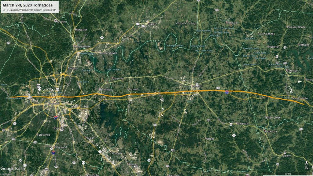
  2. Location: These tornadoes went through heavily populated locations. The longest track any of these twisters took was an incredible 60 miles, and it started west of Nashville before crossing an airport and eventually through the city center, The storm passed between the Grand Ole Opry and Downtown, south of the Hermitage and across commercial and residential districts. A venue that hosted a political rally that very night was leveled. To summarize, there were definitely people in the path of this storm.
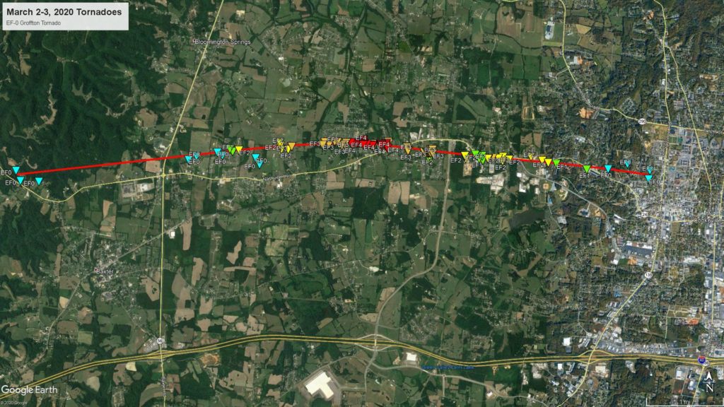
  3. Strength: That storm that went through the city center of Nashville did so as an EF2 to EF3 storm, and remained an EF3 as it did considerable harm to life and property in Mount Juliet. The Cookeville tornado, which skirted the city limits was stronger, grading as an EF4, and was the deadliest as a result.

Take a look at the storm tracks of the Nashville and Cookeville tornadoes below to reference what I discussed above.

Nashville Tornado Track
Cookeville Tornado Track

That is a recipe for disaster, and one that likely left most residents feeling helpless. The storms themselves were moving at 80mph as well, which would have limited warning times even if they had come during daylight. The storms had a mission, and Tennessee is proving how strong the state is, thanks to the ability to withstand such as storm, and their immediate attempts at recovery.

February Forecaster of the month

February wasn’t nearly the snowlogged marathon that it was in 2019, even though we had an extra day in the month. Also, February wasn’t quite as tightly clustered among the forecasters as January was. This milder, tamer month led to only one winner for the month, and one that didn’t do as well in January. Congratualtions to the Weather Channel, our top performer in our second month.

OutletMonth wins
The Weather Channel2
WeatherNation1.33
Weatherbug0.33
Forecast.io0.33
Victoria-Weather
National Weather Service
Accuweather
OutletMonth winsyear wins
Victoria-Weather3.5
WeatherNation1.332.83
Weatherbug0.332.33
The Weather Channel22
National Weather Service1
Forecast.io0.330.33
Accuweather

Rain from the desert

Early last week, an area of low pressure developed in the 4 Corners and shifted into Texas, chasing the system that eventually led to the devastating tornadoes in Tennessee. The chasing system was a rainmaker, though, bringing more than an inch of rain to Killeen on Wednesday, which was probably unwelcome, but at least it was well predicted by a series of good forecasts. The best belonged to none other than Victoria-Weather, who are undefeated now in March.
Actuals: Tuesday – Trace of precipitation High 72, Low 62
Wednesday – 1.23 inches of rain, High 64, Low 49

Grade: A-C

Greensboro, North Carolina to Tucson, Arizona

After a trip to Greensboro, let’s take a lengthy trip from Greensboro. It’s going to take us 3 1/2 days to location to location, and it will require a pace of 71.2mph to cover our 2065 miles, which is downright blistering. We’ll cover 569.7 miles on those first three days, leaving a little bit left over for the fourth day. Westward ho.

DAY ONE (Sunday)

Greensboro, North Carolina

I am quite taken with the rapid pace we will take as we get started off towards Tucson. We’ll alight through 4 different states as we begin, both Carolinas, Georgia and Alabama, where we will finish things off. High pressure is stout in the southeast, and we won’t have any weather concerns between Greensboro and Boligee, Alabama, where we are going to stop for the night.

DAY TWO (Monday)
Low pressure is emerging from the southern Rockies this weekend, and will be a rainy little system moving through the Plains. The tail of the cold front will dangle into the Lower Mississippi Valley as we also scoot through that same part of the country. Shower activity will be possible from about Ruston, Louisiana west into the Piney Woods of Texas. It should be cloudy but dry west of about the Tyler area, which will take us into the Metroplex by evening. The day will end in Fort Worth.

DAY THREE (Tuesday)
Leaving Fort Worth on Tuesday, we will enter the vast expanse of west Texas. It will be at it’s warm, dry and dusty best. There will be no well organized system across the region, but west Texas will indeed be squeezed between features, which will render the region cloudier than normal, but not quite rainy. We’ll make it as far as Tornillo, which isn’t quite to El Paso. Texas is very big.

DAY FOUR (Wednesday)
The next round of wet weather for the desert Southwest, and there certainly aren’t many, usually, will be running into the area on Wednesday morning. There won’t be much rain east of Las Cruces, but there will be a few showers with some elevation wet snow for the entirety of our drive on Wednesday. When you go to Tucson, you probably don’t expect rain, but alas, that’s what we are going to find on this occasion.

Tucson, Arizona

Tucson, Arizona

Let’s see what’s going on down in Arizona tonight. Anything? Anything at all?

At 853PM, PT, Tucson was reporting a temperature of 68 degrees with clear skies. The western US is much more active than usual, with a broad, strong trough angled into the west coast. The exit arm of the trough extends just to the southeast of Tucson, and some mid to high clouds shouldn’t be ruled out tomorrow.
Low pressure will consolidate on the Colorado/New Mexico border through the day tomorrow, with precipitation becoming more widespread in southern New Mexico and the terrain east of Tucson. This feature will shift into the Plains, but the southwest will broadly be within a trough. Low pressure will develop over the Pacific west of the Baja, and the skies over Tucson will be a little bit more congested than usual to start the week.
Tomorrow – Mostly cloudy, High 69, Low 52
Monday – Mostly cloudy, High 74, Low 50

TWC: Tomorrow – Mostly cloudy skies with a few showers after midnight. High 67, Low 55
Monday – Except for a few afternoon clouds, mainly sunny. High 75, Low 48

AW: Tomorrow – A shower or thunderstorm in the area in the morning; otherwise, rather cloudy and cooler High 68, Low 55
Monday – Partly sunny and warmer High 76, Low 47

NWS: Tomorrow – Scattered showers, mainly before 11am. Partly sunny, High 71, Low 54
Monday – Sunny, High 77, Low 45

WB: Tomorrow – Mostly cloudy with scattered showers in the morning then partly cloudy with isolated showers in the afternoon, High 66, Low 59
Monday – Mostly sunny, High 73, Low 49

WN: Tomorrow – Partly cloudy with scattered showers, High 71, Low 54
Monday – Mostly sunny, High 77, Low 45

FIO: Tomorrow – Possible drizzle in the morning. High 71, Low 46
Monday – Overcast throughout the day. High 74, Low 60

I sure could end up with egg on my face if (and probably when, knowing my luck) it rains in Tucson on Sunday. Check out the satellite, with heavier clouds just to the southeast of town.

False returns

To start the month of March, we were monitoring the forecast in Hattiesburg, Mississippi. There wasn’t much to it, honestly, with high pressure over the region and — wait, light rain overnight? I call shenanigans. Actually, specifically, I call out the tendency for the ASOS in the Hattiesburg office for suggesting mist when there often isn’t any. It tends to fog in pretty severely in Hattiesburg, but the actual condensate is harder to verify as legitimate precipitation.
I digress. Nobody had , true or not, in the forecast, so we can comfortably say that Victoria-Weather collected the victory.
Actuals: Saturday – High 71, Low 31
Sunday – High 71, Low 39

Grade: B-C

Killeen, Texas to Greensboro, North Carolina

The southern US has been trounced by severe weather lately, from the devastating tornadoes in Nashville and Cookeville, Tennessee, to persistent thunderstorms nearer the Gulf Coast. There is a break in the action, finally, across the region but will it last for our 2 day, 1219 mile route. Will these storms return, or will we be able to manage a steady pace (estimated at 66mph, with a goal of 529 miles in day one)?

DAY ONE (Saturday)

Killeen, TX

A split jet stream over the eastern US is coming together off shore in the Gulf Stream, meaning any and all concerning weather is going to be off shore this weekend. The primary concern between Killeen and Brandon, Mississippi, our destination for the night, will be ensuring that we remember our sunglasses and sunscreen in case we want to sit outside for dinner east of Jackson.

DAY TWO (Sunday)
Brandon, Mississippi, is the home of the WFO for Jackson, and in my opinion is one of the best offices in the country. Too bad the weather is going to be so pleasant while we’re there. High pressure will only consolidate over the southeast, and the drive from Brandon to Greensboro will continue to be pleasant, though in the wake of the strong system now off shore, it might be a little cooler in Greensboro than anywhere else along our drive.

Greensboro, North Carolina

Coming soon…

And away we go, spring is on the horizon and maybe we can start to see fewer snow storms in our forecasts. Multiple cross country road trips beg of that, while there will be only a couple of western forecasts which should remain snow free.

Tucson, Arizona
Road trip from Greensboro, North Carolina to Tucson

Road Trip from Lebanon, Pennsylvania to Madison, Wisconsin

Bremerton, Washington

Road Trip from Bremerton to Richmond, Virginia

Killeen, Texas

We’re just following election states around, I guess. Well, this time, we are off to Texas, which votes tomorrow as part of Super Tuesday. I’m sure that regardless of who they support, Texans are all going to vote for good weather.

At 958PM, CT, Killeen was reporting a temperature of 67 degrees with fair skies. There was some light rain in the area, south of Killeen. It’s not particularly heavy, and most of it is certainly not reaching the ground, however there were a few drips being reported in Junction and Marble Falls. That ground truth means it would be imprudent to take rain out of the overnight forecast in Killeen.
A complicated system in the eastern US is born of a jet with a split tail, merging over Indiana, with a weak cold front sweeping through Texas. The southern end of the front is troughing dramatically in the Desert Southwest, and as it translates to the east, cyclogenesis will be swift. The feature will move into Texas by tomorrow evening, with an active warm front arriving in town late in the evening. The low itself will arrive in the early morning on Wednesday, with heavy rain and some embedded thunderstorms starting around sunrise and lasting at least through the early afternoon, with light to moderate rain coming on the back end of the system and lasting through the afternoon and evening.
Tomorrow – Clouds and light rain arriving late, High 76, Low 62
Wednesday – Rain and thunderstorms through the day, High 64, Low 50

TWC: Tomorrow – Overcast. A stray shower or thunderstorm is possible High 76, Low 61
Wednesday – Rain likely. Potential for heavy rainfall. High 62, Low 51

AW: Tomorrow – Cloudy and not as warm with a brief shower or two High 70, Low 59
Wednesday – Cooler; heavy rain and a thunderstorm in the morning, then a little rain; watch for flash flooding High 59, Low 48

NWS: Tomorrow – A 30 percent chance of showers, mainly after noon. High 72, Low 59
Wednesday – Showers and possibly a thunderstorm High 60, Low 50

WB: Tomorrow – Cloudy. A slight chance of showers in the morning, then a chance of showers in the afternoon. High 75, Low 60
Wednesday, – Showers. A chance of thunderstorms in the morning. Then a slight chance of thunderstorms in the afternoon. High 64, Low 50

WN: Tomorrow – Mostly cloudy with showers likely, High 72, Low 59
Wednesday – Mostly cloudy iwth showers, High 60, Low 55

FIO: Tomorrow – Overcast throughout the day. High 76, Low 61
Wednesday – Rain until evening.High 65, Low 49

If I had a vote, I would vote both against Weatherbug and my blogging software, because goodness, if they weren’t fickle tonight. Here is the radar, with that drizzle moving through central Texas.

The snow hose (or whatever)

Over the weekend, there was a report from CBS that labeled lake effect snow as a “snow firehose” and claimed it was very rare. Anyone who lives east or south of the Great Lakes know that this is decidedly untrue. If it WAS true and it happened over the weekend then Rochester would have been in the “overspray” area, collecting only a trace on Friday and 1-2″ on Saturday. Now the wind, that was something, especially on Friday, where they got 30mph gusts. Maybe that was the firehose? Victoria-Weather and the Weather Service collected the top forecast.
Actuals: Friday – Trace of snow, High 26, low 22
Saturday – 1-2″ of snow, High 23, low 12

Grade: B-C