
Things are pretty dicey in western New York. Yesterday’s Lake flooding alerts have turned to winter storm and blizzard warnings. My oh my, this should be an interesting forecast.
At 1007AM, ET, Rochester was reporting temperature of 25 degrees, but the thing everyone was surely noticing was the west wind at 33kt and light, wind driven snow. A strong area of low pressure lay over Ontario and Quebec, and on the south end of the system, the brisk west wind is leading to blizzard conditions east of Lakes Ontario and Erie, while Rochester, for the time being, is spared of the worst of this storm.
The upper level structure parenting this blizzard is asymmetrical, and that will be it’s undoing. With all the strength off shore, the central low pressure will weaken significantly and the brisk west winds and potential for snowfall will subside this afternoon and through tomorrow. The strong off shore jet will become associated with a laminar jet in the southern US, which will mean cold air will remain in western New York for the next few days. The orientation of the trough will subsequently foster northerly flow, which, while light, will create a fetch off of Lake Ontario that presents the possibility for Lake Effect accumulation in Rochester starting late Friday and lasting through Saturday.
Tomorrow – Mostly cloudy with snow returning in the evening, High 28, low 20
Saturday – Persistent, wet snow, High 23, low 15
TWC: Tomorrow – Windy with snow showers in the afternoon High 27, low 21
Saturday – Overcast. A few flurries or snow showers possible High 23, Low 18
AW: Tomorrow – Windy, cold with blowing snow; cloudy with snow at times, accumulating a coating to an inch High 28, low 21
Saturday – Low clouds and cold with a flurry or two High 25, Low 17
NWS: Tomorrow – Snow showers likely, mainly between noon and 5pm, then snow after 5pm. Areas of blowing snow. High 26, Low 20
Saturday – Snow. High 23, Low 17
WB: Tomorrow – Snow showers in the morning, then lake effect snow in the afternoon. Areas of blowing snow. Accumulations of 1-2″ in the most persistent snows. Very windy and cold. High 26, low 21
Saturday – Lake effect snow, High 22, Low 19
WN: tomorrow – Windy with snow showers likely, High 26, Low 21
Saturday – Cloudy with light snow, High 23, Low 21
FIO: Tomorrow – Windy tonight and tomorrow morning. High 27, Low 19
Saturday – Foggy tomorrow night and in the morning. High 25, Low 17
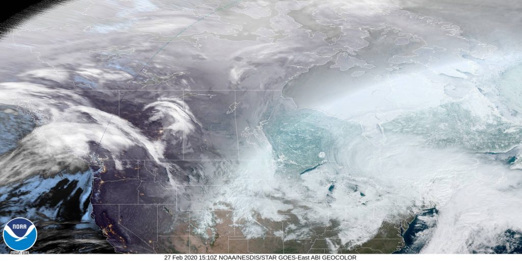
Instead of the radar, like I would normally add when there is precipitation, I have included the satellite imagery from Canada. This is a big area of low pressure stretched across eastern Canada, but it’s not going to last much longer. It’s getting stretched to oblivion as we speak.
Comment (1)