A busy week comes to an end

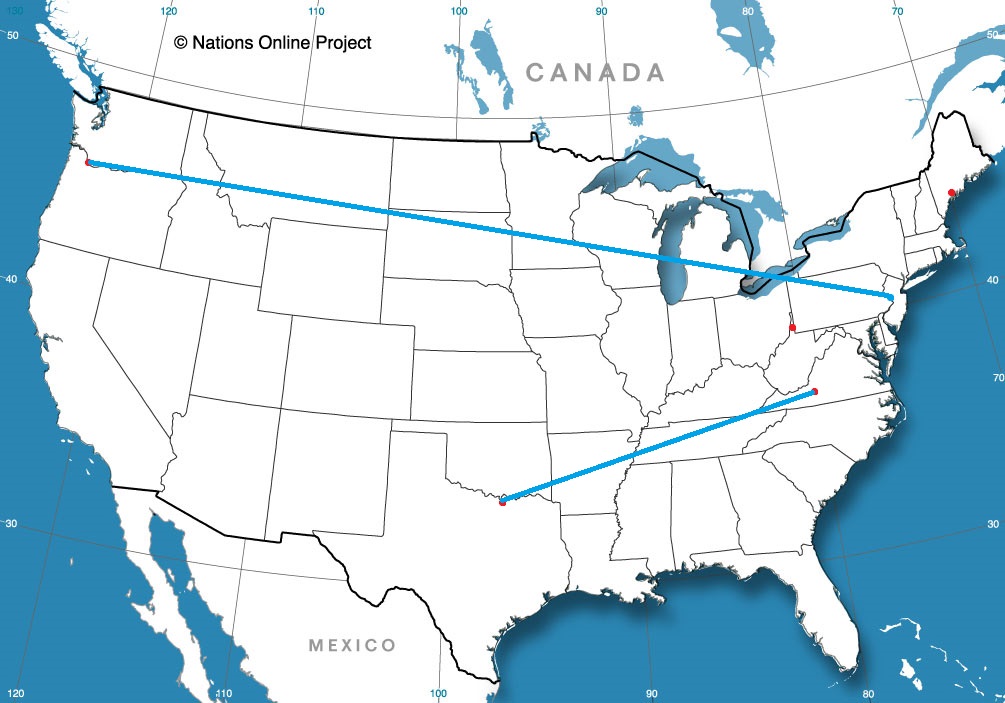
I’m not sure it was planned this way, but Fox Weather sure had a good chance to show off the skills it’s bullpen of meteorologists have, with a pair of severe weather days, first in Missouri on Sunday (Fox covered the aftermath on their launch day) and again in the Sabine Valley from east Texas to western Louisiana, where Lake Charles had a tornado sweep through town only a year after being devastated by the 2020 hurricane season, notably by Hurricane Laura.

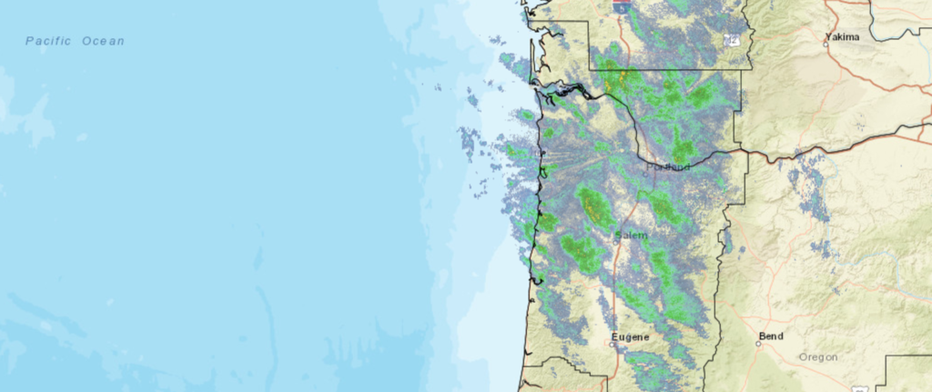
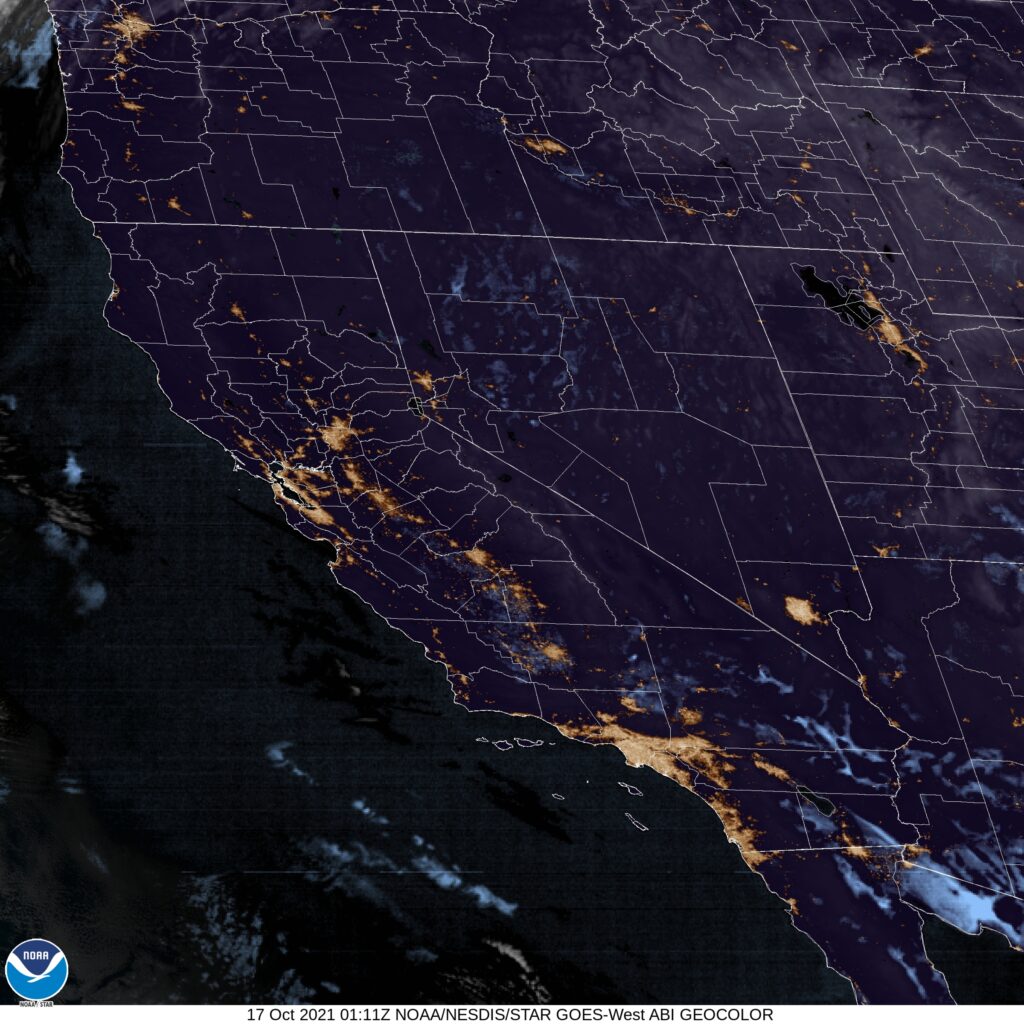
That first round of storms reemerged off shore and drove into southern New England and the mid-Atlantic as a nor’easter, bringing flooding rains around the New York area. There was also more mountain snow and the long awaited conclusion of rain on the west coast, and steady rain at times for nearly everyone in the country as some point, wrought by one of these storms.

The low that was so problematic in the south central United States has become bloated and slow moving. It is now slogging through the eastern Great Lakes bringing intermittent rain to a lot of the northeastern US. Through the weekend, the low will sink off shore, become reinvigorated and blast back north into New England. Behind the feature, cooler than normal temperatures in place, and will be there for the beginning of November.

So how did Fox Weather handle the busy week? Fairly well, I would say. If nothing else, Fox Weather hired people who were comfortable in front of a camera, or were capable of highly produced television. The station is slick, and looks nice. The presenting meteorologists are clear and conversive, and it is a good over the air package.

Unfortunately, all the money was spent on making the streamed product. There is no way for you to get the forecast on their website, and the app is a challenge to use. Fox Weather is essentially a news website with a focus on the weather. You can’t get any forecasts online from Fox. Can you imagine a weather website in which you can’t get your local forecast?

Preposterous.

Portland, Oregon to Trenton, New Jersey

Two cities that are slightly inland, but have been pummeled by extremely heavy rain in the last week. They seem similar, but are separated by 2884 miles. We will take 5 days to cover all this ground, including a really long day at the end, moving at a pace of 67mph, and we will cover about 536.5 miles a day for the first 4 days of the week. If there is anything nasty coming this week, we will sure see it on this trip.

DAY ONE (Thursday)

Portland, Oregon

The next wave of wet weather moving into the Pacific Northwest will really arrive on shore overnight tonight, though rain and some mountain snow has continued to fall from Portland to the Cascades. The wind and precipitation will be heavier through the morning as far east as Biggs Junction than it has been today, but then, it will cut off. The system will be angled towards the north, and should leave the rest of our route on Thursday unmolested. We’ll stop in Wendell, Idaho which is northwest of Twin Falls, for the night.

DAY TWO (Friday)
A ridge is setting up over the Rockies for late in the week, and that coincides pretty sweetly with our trek through the region. Idaho, Utah and Wyoming will be dry on Friday, with seasonable warmth and sunshine. We’ll make it to Arlington, Wyoming, northwest of Laramie on Friday.

DAY THREE (Saturday)
The low pressure feature that was arriving on shore as we attempted to leave Portland is going to ride over the ridge as we head east. It will feature a mostly inactive cold front diving into the northern High Plains on Saturday as we cross the Nebraska prairies. We will make it to Lincoln, where we will stop for the night, amid increasing breezes and temperatures ready to cool down. Now, my alma mater, the Purdue Boilermakers are playing in Lincoln on Saturday, but I swear this is just a coincidence.

DAY FOUR (Sunday)
A cold front is going to be moving at about our pace through Iowa and northern Illinois, but this is probably a good thing. It looks like it will be dry throughout the drive, but will instead just give us a nice little tailwind. Sure, it will feel chilly when we stop for gas, but that gas will come with better mileage! Of course, the stop and go of the Chicago area will slow us down, and we will make it to Hobart, Indiana, just across the border, leaving one final, albeit lengthy day to wrap this bad boy up.

DAY FIVE (Monday)
That crisp breeze will be our companion, only helped, surely, but the Great Lakes to our north. The Appalachians in Pennsylvania will bring respite from the wind, and ultimately the cold, as the East Coast looks to mostly avoid the worst of the cold air brought by the area of low pressure quickly marching towards Hudson Bay. Trenton will be experiencing some partly cloudy skies with southerly breezes when we arrive, a far cry from what they saw last weekend

Portland, Oregon

Our first forecast of the workweek, and perhaps the last of October (I don’t know that, just how slowly I operate) takes us to the teeth of a bomb cyclone/atmospheric river, and a whole lot of climate buzzwords.

At 553AM, PT, Portland was reporting a temperature of 52 degrees with light rain. The Portland metropolitan area was still getting soaked, The rainfall in the Pacific Northwest is ongoing west of the Cascades, but at a lessened rate than it has over the last few days. The strong system in the Gulf of Alaska has moved towards the Panhandle near Sitka and Juneau, which has decreased the westerly flow, but the low level moisture is still available, and the flow is enough that the Cascades will still see steady precipitation with more intermittent rain in Portland.
While all this is good news, it will take until the middle of the day on Wednesday to really wind down, so occasional breezes and rain will be a fixture today and through the beginning of tomorrow. Wednesday afternoon will be the nicest stretch of the forecast, as a secondary, but weaker reinforcing wave is expected to emerge off the Oregon Coast, arriving overnight Wednesday to Thursday. This feature will take a direct shot at the Olympic Peninsula, but Portland will see more rain and wind, especially in the evening on Thursday as the next round slides ashore. This second round will bring a warmer ridge northward, and some warming should be anticipated late.
Tomorrow – Rain in the morning, a bit of clearing late, High 60, Low 50
Thursday – Rain, maybe a rumble of thunder in the evening, High 65,Low 52

TWC: Tomorrow – Cloudy with occasional light rain in the afternoon. High 57, Low 51
Thursday – Rain showers in the morning will evolve into a more steady rain in the afternoon High 65, Low 53

AW: Tomorrow – A thick cloud cover with a little rain High 58, Low 51
Thursday – Mostly cloudy with a couple of showers HIgh 67, Low 54

NWS: Tomorrow – Showers likely before 2pm, then rain likely after 2pm. Cloudy, High 58, Low 50
Thursday – Rain. High 64, Low 50

WB: Tomorrow – Showers likely until afternoon, then rain likely late in the afternoon, High 55, Low 50
Thursday – Rain, High 64, Low 52

WN: Tomorrow – Mostly cloudy with light showers likely, High 58, Low 50
Thursday – Mostly cloudy with rain, High 64, Low 53

FIO: Tomorrow – Light rain throughout the day. High 60, Low 48
Thursday – Light rain throughout the day. High 62, Low 57

We are all over the place in what we expect will happen in Portland over the next couple of days. I’m very interested in seeing how it all plays out.

All hail our robot overlords

When we forecast for Ogden last weekend, I noted specifically that I thought something broke at Forecast.io. Little did I know, it was the rest of us that had the issues. While many of us expected the large system moving into town to bring rain, potentially mountain snow and colder temperatures, Forecast.io didn’t go nearly as cold. Neither did Ogden, as it turned out, and FIO nailed the first three verifying times. Eventually, temperatures fell off quicker than Forecast.io expected, but by that point, they had a commanding lead in the forecast chase.
Actuals: Sunday, High 74, Low 43
Monday – .38 inches of rain, High 63, Low 43

Grade: B-D

Fox releasing a weather app

There will soon be another major player in the weather market. On Monday, Fox is releasing a new streaming weather service and app. They have a weather based website primed to launch as well, but it remains unclear if that will be a traditional site, or if it will host the streaming service.

Some of the features, like the long range forecasts, are silly, and are just ways to try to drive users to the site. The 3d graphics that are promised are a selling point, and the use of local meteorologists across the country is innovative and should bring about some local knowledge that drives effective forecasting.

The elephant in the room, as with all things these days, and particularly when Fox comes up, is politics. Fox News is notoriously conservative in it’s news choices, and that has filtered down into their other media resources. Fox Sports, when they provide analysis, skews conservative as well (If you don’t believe me, listen to Clay Travis just once), and there is a thought that Fox Weather might intend the same.

I think, though, there is space in the market for an explicitly conservative weather outlet, and given the format of the app and stream, it will likely mitigate the most antediluvian tendencies. While climate change is a fairly well grounded scientific principle, it is a political issue and is not well accepted by those with conservative political leanings. While some meteorologists share these stances, they have evolved into questioning the potential impact and appropriate course of action, rather than the veracity of global warming. Additionally, with the network leaning on local weather persons, who may not be directly employed by Fox, there is probably less imperative to follow the corporate mantra.

I think the compromise that we will see at Fox Weather is that, instead of talking about climate change and mankind’s role in the process, and needing to stake a position that may or may not be different than Fox News’ position, the topic will be unaddressed. Instead, Fox Weather, to claim that conservative weather client, will focus only on shorter term forecasts and breaking weather news.

With The Weather Channel leaning heavily into climate change coverage and activism, some people in tornado alley may have drifted away. Having a resource from a brand name they trust providing the important information, they may be more keen to tune in at or ahead of time. As long as the Fox Weather personnel opt for avoidance of the climate change topic rather than being pressured into giving misinformation, I think Fox Weather has a chance to be a benefit to the public safety of our country.

If the Fox Weather site becomes usable like other weather sites we use, there is a very good chance we will see it on these pages in the future. I will also make sure to get the app and will post online any thoughts that come to mind.

A season for change

Since we forecast for Sioux Falls, South Dakota has seen two separate large areas of low pressure have moved through the northern Rockies and the northern Plains. The second round brought snow to the central part of the state, and the first came just 2 hours after our forecast period ended, along with blustery winds and thunderstorms. It wasn’t enough to put the forecast verification too far off kilter, and it sure has shifted the season. The Weather Channel earned the victory.
Actuals: October 11th, High 73, Low 41
October 12th, High 70, Low 43

Grade: A-B

Coming Soon…

It was one of the warmest starts to autumn that we’ve Ever experience. With Halloween around the corner, we might see a bit of a change. If nothing else, the weather might get a little spoooooooky. (Two Portlands in one week is spooky, right?)

Portland, Oregon

Road Trip from Portland to Trenton, New Jersey

Sherman, Texas

Roanoke, Virginia
Road Trip from Sherman to Roanoke

Portland, Maine

Weirton, West Virginia

Springfield, Illinois to Ogden, Utah

Every once in a while, I find myself surprised by the map, and today is one of those times. Ogden is nearly due west of Springfield, and will take a long two days to get to. The mileage is 1,304, and we will take care of 542 of those miles at about 67.7mph on Monday, with the real work coming on Tuesday. If you consider road tripping to be work, of course.

DAY ONE (Monday)

Springfield, Illinois

Did someone say “road trip weather”? No? That’s not something a normal person says? Well, in that case, I will say it. It’s good road trip weather in the middle of the country, and that will continue tomorrow, with high pressure and temperatures that aren’t too hot, aren’t too cold. We’ll navigate through Missouri and into Nebraska, making it past Lincoln to Shelton for our one overnight of the trip.

DAY TWO (Tuesday)
It’s always nice when Day Two is a Tuesday, because it’s significantly less confusing. OK, maybe only for my simple brain. The rest of the drive through Nebraska is going to be serene, but a short waved trough moving through the Rockies will make things significantly more interesting. Rain in the low elevation and snow at higher spots will be seen from Cheyenne westward. We’ll start to emerge from the wet and snow from Rock Springs on westward, and sunshine will return by the time we hit Ogden. Or at least, it would if we arrived when the sun was still up.

Ogden, Utah

Ogden, Utah

I consider myself a geography aficionado. It’s something I am good at, but frankly, I constantly confuse Ogden and Provo. Ogden, if you were curious, is north of Salt Lake City.

At 653PM, MT, Ogden was reporting a temperature of 59 degrees with clear skies. There really weren’t many clouds anywhere across the western United States as residents try to reclaim some autumn after an early shot of snow last weekend.
A fast moving upper level low will rotate through the central Pacific Coast towards Utah, bringing about some clouds to the region, with high elevation snow becoming likely again. Precipitation will arrive on Monday morning, and down by the Lake, Ogden will see only rain. There should be some improvement after sunset, but only at the end of a rainy afternoon.
Tomorrow – Sunny, High 69, Low 41
Monday – Rain through the daylight hours. High 57, Low 42

TWC: Tomorrow – Generally sunny despite a few afternoon clouds, High 70, Low 42
Monday – Cloudy with rain developing later in the day. High 57, Low 44

AW: Tomorrow – Mostly sunny High 69, low 40
Monday – Cooler with clouds and breaks of sun; breezy in the morning with a thunderstorm in spots followed by afternoon showers High 58, Low 41

NWS: Tomorrow – Sunny, High 69, Low 40
Monday – Rain, mainly after 1pm High 56, Low 42

WB: Tomorrow – Sunny in the morning, then becoming partly cloudy, High 67, Low 41
Monday – Breezy. Partly sunny with a slight chance of rain in the morning, then cloudy with rain in the afternoon. High 56, Low 43

WN: Tomorrow – Mostly sunny, High 69, Low 42
Monday – Mostly cloudy with light rain, High 56, Low 50

FIO: Tomorrow – Partly cloudy throughout the day. High 74, Low 43
Monday – Rain until night, starting again in the afternoon, high 63, Low 49

I’m not sure what broker at Forecast.io, but they sure have different forecasts. Forecast lows are all non-standard for Monday, except Weather Nation who don’t have hourly forecasts that deep into the night. The satellite is pretty empty

Autumnal feel in LA

I’m not sure how Californians relate to the change in seasons like we do east of the Rockies, but if they do identify with the seasons, then the air in Los Angeles last weekend was positively fall like. Temperatures were in the 70s in the afternoon, with 50s overnight. If there were deciduous trees in LA, I would think to do some leaf peeping. One thing to take a look at in Los Angeles, though, is the forecast you might get from Weatherbug. They were nearly perfect for a good weather weekend forecast. The gold standard, truly.
Actuals: Saturday, High 71, Low 56
Sunday, High 78, Low 55

Grade: A-C