Pocatello, Idaho

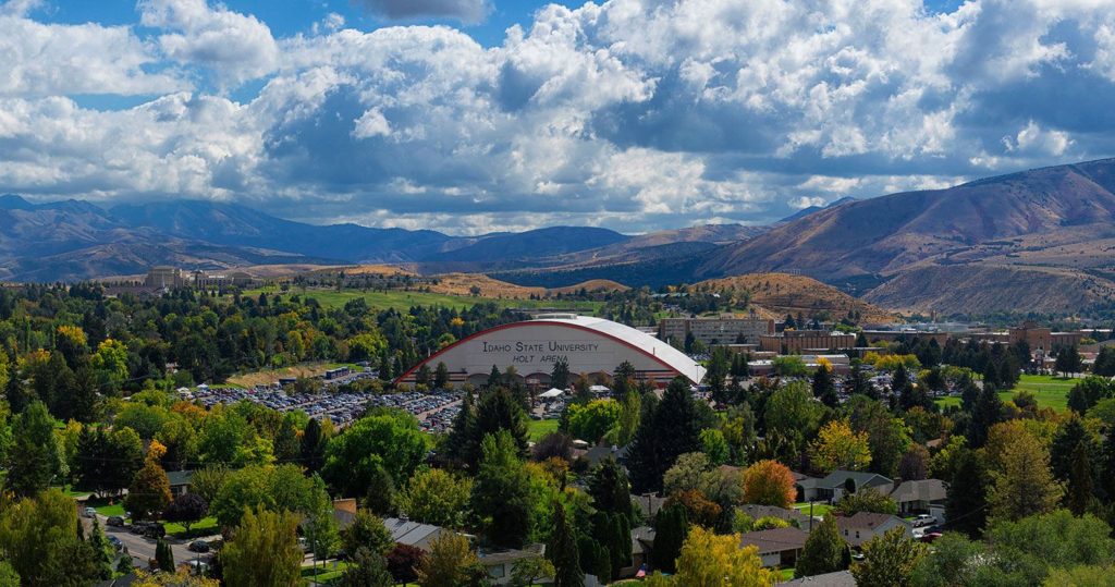
Something about Pocatello always seemed interesting to me. If I’m being honest, I think I just like the way the name sounds.

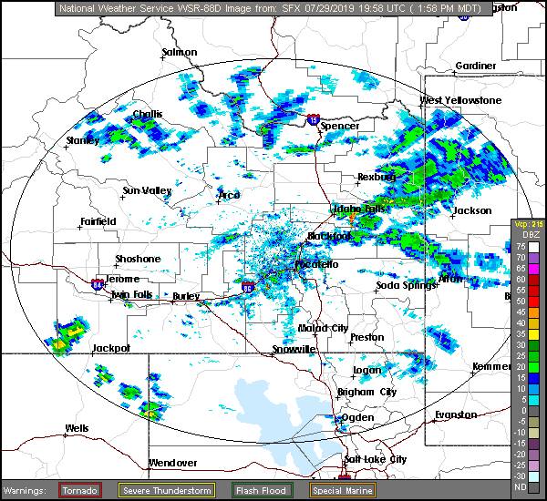
At 127PM, MT, Pocatello was reporting a temperature of 83 degrees with a brisk wind from the northeast, right down the Snake River Valley. There is a general area of showers in the higher terrain east of Idaho Falls contributing to the brisk winds, and any lightning that results from these showers will be particularly dangerous, as the region is tinder dry.
A weak ridge over the Rockies is no match for the monsoon, which will continue to bring showers and storms to the Tetons, particularly in the afternoon for the next two days. Showers and storms aren’t likely to settle down into Pocatello, but similar to today, wind is likely to rush in and the fire threat probably won’t abate.
Tomorrow – Partly cloudy and hot, High 95, Low 53
Wednesday – Mostly cloudy, High 96, Low 57

TWC: Tomorrow – Sunshine along with some cloudy intervals. High 94, low 57
Wednesday – A mix of clouds and sun early, then becoming cloudy later in the day. High 91, Low 61

AW: Tomorrow – Partly sunny; hot High 95, Low 58
Wednesday – Rather cloudy High 92, Low 59

NWS: Tomorrow – Sunny, High 93, low 61
Wednesday – Partly sunny, High 91, Low 61

WB: Tomorrow – Sunny, High 89, Low 57
Wednesday – Mostly sunny, High 88, Low 57

WN: Tomorrow – Mostly sunny, High 93, Low 60
Wednesday – Partly cloudy, High 91, Low 63

FIO: Tomorrow – Partly cloudy throughout the day. High 94, low 59
Wednesday – Mostly cloudy throughout the day. High 93, Low 62

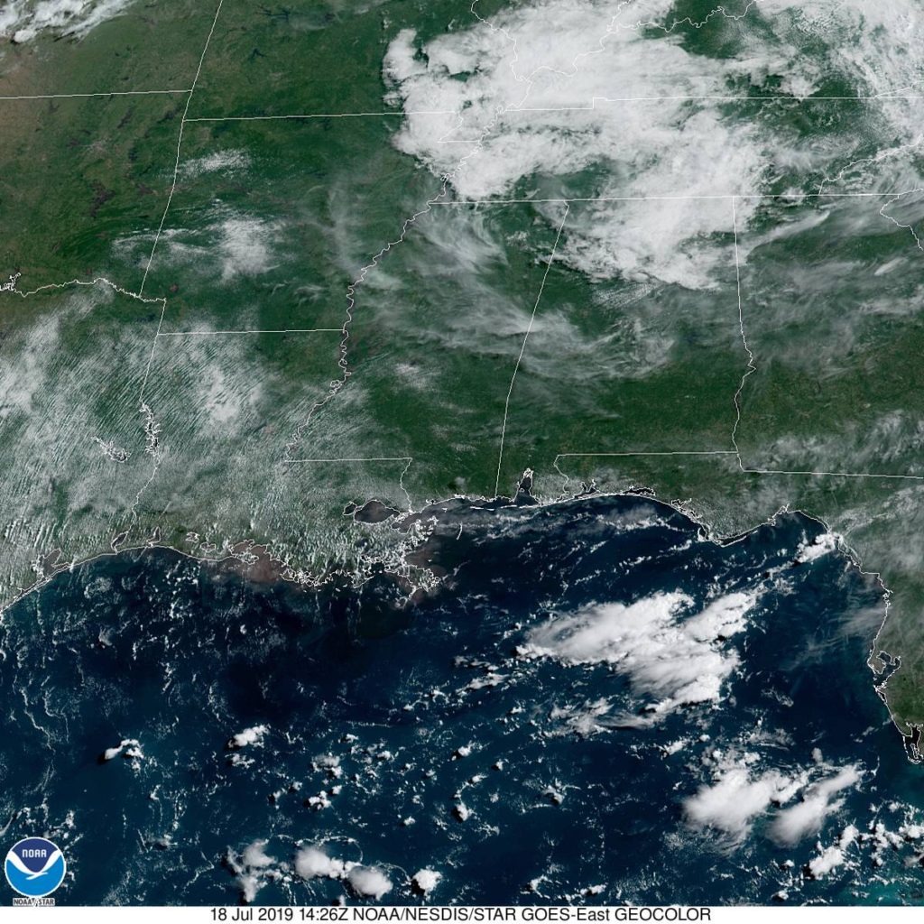
Look at that range in high temperature forecasts! For a forecast with no rain involved, we can brand this as E for exciting. Here is a look at the radar, with those storms over the Tetons.


Always bet on thunderstorms

That’s generally the rule of thumb for forecasting in Florida, especially in the summer months. Last weekend was our valid time for our forecast for Deltona, and there were a handful of outlets that unconscionably left rain out of the forecast one one or both days. Mistake. Because we stuck to our mantra, we won the forecast despite some pedestrian temperature forecasting.
Actuals: Friday – .36″ of rain in thunderstorms, High 95, low 75
Saturday – High 93, Low 75

Grade: B-C

Sumter, South Carolina

Sumter is sort of an in between town. It’s not a coastal town, but it’s not very far inland either. What is the leading factor in the weather in Sumter? I reckon’ we’re about to find out.

At 1055AM, ET, Sumter was reporting a temperature of 81 degrees with sunny skies. After a muggy weekend, an unseasonably strong cold front has swept unpleasantness off the coast, and high pressure has built into the Carolinas.
The remnant boundary will lay astride of the coast, and within the convective remainder, a tropical wave will become involved and briefly intensify before pulling the dry continental air further into South Carolina, and the showers and storms at sea further into the Sargasso. All the while, Sumter looks to enjoy a whole lot of sunshine.
Tomorrow – Mostly sunny, High 89, Low 65
Saturday – Hot but clear, High 90, low 64

TWC: Tomorrow – Sunshine and clouds mixed. High 88, low 66
Saturday – Plentiful sunshine High 89, Low 65

AW: Tomorrow – Intervals of clouds and sunshine High 87, Low 66
Saturday – Mostly sunny High 89, Low 65

NWS: Tomorrow – Partly sunny High 88, Low 67
Saturday – Mostly sunny, High 89, low 65

WB: Tomorrow – Partly sunny High 87, Low 68
Saturday – Mostly sunny, High 87, low 67

WN: Tomorrow – Partly cloudy High 88, Low 67
Saturday – Mostly sunny, High 89, low 65

FIO: Tomorrow – Mostly cloudy throughout the day. High 88, Low 69
Saturday – Partly cloudy throughout the day. High 89, Low 67

All told, especially after this past week, that’s not really a bad outlook for South Carolina. Here is a look at the western Atlantic satellite, showing the instability off shore.

It’s the nights that are oppressive

A lot was made of the heat indices in the 110’s across a broad swath of the Plains east through the Great Lakes to the Mid-Atlantic, but Huntsville is at higher elevation, and was battling an area of low pressure that was bringing clouds to the region and some spots of rain near (but not in) Huntsville on Friday and Saturday. Temperatures, as a result, barely scraped 90. Still hot, but not as hot as it could have been. The problem was overnight, when lows were in the muggy low 70s. That’s tough, as the body can’t cool down and recharge, and is an underrated danger of heat waves. As for the verification of Thursday’s forecast, there was a quartet of forecasters on level pegging: Victoria-Weather, The Weather Channel, Accuweather and Forecast.io.
Actuals: Friday – High 90, Low 73
Saturday – High 88, Low 72

Grade: B-C

Muskegon, Michigan

Today seems to be an interesting day in the weather department, particularly in western Michigan. How interesting? Why don’t we find out?

At 1155AM, ET, despite a stiff breeze off of Lake Michigan, Muskegon was reporting 87 degrees, clear skies and a dew point of 70. While the heat was oppressive nearly everywhere, the instability was mounting. A area of low pressure in the lee of the Rockies extended a weak stationary boundary towards Hudson Bay, and it appears that this is the perfect vehicle for a severe outbreak tonight.
Tomorrow, the stationary front will begin to sink southward as a slow moving cold front, which will bring in more comfortable and more stable air, but before that on Saturday, another similar looking squall line will role through Michigan with a little more intensity than the one that will arrive late tonight. Heavy rain and thunderstorms will be possible, particularly tomorrow afternoon, with lighter rain in the evening. Clouds will linger through the morning on Sunday, however they will clear to the south, and much more moderate air will take over western Michigan to conclude the weekend.
Tomorrow – Clouds, with rain and thunderstorms especially in the afternoon and evening, High 86, Low 72
Sunday – Early clouds then clearing and pleasant, High 80, low 65

TWC: Tomorrow – Partly cloudy in the morning followed by scattered thunderstorms in the afternoon. Storms may contain strong gusty winds. High 86, Low 73
Sunday – Overcast with rain showers at times. High 82, Low 68

AW: Tomorrow – Variable cloudiness, warm, very humid; an afternoon shower or thunderstorm around High 86, Low 75
Sunday – A passing morning shower; otherwise, mostly cloudy High 82, Low 70

NWS: Tomorrow – A slight chance of showers and thunderstorms before 8am, then a chance of showers and thunderstorms after 2pm. Partly sunny, High 87, Low 76
Sunday – Showers and thunderstorms likely, mainly before 8am. Partly sunny, High 82, Low 69

WB: Tomorrow – Partly sunny with a 40% chance of showers and thunderstorms. High 84, low 73
Sunday – Partly sunny until midday, then becoming mostly sunny. A 40 percent chance on showers and thunderstorms, High 82, Low 69

WN: Tomorrow – Partly cloudy with scattered storms, High 87, Low 77
Sunday – Partly cloudy with thunderstorms likely, High 82, Low 69

FIO: Tomorrow – Possible light rain tomorrow evening. High 88, Low 73
Sunday – Mostly cloudy throughout the day. High 84, Low 69

This is the rare non-standard day in the heat of summer. Tonight, the temperature will only get down to about 80 degrees, which is uncomfortable.

Deltona, Florida

With all the focus on the 50th anniversary of the Moon Landing, I think that a trip to the Space Coast and a rapidly developing town near Cape Canaveral is very appropriate.

At 336PM, ET, Deltona was reporting a temperature of 88 degrees, and thunderstorms in the vicinity. In fact, they were reporting lightning from all quadrants. It paints a more aggressive picture than what radar indicates. but there is a band of storms south and east of town that is the most robust.
It’s that time of year for Florida, in which the dynamics are very small scale, reliant on the temperature profiles of see and land as opposed to any broad scale waves. Indeed, Deltona is going to be answerable only to the day time seabreezes as opposed to any broad scale flow pattern. Expect carbon copies of the next two days, with thunderstorms fairly likely, thanks to Deltona’s position set inland.
Tomorrow – Scattered PM thunderstorms, High 95, low 77
Saturday – Scattered PM Thunderstorms, High 95, Low 77

TWC: Tomorrow – Partly cloudy in the morning followed by scattered thunderstorms in the afternoon high 92, Low 75
Saturday – Partly cloudy with afternoon showers or thunderstorms. High 93, Low 75

AW: Tomorrow – Sunshine and some clouds High 92, Low 75
Saturday – Partly sunny, a shower or thunderstorm around in the afternoon High 93, Low 75

NWS: Tomorrow – Mostly sunny and hot, High 95, Low 77
Saturday – A 30 percent chance of showers and thunderstorms after 2pm. Sunny and hot, High 96, Low 77

WB: Tomorrow – Partly cloudy. A chance of showers and thunderstorms in the late morning and afternoon, High 91, Low 78
Saturday – Partly cloudy. A chance of showers and thunderstorms in the late morning and afternoon, High 90, low 78

WN: Tomorrow – Partly cloudy with scattered storms, High 93, Low 76
Saturday – Partly cloudy with scattered storms, High 95, Low 75

FIO: Tomorrow – Humid and partly cloudy throughout the day. High 93, Low 76
Saturday – Humid and partly cloudy throughout the day. High 94, Low 75

Hot and humid. Exactly what we want from Florida in July. Here is a look at the radar in central Florida.

Pittsfield, Massachusetts to Huntsville, Alabama

This drive will straddle the Appalachians, and despite the nexus generally in the Eastern US, we will duck a lot of the traffic trouble. We’re going to take 2 days with a total distance of 1,066 miles. We’ll average 66mph, and will travel 528 miles, a little less than half, on our first day of travel.

Pittsfield, Massachusetts

DAY ONE (Friday)
It’s been a bit active in the eastern United States, but we are looking at a break in the action, at least in the Northeast and Mid-Atlantic tomorrow. A perturbation rolling through the Great Lakes tomorrow will bring some rain to interior New England initially, and reaching the coast by late afternoon. By that time, though, we’ll be well into the Potomac Valley, on our way to Mint Spring, Virginia, which is near Staunton.

DAY TWO (Saturday)
The sunshine will continue while we are to the east of the Appalachians, but as we crest them, we will also begin to intersect the moisture flow from the Gulf. Our drive through Tennessee will be dotted with rain and thunderstorms triggered by flow sneaking up the hillsides, and we will have to navigate this threat for the remainder of our drive. There will be more widespread gaps in precipitation the nearer we are to to Hunstville, thanks to the slightly flatter terrain, but the storms will be based nearer to the surface, which suggests a bit more intensity when we are in them. And gosh dang, will it be hot.

Huntsville, Alabama

My favorite weather related fun fact about Huntsville is that it is the Weather Service office with the smallest geographic footprint. This is because of the preponderance of severe weather, but also because of the historic technical aptitude and home of the space program.

At 853AM, CT, Huntsville was reporting cloudy skies and a temperature of 75 degrees. More importantly, they were also reporting a dew point of 72, ensuring that the morning would have a fairly damp feel, thanks to lingering fog and morning dew and condensation. There was a weak pressure trough in central Tennessee that was kicking up clouds across the region, but they are expected to shift swiftly out of the area, rendering the Huntsville area, along with most of the southeast, extremely warm for the rest of the day.
Low pressure is camped out in eastern Canada and the north Atlantic, without any real plans to leave. This will force a steady southwesterly flow, drawing Gulf moisture through the already sultry air, leaving a persistent threat of afternoon showers and thunderstorms in the region. These are likely to be a blessing, as they should relive some of the heat.
Tomorrow – Scattered thunderstorms, High 91, Low 72
Saturday – Scattered thunderstorms, High 89, Low 72

TWC: Tomorrow – Partly cloudy early. Scattered thunderstorms developing in the afternoon.High 91, Low 73
Saturday – Scattered thunderstorms High 87, Low 73

AW: Tomorrow – Partly sunny (PM storms) High 91, low 73
Saturday – Intervals of clouds and sun, a couple of thunderstorms around High 87, low 73

NWS: Tomorrow – A 30 percent chance of showers and thunderstorms, mainly after 2pm. Partly sunny high 94, Low 74
Saturday – A 50 percent chance of showers and thunderstorms, mainly after 2pm. Partly sunny High 93, low 75

WB: Tomorrow – Partly cloudy, scattered showers and isolated thunderstorms in the afternoon High 90, Low 77
Saturday – Partly cloudy, scattered showers and thunderstorms in the morning and numerous showers and thunderstorms in the afternoon, high 88, low 77

WN: Tomorrow – Partly cloudy with isolated thunderstorms, high 94, low 74
Saturday – Partly cloudy with scattered thunderstorms, High 93, Low 74

FIO: Tomorrow – Possible light rain tomorrow evening.High 90, Low 74
Saturday – Possible light rain in the evening. High 87, Low 73

the GFS and NAM are fairly different in temperature forecasting, and there is a similar discrepancy in forecasts. The NAM is warmer, suggesting fewer storms, but the GFS anticipates more cloud cover. Which will play out? I split the difference, like a coward. Here is that satellite, showing the current clouds in Tennessee and north Alabama.

Pocatello, Idaho to Manchester, New Hampshire

It is a hot and active time in the northern US right now. Where there are no storms, there is blistering heat, but where there are storms, the heat abates. What will we contend with? The heat? The storms? Certainly the humidity? The only way to know is to look into the future, as we forecast for this 4 1/2 day trip, which will cover 2,463 miles. We will collect 532 miles a day. at a modest 66.5mph

DAY ONE (Tuesday)

Pocatello, Idaho

DAY ONE (Thursday)
While things have been a bit tumultuous this week, the biggest, baddest area of low pressure in the Plains is lifting towards Hudson Bay, as though it were a regular winter feature. This will provide a modicum of relieve for waterlogged farmers in the northern Plains, and a great deal of relief for anyone navigating the wilds of Idaho and Wyoming, as we will. There won’t be much to get in our way as we trek eastward, stopping in Egbert, Wyoming by night’s end.

DAY TWO (Friday)
Flow over the mountains will continue to be westerly, and as it ever does, it will fill in the gap behind the previous system with another lee trough. It will be tapped of moisture, though, and will function only to accelerate the warm air from the Gulf to the Plains. Hot and stick in Nebraska, and western Iowa, where we will alight upon Wiota, west of Des Moines, for the night.

DAY THREE (Saturday)
That advancing area of low pressure will start causing problems on our Saturday drive. The GFS, generally agreed to be more reliable in the longer term is indicating widespread precipitation from Iowa to Illinois and Indiana, though I suspect that is a resolution issue. Instead, it’s going to be hot and humid all day, with only a stray thunderstorm here or there. Granted, those storms will likely dump a lot of rain where ever they do show up, which will severely cramp our style. The drive will end in Howe, Indiana, off of the Indiana Toll Road. when we get there depends on how bound up a stray thunderstorm makes Chicago.

DAY FOUR (Sunday)
That area of low pressure from earlier in the trip, the one that we noted would be headed towards Hudson Bay? Well, he’s still going to be there, just hanging out. This will lead to much of the eastern third of the country being active, though not in a terribly organized way. Scattered thunderstorms cropping up in the heat of the day, without any semblance of a plan. This will require us to be vigilant with the wipers from Howe to Syracuse, though there is a chance those showers start tapering off as we role into Syracuse for the night.

DAY FIVE (Monday)
The mishmash of showery humid air will organize a bit to start next week. In New England and New York, this can be a bit more dangerous because of all the tree coverage. A bit of wind can block roadways for hours with the debris. don’t be surprised to see extra traffic through Albany and on to Massachusetts and southern New Hampshire.

Manchester, New Hampshire