Amarillo, Texas

Amarillo is Spanish for “yellow” and was likely named as such because the yellow wildflowers of the region. Now you have learned something.

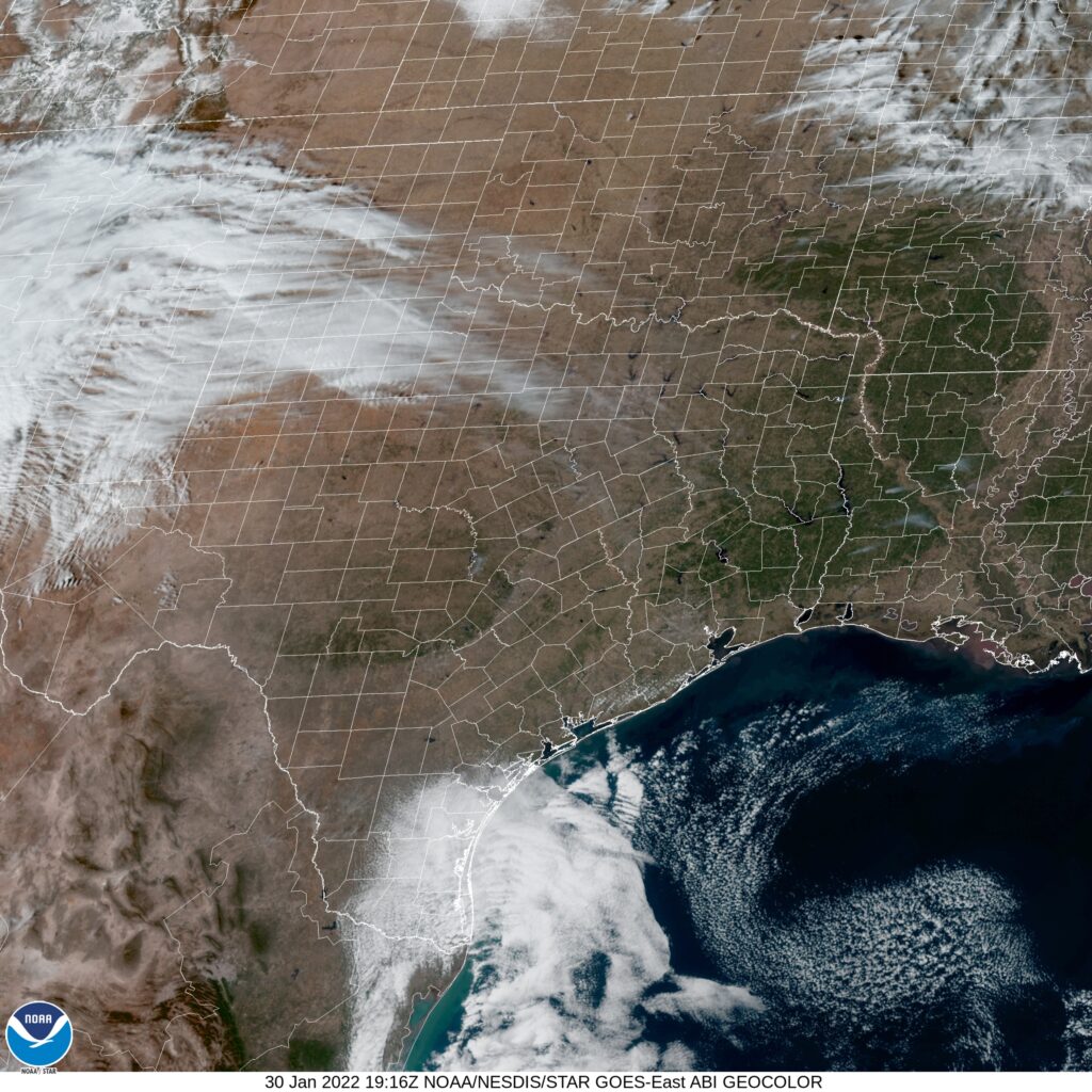
At 1253PM, CT, Amarillo was reporting a temperature of 57 degrees with clear skies. Dry air was present in west Texas, with dew points lingering in the low 10’s, and at Amarillo, it was 11. This sun and dry air will lead to some relatively balmy high temperatures this afternoon. Radar noted some precipitation coming out of New Mexico, but given the low dew points in the region and a lack of observations reflecting the precipitation, it was unlikely any was reaching the ground.
A deep digging upper level trough is generating the clouds and false radar returns in the region, and while low pressure will organize as the trough presses towards the Gulf of Mexico, precipitation will not really blossom until the system can access Gulf moisture, well beyond the ability to influence Amarillo. Monday will be chilly, but with a few morning clouds. A stronger, advancing feature from the Rockies will start to move into the region late on Tuesday. Precipitation will hold off until after midnight, but clouds and a promise of winter weather will encroach on Tuesday night.
Tomorrow – Sunny, High 68, Low 32
Tuesday – Increasing clouds. Cooler, High 50, Low 35

TWC: Tomorrow – Plentiful Sunshine, High 67, Low 29
Tuesday – Windy with increasing cloudy, High 49, Low 33

AW: Tomorrow – Sunshine, High 66, Low 29
Tuesday – Considerable cloudiness and cooler High 44, Low 33

NWS: Tomorrow – Sunny, High 66, Low 31
Tuesday – Mostly sunny High 49, Low 35

WB: Tomorrow – Mostly sunny, High 67, Low 32
Tuesday – Mostly cloudy. Cooler, High 46, Low 34

WN: Tomorrow – Sunny, High 66, Low 31
Tuesday – Partly cloudy, High 49, Lo 34

FIO: Tomorrow – Clear throughout the day. High 66, Low 29
Tuesday – Mostly cloudy throughout the day. High 48, Low 35

That is a pretty dramatic cool down, but take heart. It’s pretty warm there now, though.

NorCal at it’s best (and worst)

I spent a lovely weekend in northern California in the fall of 2019, attending a wedding for one of my best friends. The day before, my wife and I went for a hike in the hills outside of Petaluma, and it was absolutely sweltering. The night of the wedding, in Sonoma, a wind came up during the outdoor reception, and I’m not sure I’ve ever been so cold. Same vibes for Santa Rosa (though a little reversed) during our forecast period. On the 18th, temperatures were several degrees below the forecast totals across the board. On the 19th, however, the reverse was true, and the readings were a bit warmer than any forecast. The result of this temperature and forecast whiplash was a three way draw between Victoria-Weather, The Weather Channel and Accuweather.
Actuals: January 18th, High 54, Low 34
January 19th, High 64, Low 40

Grade: C-D

Radiational cooling where it doesn’t belong

The forecast for Oxnard leaned notably for the marine layer and an onshore flow when it was issued for the weekend of the 7th and 8th. Instead, the off shore Santa Ana breezes were more effective than expected. Sure, one might note the high temperature that hit 73, but that was only a few degrees warmer than the warmest forecast. The real standout was the 41 degree low on Sunday, the 8th. That was up to 10 degrees colder than some forecasts. A qualified SoCal “Brr!”. It wasn’t a great forecast, and Sunday hurt all the way around, but The Weather Channel still gets credit for their first win of the year.
Actuals: Saturday, January 7th – High 60, Low 48
Sunday, January 8th – High 73, Low 41

Grade: C

Santa Rosa, California to Gadsden, Alabama

Let’s set forth on the open road this afternoon, and take a 4 day journey from California to the Southeast. The drive will cover four days, with the final day running very long. At that point, we will be inured to the long driving, though. That’s been my experience. It will be a 2,443 mile journey, paced at a blistering 69.8mph, which means we will cover 558.4 miles a day on those first few days.

DAY ONE (Sunday)

Santa Rosa, California By JLankford – wikitravel, Public Domain, https://commons.wikimedia.org/w/index.php?curid=37654846

As is often the case with drives through California, the weather will be sunny and clear. High pressure in the Intermountain West is producing some gusty Santa Ana winds, so keep your hands on the wheel and be wary of high profile vehicles in other lanes. The drive will start taking us inland, but will mostly be a southward drive. We’ll end up at the Mohave National Preserve in southern California.

DAY TWO (Monday)
These will be good days to continue driving in the southwestern US. It will be the warmest part of cthe country, and will be ensconced in high pressure. A broad trough will be pushing south, but will remain well to our north on Monday. The wind may pick up as a result, but we will still be dry. The day will end on the west side of Albuquerque.

DAY THREE (Tuesday)
That trough I referenced from Monday will help in the generation of a system in the Gulf of Mexico. This isn’t pertinent to our driving conditions on Tuesday, but should indicate how much further the cold air will press south. It’s already chilly in the southern Plains, but it will be well below freezing, even in Midwest City, one of Oklahoma City’s eastern suburbs to finish the day, and it will be cold.

DAY FOUR (Wednesday)
The active weather will continue to be pressed further south, even, than our southern US route. Be wary of drivers from Oklahoma to Alabama, though, as they are not used to even the slightest bit of ice on the roadways. It’s going to be cold in Gadsden, and even I, a Minnesotan, is saying that.

Gadsden, Alabama

A strong start to the new year

The strong start in reference is definitely not a reference to the January posting consistency, but rather how well the National Weather Service handled a challenging forecast in Trenton to start the year. The first round of wet weather of the year slid up the east coast and brought a bit of early morning rain and eventually plummeting temperatures. The NWS threaded this treacherous needle getting only 1 degree of error, and having a proper temperature forecast. A solid start to the new year.
Actuals: January 2nd, .07 inches of rain, High 59, Low 35
January 3rd, High 34, Low 21

Grade: A- C

Santa Rosa, California

We are in the middle of January, and especially those of us on the East Coast are probably pining for some sunny California weather. of course, Santa Rosa is in the North Bay, so we may not be that fortunate.

At 653AM, PT, Santa Rosa was reporting a temperature of 37 degrees with clear skies. There were clouds and fog still lingering to the south over San Francisco and inland towards Modesto, and temperatures there were up to 10 degrees warmer.
There is a weak trough flow in California, which is allowing for the modest on shore flow, bringing enough moisture for some morning clouds and mist along the coast. The trough will strengthen inland over the next couple of days, however, models suggest a lingering coastal trough, perhaps pointing to offshore flow, breezy winds but generally clear skies through mid week.
Tomorrow – Morning clouds and haze possible, High 59, Low 37
Wednesday – Less cloudy and hazy in the morning, a little warmer, High 63, Low 38

TWC: Tomorrow – Partly cloudy, High 59, Low 39
Wednesday – A few clouds early, otherwise mostly sunny. High 63, Low 40

AW: Tomorrow – Times of clouds and sun High 58, Low 38
Wednesday – Partly sunny High 61, Low 40

NWS: Tomorrow – Areas of fog before 10am. Otherwise, mostly sunny, High 60, Low 41
Wednesday – Patchy fog before 10am. Otherwise, mostly sunny High 62, Low 40

WB: Tomorrow – Mostly cloudy in the morning, then becoming sunny. areas of fog in the morning. High 58, Low 44
Wednesday – Partly cloudy in the morning, then becoming sunny. High 61, Low 44

WN: Tomorrow – Partly cloudy, High 60, Low 41
Wednesday – Mostly sunny, High 62, Low 40

FIO: Tomorrow – Partly cloudy throughout the day. High 59, Low 42
Wednesday – Partly cloudy throughout the day. High 62, Low 41

Now, for an alternative take, here is KPIX’s Darren Peck with a look at the weather for the Bay Area.

The last look of the year

Just before we rolled into 2022, I put together a forecast for Erie, which turned out to be quite sodden. Sure, it was unusually warm for northeastern Pennsylvania as the new year arrived, but a cold front an a system coming out of the Ohio Valley conspired to make sure the warmth was wasted, and it rained for most of the first two days of the year. Temperatures continued to drop through the first two days of the year, and while it was in the mid-50s on New Years Day, it was merely 22 on the 2nd. This forecast, since it started on the 31st counts as the last of 2021, and gets awarded to Weatherbug. Fitting, given how many forecasts they won this year.
Actuals: Jan 1st, .48″ of rain, High 54, Low 37
Jan 2nd, .15″ of rain, High 37, Low 22

Grade: B-D

Coming soon…

Perhaps we have finally found our 2022 groove. We’ll check to see if that is the case as we put together forecasts across the country, with a couple of stops in Texas

Road Trip from Santa Rosa, California to Gadsden, Alabama

Amarillo, Texas

Hickory, North Carolina

Lima, Ohio
Road Trip from Laredo, Texas to Lima

Oxnard, California

As I get this post set up and prepped, I would like to note that it was -20 here at the Victoria-Weather offices today. It’s that attitude I get to take to this forecast for southern California.

At 551PM, PT, Oxnard was reporting a temperature of 55 degrees with overcast conditions. A large area of low pressure in the Pacific Northwest was influencing weather across the western US, with a stream of clouds, and some onshore flow over southern California. Oxnard had broken out a bit more than their counterparts to the south, as Los Angeles was also experiencing some early evening haze.
High pressure is going to build back in, but it won’t eliminate the near coastal moisture. Clouds will likely be problematic in higher terrain, but they will just momentarily blot the sun through the weekend in Oxnard. Expect the threat for fog to arise overnight, though not as significantly as will be found to the south. Off shore flow will ensure that the haze doesn’t linger during the day.
Tomorrow – Early haze, mostly cloudy, High 60, Low 50
Sunday – Mostly cloudy, High 67, Low 48

TWC: Tomorrow – Partly cloudy skies. High 59, Low 48
Sunday – Partly cloudy. Strong Santa Ana winds possible. High 67, Low 46

AW: Tomorrow – Clouds giving way to some sun and cool, High 59, Low 47
Sunday – Mostly sunny High 65, Low 47

NWS: Tomorrow – Patchy fog before 10am. Otherwise, partly sunny High 59, Low 46
Sunday – Mostly sunny, High 64, Low 45

WB: Tomorrow – Low clouds and fog in the morning, then sunny, High 60, Low 47
Sunday – Sunny in the morning, then partly cloudy, High 66, Low 48

WN: Tomorrow – Partly cloudy, High 60, Low 46
Sunday – Partly cloudy, High 65, Low 45

FIO: Tomorrow – Clear throughout the day. High 63, Low 49
Sunday – Partly cloudy throughout the day. High 70, Low 51

I’m going to really take a look at those winds on Sunday. I just don’t see it being that breezy in Oxnard. Satellite shows the mid layer clouds as well as a thatch of low clouds and haze south of the Oxnard area.

Erie, Pennsylvania to Trenton, New Jersey

Trenton is right on the border with Pennsylvania, but you couldn’t ask for a longer drive into the next state over. It will take a whopping 6 1/2 hours to cover the 435 miles across the Keystone state,. The pace will be 65mph, which seems faster than I anticipated. Road trip 2022!

Erie, Pennsylvania

A large juggernaut of low pressure is battering the mid-Atlantic today, getting perilously close to the Trenton area. Pennsylvania itself is under the grips of a chilly high pressure. The nice thing about big areas of organized low pressure is that they move, and do so swiftly more often than not. The low will be headed for Newfoundland by the time we awake tomorrow morning, and Trenton, just like the entirety of Pennsylvania, will be cold but sunny and dry.

Trenton, New Jersey