Trenton, New Jersey

Erie is going to go down as a 2021 forecast, so here it is, the first official forecast of 2022.

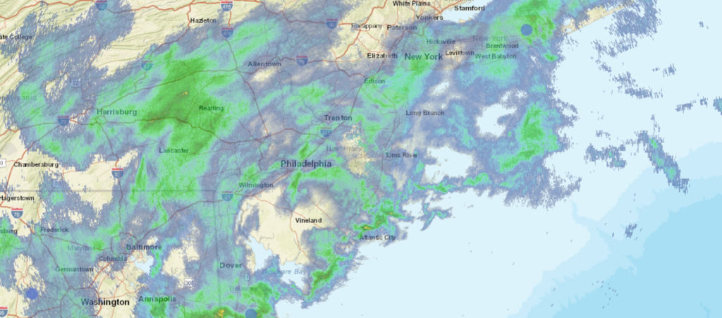
At 1153PM, ET, Trenton was reporting low clouds and rain, with a temperature of 53 degrees. S cold front over the eastern Great Lakes is being held up by a developing and active area of low pressure. The cold front is backed by a deep cold pool, and that conflict of air mass is helping the low in the Poconos to continue to strengthen. In the short term, this means rain for Trenton.
The initial feature will move towards the Canadian Maritimes, but the upper level dynamics in the region will remain unchanged. A deeper, stronger area of low pressure will emerge in the southeast while the cold front starts to sink towards Trenton. The cold air will arrive before the northeastward moving low pressure center, and as a result, snow is anticipated, at the very least to mix in on Monday, particularly around midday. This second feature is going to be stronger, windier as well as being more quickly moving. By the end of the day, it will be quite a bit clearer.
Tomorrow – Rain likely through much of the day, High 57, Low 36
Monday – Rain mixing to snow, clearing late, High 36, Low 25

TWC: Tomorrow – Overcast. Slight chance of a rain shower High 59, Low 37
Monday – Scattered snow flurries and snow showers before noon. Becoming partly cloudy later. High 36, Low 23

AW: Tomorrow – Considerable clouds and mild; a little morning rain followed by a passing shower this afternoon High 56, Low 35
Monday – Clouds giving way to some sun and much colder High 34, Low 24

NWS: Tomorrow – A chance of showers before 11am, then a chance of showers after noon. Patchy fog before 11am. Otherwise, cloudy, High 59, Low 35
Monday – Mostly sunny High 34, Low 22

WB: Tomorrow – Patchy fog in the morning. Cloudy with a 40 percent chance of showers, High 59, Low 37
Monday – Mostly sunny, High 37, Low 25

WN: Tomorrow – Mostly cloudy with light rain showers High 59, Low 36
Monday – Partly cloudy, High 36, Low 33

FIO: Tomorrow – Light rain overnight and in the morning. High 61, Low 35
Monday – Overcast throughout the day. High 36, Low 24

A bold move by other outlets keeping precipitation out of the picture entirely on Friday. Still, and especially with snow flurries, it tends to get everywhere. I don’t think anyone will cut precip out of the forecast on the coast in their forecast for Monday afternoon and evening. Here is all the rain around the region tonight.

nton

A very merry forecast

On Christmas Eve, while all the children were snug in their beds with sugar plums dancing in their heads, we were stirring with a forecast for Sebastian, Florida. It made me pine for the years I spend in Florida, as highs were near 80 on Christmas and the day after, with barely a cloud in the sky. With the way this month has gone, it nearly rates as a Christmas miracle, but Victoria-Weather had the top forecast for Sebastian.
Actuals: Saturday (Christmas), High 80, Low 53
Sunday – High 78, Low 53

Grade: A-C

Erie, Pennsylvania

We are starting the year as urgently as possible, as this forecast will post just as the day turns to 2022. Erie is right in the middle of the south shore of the lake that bears its name, and is susceptible to lake effect snow this time of year. Will Erie start 2022 on a snowy note?

At 1211AM, ET, Erie was reporting a temperature of 47 degrees with light rain. Heavier rain was falling between Erie and Buffalo than in either of those cities, but with temperatures warm enough even at this early hour, the threat for snow to accompany the rain can be ignored. A cold front lies through southern Ontario, helping to generate the few showers on the southeast side of Lake Erie, but a broad, distended area of low pressure stretches along the Ohio Valley, and is a focal point for more robust showers, with some thunderstorms on the south side of this feature.
For at least the next day or so, these two features will run in parallel. The low over the Ohio Valley will slide just to the south of the cold front, holding the boundary in place the whole while. As the Ohio Valley feature shifts into the Canadian Maritimes, the front will start to shift a little bit more to the southeast, bringing about colder air and a significant threat for snow, somewhat amplified by the Lake. After holding steady through the mid afternoon tomorrow, temperatures will get steadily colder, and are likely to be non standard through the weekend.
Tomorrow – Scattered showers, overcast, High 49, Low 42
Sunday – Early rain, followed by snow through the day, High 42, Low 27

TWC: Tomorrow – Showers early, becoming a steady rain later in the day. High 51, Low 38
Sunday – Snow during the morning will transition to snow showers during the afternoon. High 38, Low 25

AW: Tomorrow – A thick cloud cover and mild with a little rain; a wet start to the new year High 50, Low 38
Sunday – Rather cloudy and colder with snow showers, accumulating an inch or two High 39, Low 25

NWS: Tomorrow – A chance of showers before 2pm, then rain likely, mainly after 4pm. Cloudy, High 51, Low 40
Sunday – Rain and snow showers, becoming all snow after 11am. High 40, Low 27

WB: Tomorrow – Cloudy. Patchy fog in the morning. A chance of showers in the morning, then rain in the afternoon. High 50, Low 37
Sunday – Rain showers in the morning. Snow showers. Light snow accumulation. High 37, Low 25

WN: Tomorrow – Cloudy with light rain, High 51, Low 39
Sunday – Mostly cloudy with a light wintry mix, High 39, Low 32

FIO: Tomorrow – Rain until night, starting again in the afternoon. High 47, Low 36
Sunday – Possible light rain (with a chance of 1–2 in. of snow) overnight and in the morning. High 37, Low 22

WeatherNation with a rough start for the year, having the shortest hourly forecast. Of course, it is longer than it used to be, so their forecast is going to be better than we are accustomed to. Radar is most active northeast of Erie. Happy New Year!