Ahead of the Thanksgiving travel season, a storm system passed through the American southeast before petering out in the mid-Atlantic. There were some outlets that thought that it could lead to a bit of a severe weather outbreak around our forecast destination of Birmingham last Friday and Saturday, but fortunately, that didn’t come to pass. The whole feature was a bit messier than it could have been, and left some light showers in the region on Saturday as well as Friday, and didn’t bring the cold pool behind it that was in the forecast for some. It hit 80 last Saturday! Clime came away with the top forecast, thanks to a being one of the warmer forecasts on Saturday. Actuals: Friday . 06″ of rain, High 71, Low 57 Saturday .03″ of rain, High 80, Low 55
Between the early start to tornado season and the exposure to hurricane season, Alabama is one of the more interesting places to forecast the weather. Undoubtedly, this is why James Spann, one of the more famous TV weatherpeople has built such a respected reputation, working in Birmingham. Perhaps we have an interesting forecast in our future?
At 1053PM, CT, Birmingham was reporting a temperature of 61 degrees with overcast skies. There was weak ridging in the area tonight, helping to provide some stability, however a weakening disturbance over the Southern Plains is advancing to the east, and the attendant warm front runs through Tennessee. The rest of the energy will arrive in the late morning tomorrow, with light rain and an isolated rumble of thunder. The back end of the energy lies well west of the precipitation that will begin tomorrow morning. Expect the coverage and intensity to pick up late tomorrow evening into Saturday morning. The tailing cold front will stall across central Alabama, leading to an ongoing threat of light rain to start the weekend. Fortunately, there is an area of surface high pressure behind the wave moving in overnight tonight, and the latter half of the weekend will be clearer. Tomorrow – Scattered showers and isolated thunderstorms, High 72, Low 58 Saturday – Mostly cloudy with a smattering of light rain, High 75, Low 57
TWC: Tomorrow – Rain showers in the morning with thunderstorms developing in the afternoon. High 70, Low 58 Saturday – Showers in the morning, then partly cloudy in the afternoon. Thunder possible. High 77, Low 58
AW: Tomorrow – Rather cloudy with a heavy thunderstorm in the afternoon; thunderstorms can bring hail and damaging winds High 72, Low 60 Saturday – Mostly cloudy and warm High 75, Low 53
NWS: Tomorrow – Showers likely, with thunderstorms also possible after 3pm. Mostly cloudy, High 72, Low 59 Saturday – A 20 percent chance of showers and thunderstorms before noon. Cloudy through mid morning, then gradual clearing, High 72, Low 58
WB: Tomorrow – Mostly cloudy. A chance of showers in the morning then showers likely with a chance of thunderstorms in the afternoon. High 70, Low 63 Saturday – Mostly cloudy with a slight chance of showers and thunderstorms in the morning then sunny in the afternoon. High 74, Low 60
WN: Tomorrow – Mostly cloudy with light showers and a chance of storms, High 72, Low 59 Saturday – Partly cloudy with isolated storms, High 76, Low 60
CLI: Tomorrow – Thunderstorm, High 72, Low 58 Saturday – Light rain showers, High 77, Low 55
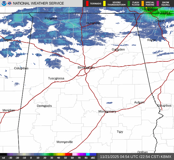
I think the response to the boundaries and clouds associated with this fairly quick moving system could really play havoc with this forecast. I should note that the low temperatures on Saturday are expected to occur at midnight leading to Sunday. The radar is showing off some showers, but few are reaching the ground….. yet.
Birmingham was getting ready for a line of thunderstorms as we put our forecast together last Wednesday. After the line went through, temperatures were cooler and it was dry to end February. Things took a turn on Friday, when the next round of wet weather moved into town. This round brought about .8″ of rain, a not insignificant amount, and certainly a bad sign for the weekend. If one believes in omens, this must also mean that the month of March will be out like a lamb in Birmingham, so that’s a good sign, right? Victoria-Weather easily won the forecast. Actuals: Thursday: High 50, Low 37 Friday: .81″ of rain, High 51, Low 45
Should we try to get kind of crazy today? Let’s try to get two forecasts in in one day!
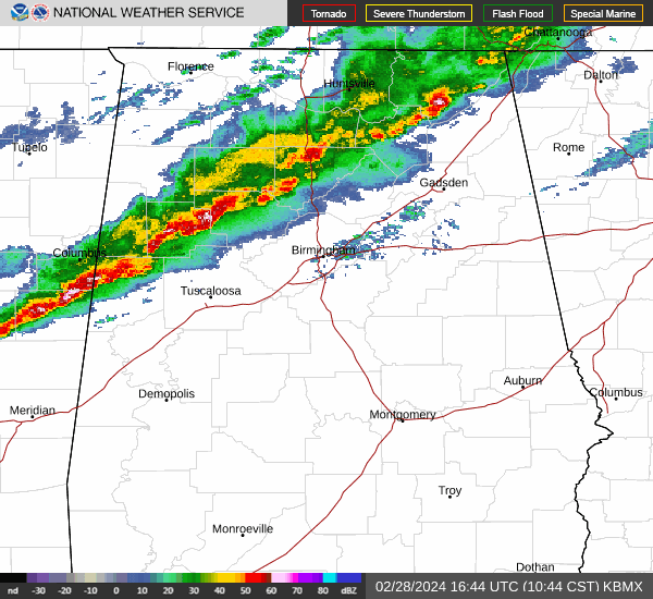
At 1053AM, CT, Birmingham was reporting a temperature of 73 degrees with light rain. The rain was popping up on radar a few miles ahead of more significant weather. Thunderstorms will be moving into Birmingham within the hour, and are presently lined up from north of Warrior to north of Aliceville, and will bring primarily a threat of some gusty winds, rain and thunder. A healthy cold pool will chase the front out of town, leaving a cool afternoon in northern Alabama, followed by a crisp morning tomorrow. The jet structure is bifurcated right now, so despite a strong ridge to the north, Texas will be a ripe environment for cyclogenesis late this week. A much weaker feature than either the storm that is going to sweep through momentarily, or the strong system preparing to slam the west coast will develop in Texas and slide into Alabama on Friday morning, bringing a few showers and storms to Alabama’s largest city. Tomorrow – Mostly sunny and chilly, increasing clouds late, High 52, Low 37 Friday – Scattered showers, cloudy, High 52, Low 47
TWC: Tomorrow – Cloudy skies, slight chance of a rain shower, High 55, Low 36 Friday – Cloudy with periods of rain, high 54, Low 45
AW: Tomorrow – Mostly cloudy and cooler High 53, low 36 Friday – Periods of rain and a thunderstorm High 54, low 46
NWS: Tomorrow – Partly sunny, High 54, low 34 Friday – Showers and possibly a thunderstorm High 53, Low 45
WB: Tomorrow – Partly sunny, High 55, Low 39 Friday – Showers, a slight chance of a thunderstorm in the morning, then a chance of a thunderstorm in the afternoon, High 53, low 49
WN: Tomorrow – Mostly Cloudy, High 56, Low 35 Friday – Mostly cloudy with showers and chance of storms, High 53, Low 45
CLI: Tomorrow – Light rain showers, High 59, Low 33 Friday – Rain showers, High 56, Low 45
We see a lot of towns in Alabama, but we don’t often touch on Birmingham. While we are here, we are getting some active weather, though! Radar shows this line of thunderstorms on the door steps.
The historic snow in the northern United States this winter is leading to some significant flooding impacts, starting in Minnesota, but probably working downriver. Our route, less than a day between Alabama and Arkansas, covering 361 miles, cross the mighty Mississippi at Helena, Arkansas, where the River is already pretty wide, and the bridge is tall. Hopefully, that means the only worries we end up having are with the ongoing weather impacts, rather than the impacts of precipitation many months ago. We’ll pass by the Mississippi Valley at a meandering 60mph pace, which at this rate, might take us a full 15 minutes to drive over the bridge.
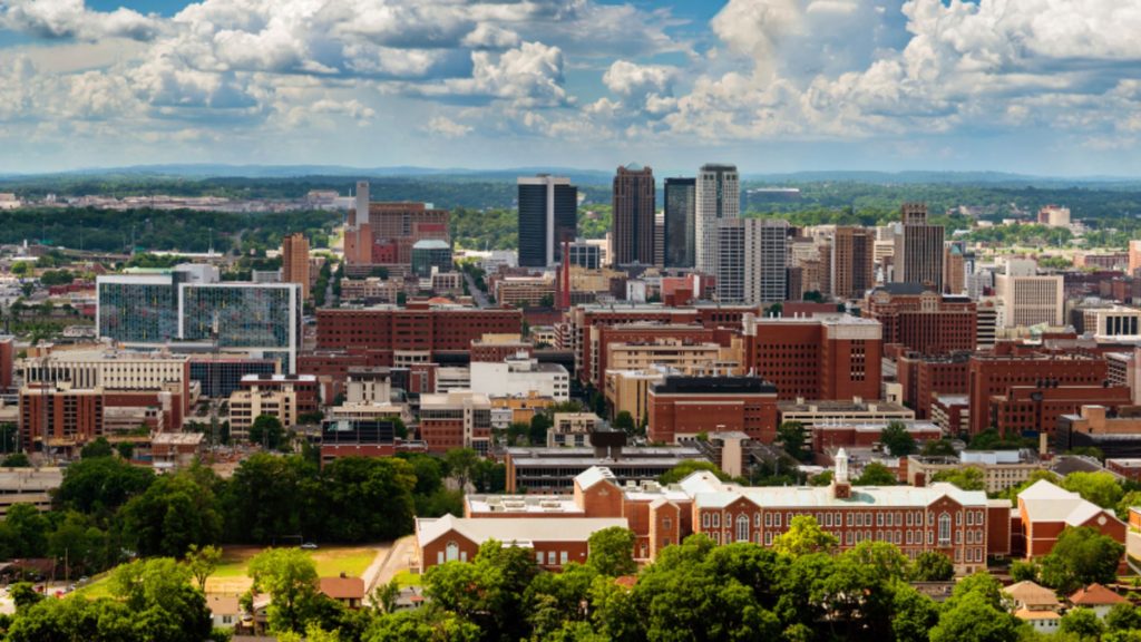
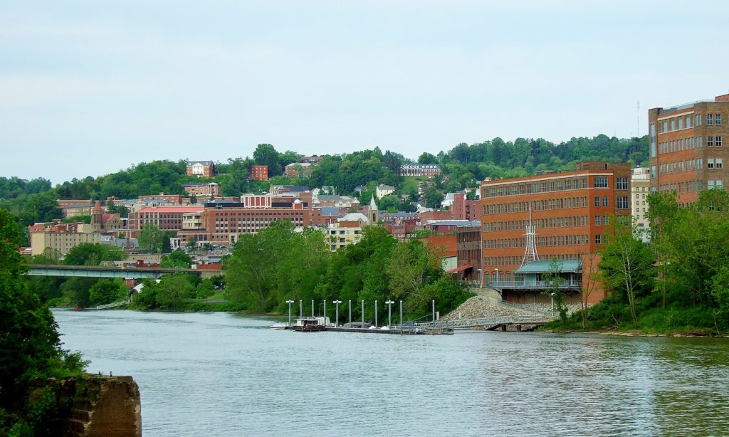
Birmingham, Alabama
If you find yourself living in any part of the United States’ contiguous states, you are probably experiencing or will soon experience, below normal temperatures. If not, you are probably on the West Coast, and this blog is probably not the first click in your morning surf. But the below normal weather in the east is the result of a stout area of high pressure extending from Canada all the way into the American Southeast. This will keep the drive through Alabama and Mississippi pretty tranquil. An area of low pressure is going to start emerging tonight and tomorrow in the Southern Plains and start to feast on moisture banked in Texas. A weak warm front will start sneaking north in Arkansas which could bring some late puffy cloudy to the Pine Bluff area. They aren’t likely to bring rain before our drive is over, but expect a wet middle to the week in Pine Bluff.
The forecast for Birmingham was a fairly straightforward one, dry and HOT. Which is was, no doubt about that. The morning lows were a couple degrees cooler than most had anticipated however, which lead to some higher than average scores given the comparatively benign pattern. NWS and WeatherNation split top billing.
Friday: High 98, Low 67.
Saturday: High 100, Low 67.
Forecast Grade: B
Today we embark on a 2-day, 677-mile trek through the Appalachians to the Deep South. We could probably get this one in one very long day, but we’re gonna take our time and enjoy some scenery!
DAY ONE
High pressure is found over the OH and TN Valleys, keeping much of the region dry into the Central and Southern Appalachians. A sunny day is expected as we head south out of Morgantown through WV and through western Virginia. Continued pleasant but hot conditions are anticipated for the rest of the day as we end this leg in Knoxville.
DAY TWO
As high pressure continues to control the region, more sunny skies and dry conditions are expected for the rest of the trip. Temperatures are expected to hit the triple digits as we head past Chattanooga into Alabama and eventually into Birmingham, but at least the trip will be dry!
As we look forward to the weekend, let’s head to the Deep South and see how the historic city of Birmingham will fare!
At 953pm CDT, the temperature at Birmingham, AL was 80 degrees under fair skies. It’s been nothing short of ridiculously hot over the Southeast this past week as I mentioned a few days ago, and it doesn’t look like it’s gonna go anywhere soon. A strong ridge of high pressure is continuing to sit over the Deep South and will park itself there for another couple of days yet. It will break down a bit on Sunday and a chance of thunderstorms will re-enter the forecast. But until then, it’ll be dry but scorching hot!
Friday: Sunny and hot. High 95, Low 71.
Saturday: Sunny and even hotter. High 96, Low 69.
TWC: Friday: Sunny. High 96, Low 70.
Saturday: Sunny. High 98, Low 70.
AW: Friday: Mostly sunny. High 96, Low 70.
Saturday: Mostly sunny; hot. High 98, Low 68.
NWS: Friday: Sunny. High 98, Low 70.
Saturday: Hot. High 100, Low 71.
WB: Friday: Sunny. High 95, Low 71.
Saturday: Sunny. High 97, Low 70.
WN: Friday: Sunny. High 98, Low 70.
Saturday: Mostly sunny. High 100, Low 71.
FIO: Friday: Clear throughout the day. High 95, Low 70.
Saturday: Clear throughout the day. High 97, Low 69.
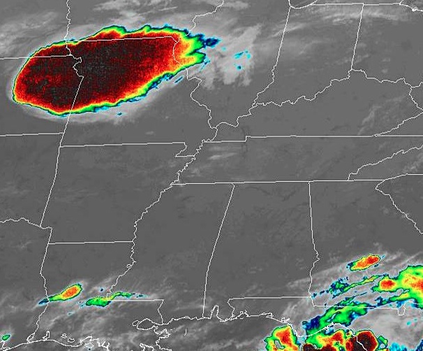
The Deep South is extremely quiet tonight, and looks to remain that way as we head into the weekend. Just don’t look at that cluster of severe thunderstorms in MO/NE. Nothing to see here folks!