Strong storms and rain made for a pretty eventful week last week in the north central United States. If eventful doesn’t work for you, then perhaps Duluth is the right town for you. With forecasts in the low 70s on the 13th and showers and storms in the forecast, Lake Superior guffawed and sent low level moisture, fog and clouds into the city. Temperatures didn’t even get out of the 40s. As a result, the warm nights were not seen either, and the low temperature on the 14th, which ultimately did see sun and a return to the 70s, dipped to the 30s when low 50s were expected. It was a completely busted forecast, but Accuweather was the least terrible of a rotten forecast. Actuals: May 13th – .24 inches of rain, high 48, Low 41 May 14th – High 73, Low 39
Before I got the map for this trip, I wondered if it would take us through the Twin Cities or the Upper Peninsula, and it turns out, it was neither. It’s going to be a one day trip that takes us 627 miles and right through Chicago. The route through rural Wisconsin, followed by the decidedly not rural Chicago will slow us down to a 61mph pace, but that’s ok because we are getting it all done in one day.
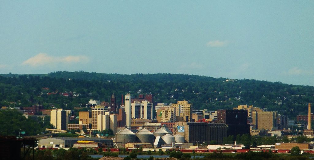
Duluth, Minnesota
I found what might be the least attractive angle of Duluth I could, just because the intent is to leave this fine city for Indiana. We will be between systems as we set forth tomorrow, which makes for a much easier drive. A warm front lifting north ahead of the next feature coming eastward will touch off some late showers or convention (probably convection, frankly) in northern Wisconsin. We will likely steer clear of the wet weather before it initiates, and will only deal with a hot, stuffy traffic jam late in the afternoon in Chicago, before we trundle on in to Kokomo.
Duluth is one of the most underrated cities out there, in terms of culture, activity and overall beauty. It’s a real treasure on Lake Superior, and frankly feels a little out of place in Minnesota.
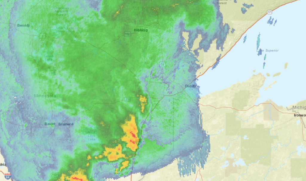
At 1155AM, CT, Duluth was reporting overcast skies with a temperature of 52 degrees, and rain. Much of northern Minnesota was caked in rainfall, thoruhg a line of thunderstorms from Moose Lake to St. Cloud was also progressing to the east. A perturbation along a rising warm front was more active, it seemed, than expected, but a warm up to the south and west of Duluth promised another ominous day of convection in Minnesota and the Dakotas. Short range models indicate a clearing later this afternoon, which would provide for a warmer afternoon. Additional strong thunderstorms will emerge in the Red River Valley in the early evening, but whatever comes from those will not reach Duluth until close to midnight. There is a threat for some gusts with these storms, but the real danger is on the other side of the state. The jet is north to south and will direct the parent low that direction. As a result, behind the front will be substantially warmer than a typical May cold front. This will lead to a bit more instability, and clouds are likely Friday, and a post frontal trough could bring a bit more rain on Saturday. Tomorrow – Partly to mostly cloudy. Rain and thunder before dawn, High 73, low 49 Saturday – Partly cloudy, chance of some afternoon rain, especially away from the Lake, High 71, low 50
TWC: Tomorrow – Intervals of clouds and sunshine (Early storms), High 65, low 45 Saturday – Sunshine and some clouds. A stray shower or thunderstorm is possible High 69, Low 51
AW: Tomorrow – Mild with clouds followed by a brightening sky (early storms)High 67, low 44 Saturday – Mostly sunny High 69, Low 51
NWS: Tomorrow – Mostly cloudy, then gradually becoming sunny (early storms) High 70, Low 49 Saturday – Sunny, High 70, Low 52
WB: Tomorrow – Mostly sunny (early storms(, High 70, low 47 Saturday – Sunny. A 20 percent chance of rain showers in the afternoon, High 69, low 52
WN: Tomorrow – Partly cloudy with light rain showers, high 70, low 49 Saturday – Mostly sunny, High 70, Low 51
FIO: Tomorrow – Foggy overnight and in the morning. High 73, low 45 Saturday – Partly cloudy throughout the day. High 69, Low 54
This is a lot of rain. Good news for fans of Gooseberry Falls, at least.
Low pressure was sliding it’s way northeast and away from northern Minnesota during the middle of last week. There was even the suggestion that a snowflake could fall near Duluth early on Thursday morning, with some chilly raindrops a sure bet. Indeed, there was a drop or two of rain but it never cooled enough for snow at Duluth. Temperatures did plummet on Friday morning, diping to the mid 20s, but then, they recovered all the way to the low 60s on Friday afternoon. The Weather Channel and Victoria-Weather ended up locked horns for the tie in Duluth. Actuals: Thursday – .09 inche of rain, High 52, Low 37 Friday – High 63, Low 26
Google recommends two routes between Ogden and Duluth. One of them only has Fargo as the largest town between the two destinations. We’re going to take a more southerly route, in which we will pass through the Twin Cities. It’s a little less lonely. The drive will take 2 1/2 days and cover 1381 miles. Our pace will be 67.1mph, which means that the first two days will intend to conclude after 536.7 miles. Hope you like country music, because I bet there isn’t much else on the radio.
DAY ONE (Friday) The worst place to get stuck in the weather is the mountains. Slick roads plus climbs and drops and it can get a little dicey. Well, we are in Utah, and they don’t like dice. There will be high pressure in the northern Rockies tomorrow, holding a developing area of low pressure up in Canada while it warms up along our route. We will get to the sleepy eastern Wyoming town of Mule Creek, which is north of Lusk.
DAY TWO (Saturday) Another advantage to the southern route, aside from seeing actual human beings, is that the area of low pressure moving through Canada won’t carry enough cold air or momentum to intercept us as we pass through South Dakota or southwest Minnesota. We’ll make it to Mountain Lake, Minnesota with dark clouds with no rain on the northwestern horizon as we end the day.
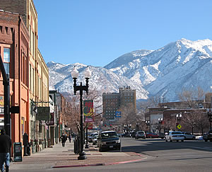
DAY THREE (Sunday) If there is any precipitation with the passage of this cold front, it will be overnight as we recline in Mountain Lake. The cold front will be through southern Minnesota, so cool conditions will return as we head towards Duluth. Duluth is a very nice town, and because of Lake Superior it is always a little cool. Bring a jacket!
It’s the middle of April, and, disgusting though it may sound, we can’t officially exclude snow from the forecast. Not without a thorough examination, anyway.
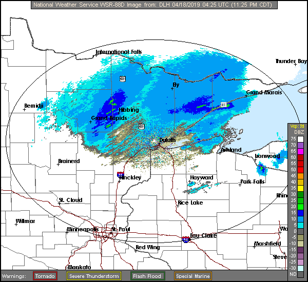
At 416PM, CT, Duluth was reporting a temperature of 41 degrees with drizzle and a brisk northwest wind. The temperature across the border in Superior, where wind was more directly coming off the Lake of the same name, was only in the mid 30s. No snow is presently being reported in northwest Wisconsin, but it is certainly not out of the question as cold air continues to filter in. Low pressure will track from southeast Minnesota, through central Wisconsin and into northern Michigan, which will be near enough to Duluth that cold air won’t really sneak in until late in the game. There will be a little bit of leftover moisture overnight when the temperature profile is most likely to permit snow in the early morning hours tomorrow. There will be a quiet period Thursday afternoon, followed by a very pleasant day on Friday. An area of low pressure moving through northern Saskatchewan will drag warmer air north by Friday evening. Tomorrow – Cloudy with drizzle in the morning, then sunny, High 51, Low 37 Friday – Sunny and warmer, High 60, Low 36
TWC: Tomorrow – Cloudy with light rain early. Snow may mix in High 51, Low 36 Friday – Sunny skies High 56, Low 31
AW: Tomorrow – Mostly cloudy, a brief shower or two, High 49, Low 36 Friday – Mostly sunny; not as cool High 56, Low 33
NWS: Tomorrow – Rain likely before 7am, then showers likely, mainly between 7am and 2pm. Mostly cloudy, High 49, Low 37 Friday – Sunny, High 57, Low 32
WB: Tomorrow – Mostly cloudy. ain showers likely in the morning then a chance of rain showers in the afternoon, High 51, Low 38 Friday – Sunny, high 57, Low 33
WN: Tomorrow – Mostly cloudy with light showers likely, High 48, Low 37 Friday – Sunny, High 57, Low 32
FIO: Tomorrow – Mostly cloudy throughout the day. High 54, Low 40 Friday – Partly cloudy overnight. High 63, Low 36
Forecast.io went way warmer than the rest of the group, suggesting faith in model guidance. Makes sense since it is a computer algorithm. I captured the radar much later than I started the forecast, but there is still a bit of light rain in the Arrowhead of Minnesota.