Sandusky, Ohio

It’s hard to believe the couple of months we have been through as a country. Hopefully, it is an inflection point in our history, towards justice and understanding.

At 255PM, ET, Sandusky was reporting clear skies and a temperature of 55 degrees. A solid dome of high pressure was centered over the eastern Great Lakes and Ohio Valley, with little threat of being dislodged today.
A sharp, fast moving trough will slide into the Great Lakes through the day tomorrow, with some showers and thunderstorms following suit. At the surface, there is expected to be enough penetration into the surface ridge that some of those showers and storms will clip Sandusky overnight Monday into Tuesday, with some slow moving showers and clouds on Tuesday morning. The ridge will linger to the south, so sunny skies should return by afternoon.
Tomorrow – Mostly sunny, late rain. High 72, Low 46
Tuesday – Overcast early with a spot of rain, then sunny in the afternoon. High 81, Low 51

TWC: Tomorrow – Sunny, along with a few afternoon clouds. High 73, Low 47
Tuesday – Sunshine and clouds mixed. Slight chance of a rain shower. High 84, Low 60

AW: Tomorrow – Partly sunny and warmer, High 71, Low 47
Tuesday – A shower or thunderstorm early in the morning; rather cloudy and humid High 77, Low 61

NWS: Tomorrow – Sunny High 71, low 48
Tuesday – A chance of showers and thunderstorms before 2pm, then a slight chance of showers. Partly sunny High 80, Low 61

WB: Tomorrow – Sunny, not as cool, High 71, Low 49
Tuesday – Mostly cloudy in the morning, becoming partly sunny, 40 percent chance of showers, High 77, Low 62

WN: Tomorrow – Partly cloudy, High 70, Low 48
Tuesday – Mostly cloudy with scattered storms, High 78, Low 61

FIO: Tomorrow – Clear throughout the day. High 70, low 49
Tuesday – Mostly cloudy throughout the day. High 79, Low 62

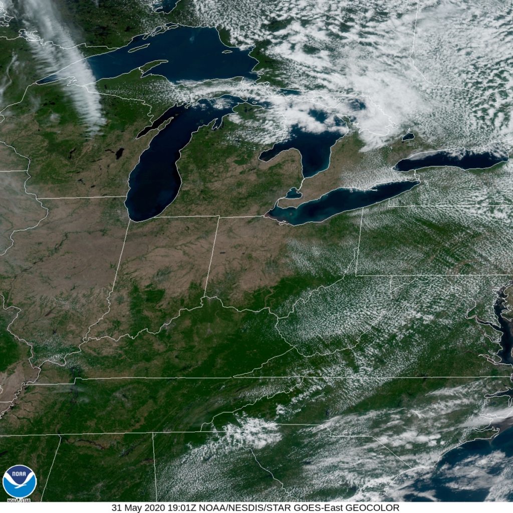
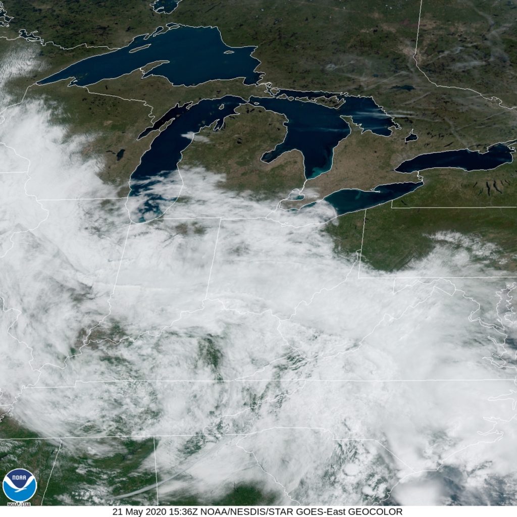
Here is the satellite, showing a very nice end to the weekend across the Great Lakes.

2020 Tropical season off to a flying start

June 1st is recognized at the beginning of hurricane season, and I suppose, if you look at it through that lens, we’re still doing just fine! If you are of the belief that it is the beginning of tropical storm season, then boy, have we jumped the gun.

Every once in a while, and with increasing frequency, the NHC labels a tropical storm, or more typically, a subtropical storm, usually along the Gulf Stream or in the Gulf of Mexico, in May or even April. This is a function of a warmer ocean, but more directly, a relatively recent change in attitude towards naming subtropical storms.

But having two named storms come and go before we even reach June? That’s pretty wild. And there is another storm hanging out in the central Atlantic, with a 50% chance of developing into a tropical feature this weekend.

Both Arthur and Bertha spiraled along the East Coast, with Bertha bringing heavy rain to the Carolinas and New England. If the storm presently in the Atlantic does get named, it would be the first of the true Hurricane Season, and would be named Cristobal.

The storm is expected to wander due north, thanks to a disturbance presently seen on the East Coast, with a chance for a landfall over western Newfoundland early next week. It’s too early to say if this foretells the season to come, but boy, it does seem ominous.

Storms possible in Iowa and the Twin Cities tonight

After several days of severe weather blanketing most of the country, with particular emphasis on the High Plains, the Ozarks and the Carolinas, we are able to focus on just one area in the country, and as luck would have it, it’s the part of the country that I live in.

Low pressure over southern Canada is being undercut by a wave moving north out of Iowa. The nature of this pattern was hard to perceive in the long term by model guidance, and suggests that the nasty weather set up will not be long lived. With all that said, the SPC circled back and posted a slight risk along the Mississippi Valley for today anticipating rough weather.

Given the nature of the system, a big of circulation being drawn towards a deeper area of circulation, the primary threat will be tornadoes, though hail and wind will be a concern as well. The threat for tornadoes has already prompted a watch box in Iowa, which has verified with a confirmed tornado west of Des Moines.

But it’s not just tornadoes that will be a threat. There is a risk that some of the rain fall, particularly in southeastern Minnesota, cold be torrential, and lead to some flash flooding. Below is the WPC heavy rainfall forecast.

As the storm matures, rain will blanket the region, with some regions of stronger updrafts and heavier rain. Here is the HRRR showing the arrival in St. Paul just before 6pm tonight, and looking somewhat ferocious when it arrives.

The heavier rain will continue even after the initial rounds of strong thunderstorms, making for a long, wet night from Des Moines to the Twin Cities.

A bleak start to the weekend

There is a difference between a stormy day and a rainy day, especially on a holiday weekend. If it storms, that means there was probably enough sunlight and warmth during the day to lead to instability. A day with light drizzle throughout just means it was cloudy and gloomy, as it was on Friday in Detroit. There weren’t and reports of rain on Saturday, but it was still cloudy and cool. Fortunately, infrastructural systems that were at their limit already with water didn’t have to withstand too much more precipitation. Forecast.io collected the top forecast for the day.
Actuals: Friday – .06 inches of rain, High 65, Low 59
Saturday – High 72, Low 60

Grade: C

Lawton, Oklahoma to Lancaster, Pennsylvania

After a couple of short trips, we had a very long trip. Now, we can settle somewhere in the middle, with this 2 1/2 day trip. Storm chasing is still a thing even in these strange times, and I could imagine someone having a successful chase based out of Lawton last night, then wanting to take the 1,446 mile journey home to tell stories about the storms they saw near the Red River. The drive will cover 67.5mph and those first two days will be through after about 540 miles on the highway.

DAY ONE (Sunday)

Lawton, Oklahoma

To say the pattern is turbulent in the center of the country is a bit of an understatement. Successive short waves keep spiraling through the northern Plains, which draw moisture and instability through the central and southern Plains. There isn’t so much forcing that I would suggest there might be a severe weather outbreak on Sunday, but I would be surprised if it didn’t rain somewhere along the way. Light rain will be possible around Lawton as we head out, with a break through Oklahoma City and Tulsa, but there will be increasing chances for pop up thunderstorms by the time we hit the afternoon and Missouri. The best threat will be between Springfield and Rolla, but really, they will be aimless, and the possibility will continue to St. Clair, our destination for night one.

DAY TWO (Monday)
The entire Ohio Valley is going to become increasingly humid and warm. There might be a stray pop up shower or thunderstorm virtually anywhere during our drive from St. Clair, but the threat will naturally rise with the temperature as the day progresses. Still, the most active weather will be reorganizing to our west, so I don’t foresee anything more significant than a localized downpour. and the majority of the day will be warm and dry, but perhaps incredibly humid. Our day concludes in Jacksontown, Ohio, which is to the east of Columbus.

DAY THREE (Tuesday)
For the final day of our trip, we have a little bit better news. The low level moisture associated with all the disorganized action in the center of the country will be unable to penetrate Appalachia, and we are right on the doorstep of Appalachia. The threat for some rain likely won’t stretch further east than Zanesville, and the rest of the drive will be beset by nothing other than scenery and mountainside Americana. Lancaster should be appropriately late-springlike.

Lancaster, Pennsylvania

Detroit, Michigan

Michigan had some significant issues with heavy rainfall earlier this week, as dams stressed by the new rainfall failed northwest of Saginaw, near Midland and Edenville, forcing thousands to evacuate. Hopefully, a couple of days of calm quiet weather are on their way, and Michiganders can dry out and put things back together.

At 1053AM, ET, Detroit was reporting a temperature of 65 degrees with mostly cloudy skies. At the surface, things were tranquil with high pressure in the area, but an upper level low churning over Kentucky and Tennessee is smothering the region in clouds and an unusual southeasterly flow across Michigan. A result of this is that warmer temperatures are found north of Detroit, while it gets a bit cooler to the south.
The low is cut off from the primary flow in the region, which is coursing through central Canada. The feature approaching Appalachia will have no direction, save to attempt to drift towards a jet trough in northern Quebec. The circulation in the eastern Midwest won’t drum up much energy in Michigan, but moisture will probably be persistent in the mid and upper levels, suggesting mostly cloudy skies to begin Memorial Day weekend, though the low level moisture shouldn’t be available to lead to much rain, though drizzle will be possible. Expect some dreary times and temperatures not reaching their potential, but certainly not a terrible start to the weekend.
Tomorrow – Mostly cloudy, chance of rain, High 68, Low 56
Saturday – Mostly cloudy, with some drizzle possible, High 74, Low 56

TWC: Tomorrow – Cloudy with occasional showers for the afternoon. High 68, Low 56
Saturday – Intervals of clouds and sunshine. High 76, Low 56

AW: Tomorrow – Mostly cloudy High 67, Low 55
Saturday – Pleasant and warmer with intervals of clouds and sunshine High 75, Low 56

NWS: Tomorrow – Mostly cloudy, High 69, Low 55
Saturday – Partly sunny, High 76, Low 56

WB: Tomorrow – Mostly cloudy, High 66, Low 57
Saturday – Partly cloudy, chance of rain showers in the afternoon, High 75, Low 57

WN: Tomorrow – Mostly cloudy with isolated showers, High 69, Low 55
Saturday – Partly cloudy with isolated storms, High 76, Low 57

FIO: Tomorrow – Possible drizzle in the morning. High 66, Low 55
Saturday – Mostly cloudy throughout the day. High 76, Low 56

My original draft had no precipitation in the Detroit forecast, but then I got cold feet, because they have a local source of moisture just to the east. Still, it’s remarkable to see precipitation forecasts all over the map like this. Should be an interesting verification. Let’s check out this satellite image, with clouds smothering the area just south of Detroit.

Charlottesville, Virginia to Oxnard, California

After a couple of road trips that were merely one day long, we’re hitting the big time, with this 5 day trip across the country. We’ll cover 2,604 miles at a pace of 66.8mph, which means the we will cover 534 miles a day for the first four days of the trek, with the last day being a hair shorter. What a terrific way to get a look at the nation’s weather this week.

DAY ONE (Wednesday)

Charlottesville, Virginia


Wouldn’t it be nice if we got off on the right foot, with clear skies and dry roads to set our pace by. Well, it won’t happen. Low pressure hemmed in by the remnants of Arthur will be raining over the central and southern Appalachians. The heaviest will fall from Roanoke to Knoxville, but lighter rain is going to continue west to Nashville, where we will stop on the eastern fringes of town.

DAY TWO (Thursday)
There isn’t a lot going on specifically over the Mississippi Valley for Tuesday, but it will be enjoying the ramifications of some of the activity elsewhere. Streaks of overcast with drizzle will continue through western Tennessee. After a bit of quiet weather in eastern Arkansas, flow will become southerly in response to another area of low pressure in the Canadian high plains. This may trigger a few thunderstorms from Little Rock west into eastern Oklahoma. We’ll make it to the Robert S Kerr Reservoir, where storm coverage would probably just be increasing through the night.

DAY THREE (Friday)
The showers and storms will probably continue through the night in eastern Oklahoma. If we use a mobile radar app, we’ll see a little bit of gumption would have taken us to Oklahoma City, the night before which will be a lot dryer on Friday. Instead, we’ll drive through a few more showers until we get clear air from western Oklahoma to the Texas Panhandle into New Mexico, where we will stop just past Tucumcari.

DAY FOUR (Saturday)
Finally, after being pushed and pulled by features near and far, things are going to look up as we move through the Desert Southwest. New Mexico and Arizona look to be devoid of any troubling features and even the heat will be pretty manageable. The day will end in Ash Fork, Arizona.

DAY FIVE (Sunday)
Come on. You’ve just spent all this time navigating the country, dealing with scattered showers and thunderstorms, and the monotony of I-40 west of the Mississippi. You deserve to coast to the Coast in Oxnard in peace, and you are going to get it. Enjoy Oxnard.

Oxnard
Oxnard, California

Rochester, New York to Charlottesville, Virginia

We have a long one day drive through the mountains of Appalachia. In the spring time, after a bit of rain, I expect a verdant, gorgeous drive through the Finger Lakes and the Appalachians of Pennsylvania and both varieties of Virginia. We’ll cover about 62 miles per hour until we reach our destination 497 miles away.

Rochester, New York

A fairly amorphous blob of low pressure sits in the Ohio Valley, bringing some serious rainfall just west of the Rockies, however this feature is deteriorating and won’t actually interfere with the first couple of states in our journey. The interesting part, to me anyways, is why the system in the Great Lakes is falling apart. Tropical Storm Arthur, which sits off the mid-Atlantic coast and is cycling in dry air into western New York and Pennsylvania. The precipitation west of the Appalachians will squirt through south of Arthur’s field of influence, and that will lead to some wet roadways as we reach the Hagerstown, Maryland area. Scattered showers and maybe an isolated thunderstorm will be possible for the rest of our drive, but fortunately, much of it is in the shadow of the mountains, and rain won’t be as heavy as it could be, at least not until we turn east from Staunton to Charlottesville. Darn.

Charlottesville, Virginia

A return to spring time

It’s been a rainy week for the mid-Atantic and New England, but for the middle of the week, Barnstable and the Cape saw a bit of of a reprieve. It was cooler than one might expect, but the end of rain and increased sunshine on Wednesday overcame the onshore breezes, and it actually started to warm up, even hitting 60 in the afternoon. That kind of optimism is Victoria-Weather’s wheelhouse, giving us a victory on the day.
Actuals: Tuesday – High 59, Low 41
Wednesday – High 60, Low 36

Grade: B-C