Being wrong, and making it interesting

A thing that I often forget when forecasting in Cleveland, is that their official statistics are measured at Burke Lakefront Airport, and not Cleveland International. This makes a difference! Being by the lakeshore, especially earlier in the year, can keep temperatures cooler than they do further away from the Lake, and I was kicking myself as I came away from the forecast. I should have had lower temperatures! Imagine my surprise when everyone was at least 5 degrees off on the low temperature forecasts on both the 20th and 21st. The scores were all ultimately in the same ball park, so the real separator was Accuweather keeping Cleveland dry for the entire 48 hours, which didn’t seem right to anyone else, but alas, Accuweather blazed their own, victorious trail.
Actuals: May 20th, High 89, Low 72
May 21st, High 86, Low 76

Grade: C-D

Cleveland, Ohio

Cleveland hosted my Minnesota Twins this weekend, and it didn’t go well for Minnesota. I hope it rains in Cleveland.

At 851PM, ET, Cleveland was reporting a temperature of 79 degrees with mostly cloudy skies. A weak surface trough running through southern Ontario was touching off some storms between Toledo and Fort Wayne, but this activity isn’t expected to continue on to Cleveland. There is a more organized complex of storms in the Plains states, but the upper level pattern is not conducive to sustaining this feature either. Expect some cloudy skies on the horizon throughout most of the day, but rainfall will never reach Cleveland on Monday.
An upper level trough moving through the northern Rockies is going to aid in the development and intensification of the next feature, rising out of the Colorado prairies. This feature is expected to be another severe weather maker for the Plains, and through Tuesday, will encourage a warm front to move northward through the Buckeye State. Some scattered showers and storms will be possible over Lake Erie in the afternoon, with some carry over into Cleveland as well.
Tomorrow – Partly cloudy, High 87, Low 64
Tuesday – Partly cloudy with patchy showers possible, High 87, Low 68

TWC: Tomorrow – Intervals of clouds and sunshine. Slight chance of a rain shower High 85, Low 65
Tuesday – Intervals of clouds and sunshine. A stray shower or thunderstorm is possible High 84, Low 71

AW: Tomorrow – Partly sunny and very warm High 84, Low 67
Tuesday – Very warm with times of clouds and sun high 84, Low 70

NWS: Tomorrow – A slight chance of showers and thunderstorms after 3pm. Mostly sunny, High 85, Low 66
Tuesday – A slight chance of showers between 2pm and 5pm, then a slight chance of showers and thunderstorms after 5pm. Mostly sunny, High 86, Low 69

WB: Tomorrow – Partly cloudy. A chance of showers and thunderstorms in the afternoon. High 84, Low 68
Tuesday – Partly cloudy in the morning, then clearing. High 84, Low 70

WN: Tomorrow – Partly cloudy, High 78, Low 67
Tuesday – Partly cloudy with light rain showers, High 81, Low 71

CLI: Tomorrow – Light rain showers, High 82, Low 68
Tuesday – Partly cloudy, High 82, Low 72

The radar is showing some of the activity northwest of town. The forecasts are showing some widely different opinions.

Done in early

I was brave and bold with the forecast for Cleveland. I had no rain in there, and for the predominance of residents in the area, I’m sure they thought that forecast was spot on. But no, a heavy rain storm was in the area for the first hour of the day on Thursday. They had .87″ of rain before 1AM on Thursday, and then it was mostly done for the rest of the week. That counts as a busted forecast for me, and Victoria-Weather fell out of contention. The Weather Channel would have won the day regardless. I’m not sure if that is a consolation or not.
Actuals: Friday: .87″ of rain in thunderstorms, High 81, Low 63
Saturday – High 81, Low 57

Grade: B-C

Cleveland, Tennessee

Cleveland is one of the towns in a busy corridor of eastern Tennessee. It’s closer to Chattanooga than any other town, and nowhere near Lake Erie.

At 150PM, ET, Cleveland was reporting a temperature of 79 degrees with partly cloudy skies. The upper level feature that brought some severe weather to the region yesterday has deteriorated and started spiraling back towards the western Great Lakes. Westerly flow at the south end of the circulation is driving up the Appalachians, and is producing some extra overcast and rain in the region, but at the surface, dry high pressure is pressing in from the southwest.
An upper level trough will shift off the Georgia coast and will aid in the development of a feature in the Gulf of Georgia. It is expected to develop quickly, and is being monitored for tropical development. The focused circulation around this feature is going to clear out the environment on shore for most of the region. Rain will fall in the Coastal Carolinas, but Cleveland will be dry.
Tomorrow – Partly cloudy, High High 78, Low 66
Saturday – Mostly sunny, High 81, Low 60

TWC: Tomorrow – A shower or two around the area in the morning, then partly cloudy in the afternoon. High 80, Low 66
Saturday – Sunshine and clouds mixed. High 81, Low 60

AW: Tomorrow – A passing shower in the morning; otherwise, humid with a blend of sun and clouds High 81, Low 67
Saturday – Mostly sunny and nice High 82, Low 61

NWS: Tomorrow – A slight chance of showers and thunderstorms before 1pm, then a slight chance of showers between 1pm and 2pm, then a slight chance of showers and thunderstorms after 2pm. Patchy fog before 10am. Otherwise, mostly cloudy, then gradually becoming sunny, High 78, Low 64
Saturday – Mostly sunny, High 79, Low 60

WB: Tomorrow – Patchy fog in the morning. Mostly cloudy with a slight chance of sowers and thunderstorms in the morning, then sunny with a chance of showers and thunderstorms in the afternoon. High 78, Low 65
Saturday – Sunny, High 80, Low 60

WN: Tomorrow – Partly cloudy with isolated showers and isolated storms, High 78, Low 64
Saturday – Mostly sunny, High 80, Low 59

FIO: Tomorrow – Rain overnight. High 79, Low 63
Saturday – Partly cloudy throughout the day. High 79, Low 58

I’m going to stay out on my limb, with no rain in the forecast. Right now, rain is moving through the Smokey Mountains, and isn’t backing down the mountains towards Cleveland and Chattanooga. It seems unlikely that that would change, right? Anyways, here is the satellite imagery. There is rain, as I noted, up hill and east of Cleveland. Note the clouds off shore, as that is our pending potentially tropical feature.

Cool mountain air

I admit that perhaps I don’t have a full comprehension of what Cleveland, Tennessee is like, but it seems as though many of our forecasting counterparts are in the same boat. Temperatures overnight, even in the dog days of summer, sure get comfortable! Low temperatures, closer to – and on Thursday lower than – 60 were well off the forecast mark. Showers and storms never reached the region, further bewildering many outlets. Two of the dry forecasters were at the top of the table, with Victoria-Weather following Forecast.io for the win.
Actuals: Thursday, High 91, Low 58
Friday – High 89, Low 60

Grade: C-D

Cleveland, Tennessee

Cleveland is just northeast of Chattanooga, in the well populated stretch of eastern Tennessee that bumps up against North Carolina and Virginia. My goodness, does Tennessee border a lot of states.

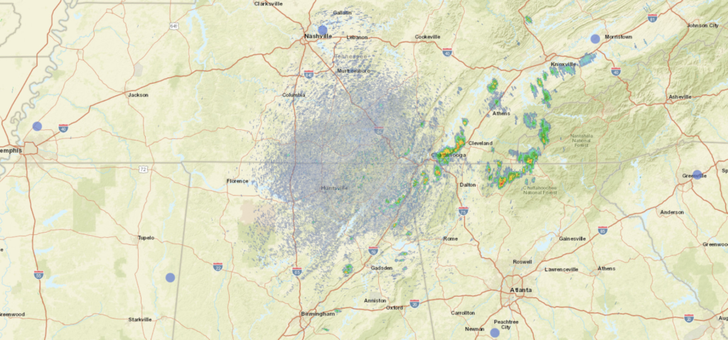
At 105ET, thunderstorms were popping up along I-75, just to the west of Cleveland, though in Chattanooga, thunder and a temperature of 71 degrees with overcast skies. Temperatures across the region where clouds were in place were generally in the low 70s, while sunnier parts of north Georgia had risen to the 80s. Low pressured lingering off the Carolina coast was helping to inspire some extra rainfall at the moment, but will eventually work to pull dry air south.
A dry day is anticipated tomorrow thanks to the machinations on the East Coast, but a sarp trough moving into the center of the country is expected to draw on moisture from the Gulf of Mexico. There won’t be much organization, and it won’t reach the Cleveland area, but by late in the day, expect an increase in clouds and humidity.
Tomorrow – Mostly sunny, High 88, Low 66
Friday – Increasing clouds, High 88, Low 68

TWC: Tomorrow – Sunny along with a few clouds. A stray afternoon thunderstorm is possible. High 86, Low 64
Friday – Overcast. A stray shower or thunderstorm is possible. High 86, Low 65

AW: Tomorrow – Sun and clouds with a passing shower in the afternoon High 86, Low 65
Friday – Mostly cloudy with widely separated thunderstorms High 68, Low 67

NWS: Tomorrow – Sunny, High 85, Low 63
Friday – A 20 percent chance of showers and thunderstorms after 2pm. Partly sunny, High 86, Low 66

WB: Tomorrow – Sunny, High 85, Low 64
Friday – Partly sunny. A slight chance of showers and thunderstorms in the afternoon. High 85, Low 65

WN: Tomorrow – Mostly sunny, High 81, Low 65
Friday – Partly cloudy, High 86, Low 65

FIO: Tomorrow – Clear throughout the day. High 86, Low 61
Friday – Mostly cloudy throughout the day. High 86, Low 65

It’s probably going to be a bit warm and sticky, but really for early August this is pretty comfortable. See the radar, with rain in Chattanooga, below.

Cleveland, Ohio

Tonight we head to the Great Lakes where we visit a city that is the site of my favorite sporting moment in my life so far… the Cubs winning the World Series! Sorry Cleveland, but you had already won the NBA title that year.

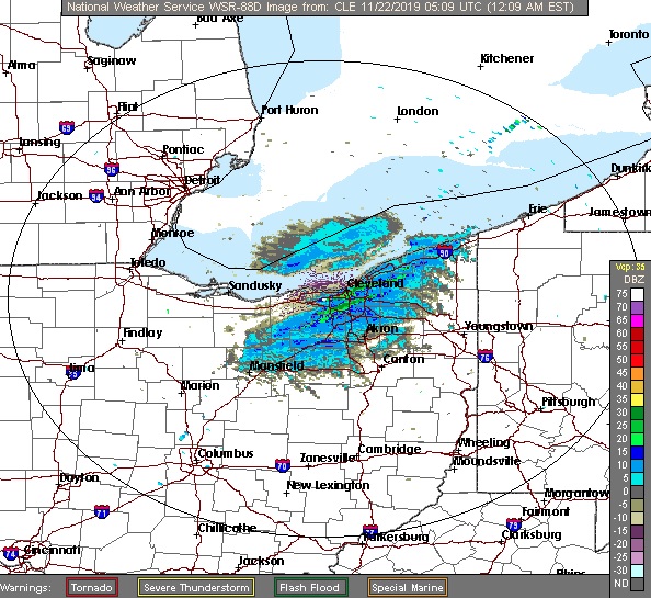
At 1153pm EST, the temperature in Cleveland, OH was 51 degrees with some light rain occurring. A cold front is pushing through the Great Lakes tonight with some light rain showers pushing through the Cleveland area. These showers will persist into the pre-dawn hours before shifting eastward. Dry weather and decreasing clouds will seem more pleasant for the daytime hours, but a breezy northwest wind will continue to usher in colder air throughout the day, leading to a midnight high and only a daytime high in the upper 30s. Weak high pressure will traverse the area Friday evening into Saturday morning with mostly clear skies. However, this will be short-lived as a low-pressure system develops over the Lower MS-River Valley and shifts northeastward. While the bulk of the system will miss off to the east, some rain showers on the northwestern side of the low look to wraparound and impact the city on Saturday evening. Nothing too heavy, just enough to annoy every that’s out having fun on their weekend.

Friday: A few early morning showers, decreasing afternoon clouds with temperatures dropping. High 51, Low 32.
Saturday: Increasing clouds, a couple late evening showers possible. High 45, Low 29.

TWC: Friday: Early rain, then partly cloudy/windy. High 43, Low 35.
Saturday: Afternoon showers. High 45, Low 30.

AW: Friday: Some sun returning; cooler. High 52, Low 35.
Saturday: Occasional afternoon rain. High 44, Low 30.

NWS: Friday: A few early morning showers, then breezy and mostly sunny. High 41, Low 33.
Saturday: Partly sunny, chance of rain. High 46, Low 30.

WB: Friday: Chance of early morning rain, then partly cloudy. High 52, Low 33.
Saturday: Chance of rain. High 44, Low 31.

WN: Friday: Slight chance of morning shower, then partly cloudy. High 53, Low 33.
Saturday: Partly cloudy with scattered showers. High 46, Low 31.

FIO: Friday: Drizzle tonight. High 52, Low 32.
Saturday: Mostly cloudy throughout the day. High 45, Low 28.

A few rain showers are traversing the region currently, but the rest of the day should be dry!