Kalamazoo, Michigan

Our trek today takes us to the Lower Peninsula of Michigan, and certainly one of the more enjoyably named cities in the country.

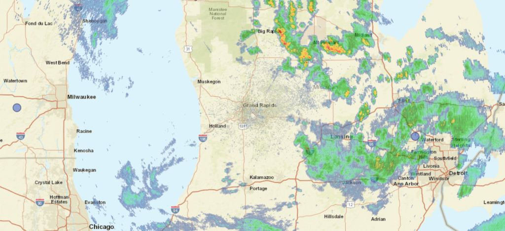
At 453PM, ET, Kalamazoo was reporting a temperature of 65 degrees with overcast skies. A sharp trough directed from the Great Lakes to the Mid Atlantic has brought severe weather to the Ohio Valley yesterday, but is now providing intermittent shower activity across Lower Michigan. At this juncture, most of the rain is east of a line from Big Rapids and Marshall, with lighter activity in the western stretch of the state.
The low is continuing eastward, but is occluded similar to a more winter or springlike feature, leading to a lag in the shower activity over Michigan. A chance will linger in Michigan until about lunch time tomorrow, but high pressure and a narrow ridge are building behind the feature. Temperatures will bounce back after this chilly start. The jet will begin to break down, weakening from it’s current state, and as a result, humidity and clouds are going to remain in the forecast.
Tomorrow – Cloudy with some light showers in the morning, Clearing late, High 78, Low 57
Wednesday – Partly cloudy and warmer, High 83, Low 54

TWC: Tomorrow – Cloudy skies early, then partly cloudy in the afternoon. A stray shower or thunderstorm is possible. High 77, Low 60
Wednesday – Partly cloudy. High 84, Low 53

AW: Tomorrow – Cloudy and warmer with a passing shower; smoke from distant wildfires can cause poor air quality High 77, Low 60
Wednesday – Mostly sunny, pleasant and warmer High 85, Low 56

NWS: Tomorrow – A 30 percent chance of showers before 8am. Widespread haze before noon, then widespread haze after 2pm. Cloudy, then gradually becoming mostly sunny High 77, low 59
Wednesday – Sunny, High 84, Low 53

WB: Tomorrow – Cloudy with a chance of showers and a slight chance of thunderstorms High 78, Low 60
Wednesday – Mostly cloudy with a 20 percent chance of rain showers until midday, High 83, Low 54

WN: Tomorrow – Hazy, High 77, Low 59
Wednesday – Hazy, High 83, Low 53

CLI: Tomorrow – Overcast (Light rain), High 81, Low 57
Wednesday – Sunny, High 84, Low 54

Radar is deceptively inactive. Don’t be surprised in Western Michigan by random little spritzes of rain this evening.

Coming soon…

The weeks ahead are going to be hot, and if they are anything like the last few days, fairly active as well. We’re going to dot the country with a variety of forecasts for your viewing enjoyment in the coming weeks.

Odessa, Texas

Denver, Colorado

Harrisonburg, Virginia

Road Trip from Harrisonburg to Oklahoma City, Oklahoma

Louisville, Kentucky

Cumberland, Virginia
Road Trip from Louisville – Cumberland

Orlando, Florida

May Forecaster of the Month

If ever there are months that you want some forecasting consistency, they are the spring time months. Every forecast we had in the month had a combined winner, which suggests that we got that in May. Still, Accuweather was a hair better than the rest, and were able to attain the title of Forecaster of the Month for themselves.

OutletForecast Wins (year)
Victoria-Weather3
Clime2.5
National Weather Service2.5
Weatherbug1
The Weather Channel1
WeatherNation0.5
Accuweather0.5

Omega in charge

This month has been quite rainy for the southern US, but for a strip from the north central to the mid-Atlantic, it has been quite dry for a couple of weeks. It all started with an omega block, which we identified with our forecast in Allentown. Allentown remained dry, despite some storms in the area on the 6th of June, and it was quickly followed by the apocalyptic smoke that descended on the region. A little rain on any number of tracts of land between northern Canada and Allentown would have been great, but it was not to be. Victoria-Weather’s forecast sparkled, and the victory was ours.
Actuals: June 5th, High 77, Low 48
June 6th, High 79, Low 52

Grade B-C

Fort Myers, Florida

Fort Myers was the scene of one of the biggest weather disasters of 2022, when Hurricane Ian made landfall nearby. I have family in the area and was there over Christmas, and can speak to the long recovery the area is still struggling to undergo.

At 353PM, ET, Fort Myers was reporting a temperature of 89 with fair skies. A jet over south Florida was leading to persistent rain showers from the Everglades northeast towards the Atlantic Coast. At this point, heavier, isolated thunderstorm cells had crept up from Lake Okeechobee to Everglades City and eastward to the Atlantic. This band of showers and storms is associated with a cold front that itself is associated with the area of low pressure in New England that is cycling in an overwhelming amount of smoke to the mid-Atlantic.
The tail of this jet will shift towards the Bahamas eventually, with the threat for rain not truly out of the forecast in Fort Myers until Saturday. The trough in the mid-Atlantic is going to be even slower to drive out, with flow in the area not shifting to become less northerly until Sunday. as a result, relief from the smoke may have to wait until late in the weekend. Expect streams of clouds to continue to bubble up over far south Florida through the next couple of days, though Fort Myers will avoid any more of the thunderstorm activity, with sea breeze storms becoming prevalent inland.
Tomorrow – Partly cloudy and warm, High 91, Low 72
Sunday – Partly cloudy, High 91, Low 74

TWC: Tomorrow – Sunny, along with a few afternoon clouds. A stray shower or thunderstorm is possible. High 90, Low 73
Sunday – Except for a few afternoon clouds, mainly sunny. A stray shower or thunderstorm is possible. High 91, Low 73

AW: Tomorrow – Partly sunny with a thunderstorm in parts of the area in the afternoon High 91, Low 73
Sunday – Except for a few afternoon clouds, mainly sunny. A stray shower or thunderstorm is possible. High 92, Low 74

NWS: Tomorrow -Scattered showers and thunderstorms after 2pm. Sunny, High 89, Low 74
Sunday – Scattered showers and thunderstorms after 2pm. Sunny, High 90, Low 74

WB: Tomorrow – Sunny. Scattered showers with isolated thunderstorms in the afternoon, High 89, Low 75
Sunday – Sunny, Scattered showers with isolated thunderstorms in the afternoon, High 90, Low 75

WN: Tomorrow – Partly cloudy with scattered showers and isolated thunderstorms, High 88, Loe 75
Sunday – Partly cloudy with scattered showers and isolated thunderstorms, High 89, Low 75

CLI: Tomorrow – Light rain showers, High 91, Low 74
Sunday – Light rain showers, High 90, Low 75

I’m leaving rain out of the forecast because it seems like storms are expected to pop up further inland. I know, I know, always have thunderstorms in a Florida forecast. I’m sure I will learn a lesson. Radar is active so far this morning.

Charlotte, North Carolina to Allentown, Pennsylvania

Charlotte and Allentown are definitely Eastern cities, but they have the good fortune of not being along the Coast. This means that our route can take I-81, which is windier, hillier and otherwise more scenic, while also avoiding the traffic of I-95. It will take a day to get from North Carolina to our destination in Pennsylvania, at a pace of 66.4mph.

Charlotte, North Carolina

There are a few clouds streaming across the Coastal Plains as low pressure churns off the coast of New England. The low will drift to Nova Scotia, while breezier and relatively cool air continues to press south. The flow will be coming up an over the Appalachians, so relative to the conditions throughout the rest of Vieginia, expect clearer skies. As we pass west of Baltimore, we will get north of the front, which will shear away the remaining threat of wet weather. Allentown will be delightful and awaits our arrival.

Allentown, Pennsylvania

Allentown, Pennsylvania

I know some people that live in Allentown, and they commute to New York City at times if they need to go in the office. Can you imagine, potentially going through three states in a day just to get to work? We’re only going to be looking at Allentown though, and limit our scope to just the one state.

AT 1051PM, ET, Allentown was reporting clear skies and a temperature of 54 degrees. Clear skies are seen across the region. Allentown is at te eastern flank of an Omega Block across the middle of the country. Low pressure developing on the eastern flank of the features is rising north along the Coast, while a weak cool front off the tail of the system has recently passed Allentown, making life a bit more tolerable after a hot weekend.
As is often the case with blocking patterns, don’t expect much change over the next couple of days. Low pressure will retrograde into Nova Scotia, and the boundary will stall. At varying instances, there may be some additional clouds, and some stronger north breeze. A light shower may crop up on Tuesday.
Tomorrow – Partly cloudy, High 76, Low 48
Tuesday – Partly cloudy with a chance for light rain, High 80, Low 52

TWC: Tomorrow – Sunshine and clouds mixed. High 78, Low 47
Tuesday – Mostly sunny skies. High 78, Low 53

AW: Tomorrow – Intervals of clouds and sunshine High 77, Low 50
Tuesday – Partly sunny with a brief shower; smoke from distant wildfires can cause hazy skies and poor air quality High 77, Low 55

NWS: Tomorrow – Increasing clouds High 78, Low 48
Tuesday – A slight chance of showers, then a chance of showers and thunderstorms after 2pm. Sunny, High 78, Low 55

WB: Tomorrow – Sunny in the morning, then becoming partly sunny, High 77, Low 48
Tuesday – Mostly sunny. A chance of showers in the afternoon. High 77, Low 53

WN: Tomorrow – Partly cloudy, High 78, Low 49
Tuesday – Partly cloudy with isolated showers and storms, High 79, Low 54

CLI: Tomorrow – Mostly cloudy, High 75, Low 46
Tuesday – Light rain showers, High 75, Low 52

It’s pretty warm in the middle of the country, and it was this weekend in Allentown. What a terrific break this weather will be.

nto