
Fort Myers was the scene of one of the biggest weather disasters of 2022, when Hurricane Ian made landfall nearby. I have family in the area and was there over Christmas, and can speak to the long recovery the area is still struggling to undergo.
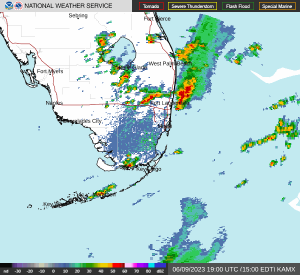
At 353PM, ET, Fort Myers was reporting a temperature of 89 with fair skies. A jet over south Florida was leading to persistent rain showers from the Everglades northeast towards the Atlantic Coast. At this point, heavier, isolated thunderstorm cells had crept up from Lake Okeechobee to Everglades City and eastward to the Atlantic. This band of showers and storms is associated with a cold front that itself is associated with the area of low pressure in New England that is cycling in an overwhelming amount of smoke to the mid-Atlantic.
The tail of this jet will shift towards the Bahamas eventually, with the threat for rain not truly out of the forecast in Fort Myers until Saturday. The trough in the mid-Atlantic is going to be even slower to drive out, with flow in the area not shifting to become less northerly until Sunday. as a result, relief from the smoke may have to wait until late in the weekend. Expect streams of clouds to continue to bubble up over far south Florida through the next couple of days, though Fort Myers will avoid any more of the thunderstorm activity, with sea breeze storms becoming prevalent inland.
Tomorrow – Partly cloudy and warm, High 91, Low 72
Sunday – Partly cloudy, High 91, Low 74
TWC: Tomorrow – Sunny, along with a few afternoon clouds. A stray shower or thunderstorm is possible. High 90, Low 73
Sunday – Except for a few afternoon clouds, mainly sunny. A stray shower or thunderstorm is possible. High 91, Low 73
AW: Tomorrow – Partly sunny with a thunderstorm in parts of the area in the afternoon High 91, Low 73
Sunday – Except for a few afternoon clouds, mainly sunny. A stray shower or thunderstorm is possible. High 92, Low 74
NWS: Tomorrow -Scattered showers and thunderstorms after 2pm. Sunny, High 89, Low 74
Sunday – Scattered showers and thunderstorms after 2pm. Sunny, High 90, Low 74
WB: Tomorrow – Sunny. Scattered showers with isolated thunderstorms in the afternoon, High 89, Low 75
Sunday – Sunny, Scattered showers with isolated thunderstorms in the afternoon, High 90, Low 75
WN: Tomorrow – Partly cloudy with scattered showers and isolated thunderstorms, High 88, Loe 75
Sunday – Partly cloudy with scattered showers and isolated thunderstorms, High 89, Low 75
CLI: Tomorrow – Light rain showers, High 91, Low 74
Sunday – Light rain showers, High 90, Low 75
I’m leaving rain out of the forecast because it seems like storms are expected to pop up further inland. I know, I know, always have thunderstorms in a Florida forecast. I’m sure I will learn a lesson. Radar is active so far this morning.
Comment (1)