As we discussed, temperatures are staying cool for a lot of the eastern part of the country, and it seems as though we will be hunting warm air, if we can find it.
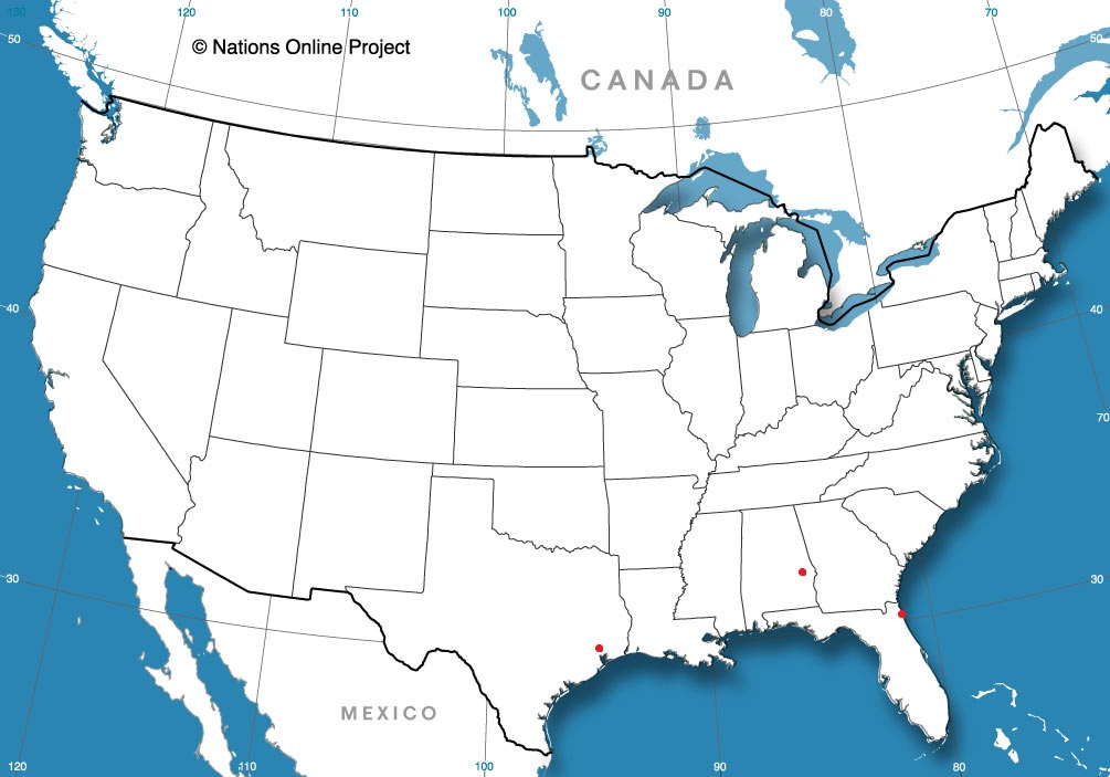
Anniston, Alabama
Jacksonville, Florida
Houston, Texas
from Victoria-Weather

As we discussed, temperatures are staying cool for a lot of the eastern part of the country, and it seems as though we will be hunting warm air, if we can find it.
Anniston, Alabama
Jacksonville, Florida
Houston, Texas
The CPC has issued their outlook, as of yesterday, for the 6-10 day, 8-14 day and 3-4 week outlooks. This is the 6-10 day outlook, but I assure you, the other two vary only slightly.
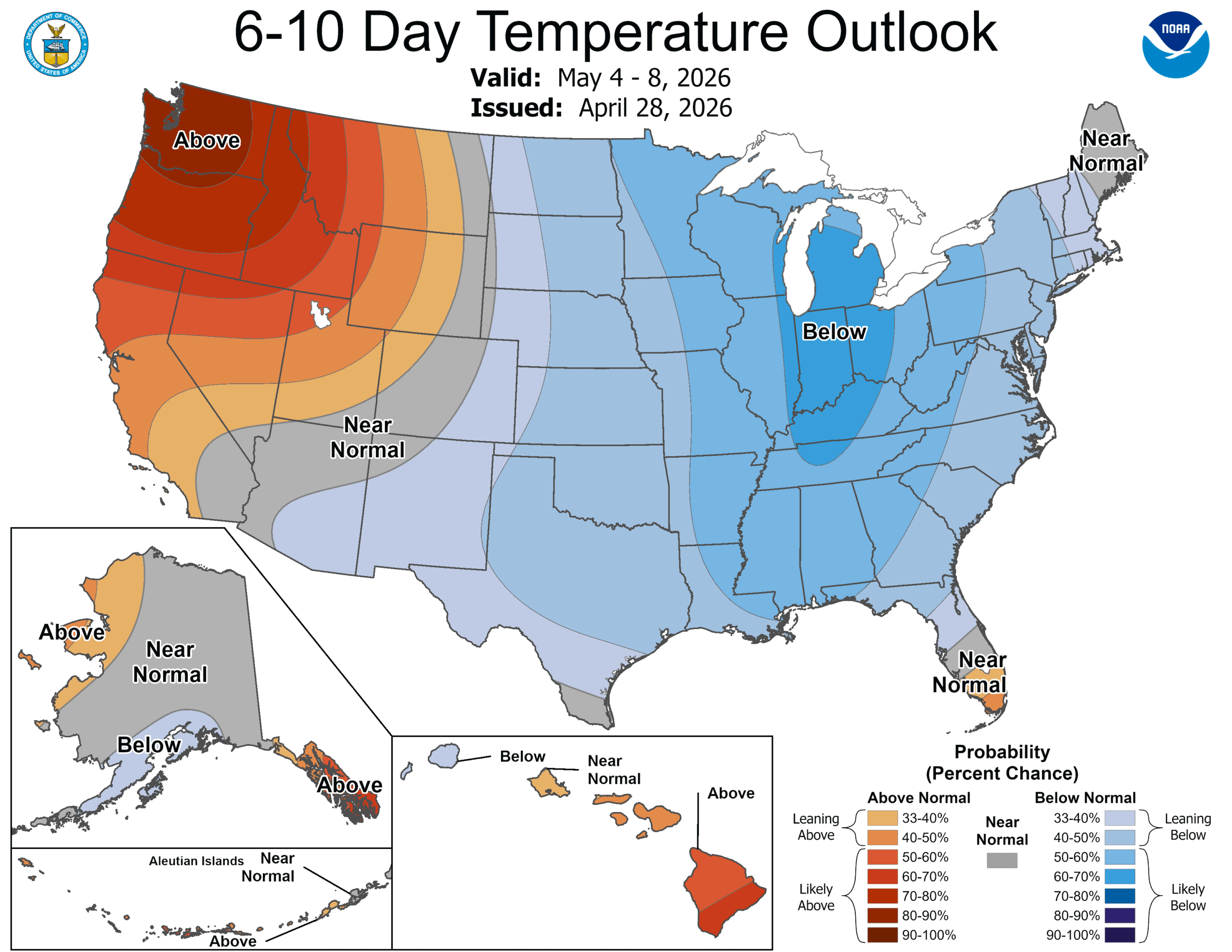
The jet flow is going to be bifurcated throughout the next couple weeks, with a strong jet running along the northern Gulf Coast. The Polar jet will be wavering along the Canadian border, often dipping into the US as a trough, ensuring some active weather, however the jet streak to the south will be an effective barrier to moisture rising into the continental US. We aren’t anticipating many soakers around the Great Lakes. This will do wonders for the drought in the southeast, though.
Even with successive waves from the northern jet, it’s really just seasonal thermal forcing that is going to break down the feature to the south and start allowing warmth and moisture back to the north. This isn’t expected to happen until around the 11th, though, which is why we have such a lengthy stretch of below normal temperatures East of the Rockies. It’s still nearly two weeks out, but the action of the northern jet by the 11th tells me that it won’t suddenly get hot in the northern tier, with ongoing showers and storms remaining likely, which will keep temperatures a little cooler if the showers are too widespread
If you are a fan of warm weather, this forecast is a bummer. If you are a storm chaser, this is also a bummer, as this should put a damper on what is historically one of the most active storm periods on the calendar. If you live on the West Coast, you can ignore everything above and enjoy the beach.
Our forecast for Brownsville was for hot, humid days over the weekend, which was expected to lead to some morning fog, especially on the coast. Brownsville is further inland, but even there, the atmospheric moisture was so thick that the condensate was registered as .01″ of precipitation on Saturday. It was still plenty hot and plenty humid in the afternoon when the fog was burned off. There was a three way tie among our most unexpected trio: WeatherNation, WeatherBug and Clime.
Actuals: Saturday: .01″ of precipitation, High 88, Low 75
Sunday – High 90, Low 78
Grade: B
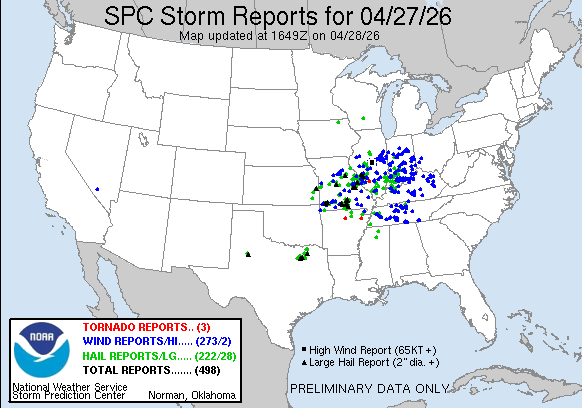
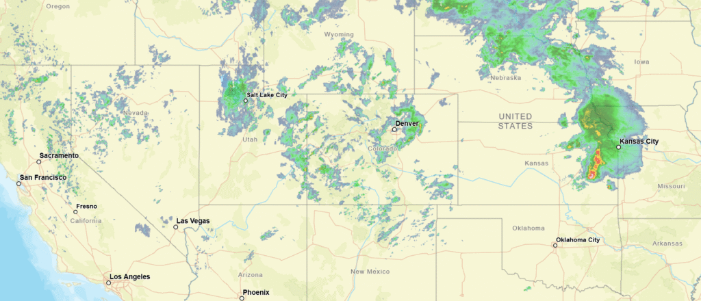
Just after sunrise on April 27th, the SPC elevated the thunderstorm forecast for southeastern Missouri to a moderate risk. A deep upper level trough was generating a strong area of low pressure in the Plains that was feasting on the chaos of colliding air masses. Cold and Canadian with tropical and maritime. The helicity in the atmosphere meant tornadoes were likely.
There were indeed several tornadoes from Missouri to Indiana, with a great deal of damage wrought by straight line winds. The tornadoes were embedded within a line, and at some point, it becomes a bit academic as to whether damage is caused by winds or tornadoes.
The changes to the SPC and the deeper set of information within the convective outlook are new features to the thunderstorm season. I wanted to take this specific example to look at what the SPC released, and see what factors best correlate to the outlook that is provided. First, here is the outlook, issued in the early hours on Monday.
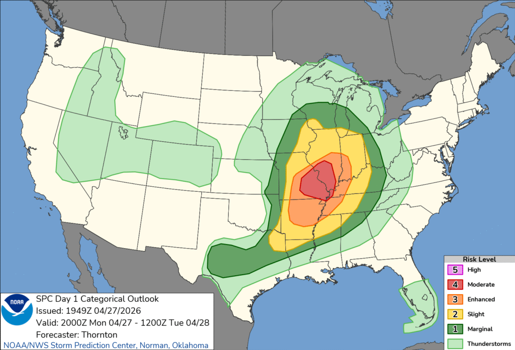
As a bit of background, the change that was recently made to the storm hazard maps added a storm intensity rubric to go along with the probability guidelines that had been a part of those maps before. Take a look at the wind and hail maps to get the idea.
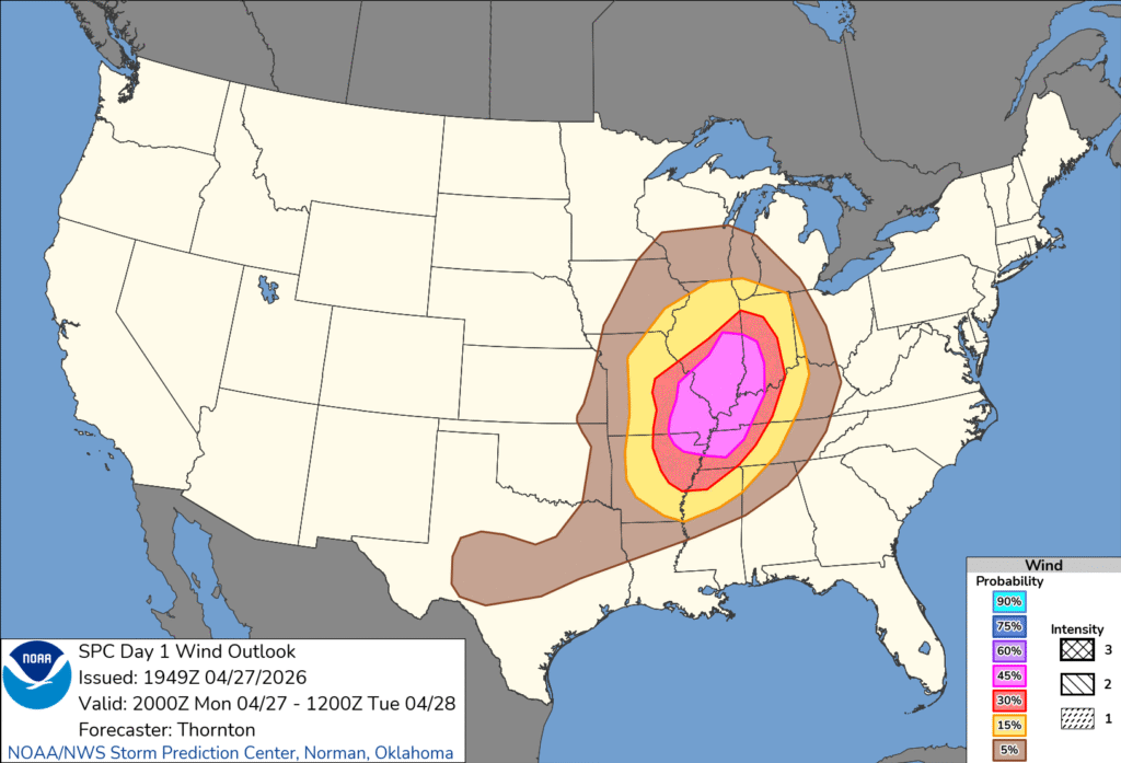
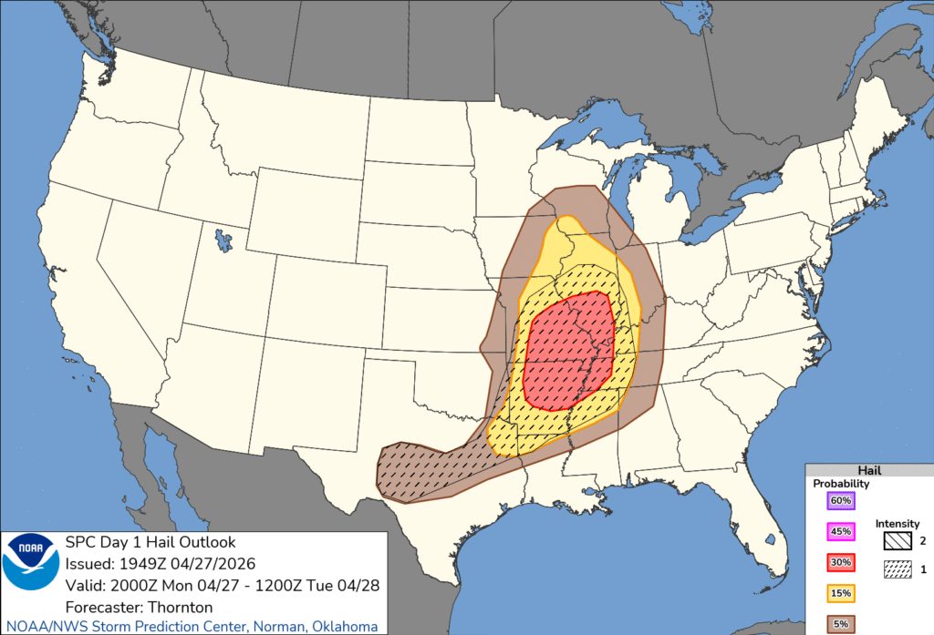
So, you can see there was a high probability of strong wind, and a lower probability of hail, but the hail in the forecast was expected to be larger. We can also see that neither the high probability of severe wind, or the expectation of large hail defined the moderate outlook boundaries. That’s not particularly surprising. That the significant hail in central Texas didn’t lead to a higher outlook than a marginal risk in central Texas surprised me, though.
Moderate and high risk events generally need a threat of tornadoes, so let’s look at the tornado outlook issued at the same time as the full outlook.
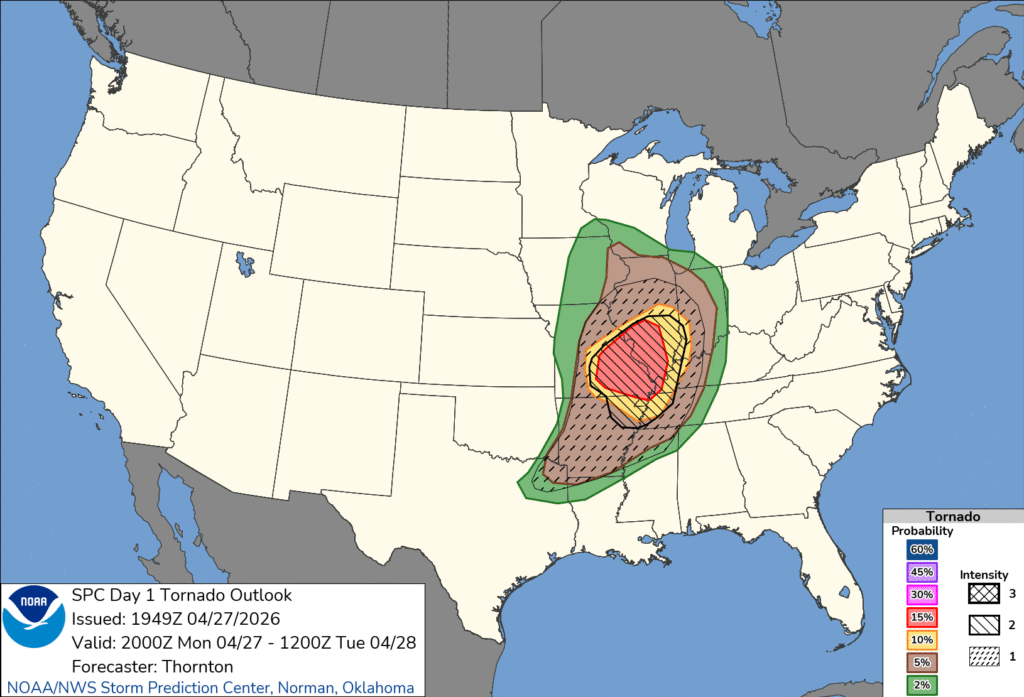
The threat for strong tornadoes is only designated on the charts as 1, 2 or 3, and the probability of a tornado within 25 miles of a spot is more well defined. Perhaps it is no surprise, then, that the moderate hugs the 15% chance of a tornado risk. I’m sure it didn’t hurt the case that the forecast was a level 2 on the intensity scale, either.
For what it’s worth, here is the break down of severe reports.
This is a cool trip, with a route through the mountains. lasting three days and covering 1,671 miles. That breaks down to about 66.8mph, and two days of 534.7 miles, with a longer day at the end. It’s going to be pretty scenic, I think!
DAY ONE (Monday)

As you may have heard, there is severe weather in the Plains tonight. It will be more widespread and significant tomorrow as the low shifts to the Mississippi Valley. A cold front is expected to dangle off the southwestern flank of the feature, with strong thunderstorms possible. There is significant disagreement in the models as to whether storms will fire along this front as far west as our route, but if they do intercept, it will be around Eden, Texas. We won’t escape the state by the end of the day, rounding out the day in Forsan, near Big Springs.
DAY TWO (Tuesday)
The drive on Tuesday will be through the back roads of west Texas and New Mexico, including a pretty good cross section of Albuquerque. The big area of low pressure will be transitioning well away from the middle of the country by midweek, so the drive will ultimately be partly cloudy, with a bunch of scenery to enjoy. We’ll reach Counselor, New Mexico, halfway to Farmington.
DAY THREE (Wednesday)
Soak this day in. We’re going to trek through some of the most beautiful country the nation has to offer. We’ll run past several national parks, Moab and other tracts that aren’t federally protected, but still attractive. The weather will cooperate, with overcast coming back into the picture between Salt Lake and Logan. It will be one of the more exemplary drives we’ve taken, and the weather will generally be pretty great, too.
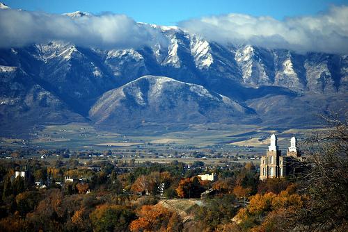
We are headed to the Utah Panhandle for our forecast today. Have you ever been?
At 151PM, MT, Logan was reporting light rain, and a temperature of 43 degrees. A deep trough aloft has helped generate a strong area of cyclonic flow centered over northern New Mexico. Scattered showers are widespread across the Central Rockies, with snow common at elevation. Logan is on the back side of the feature, and is enduring the cooler wet weather.
Despite the surface feature intensifying and shifting towards the Great Lakes, moisture will remain strewn through the Rockies, riding the northern flank of the jet. Spots of rain will be in the forecast through the day tomorrow but ultimately, the vigorous jet is the culprit, and will carry most of the moisture at altitude. Rain and snow will thin vertically, and Tuesday morning will be dry in Logan, but not in the Wasatch.
Tomorrow – Mostly cloudy, scattered showers, High 51, Low 35
Tuesday – Partly cloudy, clearing, High 56, Low 32
TWC: Tomorrow – Overcast. High 52, Low 33
Tuesday – Intervals of clouds and sunshine in the morning with more clouds for later in the day High 55, Low 31
AW: Tomorrow – Cool with intervals of clouds and sun; widely separated afternoon thundershowers High 52, Low 33
Tuesday -A shower in the area in the morning; otherwise, mostly cloudy High 55, Low 34
NWS: Tomorrow -Rain showers likely before 9am, then rain and snow showers likely between 9am and noon, then rain showers likely after noon. Some thunder is also possible. Mostly cloudy, High 52, Low33
Tuesday – A chance of showers, with thunderstorms also possible after noon. Partly sunny High 56, Low 32
WB: Tomorrow -Snow showers in the morning then snow showers rain showers and a slight chance of thunderstorms in the afternoon. Mostly cloudy. Accumulation 1 inch High 43, Low 33
Tuesday -A chance of snow showers and a slight chance of thunderstorms in the morning then a chance of snow showers rain showers and a slight chance of thunderstorms in the afternoon High 47, Low 33
WN: Tomorrow – Mostly cloudy with a light wintry mix and isolated storms. High 52, Low 33
Tuesday – Partly cloudy with scattered showers and isolated storms, High 56, Low 32
CLI: Tomorrow – Heavy snow showers High 50, Low 32
Tuesday – Light rain showers High 53, Low 31
There is some variability on the end time for precipitation. I feel as though the position at the var northern end of Utah will isolate Logan a bit from the steering flow and dry them out a bit. Only one way to find out. It is quite wet tonight, however.
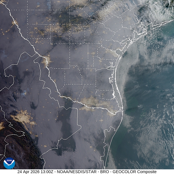
We are headed to the Rio Grande for our forecast tonight. It’s been a while since we have issued a forecast for Texas, and today, we are going as far south into Texas as we can get.
At 953PM, CT, Brownsville was reporting a temperature of 81 degrees with cloudy skies. The air was soupy, with dew points in the mid-70s. It is getting deep enough into the spring that the course of the jet has lifted to the north. Flow is through the the Gulf and into low pressure in the Canadian Prairie, giving rise to the local humidity.
A deeper trough is going to develop over the Desert Southwest before rotating north into the Central Plains. A cold front will drape through the Plains, and present a severe threat for the Ozarks, in particular, however for interests around Brownsville, it will mean continued warmth and humidity, with clouds early, and some coastal fog.
Tomorrow – Mostly cloudy, High 91, Low 75
Sunday – Mostly Cloudy, High 94, Low 75
TWC: Tomorrow – Cloudy early with partial sunshine expected late. Areas of patchy fog. High 89, Low 76
Sunday – Mostly cloudy skies early, then partly cloudy in the afternoon. Areas of patchy fog. High 90, Low 76
AW: Tomorrow – Mostly cloudy and humid High 90, Low 76
Sunday – Humid with clouds and sun; breezy in the afternoon High 91, Low 77
NWS: Tomorrow – Partly sunny High 90, Low 77
Sunday – Mostly cloudy, then gradually becoming sunny High 91, Low 75
WB: Tomorrow – Mostly cloudy in the morning then becoming mostly sunny High 89, Low 75
Sunday – Mostly sunny High 90. Low 76
WN: Tomorrow – Partly Cloudy, High 88, Low 76
Sunday – Partly cloudy, High 90, Low 76
CLI: Tomorrow – Partly cloudy High 89, Low 75
Sunday – Partly cloudy High 90, Low 76
Oof. Does anyone have a lemonade? Cloudy skies in the South Texas morning.
Our journey this week takes us on a route that will certainly be easy on the traffic. We’ll head northwest over the course of two days, covering 1192 miles That second day will be our longer of the two, with a pace of 67.5mph. Our second day will be longer – and it will feel like it – with day one concluding after 540 miles.
DAY ONE (Tuesday)
Day one will be the day with actual human population along our route. We’ll pass through Kansas City, Omaha and Sioux Falls without much of an interruption. Temperatures will be nice and toasty along the way, and I will give you permission to leave windows cracked as we proceed. The day will end as we reach Montrose, South Dakota, not far to the west of Sioux Falls.
DAY TWO (Wednesday)
A pretty deep area of low pressure is going to develop midweek in the northern Rockies. It’s going to churn even more warm air and a bit of humidity. This is likely to play out with some thunderstorms developing late in the day. I would say there will be some storms in the Black Hills of South Dakota as we navigate through, with more isolated storms in southeastern Montana. Don’t be surprised if there is rain in Billings tomorrow evening, but don’t necessarily expect it, either. So what is there to do in Billings, anyway?
It was forecast to be quite warm last week in Fayetteville. Make no mistake, it was quite warm, but there were several degrees between what occurred and what still stands as records for the 14th and 15th of April. Accuweather in particular was feeling strongly that there was a chance for record temperatures, but the numbers skewed towards the lower forecast values. The top forecast belonged right here, at Victoria-Weather.
Actuals: Tuesday – High 86, Low 59
Wednesday – High 90, Low 61
Grade B
We’re heading for a long drive on Friday. It will take 6 1/2 hours to cover 421 miles, which settles in at about 64.7mph, slowed mostly by St. Louis. Let’s cross two of America’s grandest rivers (and get pretty darn close to a third) in one day.

Our first bridge to cross will be over the Ohio and into Indiana, before we turn westward. The Mississippi Valley will be quiet for once, with warm, increasingly humid air for our route. So hot and humid, in fact, that there is a chance of some isolated pop up shower and storm activity early in the day. Low pressure in the Plains is going to drive that summerlike air north, and as we get west of St. Louis and the Mississippi, we will start to see more ominous clouds to the northwest, with the shower threat diminishing directly over our route. A very strong and active cold front will be congealing in northwest Missouri, and will arrive in Springfield that evening. After us, though, so we can sit and anticipate it’s arrival.