It gets hot and stays hot in the central valleys of California, but when you are butted up against the coast, on the west side of the Coastal Range, and without a corridor of wind form the Great Basin, it stays fairly cool, with clouds and sometimes, but not in the case of San Luis Obispo, a stray shower within the fog. Like I said, it was dry, and quite comfortable for our forecast at the end of July into the beginning of August. The Weather Service and WeatherNation drew level for the forecast, and anyone who strayed too far from the mid-70s ended up looking foolish. Actuals: July 31st, High 75, Low 56 August 1st, High 73, Low 54
We are on our way to Point Conception, north of LA for this forecast. There were tsunami advisories south of SLO today, which is not something I have seen on an NWS alert map in the past.
At 656PM, PT, San Luis Obispo was reporting clear skies and a temperature of 64 degrees. There was a brisk onshore flow, keeping things comfortable west of the Coastal Range, though it was in the mid-90s on the other side of the mountains. There is a jet streak over central California ensuring onshore flow will be maintained with some vigor, however of greater note is the low clouds lurking offshore. Point Conception is prime territory for morning low clouds and fog, and each of the next to days should feel the impact of the Marine Layer. Tomorrow – morning clouds and fog, High 76, Low 55 Friday – Morning clouds, clearing, High 76, Low 55
TWC: Tomorrow – Partly cloudy skies High 74, Low 54 Friday – Sunshine along with some cloudy intervals. High 75, Low 56
AW: Tomorrow – Clouds giving way to sun High 77, Low 56 Friday – Mostly sunny and nice High 78, Lo 56
NWS: Tomorrow – Patchy fog before 11am. Otherwise, cloudy through mid morning, then gradual clearing, High 75, Low 55 Friday – Patchy fog before 11am. Otherwise, cloudy through mid morning, then gradual clearing High 76, Low 55
WB: Tomorrow – Low clouds and fog in the morning then sunny. High 81, Low 58 Friday – Low clouds and fog in the morning then sunny. High 80, Low 59
WN: Tomorrow – Partly cloudy, High 75, Low 55 Friday – Partly Cloudy, High 76, Low 55
CLI: Tomorrow – Sunny, High 74, Low 56 Friday – Sunny, High 74, Low 58
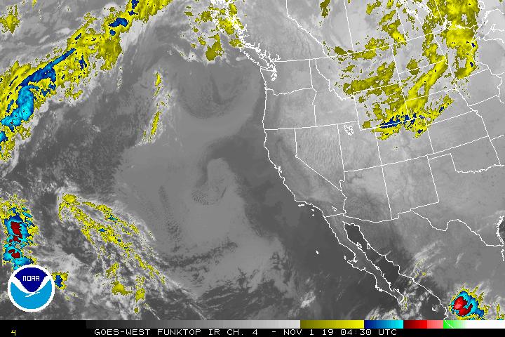
Wow, one degree different from the NWS forecast. We’ll all feel pretty silly if we are a ways off. Satellite shows the lingering clouds offshore.
The weather in California is pretty reliable. It’s often warm, sometimes hot, with a lot of sun, and some splashes of rain. When winter rolls around, interior California gets huge amounts of snow, which later water the Central Valley with the melt in the summer. But then, when things go off kilter, you get killer heat waves and fires, or rain that falls nearer the coast and causes flash flooding and land slides. We had a forecast for San Luis Obispo last month and I’m happy to say that the nastiest it got was some morning fog, which was quickly scoured out with a steady morning breeze. Accuweather had the top forecast, which had some temperature error thanks to a chilly morning low, but ultimately everyone is glad for a couple of nice days where the only complaint might be a few minutes of fog. Actuals: February 24th, High 73, Low 45 February 25th, High 77, Low 54
What are you doing this week? How about a 5 day trip to the West Coast? The drive covers 2,760 miles, which will lend itself to a pace of 67mph, and about 539 miles a day. I-40 is calling your name!
DAY ONE (Monday)
Harrisburg, Pennsylvania
The first day of our journey offers good omens. Sunny skies and above average temperatures await Monday in the Ohio Valley. There will be a bit of a northwest flow off the Lakes but it won’t be cold enough for a good Lake effect fetch. Just enjoy the scenery, and end the day in Indianapolis. Wow, even starting the trip with a stop in a real city with hotels and stuff! This trip is going to be great!
DAY TWO (Tuesday)e As we enjoy the Circle City, a weak boundary, associated with a system moving through Canada, will slide through town, bringing a little sprinkle as we sleep. High pressure and more warm air will be in hot pursuit. It sounds exciting, but in effect, this just means we have more sunshine as we drive to Loma Linda, Missouri, just before the Oklahoma line.
DAY THREE (Wednesday) Flow in the Southern Plains will be a bit more turbulent on Wednesday, but only aloft. More clouds can be anticipated, but we will steer clear of any showers. That stuff will happen over central Oklahoma, long after we are through. The day in Glenrio, Texas, which is on the line with New Mexico.
DAY FOUR (Thursday) We are more than halfway through the week, and more than halfway through the drive. Our second to last day will again be marked by blue skies and comfortable temperatures. We get another good sized town in Flagstaff for our destination (as opposed to a border town)
DAY FIVE (Friday) Models are picking up on a rogue feature in the Pacific that, if realized, might bring some low clouds and drizzle to Point Concepcion. The drive from Flagstaff to the Coastal Range before that will be terrific, like the rest of the drive. Rain won’t last long or be likely, frankly, but prepare for fog and low clouds if that low is hanging offshore.
One of the longest named towns in our repertoire gets to host this late February forecast. The name may be the longest part of it.
At 1256PM, PT, San Luis Obispo was reporting clear skies and a brisk northwest wind. Despite the onshore flow, temperatures remained at 63, with a little more room to warm further. Low pressure in the Rockies is continuing to be tied to a feature in the Pacific Northwest, which is allowing for broadly onshore flow as far south as SLO. A thermal ridge will emerge late in the forecast period, which will contribute to a bit of a warm up, but flow will continue to to be onshore, moderating temperatures through the early part of the work week. Tomorrow – Mostly sunny, High 73, Low 47 Tuesday – A little morning fog, then sunny, High 74, Low 50
TWC: Tomorrow – Partly cloudy skies in the morning will give way to cloudy skies during the afternoon. High 72, Low 49 Tuesday – A few passing clouds, otherwise generally sunny. High 76, Low 51
AW: Tomorrow – Pleasant with plenty of sun; breezy in the afternoon High 70, Low 47 Tuesday – Warm with plenty of sun High 77, Low 52
NWS: Tomorrow – Mostly sunny, High 73, Low 52 Tuesday – Mostly sunny, High 73, Low 52
WB: Tomorrow – Partly cloudy, except for patchy low clouds and fog in the morning. Fog locally dense with visibility of 1/4 mile or less, High 65, Low 52 Tuesday – Partly cloudy in the morning, then sunny, High 74, Low 53
WN: Tomorrow – Partly cloudy, High 72, Low 53 Tuesday – Mostly sunny, High 72, Low 53
CLI – Tomorrow – Mostly cloudy, High 73, Low 47 Tuesday – Sunny, High 75, Low 50
Weatherbug is very sure of fog tonight, and has a very different forecast. But alas, no marine layer on satellite.
The “atmospheric river’ terminology is one that has really captured the imagination of the media, and we are hearing it quite a bit right now as rainfall is inundating southern California. The atmospheric river is simply a strong active jet stream, and when it comes from the sea, there is more moisture available, and “more moisture” isn’t something we think of when talking about southern California. In fact, last month when we were forecasting for San Luis Obispo, I thought the few showers showing up in the area were remarkable enough to call them out ostentatiously. The rain seen now in the LA Basin is several orders of magnitude larger than that, so if this is the atmospheric river, then what we saw in late January was a mere stream. A trickle. For the day, WeatherNation had the forecast victory, being the best temperature forecaster among outlets that left rain in the forecast on the 25th. Actuals: January 25th, .01 inches of rain, High 66, Low 51 January 26th, High 75, Low 48
A business trip this week. Why a business trip? Because it will start on Monday and last through Thursday. Expect it to cover 2074 miles at a pace of a little more than 69mph, which will get us a healthy 553 miles a day for the first three days of our trek. And not to spoil anything, but the weather does look good.
DAY ONE (Monday)
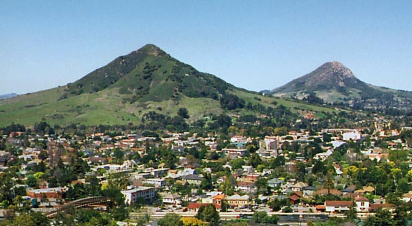
San Luis Obispo, California
High pressure is back out there, everyone. it’s dominating the majority of the country this week, and the southwest US is no exception. The hardest part of the day will be leaving San Luis Obispo (because it’s so lovely) but we will arrive with no concerns at the Crookton Road exit, east of Seligman, Arizona.
DAY TWO (Tuesday) Nothing is really going to change on Tuesday, except for our location. We will see some rising and falling terrain, but not any real weather change. Heck, we’ll even be on I-40 the whole way. We’ll make it to Tucumcari, New Mexico, before this easy day concludes.
DAY THREE (Wednesday) Our good luck continues on Wednesday, as we spend much of the day in a calm, quiet Texas. The road will be clear, but be wary of traffic in Dallas, because it will have been a while since we saw any. The jet will start forming a kink south of Texas, and that can portend bad news for the atmosphere, but it won’t yet, not on Wednesday. We stop in Canton, Texas for one last pit stop.
DAY FOUR (Thursday) The trough will indeed start stirring up some wet weather, but it won’t emerge until after we are on our way into Mississippi. The rain will be over Mexico, low pressure in west Texas, and mostly sunny skies in Hattiesburg.
This has been a busy January. Not only have we had a lot of forecasts, but they have all been during or very close to significant weather. The real test will be if we can keep it up with a forecast in California.
AT 256PM, PT, San Luis Obispo was reporting a temperature of 58 degrees with overcast skies. A weak wave was moving through the Pacific Northwest, and sweeping a mid level cold front as far south as Point Conception. There were scattered showers through out the region, though right now, the heaviest precipitation is diminishing between San Luis Obispo and Bakersfield, with another batch closer to Los Angeles. The rain is expected to linger in the area, though mostly inland from San Luis Obispo and south towards the LA Basin. The onshore flow behind the boundary will mean that San Luis Obispo will see some overcast through the day Thursday even if they don’t get much more rain. An advancing ridge should bring clearer skies to end the work week. Tomorrow – Mostly cloudy, with a few breaks late. Early sprinkles, High 64, Low 50 Friday – Sunny with a bit of morning haze, High 72, Low 45
TWC: Tomorrow – Intervals of clouds and sunshine. High 67, Low 53 Friday – Intervals of clouds and sunshine. High 72, Low 47
AW: Tomorrow – Low clouds giving way to sunshine High 70, Low 55 Friday – Partly sunny and pleasant High 74, Low 48
NWS: Tomorrow – Patchy drizzle before 10am. Mostly cloudy, then gradually becoming sunny, High 65, Low 51 Friday – Mostly sunny High 69, Low 49
WB: Tomorrow – Mostly cloudy in the morning, then sunny. Patchy drizzle in the morning, High 67, Low 53 Friday – Partly cloudy, High 71, Low 47
WN: Tomorrow – Partly cloudy with patchy drizzle, High 66, Low 51 Friday – Partly cloudy, High 69, Low 49
CLI: Tomorrow – Sunny, High 69, Low 50 Friday – Mostly cloudy, High 73, Low 48
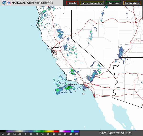
It IS raining in southern California, but things are improving quickly. Now, here is the ultra rare SOCAL RADAR!
Today we take a trip to the Southwest, where the big story the last few days have been unrelenting Santa Ana winds and massive brush fires kicking up from Sacramento to Los Angeles. Will San Luis Obispo be spared from nature’s fury as we head into the weekend?
At 950pm PDT, the temperature at San Luis Obispo, CA was 46 degrees under fair skies. High pressure continues to settle in from the Northern Rockies into the Central High Plains, keeping pretty much the entire Western US dry as a bone. Luckily, the Santa Ana’s will be weakening tomorrow after an intense event the last 3 days, which caused the Los Angeles NWS office to issue an Extreme Red Flag Warning, something that’s not in their official lexicon but they needed to convey the danger that 60-80mph winds an 1-5% humidity can cause. While a number of fires popped up, SLB avoided the worst of it, save for some air quality issues. Friday is expected to see some breezy conditions in the morning but settle down throughout the afternoon hours. After that, it looks to be a fairly pleasant weekend with generally subdued winds.
Friday: Sunny. High 81, Low 41.
Saturday: Sunny. High 79, Low 40.
TWC: Friday: Sunny. High 80, Low 43.
Saturday: Sunny. High 80, Low 41.
AW: Friday: Sunny and pleasant. High 80, Low 40.
Saturday: Sunny and pleasant. High 80, Low 38.
NWS: Friday: Sunny and breezy. High 80, Low 41.
Saturday: Sunny. High 78, Low 42.
WB: Friday: Sunny. High 79, Low 42.
Saturday: Sunny. High 80, Low 42.
WN: Friday: Sunny. High 80, Low 41.
Saturday: Sunny. High 78, Low 42.
FIO: Friday: Clear throughout the day. High 78, Low 47.
Saturday: Clear throughout the day. High 79, Low 50.
The Desert Southwest is pretty much clear as clear can be. The nearest significant cloud system is in the Northern Plains.