Much of the upper Midwest, in addition to being off to a fairly cool start to June, has also offered up respiratory distress for many of it’s residents. Canadian wild fire smoke has plagued the region, thanks to a northerly regime and some light intermittent showers bringing the smoke aloft down to the surface. The first day of June, coincidentally the second day of our forecast period in Green Bay was the first really impactful day of the smoke for many locations. It has been a bit worse further to the west from Green Bay, but the north wind and diffused sunlight ensured that temperatures didn’t spike despite the sunshine. There was a three way tie at the top of the forecast charts. The National Weather Service and WeatherNation had the same forecast, so naturally were a part of the tie, but Victoria-Weather came about it a different way and still ended up in the three way knot. Actuals: May 31st, High 73, Low 43 June 1st, High 74, Low 42
In NFL circles, Green Bay is known as the “Frozen Tundra”. Something tells me that, rolling into June, that name isn’t as apt.
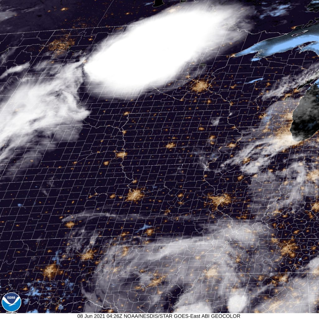
At 456PM, CT, Green Bay was in reporting rain. There were spotty showers and thunderstorms throughout the region, including a few that have been severe with large hail. A broad area of low pressure centered over Eastern Canada is trailing a few different frontal and post frontal bands. There is severe weather s a result of this system on the east coast, and the weather in Eastern Wisconsin is the most significant post frontal activity. The disorganized upper level pattern surrounding the trough is going to coalesce as a jet trough overnight into tomorrow morning. This will make the overall pattern more transient. Lingering shower activity will wrap up this evening, and tomorrow will be dry as a weak ridge enters the picture. The next feature will be more appropriately centered for this time of year, and will emerge from the Canadian Prairies. By Sunday afternoon, America’s Dairyland will be within the warm sector of this feature, with some isolated showers and storms popping up late in the day over central Wisconsin, but the Lake cooled air should keep them away from Green Bay. Tomorrow – Partly cloudy, High 71, Low 46 Sunday – Mostly sunny, warmer with isolated clouds late, High 76, Low 43
TWC: Tomorrow -Sunny skies. High 73, Low 47 Sunday – Sunny. High 77, Low 44
AW: Tomorrow – Partly sunny and nice; wildfire smoke will cause the sky to be hazy High 73, Low 47 Sunday – Hazy sunshine and warm; smoke from Canadian wildfires will obscure the sky High 79, Low 44
NWS: Tomorrow – Areas of smoke after 4pm. Sunny, High 69, Low 45 Sunday – Sunny, High 75, Low 43
WB: Tomorrow – Sunny. Areas of smoke in the afternoon High 70, Low 48 Sunday – Sunny. High 74, Low 46
WN: Tomorrow – Mostly sunny, High 69, Low 45 Sunday – Sunny, High 75, Low 43
CLI: Tomorrow – Sunny, High 77, Low 47 Sunday – Sunny, High 79. Low 42
For more on that smoke, take a look at the WBAY weather forecast. For more on the storms this afternoon, check out the radar loop below. For more on the forecast from Clime tomorrow, I can’t help you.
Green Bay is known as the frozen tundra to NFL fans the world over, but this was not the case in June 2021. Temperatures hovered near 90 on Tuesday and Wednesday, as storms avoided the area. Fortunately for homes without air conditioners, the temperatures cooled off a bit more than had been in the forecast, which hopefully meant a decent nights sleep for residents worrying about Aaron Rodgers’ future with the Packers. Weatherbug was able to parlay the cooler temperatures into a forecast victory. Actuals: Tuesday, High 91, Low 69 Wednesday – High 89, Low 69
As summer has arrived, a lot of people have started thinking about going to the lake and dipping their toes in refreshing waters, though for some reason, I’m not sure Green Bay has often stood out as a desired vacation destination, at least not when it isn’t football season.
At 1053PM, CT, Green Bay was reporting a temperature of 76 with clear skies. That temperature, warm for the middle of the night, was augmented by a dew point of 70. A clammy fog will likely roll into the near shore areas in the morning, and air conditioners will be stressed over night. Low pressure in the northern Rockies was helping draw more warm humid air north, while a surface trough in the Dakotas was feeding off of the potential energy and triggering thunderstorms across the northern Plains. Though they look impressive, they won’t reach eastern Wisconsin, withering as they get away from actual forcing. There is a weak trough northeast of the Ozarks, and surface low pressure over the Rockies, the Great Lakes are predominantly under a broad, nearly continent wide ridge. Still, given the soupy conditions across Wisconsin, an area thunderstorm will be possible for the next couple of days, particularly in the afternoon. Tomorrow – Hot and humid, with isolated evening storms, High 90, Low 70 Wednesday, more of the same, including storms, High 87, Low 68
TWC: Tomorrow – Intervals of clouds and sunshine. A stray shower or thunderstorm is possible.High 89, Low 69 Wednesday – Sunshine along with some cloudy intervals. High 84, Low 63
AW: Tomorrow – Periods of sun with a thunderstorm in a couple of spots; very warm High 92, Low 74 Wednesday – Very warm with intervals of clouds and sun High 87, Low 67
NWS: Tomorrow – A slight chance of showers between 9am and 1pm, then a slight chance of showers and thunderstorms after 1pm. Patchy fog before 9am. Otherwise, partly sunny, High 88, Low 70 Wednesday – Mostly sunny, High 85, Low 67
WB: Tomorrow – Humid, Partly sunny. A slight chance of showers in the morning then a slight chance of showers and thunderstorms in the afternoon, High 91, Low 74 Wednesday – Mostly sunny, High 89, Low 70
WN: Tomorrow – Partly cloudy with isolated storms, High 88, Low 72 Wednesday – Mostly sunny, High 85, Low 67
FIO: Tomorrow – Humid and partly cloudy throughout the day. High 88. Low 70 Wednesday – Partly cloudy throughout the day. High 84, Low 63
Really hit or miss with those thunderstorm chances. The activity east of Fargo sure isn’t missing tonight.
The Upper Midwest has had a consistent, cyclical pattern of late, generally transpiring over the course of a week or so. Warm over the weekend and through the early part of the week, then the threat of a little bit of precipitation, very cold by Thursday and warming up again for the weekend. It’s happening this week, and it happened last week in Green Bay. Forecasters generally saw that pattern and latched on to it in their forecast. The issue came down to temperature, as forecasters were a couple degrees too warm for where this cycle ended up falling in line. There was a three way tie atop the standings in the end, with the Weather Service, Weather Nation and Forecast.io splitting the winning share. Actuals: Thursday – High 15, Low -7 Friday – High 31, Low 3
The drive from eastern Wisconsin to central South Carolina, if taken today, would be slowed mightily by rain gripping a wide swath of the eastern United States. We will start this two day trek tomorrow, though, so nothing to fear! The drive will cover 1,013 miles, which we will in turn cover at a pace of 65.3mph. The second day will be a little bit shorter, by a half hour or so, and our target distance on Tuesday will be 523 miles. all very manageable, yes?
DAY ONE (Tuesday)
Green Bay, Wisconsin (By Chris Rand)
Low pressure moving through the eastern portion of the country is gradually unraveling today, and will continue to tomorrow. That means that precipitation which was translating quickly earlier in the week is slowing way down. None of it is reaching into Wisconsin, so the drive south towards the Illinois line should be drama free, but when we hit the Windy City, there is a pretty good chance it will be snowing. The snow will continue in this inverted trough south through Indiana, with a gradual change to rain south of Indianapolis. Precipitation won’t be heavy, but it won’t need to be to slow travel down. We’ll reach the eastern suburbs of Louisville, particularly the town of Middletown, by the end of the day.
DAY TWO (Wednesday) The back end of that system will swing to the south overnight. The dry slot will disappear from west of the Appalachians, and the light snow will return to our route, and last through our drive in Kentucky. We will turn south at Lexington and there might be a window of dry air by the time we reach Knoxville, which should last us through the rain shadow afforded by the Smokey Mountains from Asheville to Spartanburg, but the cold front associated with this low will start to redevelop on Wednesday afternoon. More rain will move into Columbia from the south, and will be there to greet us upon our arrival.
When you think of beachfront communities, I’m not sure Green Bay and Lake Michigan often come to mind. Northeast of Green Bay is Door County, though, which is an idyllic vacation spot. In the summer, though, probably not right now.
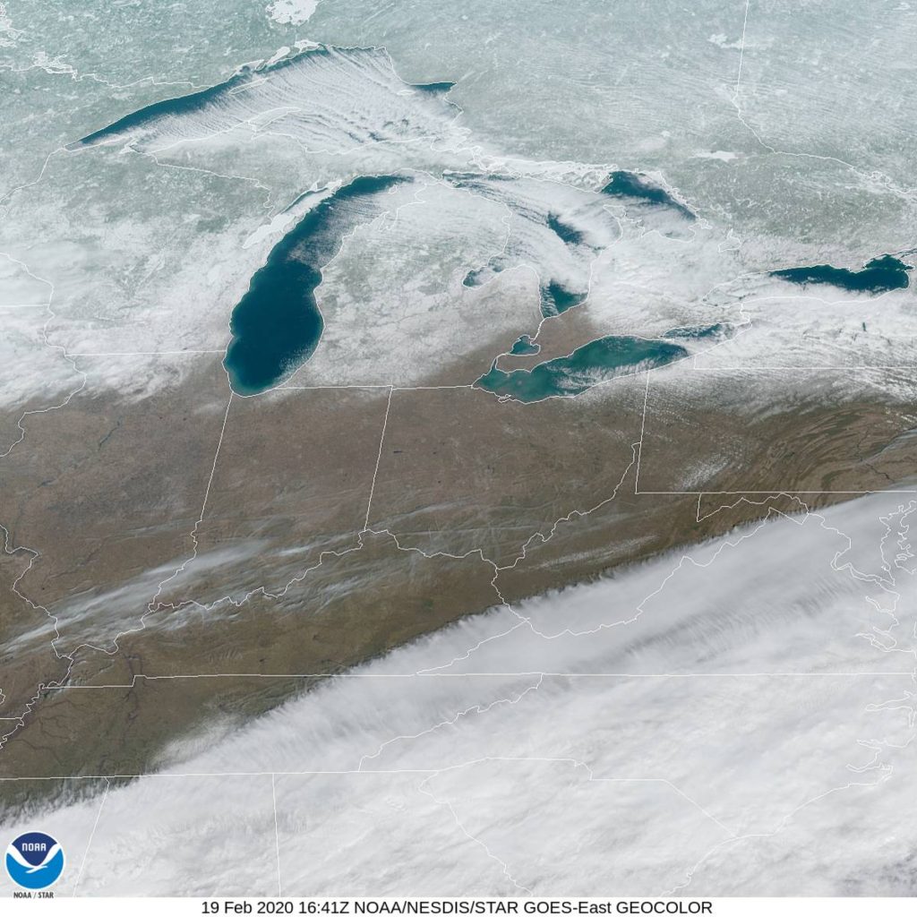
At 953AM, CT, Green Bay was reporting clear skies and a temperature of only 7 degrees. Clear dry air prevailed in the Dairy State thanks to the west winds, though some clouds were seen in the Upper Peninsula of Michigan thanks to flow coming off of Lake Superior, which has remained open this winter. Surface high pressure is in control thanks to a broad trough lying along the southern third of the country. Unfortunately, with the jet as far south as it is, warm air is pinned in the Gulf, and the ridge is particularly chilly. A shortwave upper level trough is translating through the Great Lakes as well, functioning similarly to a thermal trough, though mostly because it is left without a source of moisture. Still, as it pivots away from the area, a warm up can be anticipated simply due to the increased sun angle as we approach spring. Tomorrow – Mostly sunny, High 16, Low -4 Friday – Sunny and warmer, High 34, low 6
TWC: Tomorrow – Mainly sunny. High 15, Low -3 Friday – A mainly sunny sky high 33, Low 5
AW: Tomorrow – Very cold with plenty of sunshine High 16, Low -3 Friday – Not as cold with plenty of sun High 33, low 6
NWS: Tomorrow – Sunny, High 16, Low -4 Friday – Sunny, High 32, low 5
WB: Tomorrow – Sunny, High 13, Low -3 Friday – Sunny, High 31, Low 6
WN: Tomorrow – Sunny, High 16, Low -4 Friday – Sunny, High 32, low 5
FIO: Tomorrow – Clear throughout the day. High 16, low -4 Friday – Windy in the afternoon and evening. High 33, Low 4
Brr! Ok, this is probably another reason most people don’t think of Green Bay and beaches. here is the satellite imagery. A lot of the white is actually snow on the ground, rather than clouds.