It was forecast to be quite warm last week in Fayetteville. Make no mistake, it was quite warm, but there were several degrees between what occurred and what still stands as records for the 14th and 15th of April. Accuweather in particular was feeling strongly that there was a chance for record temperatures, but the numbers skewed towards the lower forecast values. The top forecast belonged right here, at Victoria-Weather. Actuals: Tuesday – High 86, Low 59 Wednesday – High 90, Low 61
We are headed down to the Carolinas today. As things get warmer, weather is starting to get more convective. Will that be the case in North Carolina?
At 1010AM, ET, Fayetteville was reporting scattered clouds and a westerly breeze gusting to about 20mph. Elsewhere in the area, dew points of over 60 were leading to some haze, which the wind was doing a good job of scouring. There is a boundary to the west of the Appalachians that is in the process of fading, but has done an effective job of drawing warm moist air into the Carolina coastal plains. That boundary is fading as low pressure deepens in the northern Plains. This will reinforce both the jet ridge over the east coast, and the warm, oceanic air in Fayetteville. Clouds will increase with the temperature, but a dry couple of days are anticipated. Tomorrow – Mostly sunny, High 88, Low 59 Wednesday – Partly cloudy, High 91, Low 61
TWC: Tomorrow – Mostly sunny skies. high 89, Low 60 Wednesday – Generally sunny. Near record high temperature High 92, Low 62
AW: Tomorrow – Partly sunny and very warm with the temperature tying the record high from 1922 High 92, Low 59 Wednesday – Partly sunny and hot with the temperature approaching the record high of 95 set in 2006; caution advised if doing strenuous activities outside High 94, Low 61
NWS: Tomorrow – Sunny, High 89, Low 61 Wednesday – Sunny, High 92, Low 64
WB: Tomorrow – Mostly sunny. High 86, Low 65 Wednesday – Sunny hot High 89, Low 67
WN: Tomorrow – Mostly Sunny, High 89, Low 61 Wednesday – Mostly sunny, High 92, Low 64
CLI: Tomorrow – Sunny, High 88, Low 58 Wednesday – Partly cloudy, High 91, Low 61
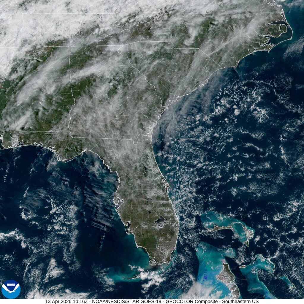
Easy peasy. Satellite shows some scattered clouds across the southeast.
It’s going to be a one day cross section of middle America. From northern Indiana to northwest Arkansas, we will take a long, 11+ hour day, covering 742 miles, for a pace of nearly 66mph. Indiana and Arkansas are closer than you think!
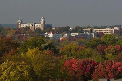
Elkhart, Indiana
A weakening system over the Great Lakes is getting drawn into the sphere of influence administered by a larger system trekking through the Gulf Stream. The weaker trailer is bringing some light rain to Elkhart tonight, but will be out of the picture by tomorrow morning. The feature is dangling a trough southward before it curls to the west, where it will lie stationary tomorrow. High pressure is building in over the north central US, but it won’t overpower the boundary and send it further south. Instead, the tail of the front will pass through the Ozarks, and while we will probably use our northern route to avoid any visibility issues, we will still enjoy them in their misty glory upon our arrival in Fayetteville.
The middle of October was a fairly quiet time for those interested in all things weather, so a little bit of a disturbance rippling from the southern Plains to the mid-Mississippi Valley qualified as interesting. It certainly added intrigue to our forecast for Fayetteville, as it resulted in a smattering of rain on both days of the forecast period, and even more surprisingly, led to fairly warm overnight lows from the 10th to the 11th. The Weather Channel won because they had warmer lows on the 11th, but also were one of the only two outlets with rain in the forecast on both days of the period. Actuals: October 10th, .01 inches of rain, High 76, Low 50 October 11th, .02 inches of rain, High 81, Low 68
There are two options for Fayettevilles in the United States. I’ve only been to the one in Arkansas, and it is definitely not what you expect in “Arkansas” given the haven of Fortune 500 companies, University and tourism. What kind of weather is coming their way?
At 853PM, CT, Fayetteville was reporting a temperature of 59 degrees with clear skies. It was a continuation of dry weather, and there were burn bans across most of the region. The Ozarks were seeing cooler temperatures than surrounding regions, owing to the terrain of northwest Arkansas. Surface high pressure is dropping southward within a complicated jet trough. The nature of the troughing pattern is such that precipitation is being inhibited and moisture is being staunched at the Gulf. This will lead to more quiet weather tomorrow, however as the surface ridge sinks south, baroclinicity will arrive across the region, importing some moisture from the monsoon. This isn’t going to lead to a lot of wet weather, but some rain and clouds are possible overnight Monday into Tuesday. Expect a breezier day on Tuesday. Tomorrow – Increasing clouds with some late rain, High 79, Low 52 Tuesday – Mostly cloudy, with some early showers, High 79, Low 58
TWC: Tomorrow – Some sun in the morning with increasing clouds during the afternoon. (PM storms), High 78, Low 53 Tuesday – Cloudy. Slight chance of a rain shower. High 81, Low 61
AW: Tomorrow – Some sun, then turning cloudy High 77, Low 54 Tuesday – Beautiful with periods of clouds and sun High 79, Low 61
NWS: Tomorrow – Partly sunny, High 80, Low 54 Tuesday – A 20 percent chance of showers and thunderstorms before 1pm. Mostly cloudy High 80, Low 60
WB: Tomorrow – Partly sunny, High 77, Low 56 Tuesday – Mostly cloudy. A slight chance of showers and thunderstorms in the morning. High 80, Low 63
WN: Tomorrow – Partly cloudy, High 80, Low 53 Tuesday – Mostly cloudy with isolated storms, High 80, Low 60
FIO: Tomorrow – Partly cloudy throughout the day. High 78, Low 56 Tuesday – Possible light rain in the morning. High 79, Low 60
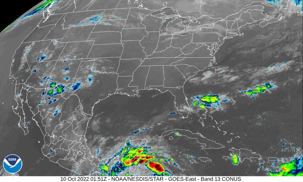
It’s fun when there is a variety to the precipitation forecasts. We’ll see how it plays out! Not much on satellite right now, but it will likely change in the next 48 hours.
I wrote the forecast for Fayetteville before I wrote the post about cold fronts failing to take hold in the center of the country. That should tell you something about how this forecast went. Sure, there was a weak boundary sinking through the area earlier this week, but I thought it would bring a bit of northerly flow and some more comfortable air to northwest Arkansas. Instead, temperatures went up by a couple of degrees as the temperatures simply reflected the amount of rain that was seen in the day. A heavy AM thunderstorm on Sunday helped temperatures stay below 90, while they climbed over that mark on Monday, a drier day. The top forecast was split between Accuweather and the Weather Service. Actuals: Sunday – .28″ of rain in thunderstorms, High 89, Low 73 Monday – .03″ of rain, High 92, Low 72
It’s time for another road trip. This route takes us from one state to another that borders another, but we are going to cut through a third to get there. The drive covers about a day and a half, and is 762 miles long. There will be an ample amount of time spent on I-35, which will allow for a pace of 62.9mph. Not as fast as you expected? Well, that’s because of some off – interstate driving through Oklahoma. We’ll work out about 503 miles of driving on Tuesday, with the remainder on Wednesday.
DAY ONE (Wednesday)
Laredo, Texas (via Britannica.comdn
Our day will start from the Mexican border, and take us north through Texas on 35. We will abandon 35 as we head through the Dallas Metroplex and head for the Red River. There is a tail of a weak boundary sagging south through Texas that will trigger an isolated shower or thunderstorm generally north of the Austin area. Nothing severe or long lasting, but just enough to dampen the pavement from time to time. Just before we arrive at the Red River crossing, we will stop for the night in Denison.
DAY TWO (Thursday) As the tail of that boundary drifts further south, it will clear the air in Oklahoma and western Arkansas. Well, not clear it, so much as bottle up the shower and thunderstorm threat to the south of our route. Be prepared, it’s going to be hot and miserable in Fayetteville when we arrive. Find air conditioning.
Arkansas has a surprising number of cities that we can drop forecasts for. The Northwestern Arkansas corridor is definitely more lively than one would normally be lead to believe.
At 953PM, CT, Fayetteville was reporting a temperature of 79 degrees with clear skies and dew points also parked in the upper 70s. It is a surely uncomfortable night which will see some haze across the region by morning. There are heat advisories out across the region, except in the Fayetteville area, where terrain and foliage will help blunt the high temperatures. Low pressure in the Hudson Bay area is the only particularly well organized system in North America, and it is dangling a generally ineffectual boundary through the heart of the country. It is peeling back dew points a bit, and promoting a moist flow through the Lower Mississippi Valley northward, and will continue to do that through the day Sunday. The weak boundary will arrive in town by evening, and may lead to a more comfortable Monday, with isolated thunderstorms a distinct possibility throughout the day on Monday, but also in the evening on Sunday. Tomorrow – Partly cloudy, afternoon thunderstorms. Humid. High 92, Low 73 Monday – Mostly cloudy, scattered showers and storms, High 89, Low 70
TWC: Tomorrow – Scattered thunderstorms in the morning, then partly cloudy late High 92, Low 72 Monday – Partly to mostly cloudy. A stray shower or thunderstorm is possible. High 91, Low 71
AW: Tomorrow – Sun and some clouds with a thunderstorm in spots in the afternoon High 92, Low 73 Monday – Humid with more clouds than sun; an afternoon thunderstorm High 91, Low 72
NWS: Tomorrow – A 30 percent chance of showers and thunderstorms, mainly before 1pm. Partly sunny, High 93, Low 73 Monday – A 40 percent chance of showers and thunderstorms. Partly sunny, High 92, Low 72
WB: Tomorrow – Mostly cloudy with chance of showers and thunderstorms in the morning then partly cloudy with slight chance of showers and thunderstorms in the evening. High 90, Low 75 Monday – Partly cloudy with a 50% chance of showers and thunderstorms, High 89, Low 74
WN: Tomorrow – Partly cloudy with a chance of storms, High 93, Low 72 Monday – Partly cloudy with a chance of storms, High 92, Low 71
FIO: Tomorrow – Humid and partly cloudy throughout the day. High 92, Low 73 Monday – Humid and partly cloudy throughout the day. High 89, Low 72
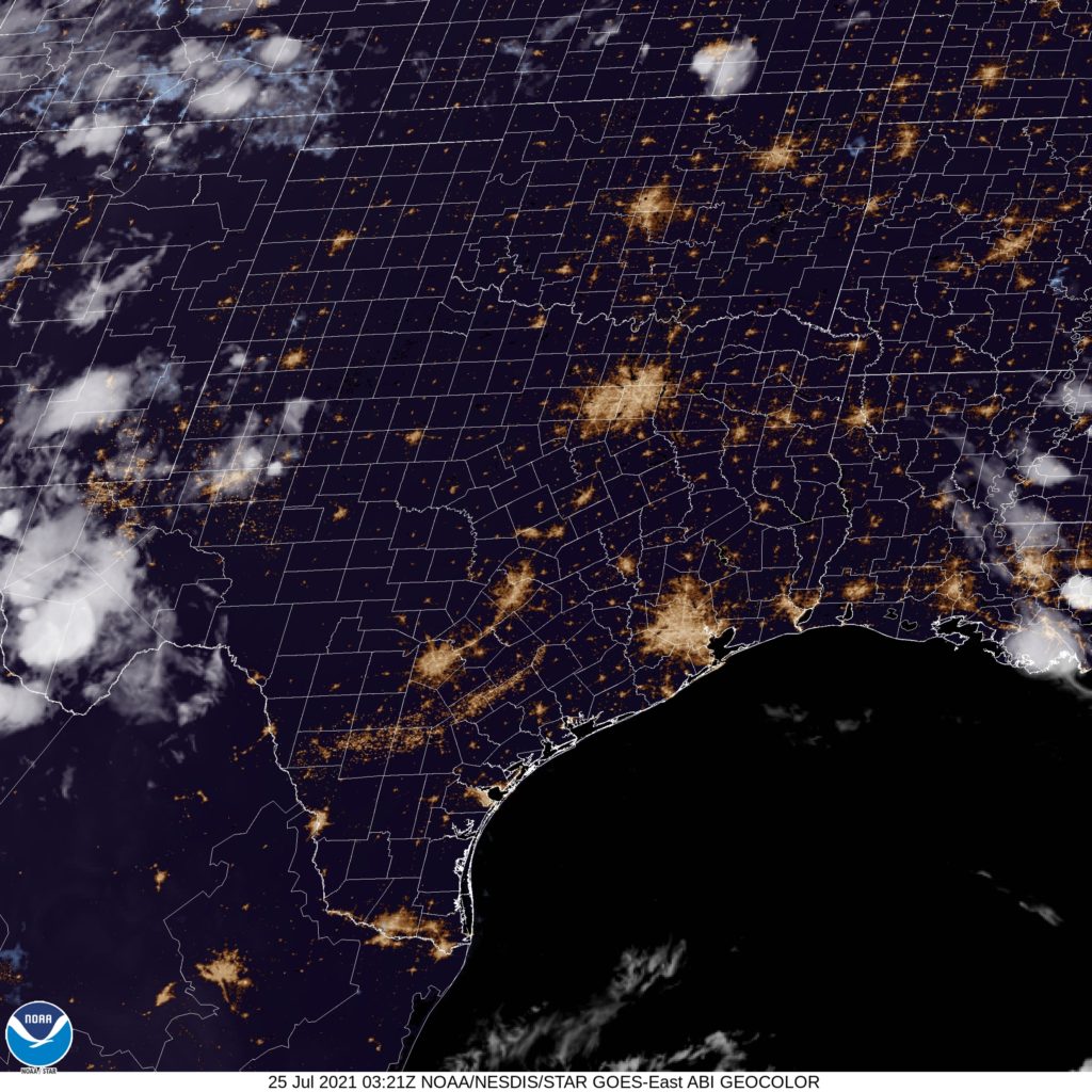
Here is the satellite for the evening, which just shows how clear the skies are to night in the south central US.
Something as a swan song to the persistent trough that had been bringing showers and thunderstorms to the middle of the country, Fayetteville reported showers and thunderstorms on both Sunday and Monday. The wet weather was not nearly as significant as it had been, and it didn’t even show up on Tuesday. The benefit was that temperatures were comfortable in the 80s, and that the forecast was skillful. The Weather Channel, Weather Service and Weathernation all tied at the top spot. Actuals: Sunday – .15 inches of rain, High 84, Low 70 Monday – .01 inches of rain, High 85, Low 69
There are certainly a few different Columbia to Fayetteville options out there, and this was the longest trip possible of any of those combinations. This particular iteration will result in a day and a half drive, covering 921 miles. The pace between these SEC college campuses will be a somewhat tame 61.9mph covering 495 mile on our first day of travel. Let’s just get going, then.
DAY ONE (Sunday)
Columbia, South Carolina
It’s certainly a nuisance for residence from the central Plains to the Great Lakes to have to endure several days of rain and thunderstorms, but as we drive from Columbia through northern Georgia, we will reap the benefits. The moisture being directed further to the north and west will allow the southeast to dry out a bit. A stream of moisture keeps showing up on the various model runs in the late evening over eastern Alabama, so don’t be surprised to see a little rain from the Georgia line to Birmingham. Mostly cloudy, warm and muggy conditions will continue west to Tupelo, Mississippi where we will round out the day.
DAY TWO (Monday) The five plus hours through northern Mississippi, and across the state of Arkansas will be increasingly cloudy, and the higher terrain in northern Arkansas is likely to see spots of misty fog. Rain should stay clear of our route, but for the very end, when an isolated thunderstorm will certainly be possible along the hilly I-49 stretch, reaching into Fayetteville.