East Coast getting pounded

As a lot of people south and west of a line from Virginia Beach to Toledo can tell you, it’s raining in buckets out there. At least it is happening at the end of the long Holiday weekend, and surely sets the mood for a lot of us as we log back into work on Monday.

The satellite imagery belies the prolific nature of the rain. There isn’t much apparent rotation, no puffs of cumulonimbus across most of the band of clouds, with only a few apparent thunderstorms in the Florida Panhandle.

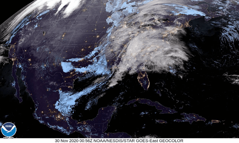
Now that I’ve warned you, perhaps you looked a little more closely, and found the circulation futher to the west of the erupting thunderstorms and swath of white clouds running from the Mid-Atlantic to north Florida.

Indeed, the bulk of the rain so far is the result of warm frontal passage over the undulating Appalachian terrain. That boundary currently runs from eastern Kentucky through eastern North Carolina, has proven to be quite rainy. The warm sector south of the boundary and ahead of the cold front, which is setting off thunderstorms through the Panhandle, is also rife with showers and a few rumbles of thunder.

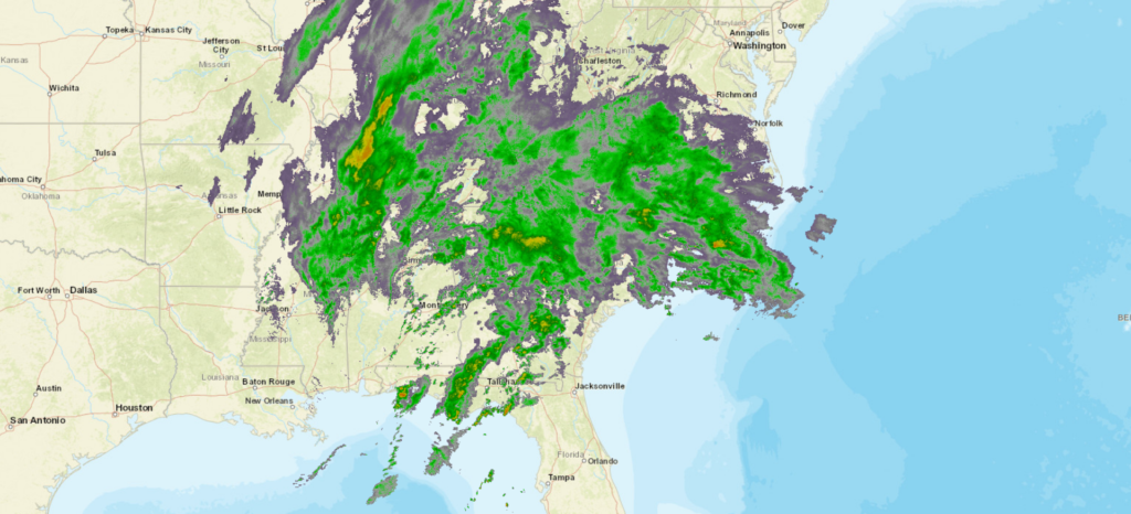
Perhaps the most winter like element to this storm imagery is the glut of water on the back side of the center of circulation, which is around Florence, Alabama. Usually, temperatures don’t allow for much condensation on the inverted trough during the summer, let alone torrential rain. Temperatures are chilly aloft, and this feature is pulling in more cold air into it. Not enough for snow in southern Indiana, but getting colder.

This feature has a great deal of support at the upper levels, an will continue to wind up. Away from the moisture rich southeast, and interference of the Appalachians, the cold front will become more evident, but by that time, the warm sector will be off shore. The low itself will barrel north, just like a winter nor’easter. It will have the wind of a nor’easter, and by the time the storm has shifted out of the Mid-Atlantic by Tuesday morning, Lake effect snow is anticipated for the eastern Great Lakes.

The heavy rain, along with some gusty wind and a rogue rumble of thunder will continue in coastal New England on Tuesday, but should shift off shore before Wednesday rolls around. This feature looks like a winter storm in the models, and a little bit on satellite and radar. It will almost feel like it, too.

Thanksgiving week has a few different plans

This weekend has been pretty nice across the country, with little in the way of watches or warnings or intrusions of cold air or wet weather. Unfortunately, it is only late November, and winter is not yet cancelled.

In fact, there maybe a couple of features that bring wet weather and less pleasant conditions to the country this week. First, early this week a feature will come out of the Rockies and move into the Plains, bringing rain, snow and cooler air to the middle of the country.

The feature will shift towards the Great Lakes, with showers and thunderstorms south from the Ohio River, and a real possibility of lake enhanced snow mid week before shifting out through New England late in the week.

A couple of other surges of wet weather will be possible with a feature arriving in the Pacific Northwest on Tuesday, which might lead to some significant problems in the mountains for casual travelers, but probably not those that are used to it.

Late in the week, a system will develop in the Lower Mississippi Valley with cold air driving in from the northwest. It will predominantly be a rain maker, initially in Mississippi and Louisiana, but shifting northeast before clobbering the Ohio Valley again, and eventually the entirety of the Eastern Seaboard. Again, it should all be rain at least through next Sunday, with some thunder further south.

Now, as for the beginning of December. A developing area of low pressure in the mid-Atlantic might make things a bit more wintry. But we’ll talk about that again at a different time.

Yuba City, California to Abilene, Texas

Hi! Happy Saturday! We are heading into what is usually one of the busiest travel times of the year. This year will obviously be a little bit different, but the weather will still carry on, so let’s drop this three day forecast for the southwestern part of the country. Our drive will cover 1,606 mile at a pace of 67.6mph, which will indicate a pace of 541 miles on those first two days, and a shorter day on Tuesday. Let’s hit the old dusty trail.

DAY ONE (Sunday)

Yuba City, California

There is a bit of a system moving into the west coast this weekend, but in the part of the coast that you would expect it, not the Mojave desert or San Joaquin Valley. In fact, a thermal ridge suggesting pretty warm temperatures will be in place as we drive through the Golden State. We won’t make it out, stopping at the dusty oasis of Ludlow.

DAY TWO (Monday)
Low pressure dives in from the Pacific Northwest to the central Rockies on Monday, and by the end of the day, may start causing some issues in the higher terrain. We will drive from Ludlow through Arizona without any concerns, buy in the last couple of moments, some rain and elevation snow may be possible in New Mexico. We will still remain mostly dry, stopping for the night in Mesita, west of Albuquerque.

DAY THREE (Tuesday)
The low in the center of the country will deepen fairly quickly as it descends into the Plains. Not a lot of wet weather will move into eastern New Mexico and west Texas, but a healthy rush of cold air will run into the region. There will be a few storms ahead of us, but they will be out of Abilene before we get there. Bundle up, furnaces aren’t as efficient in this part of the world.

Abilene, Texas By Atownbman – Own work, CC BY-SA 4.0, https://commons.wikimedia.org/w/index.php?curid=74638447

Watch out for a strong polar vortex (That’s a good thing)

One aspect of emerging media and is the rapid dispersal of terms that come up in the news. Some things have always been there, and just get out of hand when they enter the news cycle. Things like “bomb cyclone” seem absurd to the point of frivolity if you don’t know the definition. I’ve gotten into debates on Twitter about Particularly Dangerous Situations being assigned to some weather watches, because the other Twitter user thought meteorologists were being overdramatic in their terminology. It’s a lesson in never using Social Media.

One term that really exploded in the last half decade was “Polar Vortex” which emerged in the midst of a persistent cold snap that was particularly cruel to the Eastern Seaboard. Since the East Coast is where most media, and really most of the people in the country reside, the term was foisted upon the country. There were some amusing consequences.

But mostly, it just annoyed meteorologists, because the colloquial definition of the polar vortex is not correct. As the media may have led some to believe, the polar vortex is not just a surge of cold air that dive bombs the mid latitudes out of the Arctic.

A vortex is something that rotates, The Polar Vortex, then, is the Arctic jet that spins around the North Pole. Ergo when it is strong, as is the case with all jet streams and streaks, it represents a sharp temperature contrast on other side of the streak. While it will certainly be cold north of, or within the vortex, it’s strength suggests that it will actually be fairly warm south of it.

Weaker flow can lead to some ripples in the jet, which can mean lobes of cold air pressing further south, particularly later in the year when high latitudes start to get colder on their own. Right now, though, it looks like we have a stout Polar Vortex to guide us into winter, and that is a good thing.

Buffalo, New York to Florence, South Carolina

Sometimes, but not very often, a road trip comes along, and the route that Google comes up with a route that I was not expecting. This is one of those times! Instead of a route down the coast, we’re going to be headed through the mountains of Appalachia for a day and a half. The drive will cover 767 miles at a pace of a mere 61.5mph. Thanks, mountains! We’ll leave ourselves with a half day after driving 492 miles on the first day.

DAY ONE (Thursday)

Buffalo, New York

High pressure will be the name of the game on Thursday, keeping any inclement weather at bay. The drive is one in which we will appreciate the dry weather, as moving through the mountains is difficult enough as it is. There isn’t a single straight road in central Pennsylvania or the entire state of West Virginia, which is fun because of the scenery, but less enjoyable when the weather gets a little sideways. It might start to get a bit breezy by the end of the day, and we’ll pull off for the night in Bluefield, West Virginia, which is on the border with Virginia, right before a long tunnel that goes under the state line.

DAY TWO (Friday)
The big difference between Thursday and Friday for our little drive will be the terrain. Friday will be a much flatter day. Weatherwise, the big change will be a reduction in the wind. It will be still and pleasant for the duration of our drive, should you be so inclined to pull off at a random road side Waffle House. Or just wait, and get lunch in Florence, it’s only a 4 1/2 hour drive on Friday.

Florence, South Carolina

The Tropical Season just won’t quit

2020 has now surpassed 2005 as the most active tropical season in the North Atlantic in recorded history. We’ve exceeded the total of named storms by two, dipping further into the Greek alphabet than ever before. The long lived Eta has made the most of it’s first appearance in our meteorological lexicon, while Theta is spiraling out by the Azores, and Iota is preparing to landfall in Central America, near where Eta initially exploded on the scene. Similarly, Iota is expected to become a hurricane, with the present forecast asserting that Iota will be a major hurricane upon besetting the Nicaragua/Honduras border with more destruction.

Fortunately, despite all the action this year, we haven’t matched the pace of hurricanes or major hurricanes of 2005, which still holds the record in both categories. A bit of good news is that, at least for the next couple of weeks, it doesn’t look like Iota has a follow up on the immediate horizon, which will make it difficult to reach the hurricane or major hurricane numbers of 15 years ago.

Of course, I say that now, but it should be noted that the Tropical Storm Zeta of 2005, the last storm of that busy year was also the first storm of 2006. In a year like this, there is plenty of time for more new ground to be covered.

What is a snow squall?

Today, a narrow band of snow swept through the Twin Cities. At one point, the wind and heavy downburst of snow brought I-94 northwest of Minneapolis to a close thanks to a multi-vehicle accident. The Weather Service then issued a snow squall warning, but what is a snow squall, exactly?

In laymen’s terms, I would describe it as something similar to a severe thunderstorm, where the precipitation isn’t necessarily the most noticeable feature to the storm. In the northwest Twin Cities metro, for example, there were 40-50mph winds associated with the quick burst of snow. Buffalo, Minnesota reported 2.5 inches of snow in 90 minutes.

That’s another thing about a snow squall. The “squall” is important, because it is akin to a squall line, as with thunderstorms. There is a leading edge, and a well defined end, particularly as the storm is at it’s strongest. Instead of a bloated mass of snow showers you get with a typical winter storm, it’s a quick, intense line.

The primary impetus for the National Weather Service issuing a snow squall warning is the reduction in visibility, such as was the case in the accident seen above. The strong winds and heavy snow lead to white out conditions, in which visibility is at or near zero. They are targeted like a thunderstorm or tornado warning, to a very specific part of the storm, even if the entire line stretches for a longer distance.

This was Minnesota’s first ever issuance of a snow squall warning. They more frequently appear east of the Great Lakes, and are quite the curiousity in Minnesota.

Cold front in the Midwest is the harbinger of winter

Today was a particularly active weather day, with low pressure in the Upper Midwest extending a cold front through the Great Lakes and on towards the Mississippi. The front itself has been the origin of severe weather from the Quad Cities south through Missouri and eventually across Big Muddy and through Illinois.

More indicative of what’s coming is the snow that fell in the Upper Midwest. 2-5″ fell in Minnesota as precipitation wrapped into the cold air diving into the country behind this system, merely a couple of hundred miles away from tornado warnings in northern Illinois.

More tangibly, I think these two images spell out the change coming for the end of the week. First, the radar imagery.

And now, take a look at tonight’s lows. There should be some significantly colder air northwest of those bands of thunderstorms.

And there is that sharp drop I promised. High pressure will move in at the surface over the Plains, and prevent much of a warm up for a couple of days. Eta will slow the cold front so all those places that will get copious rain from the tropics will remain warm few days longer.

If you didn’t believe it yet, winter looks like it is here, and will hang on.

Hazy days in Hanford

Acting as a pretty on the nose metaphor around election day, Hanford was hazy, and didn’t act as expected. An impactful haze settled into Hanford on Monday, keeping temperatures significantly cooler than expected ahead of election day. By the end of the forecast period, though, things fell into place. Weathernation had the top forecast, and it was on the strength of a nearly perfect Election Day forecast. No word on if they have been contacted by any pollsters for 2024.
Actuals: Monday, High 71, Low 47
Tuesday – High 80, Low 48

Grade: C-D