It is not a long drive that we intend to take tomorrow through Lower Michigan. It’s less than an hour and 53 miles from Battle Creek to Jackson. The Google Maps pace is 60mph, but I’ve driven I-94 in Michigan. We’ll be going faster than 60mph.
Battle Creek, Michigan
There really isn’t a lot to say here, honestly. Michigan is a nice enough state, and there are a surprising number of wineries. Not a lot of weather coming through, though. There is high pressure over the Great Lakes, with some mid layered overcast in the northern part of the lakes, but we are on the south side of Michigan, so just enjoy Jackson, I guess!
To conclude a long look at the drenching conditions brought about by Tropical Storm Nicholas, we took up a forecast for Jackson, Mississippi. The rain was slow in coming, but frankly, it has been even slower in leaving. Tere was a trace of rain last Monday, and a quarter inch on Tuesday, but then there has been rain in the area every day since. Nicholas has definitely been a bad house guest. The top forecast went to The National Weather Service and WeatherNation, as a tag team effort. Actuals: Monday – Trace of rain, High 85, Low 74 Tuesday – .25 inches of rain, High 80, Low 72
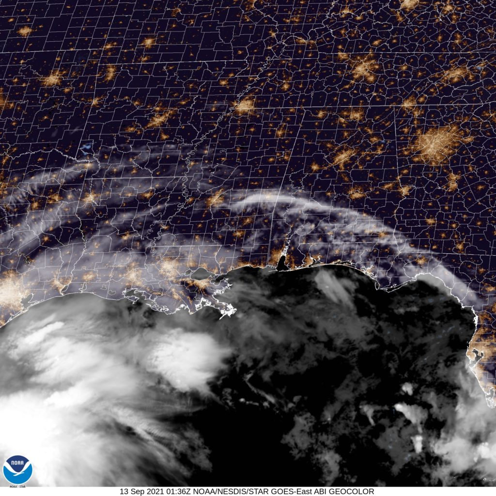
The weekend is almost through, and of course, there is more action in the Gulf of Mexico. Will it find it’s way towards Mississippi to begin this work week?
At 754PM, CT, Jackson was reporting a temperature of 76 degrees with fair skies. Dew points were high across the region, but wind should be strong enough that fog doesn’t settle in across the region overnight. The northern edge of the sphere of Nicholas’s influence is visibly over southern Mississippi, and the threat of showers and storms will return early tomorrow, when daily insolation gets started. Model guidance is, at this moment, dangerously disparate. Some guidance drives the storm into southern Texas, and leaves Jackson unbothered. The preponderance of information out there has the storm bounce a bit to the east and hold together until landfall further north, near Houston. In this eventuality, heavy rain will arrive late on Tuesday. This seems like the most likely outcome, unfortunately, and rain, often heavy, will be kept in the forecast. Tomorrow – Isolated showers and thunderstorms, High 84, Low 70 Tuesday – Increasing rain, heavy late, high 82, Low 68
TWC: Tomorrow – Cloudy. High 84, Low 71 Tuesday – Considerable cloudiness with occasional rain showers. High 82, Low 72
AW: Tomorrow – Humid with intervals of clouds and sun; a thunderstorm in spots in the afternoon High 84, Low 71 Tuesday – Cloudy and humid; a thunderstorm in spots in the afternoon High 84, Low 71
NWS: Tomorrow – A 50 percent chance of showers, mainly after 9am. Mostly cloudy, High 83, Low 71 Tuesday – A slight chance of showers, then a chance of showers and thunderstorms after 1pm. Mostly cloudy, High 82, Low 72
WB: Tomorrow – 40% chance of rain showers, High 82, Low 72 Tuesday – Slight chance of showers in the morning, then a chance of showers and a slight chance of thunderstorms in the afternoon, High 84, Low 72
WN: Tomorrow – Mostly cloudy with scattered showers, High 83, Low 71 Tuesday – Mostly cloudy with scattered showers, High 82, Low 72
FIO: Tomorrow – Humid and overcast throughout the day. High 83, Low 70 Tuesday – Rain in the evening. High 82, Low 70
It’s going to be interesting to see exactly where Nicholas wanders off to. There is even some speculation on it’s pace. Generally, there isn’t much certainty. You can see it’s outer reaches in southern Mississippi below.
I am impressed. The forecast for Jackson was locked and loaded to be very difficult. A massive blob of uncomfortable low pressure moving through the Great Lakes was going to manipulate precipitation types and drive temperatures steadily downward… except for when there was an intrusion of warm air as the low passed by on Saturday. It was a recipe for a difficult forecast, and by jove, this forecast was knocked out of the park. Weatherbug, in fact, only had 1 degree of error in their entire forecast. the only real loser was the city of Jackson, who had to deal with the rain, thunderstorm and snow chaser. Actuals: Sunday – .64 inches of rain, High 42, Low 34 Monday – Snow reported, not measured, High 34, Low 28
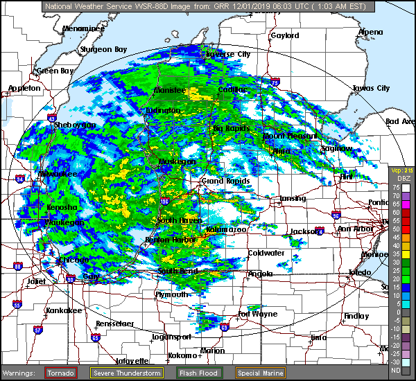
We sure are looking at an interesting forecast for the Great Lakes today. It’s a mystery even what type of precipitation will be falling in an hour.
At 1256AM, ET, Jackson was reporting a brisk 35mph easterly wind gust with overcast skies and a temperature of 37 ahead of a vast batch of heavy rain consuming most, if not all of western Michigan. A large area of occluded low pressure is centered over north central Iowa. The occluded boundary is ranging from there to Michigan. Jackson appears to northeast of the warm occlusion. Much of Michigan is in a winter weather warning or advisory, however Jackson is south of these alerts. After the rain that will come this morning, a well defined dry tongue will move into Lower Michigan through the middle of the day on Sunday. The back end of this feature is becoming significantly less organized and unable to access the same level of moisture. Still, light snow showers will persist in the Jackson region into Monday afternoon, but a cool down is not likely to follow suit after becoming cut off from the deeply occluded circulation. Tomorrow – early rain, becoming mixed and eventually predominately snow in the evening. High 37, Low 33 Monday – Light wet snow, High 33, Low 28
TWC: Tomorrow – Rain ending early. Remaining cloudy, High 43, Low 35 Monday – Overcast, early snow, HIgh 35, Low 28
AW: Tomorrow – Mostly cloudy with a couple of showers, perhaps mixed with snow late in the day High 43, Low 35 Monday – Low clouds and colder HIgh 35, Low 29
NWS: Tomorrow – Showers likely, mainly before 10am. (Late mix) HIgh 42, Low 35 Monday – Cloudy (Early mix becoming snow) HIgh 35, Low 27
WN: Tomorrow – Mostly cloudy with rain likely, High 42, Low 35 Monday – Mostly cloudy )Early mix), High 35, Low 31
FIO: Tomorrow – Rain throughout the day. High 42, Low 34 Monday – Overcast throughout the day. HIgh 35, Low 28
That was a difficult forecast. The precipitation in western Michigan has already started a transition to a mix, even as I was writing this forecast post, if that gives an idea of the uncertainty we will be dealing with.