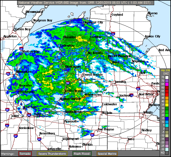
We sure are looking at an interesting forecast for the Great Lakes today. It’s a mystery even what type of precipitation will be falling in an hour.
At 1256AM, ET, Jackson was reporting a brisk 35mph easterly wind gust with overcast skies and a temperature of 37 ahead of a vast batch of heavy rain consuming most, if not all of
After the rain that will come this morning, a well defined dry tongue will move into Lower Michigan through the middle of the day on Sunday. The back end of this feature is becoming significantly less organized and unable to access the same level of moisture. Still, light snow showers will persist in the Jackson region into Monday afternoon, but a cool down is not likely to follow suit after becoming cut off from the deeply occluded circulation.
Tomorrow – early rain, becoming mixed and eventually predominately snow in the evening. High 37,
Monday – Light wet snow, High 33, Low 28
TWC: Tomorrow – Rain ending early. Remaining cloudy, High 43, Low 35
Monday – Overcast, early snow, HIgh 35, Low 28
AW: Tomorrow – Mostly cloudy with a couple of showers, perhaps mixed with snow late in the day High 43, Low 35
Monday – Low clouds and colder HIgh 35, Low 29
NWS: Tomorrow – Showers likely, mainly before 10am.
Monday – Cloudy (Early mix becoming snow) HIgh 35, Low 27
WB: Tomorrow – Rain showers likely (
Monday – Cloudy (Early mix) High 34, Low 28
WN: Tomorrow – Mostly cloudy with rain likely, High 42, Low 35
Monday – Mostly cloudy )Early mix), High 35, Low 31
FIO: Tomorrow – Rain throughout the day. High 42,
Monday – Overcast throughout the day. HIgh 35, Low 28
That was a difficult forecast. The precipitation in western Michigan has already started a transition to a mix, even as I was writing this forecast post, if that gives an idea of the uncertainty we will be dealing with.


Comment (1)