Decatur, Alabama

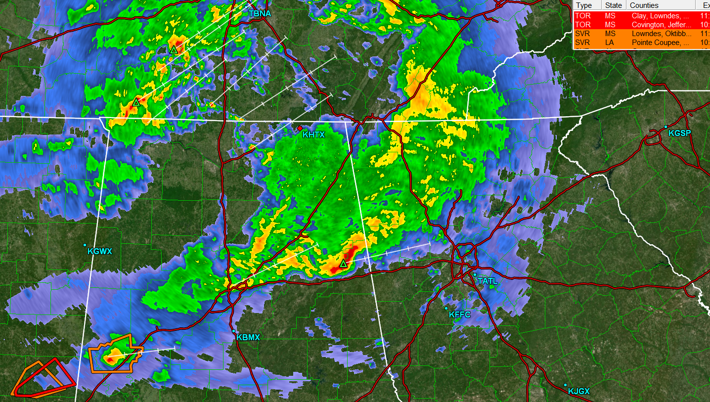
Tonight’s forecast takes us to an area under threat for severe weather. The strongest storms are in Mississippi, but northern Alabama remains in a slight risk for severe weather.

At 853PM, CT, Decatur was reporting cloudy skies and a temperature of 63 degrees. Low clouds and cool temperatures across northern Alabama suggest that the threat for severe weather is likely over, however, there is plenty of rain and thunder across central Tennessee that looms as a possibility overnight. Flash flooding is always a possibility, but the strong winds and tornadoes will remain to the southwest.
The parent area of low pressure associated with tonight’s storms is moving north of the Great Lakes, while a secondary vorticity maximum was centered over western Kentucky, providing the atmospheric spin, and emphasis on moisture importation to the region tonight. As a unit, this feature is progressing swiftly to the east, and the threat of rain should be clear of Decatur by sunrise. The high pressure that builds behind this system will be stout but transient. The next two days will be cool and clear, a recovery after a rainy and stormy night.
Tomorrow – Rain ending early, then becoming sunny, High 58, Low 30
Thursday – Sunny, High 52, Low 27

TWC: Tomorrow – Some clouds in the morning will give way to mainly sunny skies for the afternoon (early rain). High 62, Low 33
Thursday – Some clouds in the morning will give way to mainly sunny skies for the afternoon. High 52, Low 29

AW: Tomorrow – Cooler with clouds giving way to sun; breezy in the afternoon (Early Rain) High 60, Low 34
Thursday – Sunshine, High 52, Low 29

NWS: Tomorrow – Partly sunny, then gradually becoming sunny, (Rain early) High 67, Low 36
Thursday – Mostly sunny, High 51, Low 31

WB: Tomorrow – Much cooler, mostly sunny (Early rain), High 62, Low 33
Thursday – Partly cloudy, High 50, Low 30

WN: Tomorrow – Partly cloudy with showers and scattered storms, High 64, Low 36
Thursday – Partly cloudy, High 51, Low 32

FIO: Tomorrow – Heavy rain overnight and in the morning. High 63, Low 34
Thursday – Partly cloudy throughout the day. High 51, Low 29

Temperatures tomorrow will be falling through the day as high pressure settles in. Some rain looms to the northwest, but mercifully, none of it will bring terrible storms.

November forecaster of the Month

We are a couple of days from the end of the month, but with a handful of forecasts coming up, and a looming threat of severe weather coming tomorrow, I thought we might as well grab some time now to reward the top forecaster from the past month. The top spot this month belonged to the fine folks at the National Weather Service, who took the prize, thanks to good old fashioned consistency.

OutletForecast Wins (year)
Victoria-Weather7.82
National Weather Service7.66
Weatherbug7.33
The Weather Channel7.33
Accuweather7.32
WeatherNation5.33
Forecast.io4.16

Terrific weather by the Lake

If any one traveled around the western Great Lakes for Thanksgiving, you will be well aware that the weather was very good. In Racine, it was generally sunny, though with a few spots of clouds here and there for the two days before Thanksgiving, and it was warm. In fact, temperatures exceeded expectations on Wednesday, climbing all the way up to 55. Now that is something to be thankful for. Victoria-Weather navigated the low temperatures in Racine the best, which was the difference in our Turkey Day triumph.
Actuals: Tuesday – High 47, Low 24
Wednesday – High 55, Low 30

Grade: C

Midweek storm looming for the country

After a relatively docile November, the end of the month is going to provide quite a bit of climactic intrigue. Low pressure is already spiraling through the Rust Belt on it’s way to New England. It will make for a wet trek home from Thanksgiving for a lot of people, and even includes some rumbles of thunder in western Pennsylvania, and will likely bring snow to interior New England this evening.

This storm is a hassle, definitely, but a real show is massing in the northern Plains. The next trough is going to dip to the south and give rise to a strong area of low pressure developing in the middle of the country. Things will really come together on Tuesday evening, seemingly from nothing.

The center of low pressure will slide north of the Canadian Border on Tuesday, with a slow moving cold front extending from southern Minnesota to the Denver area, with snow showers expected along the boundary on Tuesday. As the feature shifts into Manitoba, things will really take off. Moisture will start flowing northward as the low taps into the Gulf, while an undercutting area of low pressure emerges in the mid Mississippi Valley. This will lead to some higher output snow bands on the northeastern stretch of the low. Some spots from southeastern Minnesota to the Upper Peninsula of Michigan will see 6+ inches of accumulation.

Also, with the atmospheric machinations and additional moisture, there is a looming threat for severe weather in the Lower Mississippi Valley. The undercutting low will produce a cold front of it’s own, and this will be the focal point for severe weather. Strong straight line winds are going to be a wide ranging problem, but the twisting and turning of flow in the region will also induce an seasonably high tornado threat.

The highest threat will be around sunset, just before and after, stretching from the Bootheel of Missouri to about Natchez, Mississippi. I would expect some supercellular storms in eastern Arkansas and northeast Louisiana, putting places like Monroe, Louisiana at risk for tornadoes. Things will aggregate into a line, bringing a more widespread straightline wind threat to western Tennessee and Mississippi, though embedded tornadoes are still going to be possible through the evening. The severe threat won’t last into the night, but rain and storms will be an issue in Alabama, Georgia and most of the eastern Seaboard on Wednesday.

The target area for severe weather is pictured below by the SPC.

It’s definitely going to be a nasty day for a lot of people on Tuesday, whether it be the snow in the north, the severe weather to the south, or the cold rain in between.

Turkey Day Travel Trouble Spots

We are two days before Thanksgiving, and if you are like me, and many people are, you are going to be traveling. The biggest travel period starts today, with return trips coming from Friday through the weekend.

Today and this afternoon, most of the country is going to be great for taking the trek to see family and loved ones. The exception is the Pacific Northwest, where a round of mountain snow and rain across Puget Sound could make any passages across the Cascades tricky. If you are in Seattle and have loved ones in Yakima, make sure to check conditions in Snoqualmie before you head out!

The rough weather in Washington will be short lived, though, and tomorrow looks even better for travel. There will be a bit of a return flow through the Red River Valley which may mean some light rain in Dallas, while the snow seen in Washington will diminish to just a few mountain flakes in the northern Rockies of Montana and Wyoming.

These two features portend a trickier trek home, however. The combination of low pressure emerging in the northern Plains and moisture arriving in the southern Plains are going to fuel rain and thunderstorms from the Piney Woods to the Lower Mississippi Valley by the time dinner wraps up on Thanksgiving. Storms could get a little heavy from Corpus Christi to Houston, so be on the look out deep in Texas.

Black Friday will be a gray Friday across much of the Lower Mississippi Valley. Persistent rain and thunderstorms will be possible from Louisiana to Mississippi and steadily increase eastward to Georgia and the Florida Panhandle. On the back side of this feature, I wouldn’t rule out some snow mixing around Lubbock and Lawton. On the north end, a cold front dangling from CAnada will move from northeast Minnesota and charge east towards the Great Lakes and ultimately land in New England by evening. It should be warm enough that rain will fall in the Great Lakes, but don’t be surprised to see snow in northern New England on Friday evening.

The low pressure bringing snow potentials to Texas will fill with warmer air, and tamp out the snow threat. Still, rain, heavy at times, will become increasingly likely through the mid Mississippi Valley eastward to Virginia, the Carolinas and Georgia. The steadiest wet weather right now seems to be seeking out St. Louis and Kansas City, but it’s too early to stake this forecast out as gospel truth.

This whole feature is going to really get ugly overnight Saturday into Sunday. It will start to draw on colder air from Canada and the Gulf Stream to ramp up rain and wind. Expect a very rainy start to Sunday from Cape Cod to the Delmarva as what is likely the year’s first Nor’Easter gets organized. Fortunately, it’s likely too warm to be a snow event, but the wind and cold rain will still be unpleasant enough. Rain falling on Buffalo may also lead to some urban flooding.

This system will blast through New England by the time night falls, fortunately, but it will leave behind that cold, windy weather that can only mean that the glad tidings of Thanksgiving are over, and winter is replacing autumn. Elsewhere, the travel period will end as it is starting: snow in the Cascades, but not much else.

Happy Thanksgiving to you and yours. Safe travels!

Lakeland, Florida to Racine, Wisconsin

Another trip home for the holidays. Lakeland is a new enough town that there aren’t likely to be many people FROM Lakeland, so this trip rationale seems right to me. It’s a 1,248 mile journey that will last two days, including a particularly long day on Wednesday to finish things off. Expect a pace of 66.4mph and a Tuesday covering 531.2 miles.

DAY ONE (Tuesday)

Lakeland, Florida

High pressure is taking care of the southeastern United States, and really, most of the rest of the country as well. Everything, except, ironically, the Sunshine State. A baroclinic flow is streaming across the Peninsula, and scattered showers and probably some embedded thunderstorms are going to be possible until Gainesville, with isolated spots of precipitation as far north as Macon. Fortunately, the drive through Atlanta will be nice and dry. We’ll get into Dalton, just south of Chattanooga, for the night.

DAY TWO (Tuesday)
There will be a bit of a return flow through the middle of the country, which will bring temperature and humidity up a little bit. It won’t be an exquisitely sunny day but the whole way to Racine will be dry and pretty easy to navigate. You might even enjoy a trip to the lakeshore after reaching Racine.

Racine, Wisconsin

Racine, Wisconsin

Today’s forecast takes us to southeastern Wisconsin. Thanksgiving week in the Midwest seems appropriate.

At 1053AM, CT, Racine was reporting a temperature of 40 degrees with clear skies. An area of low pressure over eastern Canada was inducing a strong west wind across Wisconsin, which made things feel cool, but the off shore breeze allowed temperatures to reach 40 and ensured that clouds stayed over Lake Michigan.
The wave over Canada will be replaced by weak low pressure in the Canadian Prairies. The change in pattern will tamp down on the gusty winds, and the change in flow around the next area of low pressure will bring about some southerly flow, and warmer temperatures for mid-week.
Tomorrow – Mostly sunny, High 44, Low 23
Wednesday – Partly cloudy, High 48, Low 30

TWC: Tomorrow – Sunny along with a few clouds. High 44, Low 26
Wednesday – Mostly sunny. High 49, Low 27

AW: Tomorrow – Mostly sunny; quiet weather for early holiday travelers High 45, Low 28
Wednesday – Sunny to partly cloudy High 50, Low 29

NWS: Tomorrow – Sunny, High 44, Low 25
Wednesday – Sunny High 49, Low 27

WB: Tomorrow – Partly sunny in the morning, then clearing, High 43, Low 25
Wednesday – Sunny, High 47, Low 30

WN: Tomorrow – Mostly sunny, High 42, Low 27
Wednesday – Mostly sunny, High 48, Low 31

FIO: Tomorrow – Partly cloudy throughout the day. High 43, Low 28
Wednesday – Partly cloudy throughout the day. High 48, Low 31

Check out the satellite of the Great Lakes. The westerly flow is leading to a cloudy day in Michigan, but not in Wisconsin.

Nicole holds up her end of the bargain

A strong cold front moving into the middle of the country started us on a weeklong cold snap that afflicted a sizeable tract of the country. It brought heavy rain to the High Plains, but it dwindled as it progressed eastward. There was only about a tenth of an inch of rain in Jefferson City on the 11th, but it diminished from the heavy rain seen west of there thanks to Hurricane Nicole. Nicole was moving inland at the same time the cold front was passing through Missouri, and at the same time, intercepting a lot of the moisture that would have fallen on the Show Me State. It didn’t slow down the cool down, though, because it sure got chilly on the 12th! Not as chilly as the forecast said, though, which gave the shared victory to The Weather Service and Weathernation.
Actuals: November 11th, .11 inches of rain, High 49, Low 32
November 12th, High 32, Low 29

Grade: C

Buffalo getting pounded by several FEET of snow

The beginning of winter and the approach of spring are tenuous times for the Great Lakes. With a cold November interacting with yet unfrozen lakes, all it takes is a persistent wind to lead to some particularly impressive snow totals. Suburban Buffalo is in the crosshairs for those kinds of numbers.

The snow is supposed to be heavy enough and at such a time that due to safety concerns for he fans, the Buffalo Bills home game has been moved to Detroit for the weekend. Orchard Park, home of the Bills, is south of that 21.4″ forecast in the city of Buffalo, and could be inline for nearly 3 more feet of snow. (This forecast is for snow on top of what has already been received.)

What is wild about this, is the synoptic outlook for the region, and really the country. Sure, there is low pressure in eastern Canada driving the west-southwest flow off of Lake Erie but there isn’t a lot of atmospheric moisture attendant to the feature.

Buffalo, and Watertown in the same position, just northeast of Lake Ontario, are simply in the wrong place, withstanding a full fetch off their respective Great Lake. Fortunately, much of the rest of the country, excepting the Gulf Coast, where rain is likely tonight, is headed for a pretty quiet travel weekend. Unless you are heading to Buffalo.