April is right around the corner, and it seems as though we will be entertaining northeast Ohio regularly to start things off.
Canton, Ohio
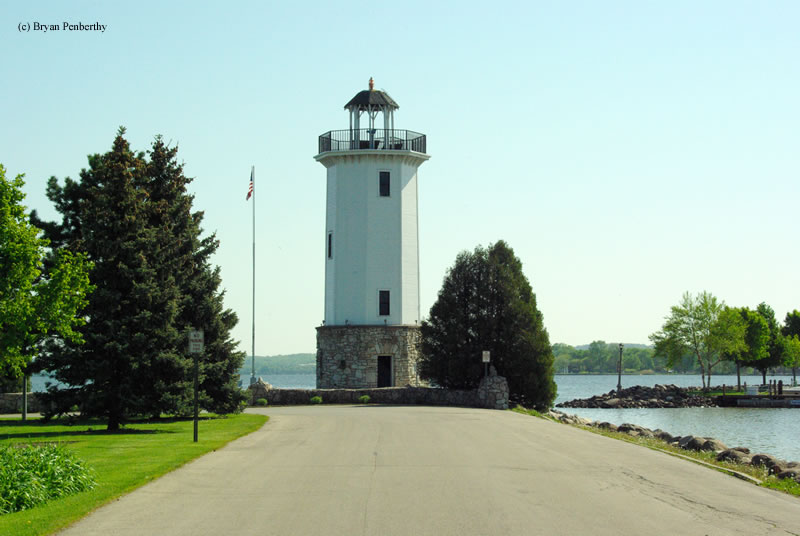
Pine Bluff, Arkansas
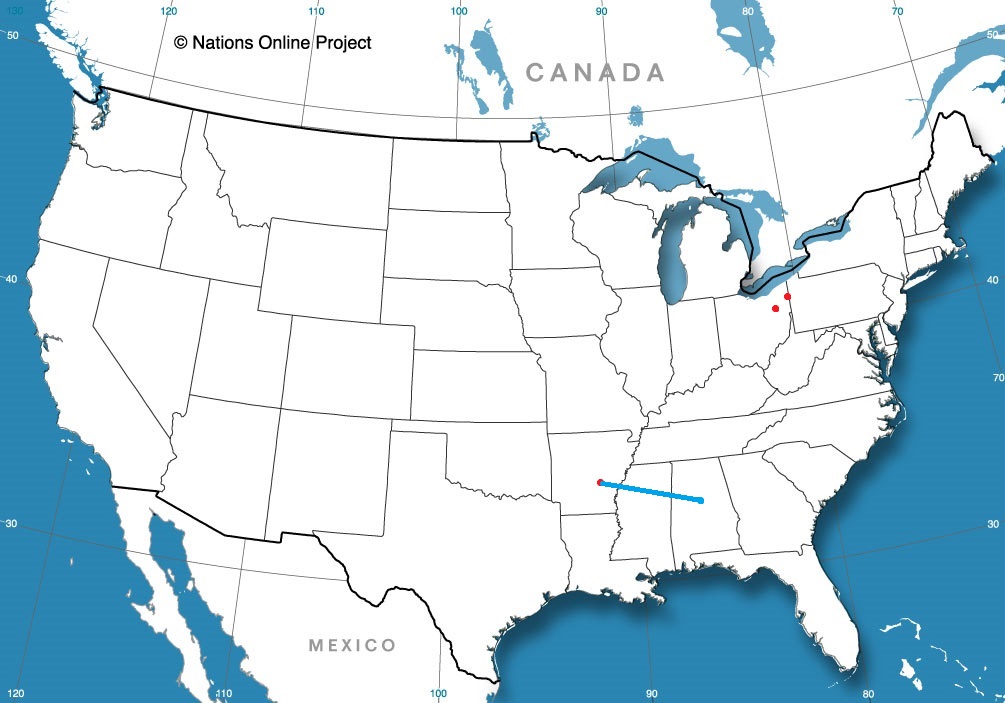
Road trip from Birmingham, Alabama to Pine Bluff
Youngstown, Ohio
from Victoria-Weather

April is right around the corner, and it seems as though we will be entertaining northeast Ohio regularly to start things off.
Canton, Ohio
Pine Bluff, Arkansas
Road trip from Birmingham, Alabama to Pine Bluff
Youngstown, Ohio
What was presently evaluated to be an EF-4 tornado swept through western Mississippi on Friday evening, striking Rolling Fork and Silver City. The cell continued and another tornado struck near Winona at an EF-3 rating. In total, these tornadoes were responsible for the deaths of at least 20, most of whom were from Rolling Fork.
The Jackson, Mississippi NWS office is among the best in the country, in my pinion, and they were well ahead of this storm. There was a tornado emergency issued for Rolling Fork and Silver City before the storm struck, with ample advanced warning. Rolling Fork lies well removed from other large population centers, in an impoverished part of Mississippi, and the ability for the message to be disseminated, and the swiftness of emergency response may be factors in the elevated death toll.
Undoubtedly, the structural integrity of many of the building in Rolling Fork, Silver City and Winona were factors, and the strength of the tornadoes themselves absolutely cannot be discounted. This storm, like so many before it, however, underscore the systemic issues that can increase the lethality of a system, and emphasize how important it is to have a plan for severe weather before it is on your doorstep.
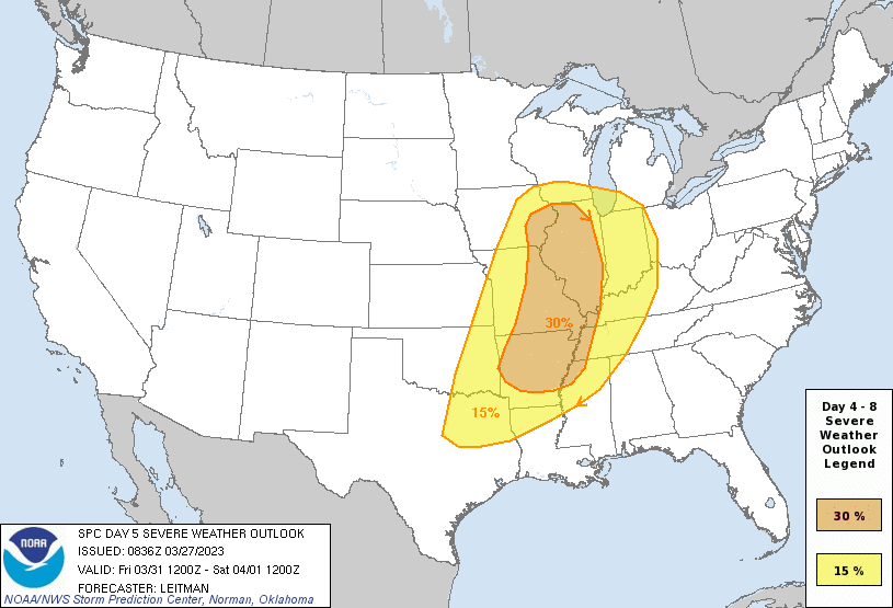
With that in mind, there is certainly more rough weather on the horizon as we get deeper into springtime. The SPC is already monitoring Friday the 31st for a significant severe weather outbreak. They highlight a large tract of the country straddling the Mississippi, and I would, at this early stage, be particularly interested to see how the situation evolves around the Bootheel of Missouri.
The storm is going to be reflective of so many that have struck this winter. A deep diving trough will initiate rapid cyclonic development in the southern Plains, lifting north towards the western Great Lakes. Vorticity within the feature will lead to a tornado threat within the northern part of the storm, though strong wind and some hail are going to be an issue as well.
If you are in line for this severe weather, it’s time to have a plan. Even if this storm might leave you unaccosted, with severe weather season coming for the country, it’s a good idea for all of us to start considering what we will do in the event of a life threatening situation.
An important part of the winter cycle in the north is the storage of water in the snowpack that will sustain and help nourish the first buds of spring time. It has been a warm, dry winter in the mid-Atlantic, so the next best thing is rain, like what fell on St. Patrick’s day in Utica. They received over a half an inch of rain, with a mostly inconsequential spot of flurry activity on the Saturday after. Usually the rainy systems with changing precip types are calamitous in the temperature forecast, but perhaps with a bit of the luck of the Irish, forecasts were quite good all around. The National Weather Service gained the W.
Actuals: March 17th, .58 inches of rain, High 45, Low 32
March 18th, .05 inches of liquid in snow, High 38, Low 25
Grade: A-B
It feels like Dothan is home to many forecasts in our history. If that’s the case, then this should be a slam dunk, right?
At 1153AM, ET, Dothan was reporting a temperature of 61 degrees. A thick, anomalous splotch of overcast was situated over southeastern Alabama and the surrounding bits of Florida and Georgia, keeping temperatures in Dothan, Enterprise and the surrounding environs several degrees off the pace of other nearby locations. Flow was generally southerly, though dew points were still quite comfortable, with a lingering cold front from the southern Great Lakes to the High Plains, with more development to follow.
The cold front will stall over the Ohio Valley through the day on Thursday, leading to some warmer temperatures in Dothan. With a broad slow moving trough in the western US, the central Mississippi Valley will be ripe for development. An area of low pressure will develop over St Louis and encourage the southerly flow, making for an even warmer day on Friday.
Tomorrow – Mostly sunny, High 81, Low 55
Friday – Sunny, High 84, Low 58
TWC: Tomorrow – Areas of patchy fog early. Some clouds in the morning will give way to mainly sunny skies High 83, Low 53
Friday – Areas of patchy fog early. Sun and a few passing clouds High 84, Low 60
AW: Tomorrow – Intervals of clouds and sunshine; start of a period of much warmer weather High 84, Low 53
Friday – Partly sunny and breezy High 83, Low 59
NWS: Tomorrow – Widespread dense fog, mainly before 8am. Otherwise, mostly cloudy through mid morning, then gradual clearing, High 82, Low 54
Friday – Patchy fog before 9am. Otherwise, mostly cloudy, then gradually becoming sunny, High 83, Low 58
WB: Tomorrow – Mostly cloudy in the morning, then clearing. Areas of fog in the morning, High 80, Low 53
Friday – Partly sunny in the morning, then clearing. Patchy fog in the morning. High 82, Low 58
WN: Tomorrow – Partly cloudy, High 82, Low 54
Friday – Mostly sunny, High 83, Low 58
CLI: Tomorrow – Sunny, High 82, Low 52
Friday – Partly cloudy, High 83, Low 57
Here you can see that splotch over Dothan, remnant from some morning fog. It’s probably going to settle back in tonight.

Fond du Lac was seeing the last few flakes of a weak snow system when we issued their forecast a week and a half ago. It snows in March, that’s not unusual. In fact, March is one of the snowiest months of the year for the north central US. What was unusual was that on Tuesday, temperatures dropped down to single digits, well below normal. Victoria-Weather had a chilly outlook, securing the victory for the home team.
Actuals: March 13th, .07 inches of liquid in snow, High 29, Low 19|
March 14th, High 31, Low 7
Grade: A-C
Well, that didn’t take long. The new outlets we cycle in are not generally that successful. I’m not sure Weathernation has ever won. Clime, however, won in only their second month on the job. After an auspicious start to the year, they have steadily improved and were able to take the second title of the year, and so far, have the highest individual forecast total of all of our outlets.
| Outlet | Forecast Wins (year) |
| Clime | 1.5 |
| Victoria-Weather | 1 |
| National Weather Service | 0.5 |
| Weatherbug | |
| Accuweather | |
| The Weather Channel | |
| WeatherNation |

Our first forecast in the month of March went pretty well, frankly. There was a late developing, potentially virulent storm headed towards the Great Lakes that lead to an array of precipitation forecasts in Michigan City. In the end, on March 9th, Michigan City saw precipitation in the evening, which changed to all snow quite quickly. This happened sooner than anticipated, but it wasn’t doom and gloom for most of the forecasts, at least those that called for precipitation. The temperatures were baked in before the precipitation was expected, so for those that called for rain, the forecast worked well. Victoria-Weather started the month with a W.
Actuals: March 8th, High 46, Low 30
March 9th, Trace of precipitation, HIgh 43, Low 32
Grade A-C
On this, the first day of the round of 64 in the NCAA tournament, we go to Utica, a town that sure sounds like a college town. Alas, they are not home to any Division 1 universities, but they are situated in the scenic Adirondacks.
At 153PM, ET, Utica/Rome was reporting a temperature of 43 degrees with overcast skies. The temperatures have bounced back nicely in the wake of the first real nor’easter of the season, however the climb in temperatures is aided by another system developing in the Mississippi Valley. Southerly winds will continue through the mid Atlantic today, bringing even more warm air to Utica, continuing what has been a very toasty winter season, though at this point in the year, and this system in particular are quite spring like.
The storm is responsible for severe weather in the Red River Valley that will become more widespread this afternoon. Of more pertinence to the Utica region is the sloppy mix in the Northern Plains. As most systems do, this feature is starting its poleward motion, and at this time even the northern flank of this feature is mixing with rain. This suggests that warmer air will pull further north, and as the system moves through, Utica can expect an all rain event tomorrow. The rain will be fairly light with a dry slot nosing into the Adirondacks, and temperatures will fall off on Saturday as the cold air arrives. By that point, most of the moisture will have pressed into Canada, and a chilly breeze will be more noticeable than the few flakes in the evening.
Tomorrow – Scattered showers, High 44, Low 32
Saturday – Chilly and breezy with a little bit of flurry activity late, High 35, Low 24
TWC: Tomorrow – Rain, High 45, Low 30
Saturday- Mostly cloudy. Snow showers around in the afternoon. High 37, Low 30
AW: Tomorrow – Periods of rain, High 47, Low 32
Saturday – Mostly cloudy with a couple of snow showers; any heavy snow shower could cover the ground quickly and reduce visibility High 40, Low 26
NWS: Tomorrow – Showers, mainly after 9am High 45, Low 31
Saturday – A chance of snow showers after 3pm High 37, Low 25
WB: Tomorrow – Rain showers with freezing rain likely in the morning with rain showers in the afternoon, High 42, Low 32
Saturday – Partly sunny in the morning then becoming mostly cloudy. A 40% chance of snow showers, High 36, Low 24
WN: Tomorrow – Mostly cloudy with showers, High 45, Low 31
Saturday – Windy with snow showers possible, High 35, Low 29
CLI: Tomorrow – Drizzle, High 45, Low 32
Saturday – Light snow, High 39, Low 23
More wet weather is on the way for Utica. It seems pretty ok for now, but the next feature looms.
We’re going to start the week with what should be a pretty quick jaunt. It won’t be, because we will be navigating the Chicagoland region, but it definitely SHOULD be. The drive will be nearly 3 1/2 hours, at a glacial pace of 63mph.

A weak little wave is moving through the Great Lakes this evening, and it will generally be in the central and eastern Great Lakes before the drive begins on Monday. I don’t think there will be much in the way of flurry activity south of Lake Michigan, though it can’t be ruled out, especially in Michigan City and Laporte. I would expect some dryer skies through Chicago proper, but as we approach Waukegon and north through Milwaukee, I would expect flurries to pick up again. This weak little feature is wrapping in a considerable amount of light snow that just doesn’t want to cut out, so I have to believe it will still be snowing in Fond du Lac when we arrive. Nothing accumulating, but it will be happening.
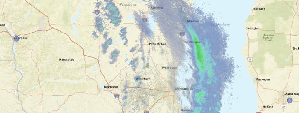
We’re headed to eastern Wisconsin for our forecast this afternoon. Eastern Wisconsin is a well populated region, but Fond du Lac is interesting in that it is offset from Lake Michigan, along with Appleton, on Lake Winnebago. The weather is bound to be different than Green Bay or Milwaukee.
At 253PM, CT, Fond du Lac was reporting a temperature of 36 degrees with overcast skies. A lingering winter weather advisory was still out for Fond Du Lac, but the thrust of the precipitation was already falling over Lake Michigan. Circulation associated with this system was centered just to the west of Wausau, and though the bulk of the snow is out of the region, light flurries are expected to persist in America’s Dairyland overnight and into the wee hours tomorrow morning.
After that, the short wave leading to the snow in the area today will continue towards the easter Great Lakes, and a narrow but stout ridge of high pressure will set up in the Upper Midwest and move east into Wisconsin. As a result, Monday afternoon and the day on Tuesday will be seasonably pleasant.
Tomorrow – Snow early, then clearing and cooling, High 29, Low 20
Tuesday – Sunny, High 31, Low 11
TWC: Tomorrow – Cloudy (early snow), High 29, Low 22
Tuesday – Mostly sunny, High 29, Low 10
AW: Tomorrow – Mostly cloudy with flurries; breezy in the morning, then becoming chilly High 31, Low 22
Tuesday – Plenty of sunshine, but chilly High 32, Low 11
NWS: Tomorrow – Snow likely, mainly before 7am, then a chance of flurries after 2pm. Mostly cloudy, High 29, Low 21
Tuesday – Sunny High 29, Low 10
WB: Tomorrow – Mostly cloudy. Chance of light snow in the morning, then chance of flurries in the afternoon, High 29, Low 24
Tuesday- Sunny, High 29, Low 14
WN: Tomorrow – Mostly cloudy with light snow showers, High 29, Low 20
Tuesday – Mostly sunny, High 29, Low 10
CLI: Tomorrow – Light snow showers, High 28, Low 19
Tuesday – Sunny, High 28, Low 12
The threat for snow is going to be more of the nuisance variety, but it will be persistent. The threat of this forecast is the pending cold to start the week.