Watch out, world, here we come. We’re back to a few posts a week, we might even have some days with more than one post in a day, and not just today! Ironically, it will likely take my being snowed in to get there. Oh well.
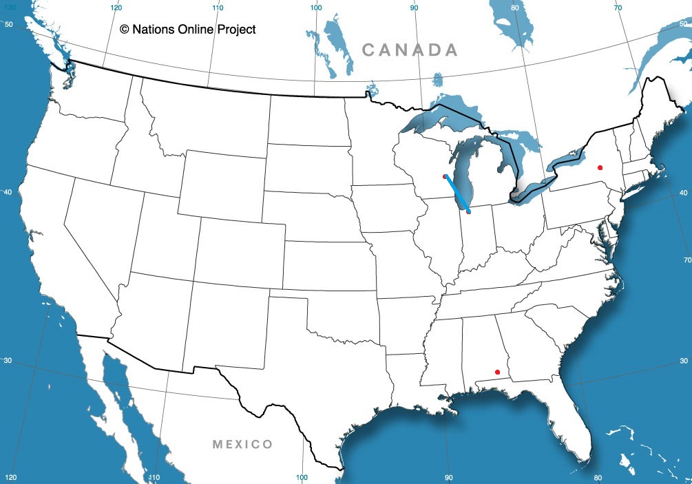
Michigan City, Indiana
Fond du Lac, Wisconsin Road trip from Michigan City to Fond du Lac
There is a huge, multiphase storm moving across the country. Essentially, only areas from the Mid Atlantic to Florida are going to be spared. There will be blizzard conditions in the north, severe storms through the middle of the country, and even snow squalls in the 4 Corners. It is brutal, and it’s continuing to go down hill. I am telling you this so you can look to the National Weather Service, who had the best start to the forecasting year, and are your January forecasters of the month.
Boy, we know when to pick these cross country trips. This trip, into the teeth of one of the most significant storms for the Upper Midwest in decades, will last 4 days in ideal conditions, though these will be less than ideal. It’s 2065 miles between the systems, and right now is prognosticated to have a pace of 66.6mph, which will lead to a perhaps aspirational 533 miles a day. Day 4 will be a hair shorter than the rest, but they are all going to feel long, I reckon.
DAY ONE (Tuesday)
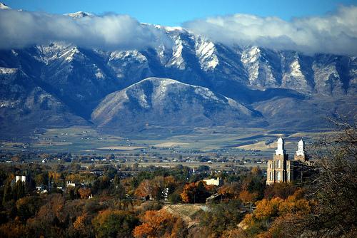
Logan, Utah
The entirety of our route on Tuesday will be in a at least a winter storm warning, while some stretches of southern Wyoming are in a blizzard warning. I think the heaviest snow will be in Montana tomorrow, though we will be seeing snow around Logan as we set forth. Wind will be on the increase throughout the day, but we will probably be dry from time to time from Kemmerer to Rock Springs, then even more sparsely through the remainder of the state of Wyoming. Assuming we keep our pace, we will be just ahead of the worst of the snow, but any flurries we see will be wind driven and challenging. The day will end in Sidney, in the Nebraska Panhandle. Batten down the hatches, it is going to be a long night.
DAY TWO (Wednesday) This is definitely our most imagination driven day. The heavier snow is going to sink south into Nebraska, along with a cold frontal wind, and it is not out of the question that blizzard conditions will grip most of I-80 in Nebraska. If that’s the case, then the road might simply be closed. The nasty parts of the storm will be cut off by a dry slot nosing north into the Omaha and Nebraska City regions, and we might even get some dry air after we leave the freeway in Lincoln. Expect to see drier condition as we head south, west of a cold front that will, by this point, have advanced into Iowa and Missouri. We will end the day in Kansas City, and be extremely grateful for it.
DAY THREE (Thursday) The nasty storm is going to focus it’s wrath to our north by Thursday, which is good news for our travels, bad news for the Great Lakes. South winds will be rushing north to meet that area of low pressure, and especially east of St. Louis, we will need both hands on the steering wheel, as if they haven’t been white knuckling the whole way already. We’ll make it to Simpsonville, east of Louisville, by the end of this day.
DAY FOUR (Friday) Low pressure will be moving vaguely poleward by the end of the week, and this is a relief for us. Dry skies will continue on the way to Greensboro, though a little band of light rain will develop eventually to our south and west, and that wind that will buffet us on Thursday will also be a memory. The arrival in Greensboro will come after 4 long days of driving, and will be quite a relief.
The winter track has not been kind to the low country of the Carolinas this year. It’s been quite dry and warm in the eastern Carolinas and a drought, not quite as severe as other parts of the country, has been building. Might we finally get a soaking of rain in North Carolina? Greensboro, in particular?
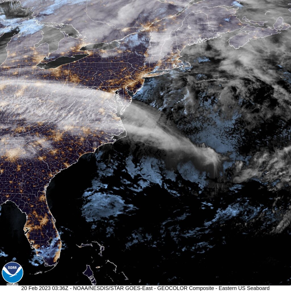
At 954PM, ET, Greensboro was reporting cloudy skies and a temperature of 48 degrees. Most of the Tar Heel State was reporting clear or fair skies, but Greensboro was under a high overcast. Greensboro’s observation reflects the satellite a bit more accurately, as a feather of clouds is seen extending from the Atlantic through Viginia and on to the Ohio Valley. This is extended from low pressure now headed for Greenland, and following a strong jet streak, running west to east through the region. Temperatures are expected to remain on the warm side in Greensboro to start the work week. A pulse moving through the northern Great Lakes will connect a warm front through a secondary trough moving behind the offshore front, and will touch off some mountain showers in Virginia and western North Carolina. More high overcast is anticipated in Greensboro on Monday afternoon. The real show will be massing in the High Plains. Warm air is going to start rushing north on Tuesday ahead of this feature, with temperatures beginning to rise, even among the layered clouds across the region. Tomorrow – mostly cloudy, High 65, Low 42 Tuesday – Mostly cloudy, High 71, Low 49
TWC: Tomorrow – Cloudy. Slight chance of a rain shower. High 64, Low 44 Tuesday -Partly cloudy, High 72, Low 51
AW: Tomorrow – Times of clouds and sun with a shower in places in the afternoon High 62, Low 45 Tuesday – Mostly cloudy; a shower cannot be ruled out High 70, Low 49
NWS: Tomorrow – A slight chance of rain after 1pm. Cloudy High 62, Low 44 Tuesday – A slight chance of rain. Partly sunny, High 71, Low 51
WB: Tomorrow – Cloudy, a slight chance of rain in the afternoon, High 60, Low 44 Tuesday – Partly sunny with a 20 percent chance of rain. High 71, Low 52
WN: Tomorrow – Mostly cloudy with isolated showers, High 62, Low 44 Tuesday – Partly cloudy, High 71, Low 51
CLI: Tomorrow – Light rain showers, High 61, Low 43 Tuesday – Partly cloudy, High 69, Low 48
I think with the lack of moisture in the area, the ongoing dry, and the warm temperatures, rain just doesn’t ring true to me as a worthwhile forecast. I’ll probably be wrong! Hope I am. Here is satellite, with that feather of clouds in the mid-Atlantic.
It’s been a rough winter for snow fans across a great deal of the country. Sure, here at Victoria-Weather HQ, we have been buried in snow, with more on the way, but even just as far south as Des Moines or east in Indianapolis, the winter has been paltry. So the snow that was received in Indianapolis back at the end of January, while it only accumulated to 1-4″ of snow in the metro, it was the biggest storm they’d seen to date or since in many spots. Fortunately, my misgivings about Clime were for naught, as they tied for the top spot with the Weather Channel. Actuals: January 25th, .73 inches of liquid in rain and snow, High 38, Low 32 January 26th, .11 inches of liquid in snow, High 32, Low 24
Areas of low pressure rotate counter-clockwise, dragging air around them in such a pattern. When all things are equal, in the Northern Hemisphere, warm air rises from the south on the eastern flank of a low, and cold air sinks south on the western flank. There are some undulations, notably with topography and the presence of large bodies of water that modify this scenario in some locations, but more or less, that is how it works.
The most nefarious of our weather comes as the cold air tries to intersect with that warm air, all while the atmosphere is trying to rotate. There are updrafts caused by the cold digging in, latent buoyancy of the warmer air, and the twistiness of the wind pattern. This can mean rain, thunderstorms or even heavy snow. This is why the northern Plains can get wicked blizzards, and the Southern Plains and increasingly the lower Mississippi Valley are prone to strong thunderstorms and tornadoes.
We’ve already seen a busy start to February, with severe weather afflicting the Lower Mississippi Valley, and copious snows falling from Kansas to Iowa, though the southern Great Lakes. Temperatures, as you might imagine, have been fairly warm in the eastern US, with an unusual chill out west. Before these past few days, the cold was aided in part by Pacific systems coming ashore, bringing clouds and rain. Now, it’s simply a colder air mass.
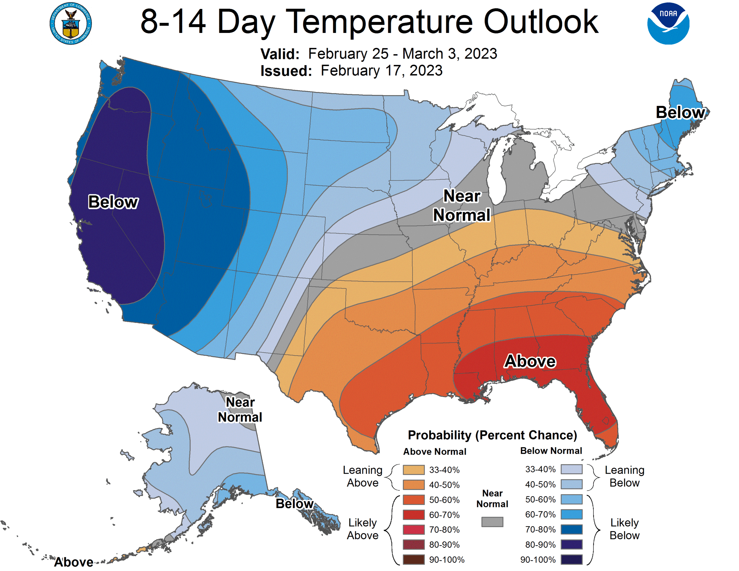
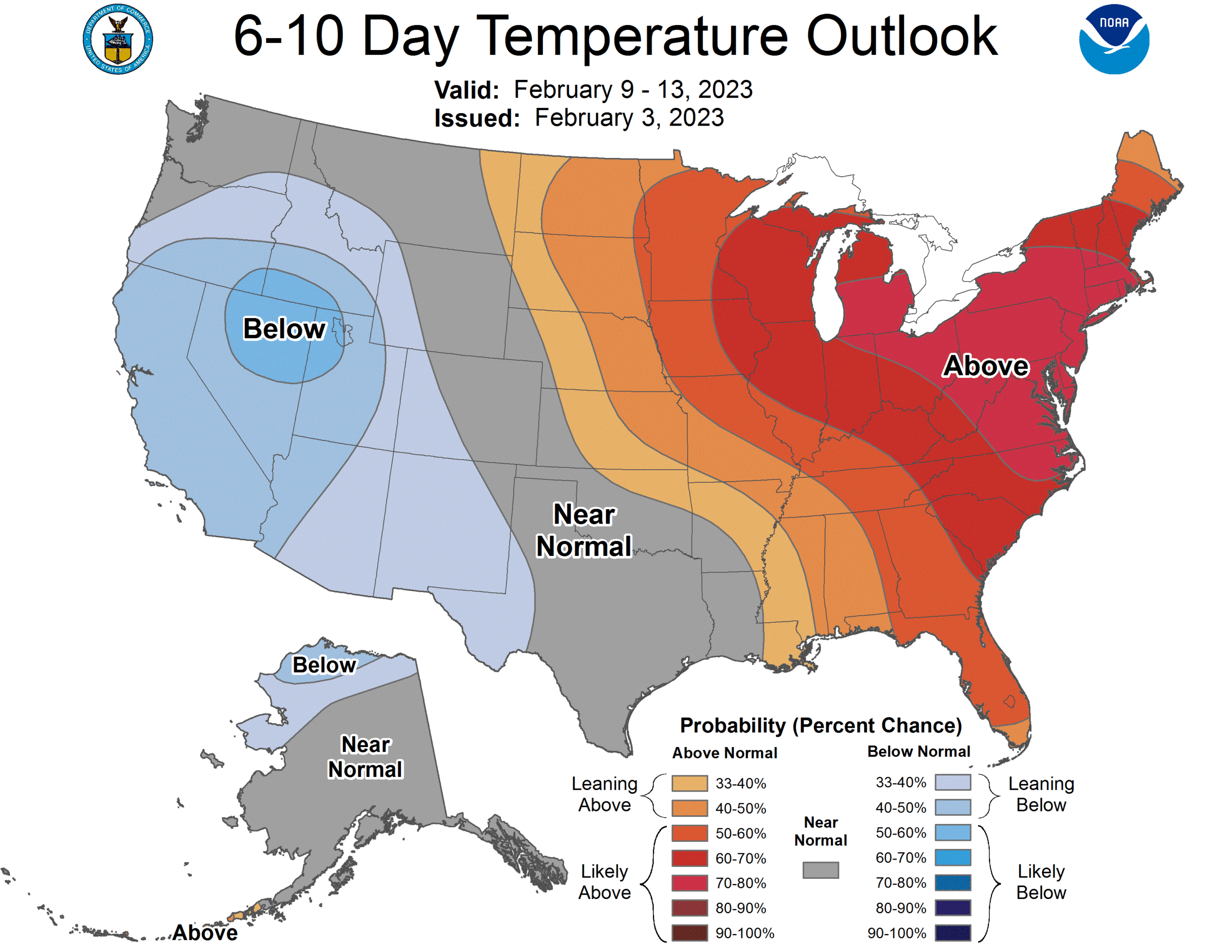
Knowing that it is the clash in air mass that fuels stronger weather, and particularly when the clash is between western cold and southeastern warmth, the long term out look suggests action to come.
Whether in response to persistent lee troughing in the High Plains, or a result of a static jet pattern, this temperature trend for the end of the month and beginning of March indicates some busy times, both for tornado chasers centered in the middle of the country, and snow plows in the Upper Mississippi Valley.
In the Upper Midwest, the story of the winter has been the snow. Several rounds of accumulating snow have buffeted the Twin Cities, but temperatures have always rebounded, because the responsible storms are bringing moisture from the Gulf, rather than cold air from the north. That is changing with a series of Clippers that moved through last weekend.
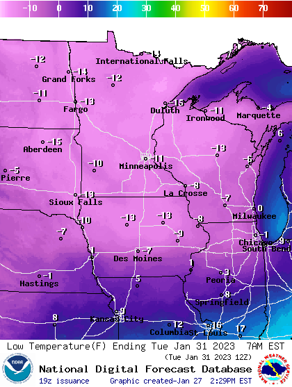
Temperatures in Minnesota ahead of the cool down were in the 30s and seasonably pleasant, but they are going downhill, and the low temperatures will reach all the way to Chicago and the western Great Lakes by Tuesday morning. This was the forecast for Tuesday morning in the Upper Midwest.
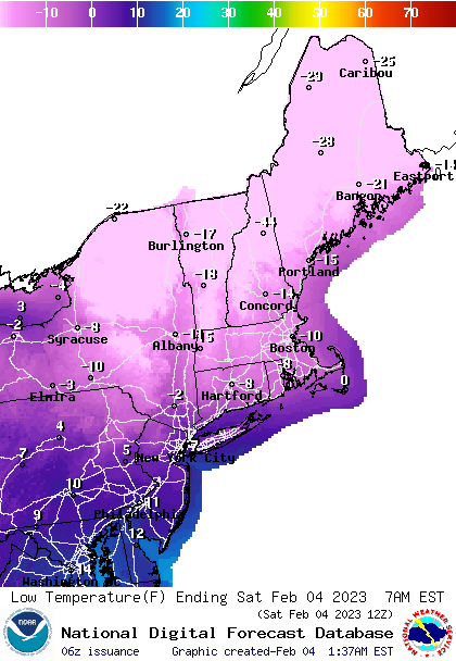
That cold has stuck around, and while it was chilly Tuesday, a reinforcing shot of the cold air came this morning, and it was as cold as -35 in International Falls, Minnesota. Unlike the initial rounds, this cold air is pressing further east, and while the Twin Cities and Minnesota are warming this weekend, it’s going to be dangerously cold in New England.
And unlike the cold in the Upper Midwest, there is a deep area of low pressure northeast of the Canadian Maritimes, bringing a brisk northeast wind, not only reinforcing the cold air, but introducing significant wind chill. Boston could see a wind chill of -30 in the early hours.
Great news, though. While this cold, the coldest shot of the winter in a lot of places, and in parts of New England the coldest in a decade, is brutal, it’s reign is at an end. Next week is forecast to be much warmer than normal for many locations in the chill this week.