The verification for Kennewick sure was humbling. It wasn’t the case in San Antonio, however, as departing clouds and a little bit of exiting drizzle left the city with mild, almost cool conditions for a couple of days… just like we expected. Temperatures were a hair lower than what was in the forecast, but the high of 71 both Sunday and Monday was pretty close to what we all expected. The Weather Channel and Accuweather claimed a shared victory. Actuals: Sunday – High 71, Low 43 Monday – High 71, Low 40
November is coming to a close, and we are reaching the final month of 2021. We’ll welcome the month with a 3 day road tri from the Garden State to the Lone Star State. It’s going to be a 1790 mile journey, at a 66mph pace, or for 530 miles on days one and two, with a long drive through the heart of Texas on Friday.
DAY ONE (Wednesday)
Atlantic City, New Jersey
The train of systems moving through the country right now is following a Canadian track. There are little lobes of low pressure swinging south towards the Great Lakes, bringing rain and snow there, but that moisture doesn’t appear likely to traverse the Poconos, and we will head through the Mid-Atlantic with some high cloud cover, but it won’t be a bad day by any stretch of the imagination. We’ll make it to southwestern Virginia after our fist day, stopping in Chilhowie, which is about half an hour from the Tennessee border.
DAY TWO (Thursday) Low pressure will continue to barrel through Canada but is getting stronger and more well organized, preparing to doink New England just before the weekend. Some moisture will continue to dangle as far south as the high terrain of West Virginia and Virginia, but it should be ok in Chilhowie. As we traverse Tennessee the long way, we will enjoy good driving conditions and a lot of sun. We’ll end up in te northern suburbs of Memphis to end the day.
DAY THREE (Friday) As warm high pressure moves into the southeastern US, we are looking at a positive start to our Friday drive. The ridge moving east will bring about some return flow on the west side of the ridge. This moisture rich flow will probably not result in showers or storms, but that is a possibility that can’t be discounted south of Hillsboro and into San Antonio. Expect some haze and fog overnight when we reach San Anotnio, and the soupy atmosphere I think we all thought we left behind.
Every time I think of San Antonio, I find it is in a much further south location than I remember. It’s a big city that is totally different than any of the other big Texas towns.
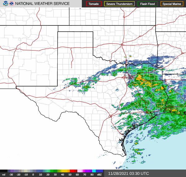
At 951PM, CT, San Antonio was reporting overcast skies with a temperature of 51 degrees. Dew points were nearly 50 degrees across the region as well, and some early fog was settling into the region. Low pressure had become established just offshore from Texas, and was helping to generate heavy rain in East Texas, with something resembling a feeder band arcing around towards Amarillo and Lubbock. The low was developed near the right entrance of a jet streak, and at the tail of a surface trough, and is not tropical in nature. As the jet shifts away, the low will disintegrate into the Gulf, while high pressure develops in the southern US. The surface pressure ridge will be transient, though upper level support will remain in place. Westerly flow across the southern Rockies will allow some additional warmth to spread across the region to begin the work week. Tomorrow – Morning clouds and fog, followed by a nice afternoon, High 68, Low 48 Monday – Sunny, High 73, Low 44
TWC: Tomorrow – Sunshine and clouds mixed High 71, Low 46 Monday – Sunny skies. High 72, Low 44
AW: Tomorrow – Warmer with times of clouds and sun; ideal weather for one of the busiest travel days of the year High 70, Low 46 Monday – Comfortable with plenty of sunshine High 72, Low 43
NWS: Tomorrow – Mostly sunny, High 68, low 47 Monday – Sunny High 70, Low 44
WB: Tomorrow – Not as cool, Partly cloudy, High 67, low 46 Monday – Sunny, High 70, Low 43
WN: Tomorrow – Partly cloudy, High 68, Low 47 Monday – Mostly sunny, High 70, Low 44
FIO: Tomorrow – Partly cloudy throughout the day. High 69, Low 46 Monday – Clear throughout the day. High 72, Low 43
Quite a bit of rain is showing up on radar, but none of it looms for San Antonio.
All right, everyone, we’ve got a road trip coming. The drive from Anniston to San Antonio will cover a day and a half and 923 miles. We’ll net around 542 miles on our full day at a pace of about 67.8mph, and having a big day of Texas driving to finish things off.
DAY ONE (Wednesday)
Anniston, Alabama
Things are looking pretty good for the southeast, thanks to a boundary implanted in the southern Gulf. Precipitation won’t be able to filter south as far as Anniston, or really any part of our route. It will be uncharacteristically cool in Alabama or Mississippi, and you will probably find people in Egan, Louisiana, the destination for Wednesday night, in layers when we arrive.
DAY TWO (Thursday) Surface high pressure is going to drift further to the east on Thursday, and for the first time this season, as far as I remember, a moisture rich return flow will follow the west end of the ridge. Some showers and low clouds will drift into central Texas fairly early in the day. Most noticeably when we step out in San Antonio, the humidity will have arrived.
Everything is bigger in Texas, or so they say. The temperature readings were pretty huge in San Antonio on the 19th and 20th, with the highs reaching triple digits on the 19th, and the upper 90s on the 20th, all while failing to dip below 80 for the overnight lows. That is a big time heat wave. Forecasts all circled the same numbers, so there wasn’t much separation, but a nearer high on the 20th gave Weatherbug the victory. Actuals: August 19th – High 100, Low 80 August 20th – High 97, low 80
We are going to head right into the heat here in the dog days of summer. There will be a point where we have to pass through some storms to get from moderately more tranquil weather in New England to the steamy south, but where will it happen along our 2013 mile journey? And when, over the 4 day trek? As you might be able to establish, we will cover a bit more than 500 miles a day (519, actually) while traveling at a pace just shy of 65mph, which is somewhat slow, thanks to the tangled web of the east coast, and not a fear of impending thunderstorms.
Providence, Rhode Island
DAY ONE (Tuesday) Naturally, the feature first expected to impact our journey will be a weak shortwave trough moving out of the Great Lakes. Why is this great? Because I’m being sarcastic, and this will be difficult to forecast around. There is consensus that we will be dry through the New York City area, but then it becomes a little dodgier. I think the model that brings a lot of rain to Pennsylvania is doing so because of poor resolution. I think it’s going to generally be mostly cloudy with some isolated spots of rain, but maybe not enough to even turn the wipers on. These dots will be possible for the rest of the journey, though becoming less likely as we pass into Virginia. The day will end in New Market, Virginia, in the northern part of the state.
DAY TWO (Wednesday) Another wave moving into the Great Lakes is going to carry with it a bit more weight. Inflow towards the low might lead to some fog and haze in the Appalachians and Smokey Mountains, but the potential for heavy thunderstorms will arise in Tennessee. Not widespread, destructive thunderstorms, mind you, but isolated, pop up showers and storms of questionable coverage. The strongest storms will stay west of the Appalachians, and coverage will begin to wane as a strong batch of storms erupts over northern Missouri late in the afternoon. We’ll make it to Reece City, Alabama, northeast of Gadsden.
DAY THREE (Thursday) I’m not in the market for going out on an island to predict tropical storms, but I will say, there looks like a week area of low pressure developing over the western Gulf through the middle of the week. Alabama will stay dry on Thursday morning, but some scattered showers will pop up fairly early in Mississippi, and we should be soaked through southern Louisiana. Thunderstorms are likely, but I would be surprised if any of this activity is severe. We’ll stop just west of Lafayette, in Scott, Louisiana.
DAY FOUR (Friday) That at times steady rain, with a few embedded thunderstorms, will continue through western Louisiana, and may even remain a concern as deep into Texas as Houston, but after we reach the western suburbs, I think we are in the clear. Just in time for more oppressive heat! At least there will be a few clouds every here and there, but not enough to make things feel significantly diffeent in San Antonio than they did in Providence.
Let’s take a look at the southern part of Texas, where it’s going to be extra hot and extra sticky.
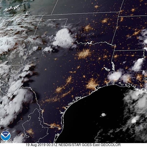
At 751PM, San Antonio was reporting a temperature of 94 with a dew point of 70. Clear skies covered eastern and downstate Texas, though the dry line was active on satellite in the western part of the state. Excessive heat advisories continue through the southern Plains, as high pressure has settled into the area. The anticyclonic flow is going to dissipate over the next 48 hours, with a return flow setting up along the Sabine River but not any further to the west. San Antonio looks to remain dry if uncomfortably warm to begin the workweek. Tomorrow – Mostly sunny, High 99, Low 78 Tuesday – Still hot, High 99, Low 79
TWC: Tomorrow – Partly cloudy skies High 99, Low 78 Tuesday – A few clouds from time to time. Continued very hot. High 99, Low 78
AW: Tomorrow – Mostly sunny; very warm High 100, Low 79 Tuesday – Mostly sunny; very warm High 101, Low 78
NWS: Tomorrow – Mostly sunny and hot, High 100, Low 79 Tuesday – Mostly sunny and hot, High 100, Low 78
WB: Tomorrow – Mostly cloudy in the morning, then clearing. High 98, Low 79 Tuesday – Partly cloudy. High 97, Low 78
WN: Tomorrow – Partly cloudy, High 100, Low 79 Tuesday – Partly cloudy, High 100, Low 78
FIO: Tomorrow – Humid and partly cloudy throughout the day. High 98, Low 79 Tuesday – Humid and partly cloudy throughout the day. High 99, Low 78
Here is the satellite, with some puffs developing in west Texas.