Back in Mid February, Greensboro was in the midst of a comfortable stretch of weather, at odds with what the calendar said. On the 20th and 21st, the weather was at the very least interesting. On the 20th, a splash of rain and a cold front meant temperatures were able only to reach 60 degrees. After that frontal passage, the high jumped to 73 on the 21st. Those highs and lows were both as low as (20th) and higher than (21st) all of the forecast highs. As it worked out, Clime was able to navigate their first forecast win, owing their victory to a dry forecast on the 21st. Actuals: February 20th, .03″ of rain, High 60, Low 44 February 21st, High 73, Low 47
Boy, we know when to pick these cross country trips. This trip, into the teeth of one of the most significant storms for the Upper Midwest in decades, will last 4 days in ideal conditions, though these will be less than ideal. It’s 2065 miles between the systems, and right now is prognosticated to have a pace of 66.6mph, which will lead to a perhaps aspirational 533 miles a day. Day 4 will be a hair shorter than the rest, but they are all going to feel long, I reckon.
DAY ONE (Tuesday)
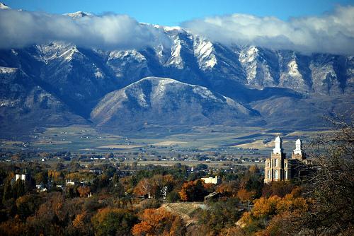
Logan, Utah
The entirety of our route on Tuesday will be in a at least a winter storm warning, while some stretches of southern Wyoming are in a blizzard warning. I think the heaviest snow will be in Montana tomorrow, though we will be seeing snow around Logan as we set forth. Wind will be on the increase throughout the day, but we will probably be dry from time to time from Kemmerer to Rock Springs, then even more sparsely through the remainder of the state of Wyoming. Assuming we keep our pace, we will be just ahead of the worst of the snow, but any flurries we see will be wind driven and challenging. The day will end in Sidney, in the Nebraska Panhandle. Batten down the hatches, it is going to be a long night.
DAY TWO (Wednesday) This is definitely our most imagination driven day. The heavier snow is going to sink south into Nebraska, along with a cold frontal wind, and it is not out of the question that blizzard conditions will grip most of I-80 in Nebraska. If that’s the case, then the road might simply be closed. The nasty parts of the storm will be cut off by a dry slot nosing north into the Omaha and Nebraska City regions, and we might even get some dry air after we leave the freeway in Lincoln. Expect to see drier condition as we head south, west of a cold front that will, by this point, have advanced into Iowa and Missouri. We will end the day in Kansas City, and be extremely grateful for it.
DAY THREE (Thursday) The nasty storm is going to focus it’s wrath to our north by Thursday, which is good news for our travels, bad news for the Great Lakes. South winds will be rushing north to meet that area of low pressure, and especially east of St. Louis, we will need both hands on the steering wheel, as if they haven’t been white knuckling the whole way already. We’ll make it to Simpsonville, east of Louisville, by the end of this day.
DAY FOUR (Friday) Low pressure will be moving vaguely poleward by the end of the week, and this is a relief for us. Dry skies will continue on the way to Greensboro, though a little band of light rain will develop eventually to our south and west, and that wind that will buffet us on Thursday will also be a memory. The arrival in Greensboro will come after 4 long days of driving, and will be quite a relief.
The winter track has not been kind to the low country of the Carolinas this year. It’s been quite dry and warm in the eastern Carolinas and a drought, not quite as severe as other parts of the country, has been building. Might we finally get a soaking of rain in North Carolina? Greensboro, in particular?
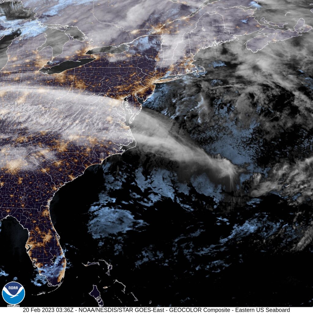
At 954PM, ET, Greensboro was reporting cloudy skies and a temperature of 48 degrees. Most of the Tar Heel State was reporting clear or fair skies, but Greensboro was under a high overcast. Greensboro’s observation reflects the satellite a bit more accurately, as a feather of clouds is seen extending from the Atlantic through Viginia and on to the Ohio Valley. This is extended from low pressure now headed for Greenland, and following a strong jet streak, running west to east through the region. Temperatures are expected to remain on the warm side in Greensboro to start the work week. A pulse moving through the northern Great Lakes will connect a warm front through a secondary trough moving behind the offshore front, and will touch off some mountain showers in Virginia and western North Carolina. More high overcast is anticipated in Greensboro on Monday afternoon. The real show will be massing in the High Plains. Warm air is going to start rushing north on Tuesday ahead of this feature, with temperatures beginning to rise, even among the layered clouds across the region. Tomorrow – mostly cloudy, High 65, Low 42 Tuesday – Mostly cloudy, High 71, Low 49
TWC: Tomorrow – Cloudy. Slight chance of a rain shower. High 64, Low 44 Tuesday -Partly cloudy, High 72, Low 51
AW: Tomorrow – Times of clouds and sun with a shower in places in the afternoon High 62, Low 45 Tuesday – Mostly cloudy; a shower cannot be ruled out High 70, Low 49
NWS: Tomorrow – A slight chance of rain after 1pm. Cloudy High 62, Low 44 Tuesday – A slight chance of rain. Partly sunny, High 71, Low 51
WB: Tomorrow – Cloudy, a slight chance of rain in the afternoon, High 60, Low 44 Tuesday – Partly sunny with a 20 percent chance of rain. High 71, Low 52
WN: Tomorrow – Mostly cloudy with isolated showers, High 62, Low 44 Tuesday – Partly cloudy, High 71, Low 51
CLI: Tomorrow – Light rain showers, High 61, Low 43 Tuesday – Partly cloudy, High 69, Low 48
I think with the lack of moisture in the area, the ongoing dry, and the warm temperatures, rain just doesn’t ring true to me as a worthwhile forecast. I’ll probably be wrong! Hope I am. Here is satellite, with that feather of clouds in the mid-Atlantic.
After a trip to Greensboro, let’s take a lengthy trip from Greensboro. It’s going to take us 3 1/2 days to location to location, and it will require a pace of 71.2mph to cover our 2065 miles, which is downright blistering. We’ll cover 569.7 miles on those first three days, leaving a little bit left over for the fourth day. Westward ho.
DAY ONE (Sunday)
Greensboro, North Carolina
I am quite taken with the rapid pace we will take as we get started off towards Tucson. We’ll alight through 4 different states as we begin, both Carolinas, Georgia and Alabama, where we will finish things off. High pressure is stout in the southeast, and we won’t have any weather concerns between Greensboro and Boligee, Alabama, where we are going to stop for the night.
DAY TWO (Monday) Low pressure is emerging from the southern Rockies this weekend, and will be a rainy little system moving through the Plains. The tail of the cold front will dangle into the Lower Mississippi Valley as we also scoot through that same part of the country. Shower activity will be possible from about Ruston, Louisiana west into the Piney Woods of Texas. It should be cloudy but dry west of about the Tyler area, which will take us into the Metroplex by evening. The day will end in Fort Worth.
DAY THREE (Tuesday) Leaving Fort Worth on Tuesday, we will enter the vast expanse of west Texas. It will be at it’s warm, dry and dusty best. There will be no well organized system across the region, but west Texas will indeed be squeezed between features, which will render the region cloudier than normal, but not quite rainy. We’ll make it as far as Tornillo, which isn’t quite to El Paso. Texas is very big.
DAY FOUR (Wednesday) The next round of wet weather for the desert Southwest, and there certainly aren’t many, usually, will be running into the area on Wednesday morning. There won’t be much rain east of Las Cruces, but there will be a few showers with some elevation wet snow for the entirety of our drive on Wednesday. When you go to Tucson, you probably don’t expect rain, but alas, that’s what we are going to find on this occasion.
The southern US has been trounced by severe weather lately, from the devastating tornadoes in Nashville and Cookeville, Tennessee, to persistent thunderstorms nearer the Gulf Coast. There is a break in the action, finally, across the region but will it last for our 2 day, 1219 mile route. Will these storms return, or will we be able to manage a steady pace (estimated at 66mph, with a goal of 529 miles in day one)?
DAY ONE (Saturday)
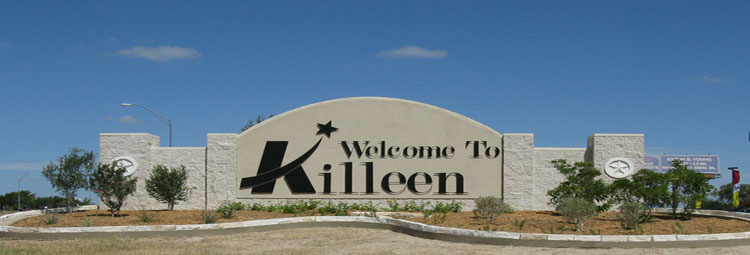
Killeen, TX
A split jet stream over the eastern US is coming together off shore in the Gulf Stream, meaning any and all concerning weather is going to be off shore this weekend. The primary concern between Killeen and Brandon, Mississippi, our destination for the night, will be ensuring that we remember our sunglasses and sunscreen in case we want to sit outside for dinner east of Jackson.
DAY TWO (Sunday) Brandon, Mississippi, is the home of the WFO for Jackson, and in my opinion is one of the best offices in the country. Too bad the weather is going to be so pleasant while we’re there. High pressure will only consolidate over the southeast, and the drive from Brandon to Greensboro will continue to be pleasant, though in the wake of the strong system now off shore, it might be a little cooler in Greensboro than anywhere else along our drive.
Usually, when you think of mountains, you think of snow capped peaks and chilly air. In Greensboro last week, they were directly responsible for temperatures not cooling off as quickly as it could have. cold air was rushing south from the Great Lakes, but got hung up in the mountains. Southerly flow with humid air produced clouds and a bit of rain that certainly allowed for a cooldown, but not quite on the order forecast by our model guidance for Friday. Weatherbug had a blend of a good temperature forecast, and were one of only three that had rain in the forecast on Thursday. Actuals: Thursday – .01 inches of rain, High 95, Low 72 Friday – .01 inches of rain, High 82, Low 72
The Carolinas were clipped by Dorian, with coastal sections of the states from Charleston to the Outer Banks sustaining damage, primarly due to storm surge and some isolated tornadoes, like the one in North Myrtle Beach. Greensboro was largely unaffected, and now can look instead to the west for their upcoming weather.
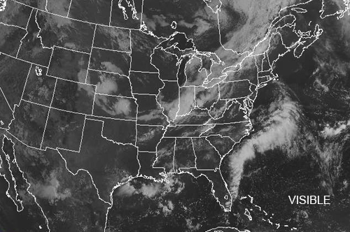
At 1152AM, ET, Greensboro was reporting a temperature of 79 degrees with fair skies. There was a little bit of cloud cover across the region, but not so much that the satellite was very busy. A stalled boundary suspended between two areas of low pressure in the Great Lakes was inducing a generally southerly flow, which will likely lead to low clouds and fog when temperatures start to wane. The western low will start to occlude, while the cold front attached to the boundary to the east will begin to sink further south, decoupling from the western low. There won’t be much energy with the tail of this front as it passes into North Carolina, but after sunset, destabilization aloft might lead to a few showers and storms on Friday evening. Tomorrow – Sunny and humid, High 92, Low 73 Friday – Mostly cloudy with increasing chances of rain. Cooler, High 83, Low 71
TWC: Tomorrow – Except for a few afternoon clouds, mainly sunny. high 95, Low 72 Friday – Scattered thunderstorms High 81, Low 71
AW: Tomorrow – Mostly sunny, hot, High 94, Low 71 Friday – Intervals of clouds and sun, a couple of showers and a thunderstorm, mainly later; warm High 83, low 72
NWS: Tomorrow – A slight chance of showers and thunderstorms after 2pm. Patchy fog before 9am. Otherwise, sunny, High 94, Low 71 Friday – A chance of showers and thunderstorms, mainly after 1pm. Increasing clouds, High 86, Low 70
WB: Tomorrow – Sunny. Patchy fog in the morning. A slight chance of showers and thunderstorms in the afternoon. High 93, Low 73 Friday – Partly sunny. A chance of showers and thunderstorms in the afternoon, High 83, Low 73
WN: Tomorrow – Partly cloudy with isolated storms, High 94, low 72 Friday – Partly cloudy with scattered storms, High 86, Low 70
FIO: Tomorrow – Humid and mostly cloudy throughout the day. High 93, Low 70 Friday – Humid and partly cloudy throughout the day. High 84, low 70
Model guidance suggests that temperatures will actually be in the high 70s on Friday, but note how nobody is on board with that. This is because guidance often fails to cope with terrain’s influence on temperature. That heavy, cold air will struggle to clear Appalachia, and with a blanket of mid level clouds, radiative cooling will be unlikely. Here is the satellite, with no clouds to speak of this morning.