In the wake of the same system that brought flurries that lingered for Sandusky, cold air spilled into Ohio Valley. Temperatures in Columbus, Indiana, for example, struggled to get out of the 20s on Friday, which meant all of our forecasts came in too warm. Things sorted themselves out a bit better on Saturday though, so the real tough spot was the first day. The Weather Channel had the best time of it on Friday, and that led to their victory for the day Actuals: Friday – High 28, Low 15 Saturday – High 36, Low 14
We’re taking a look at one of the three Columbuses we have in our system, and the only one that I’ve had the pleasure of passing through in person.
At 245PM, ET, Columbus was reporting a temperature of 19 degrees with clear skies and a steady west wind. High pressure was building into the area, however a weak wave riding the forward edge of this ridge brought a few flakes to the region through the overnight, and the accumulated inch or so may be helping keep temperatures a degree or two cooler. High pressure is going to remain in place for the next couple of days, building in from the west. While there is a weak thermal trough embedded in this ridge, it won’t be enough to slow down the warm up coming for Columbus this weekend. Expect a fairly pleasant weekend with sunny skies. Tomorrow – Mostly sunny, High 32, Low 10 Saturday – Mostly sunny, High 34, Low 17
TWC: Tomorrow – Sunshine and clouds mixed. Very cold High 32, Low 10 Saturday – Sunshine and clouds mixed. High 36, Low 14
AW: Tomorrow – Plenty of sunshine, but cold; a warmup is on the way High 33, Low 8 Saturday – Chilly with periods of clouds and sunshine High 38, Low 16
NWS: Tomorrow – Sunny, High 32, Low 9 Saturday – Mostly sunny High 35, Low 15
WB: Tomorrow – Mostly sunny, not as cold, High 26, Low 11 Saturday – Partly cloudy in the morning, then clearing, High 33, Low 16
WN: Tomorrow – Mostly sunny, High 31, Low 8 Saturday – Partly cloudy, High 34, Low 16
CLI: Tomorrow – Sunny, High 30, Low 9 Saturday – Sunny, High 35, Low 11
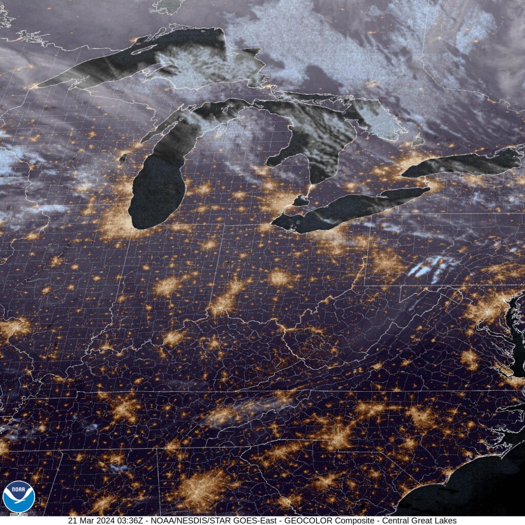
The Weather Channel says it’s going to be “very cold” tomorrow, while Weatherbug, with a cooler forecast, says “not as cold.” Perspective! Satellite shows some lingering clouds, and some lingering snow on the ground.
These East Coast trips are perhaps even more susceptible to inclement weather. The weather isn’t worse, but the travel is more urban, and a bit of rain can really tie things up. We’ll take two days, including longer day on Saturday, to get from southwest Georgia to southeast New Hampshire. It’s a 1,245 mile journey, taken at a 63.7mph pace. The first night day will end, theoretically, after about the 510 mile mark, leaving a monstrous second day of travel.
DAY ONE (Friday)
Columbus, Georgia
The remnants of Tropical Storm Gordon, which brought heavy rain to the Carolinas is now drifting northwestward along the Gulf Stream. The rotation wrought by the storm throughout he Eastern Seaboard is continuing to bring some clouds and spotty rain showers, especially in northern exposures of the Appalachians, and even as far south as the Smokey and Blue Ridge Mountains. Fortunately, this does not include Georgia, but there will be some drizzle and overcast in the Carolinas, leading to additional slowdowns through the Piedmont and Charlotte. Traffic will be thinner, but the spits and starts of rain will continue to Christianburg, the city at the Blacksburg exit in Virginia.
DAY TWO (Saturday)
I’ve got something from the good news department: Our route is not taking us through DC, Philadelphia or New York City. This is great, because it means we will avoid all the traffic brought upon by a stationary boundary setting up between the remnants of Gordon and a wave rippling through northern Ontario. We are likely to see rain in at least 4 states, starting around Winchester, Virginia, continuing through West Virginia and Maryland, and continuing to Pennsylvania. The rain will start to wind down as we approach Allentown. Even after that point, however, we will be arriving in the moisture rich environment in the wake of Gordon. While the more widespread rain will be behind us, especially as we hit Connecticut and Massachusetts, the chance for a spit of rain can’t be ruled out.
Last weekend, a system moved through the Great Lakes and eventually spiraled through the mid-Atlantic with a copious amount of rain falling around New York over the weekend. But we are here to talk about Columbus. In my forecast I noted that I thought Friday would be on the overcast side, and little did I know how thick those clouds would be. Temperatures were forecast to hit the low 60s on Friday, and they didn’t even get out of the mid-40s. I did say it would be warmer, and it was only 42 on Thursday! Ugh. There was a three way tie between The Weather Channel, Weather Service and Weathernation. Actuals: Thursday – High 41, Low 23 Friday – .19 inches of rain, High 45, Low 29
Back in the early days of this site, it seemed like we kept revisiting two cities in particular: Reno, Nevada and Columbus, Ohio. So I should do pretty well here!
At 1051PM, ET, Columbus was reporting fair skies with a temperature of 32 degrees. There is a brisk north wind rippling through central Ohio tonight, further exasperating a fire threat for parts of the region that missed out on the rain last week. The wind shouldn’t last too much longer, as surface high pressure is building into the Great Lakes for tomorrow. It will be cool with some, but nearly as much, wind. A clipper moving into the High Plains tonight will reach the Great Lakes in two days time. Ahead of that, expect a bump in temperatures on Friday with the warm front arriving in the area early in the day. Low pressure emerging in the Gulf will also be moving towards the mid-Atlantic Friday, and will attempt to marry the Clipper in the Great Lakes. This will manifest as some stratiform overcast with a bit of light rain into the evening hours. Colder air will wait for the weekend, with the heaviest precipitation also ducking Columbus both north and South. Tomorrow – Mostly sunny, High 42, Low 24 Friday – Warmer, with clouds and some light rain late, High 61, Low 26
TWC: Tomorrow – Sunshine and clouds mixed High 43, Low 23 Friday – Partly cloudy early followed by increasing clouds with showers developing later in the day. High 61, Low 28
AW: Tomorrow – Mostly sunny and chilly High 42, Low 22 Friday – Cloudy and warmer; a couple of afternoon showers High 64, Low 27
NWS: Tomorrow – Sunny, High 43, Low 23 Friday – A slight chance of rain after 3pm. Partly sunny, High 61, Low 28
WB: Tomorrow – Mostly sunny, High 41, Low 29 Friday – Partly cloudy. A chance of rain in the afternoon. High 60, Low 35
WN: Tomorrow – Mostly sunny, High 41, Low 25 Friday – Partly cloudy with light rain showers, High 61, Low 28
CLI: Tomorrow – Partly cloudy, High 41, Low 22 Friday – Rain Showers, High 61, Low 26
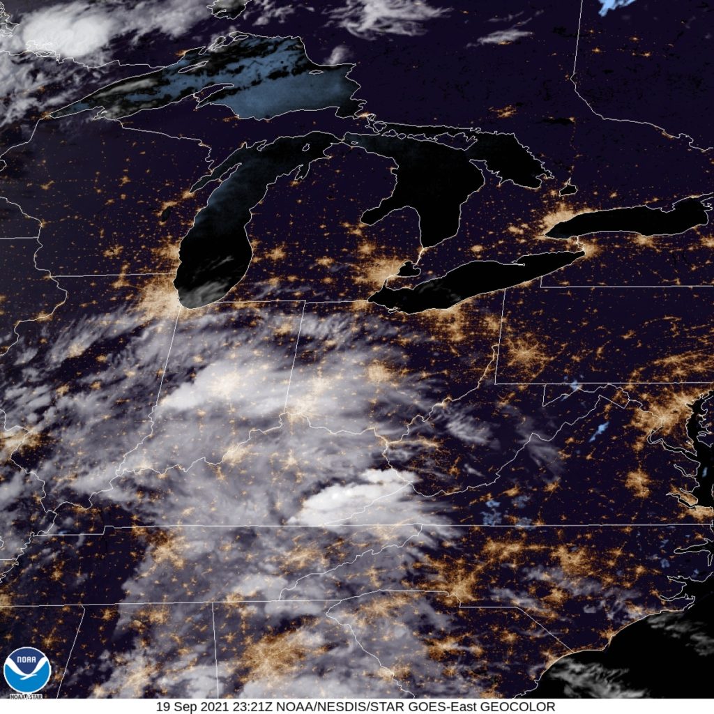
I’d be surprised if Friday was a super rainy day in Columbus, but I wouldn’t make outdoor plans. The satellite tonight sure is clear. A sign of how quickly things change.
We’re going to spend most of this 5 hour drive in Alabama, touching Montgomery and Mobile along the way. This pretty short drive will cover 327 miles at a pace of 64.1mph, which is also pretty reasonable for a short trip. All right, places to be, let’s go.
Columbus, Georgia
There is a strong area of low pressure in the Canadian Maritimes, and it is producing a cold front that is very active even in central Florida tonight. The boundary is reinforced by an area of low pressure emerging in the Gulf of Mexico. The increasing circulation will induce northerly winds in the southeastern US. While Florida will be particularly rainy, Alabama and it’s neighbors will be seasonably cool, with bright blue skies. It won’t even be humid in southern Mississippi when we arrive Sunday afternoon.
Just as summer turned to fall in Ohio, we forecast for Columbus. Wet weather was on it’s way into the Buckeye State, and was expected to bring a change to the pattern in central Ohio. Joke was on us, though, as that change came a day early. With rain and clouds, perhaps a bit thicker than expected, that change came a day early. Highs only reached 73 last Tuesday, thought they did get even cooler by mid week. All forecasters came through with a pretty workable forecast, with Weatherbug narrowly surpassing the rest. Actuals: Monday – .01 inches of light rain, High 81, Low 71 Tuesday – .24 inches of rain, High 73, Low 67
It’s time for a forecast in one of our oldest friends. Early in the site’s history we went to Columbus for our forecasts with stunning regularity. We should have a good handle on this, right?
At 851PM, ET, Columbus was reporting mostly cloudy skies with a temperature of 78 degrees. Much of the region is seeing clear skies, A strong, early autumn trough is rotating through the Upper Midwest, while the remnants of Nicholas bring quite a bit of rain to the southeast. Some of that rain fall and moisture is and will continue to be dragged north to the Ohio Valley. At present, there are a few scattered showers over Indiana and Eastern Kentucky, though nothing has filtered into Ohio yet. A strong ridge on the east coast will shift a bit eastward, helping to enhance the southerly flow towards Columbus, and making the threat of Nicholas related rainfall more likely on Monday. Fortunately, the storm and the attendant precipitation are weaker than they have been. The cold front will charge eastward and will arrive on Tuesday evening. Severe weather may not be the order of the day, but after the forecast period is through, expect a significant change to the weather when the front has passed by. Tomorrow – Scattered showers with isolated embedded storms, but mostly cloudy otherwise, High 83, Low 68 Tuesday – Rain, increasing late. cooler, High 78, Low 64
TWC: Tomorrow – Cloudy. A stray shower or thunderstorm is possible. High 84, Low 68 Tuesday -0 Rain showers in the morning with scattered thunderstorms arriving in the afternoon. high 78, Low 67
AW: Tomorrow – Mostly cloudy and warm; a thunderstorm in spots in the afternoon High 82, Low 67 Tuesday – Mostly cloudy with a stray thunderstorm in the afternoon High 77, Low 64
NWS: Tomorrow – A slight chance of showers before 10am, then a chance of showers after 1pm. Mostly cloudy, High 83, Low 68 Tuesday – Showers likely, then showers and possibly a thunderstorm after 2pm High 78, Low 68
WB: Tomorrow – Mostly cloudy, a slight chance of showers in the morning then a chance of showers in the afternoon, High 82, Low 70 Tuesday – Showers likely in the morning, then showers with a slight chance of thunderstorms in the afternoon, High 77, Low 69
WN: Tomorrow – Mostly cloudy with light rain showers, High 83, Low 68 Tuesday – Mostly cloudy with isolated showers and thunderstorms, High 78, Low 68
FIO: Tomorrow – Overcast throughout the day. High 84, Low 69 Tuesday – Light rain throughout the day. High 76, Low 66
I think wind is going to be a more significant issue than other outlets seem to, and it will be breezy every day. I think it will help force some gaps in the clouds, if nothing else. The clouds are coming already, though.
Before the entire planet went bananas, I had reached out to Kelly Greene, a meteorologist at WTHR in Indianapolis about putting together a feature forecast for Columbus, Indiana. She agreed to do so, but was about to take a vacation. and then came back, and despite everything, remembered our conversation. Truly impressive during these incredible times. It’s quite flattering! That’s enough out of me, the rest is all from Kelly.
A strong storm system moved over south central Indiana late day Thursday and Friday. Heavy rain in excess of 2″ to 3″ fell, with Columbus receiving close to 2″ of rain. Rivers will rise this weekend, including the Flatrock River and the East Fork White River in Columbus. Only minor flooding is expected. A cold front will bring in much colder air for the weekend, making it feel more like winter instead of the first weekend of spring! Temperatures will fall behind the front, eventually bottoming out into the upper 20s Saturday morning. Skies will be partly sunny by Saturday afternoon and the winds will relax. Afternoon highs will only climb into the low 40s Saturday afternoon, running more than 10 degrees below average. Sunday will be a bit warmer with increasing clouds. Temperatures will start off near 30° in the morning and will rebound into the mid 40s by afternoon. The next system arrives by mid afternoon, bringing more scattered showers Sunday afternoon into Monday morning. Spring-like temperatures return for the rest of the week.
Kelly Greene is a meteorologist at WTHR in Indianapolis and lives in Fishers, Indiana with her husband. Kelly actually lived in Columbus many years ago, and experienced many floods during that time. Kelly enjoys golf and travel and looks forward to being able to play 18 holes again soon.
Kelly can be found on social media at the following addresses