Heat index temperatures around metro Manila this week have been in the triple digits, and aren’t expected to drop in the near future. The thick, tropical air mass is expected to remain in place north of the ITCZ and south of the more active trade pattern, which is soaking south China but little else. Looking at the long range model outlook, there isn’t really a change in pattern either.
It will likely take a tropical wave moving through to kick up some seabreezes and move air around, though we are in the dry season for the Asian tropics. It’s never really cool in the Philippines, though, so bear that in mind when thinking about what kind of unbearable heat would lead to it being newsworthy.
It’s been a rough stretch for a large swath of the Plains. Will this weather be able to sneak eastward? Well not sneak, more like charge.
At 851ET, Muncie was reporting a temperature of 75 degrees with mostly sunny skies. There was a brisk south-southwest wind funneling the warm, moisture rich air northward within the warm sector of a strong system that has caused serious problems for the middle of the country. Fortunately, the associated cold front is occluded and significantly weaker by this point. Further, the boundary is anticipated to pass through Muncie overnight and into tomorrow morning. A perturbation along the boundary, the bit of energy bringing storms to Texas today, will slow the boundary down and some light rain will linger through most of the afternoon. While there is clear air behind the front, it will take too long to push out of Muncie to really change the pattern in town. Lingering overnight clouds from Monday into Tuesday will keep things mild overnight, and Tuesday will be sunnier than Monday, blunting any temperature downgrade even further. In fact, Tuesday may end up being warmer than Monday. Tomorrow – Mostly cloudy with scattered showers and an isolated thunderstorm. High 74, Low 62 Tuesday – Showers in the morning, High 76, Low 59
TWC: Tomorrow – Cloudy with occasional rain in the afternoon, High 77, Low 65 Tuesday – Cloudy skies early will become partly cloudy later in the day. High 74, Low 58
AW: Tomorrow – Breezy in the morning; cloudy with a couple of showers and a thunderstorm High 75, Low 65 Tuesday – Partly sunny, nice and warm High 76, Low 56
NWS: Tomorrow – A chance of showers, then showers likely and possibly a thunderstorm after 2pm. Mostly cloudy, High 75, Low 64 Tuesday – A 30 percent chance of showers, mainly before 8am. Mostly cloudy, High 72, Low 58
WB: Tomorrow – Partly cloudy with a chance of showers with a slight chance of thunderstorms in the morning. Then, mostly cloudy with showers likely with a chance of thunderstorms in the afternoon. high 72, Low 65 Tuesday – Partly cloudy with a chance of showers in the morning, then mostly sunny in the afternoon, High 70, Low 61
WN: Tomorrow – Partly cloudy with showers and a chance of storms, High 74, Low 63 Tuesday – Partly cloudy with light rain showers and isolated storms, High 72, Low 59
CLI: Tomorrow – Drizzle, High 75, Low 64 Tuesday – Drizzle, High 73, Low 59
It’s looking pretty clear in Muncie, and it looks like they are going to dodge the worst effects of this latest severe weather outbreak.
One thing that I have seen many people bring up this year is the spring freeze warnings. They come up after things start thawing out, but it’s not a straight line. Frost and freeze advisories are out for those early planters, or folks with sensitive plants that have started budding on their own. The Quad Cities WFO has a whole page for residents looking for more information on the subject, and forecasts of the same.
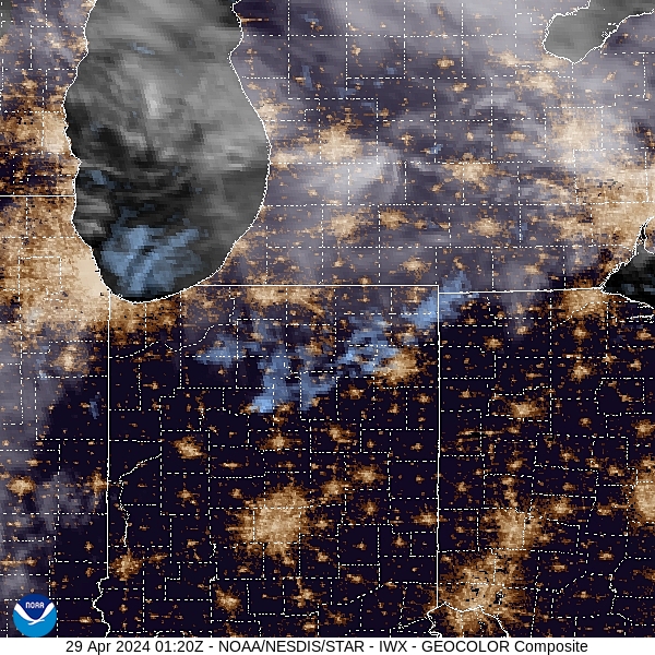
It has been a terrible weekend for a large chunk of the country. There were tornadoes most notably in Omaha, Lincoln and Des Moines on Friday, and on Saturday, the storms battered Oklahoma most notably. but also produced tornadoes from northwest Missouri to north Texas. Unfortunately, the tornadoes in Oklahoma led to one fatality, but throughout the storms, there was damage and lives upturned throughout the Plains.
Today features another enhanced risk of severe weather around the ArkLaTex. The next several days will still have a bit of a threat for severe weather, but it isn’t nearly on par with what we were concerned with through the weekend. Instead of a tornado outbreak, we’ll just see more of the garden variety thunderstorms. Strong, sure, but not historic.
When we looked at Chico earlier this month, it didn’t appear that there was much of a trend, but when we bore out the actual verification numbers, it turned out that yes, there was a trend. From the 16th to the 17th it got a bit warmer, both during the day and during the night. It isn’t crazy hot yet, but this little window into April was a sign that it’s coming. WeatherNation ended up getting the top forecast, all by themselves. Actuals: April 16th, High 75, Low 49 April 17th, High 77, Low 54
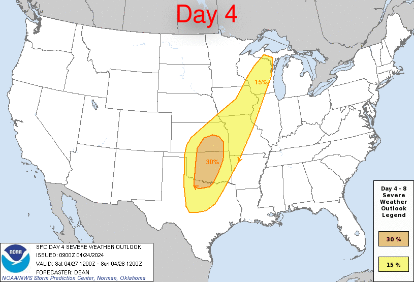
A tag team of systems moving through the country are going to bring quite a bit of severe activity through the weekend. It will be mostly in the Plains, and will start tomorrow with some significant storms possible, especially in the central Plains. The show will really get going over the weekend, though. Saturday looks like the more hectic day, as there is already a 30% outlook on Saturday, which is a long way out to think that there will be strong storms. Watch out in the highlighted areas.
It’s going to be a one day cross section of middle America. From northern Indiana to northwest Arkansas, we will take a long, 11+ hour day, covering 742 miles, for a pace of nearly 66mph. Indiana and Arkansas are closer than you think!
Elkhart, Indiana
A weakening system over the Great Lakes is getting drawn into the sphere of influence administered by a larger system trekking through the Gulf Stream. The weaker trailer is bringing some light rain to Elkhart tonight, but will be out of the picture by tomorrow morning. The feature is dangling a trough southward before it curls to the west, where it will lie stationary tomorrow. High pressure is building in over the north central US, but it won’t overpower the boundary and send it further south. Instead, the tail of the front will pass through the Ozarks, and while we will probably use our northern route to avoid any visibility issues, we will still enjoy them in their misty glory upon our arrival in Fayetteville.
It can be pretty muggy in south Texas, hotter than most of us northerners an even comprehend. A temperature of 83 degrees, though, is pretty palatable, even with some humidity. That’s where it sat in Victoria on the 14th and 15th if this month, an all together comfortable set of days in a part of the world that can be notoriously uncomfortable. It was a little uncomfortable as well for The Weather Channel, who won the day, but by a narrow margin. Actuals: April 14th, High 83, Low 63 April 15th, High 83, Low 70
I’m not happy. It’s about 40 degrees and windy, and generally, it’s colder than normal across the middle of the country. Matters were made worse when I spoke with someone in California who was talking about how warm it was today. Jokes on them, because this is the map for the 8-14 day outlook.

