Dangerous weather through the weekend

The weather has certainly been active this spring, and especially so if you consider how busy the Storm Prediction Center has remained since December of last year. Fortunately, since the devastation wrought in western Kentucky, southern Illinois and many places surrounding, we haven’t seen the type of devastation that stays in headlines for days.

That’s not to say the storms have been any less violent so far this year. In fact, there was an EF-4 tornado last month that swept through Winterset, Iowa, claiming the life of 6. That was as strong as the Mayfield, Kentucky tornado. The substantive difference is that Winterset is not as large a town as Mayfield, but the Winterset tornado also did not have as long a track as the western Kentucky storm.

A look at the tornado tracks this year show that, while there have indeed been many twisters this year, most of them were weak, and a lot of them were in Dixie Alley.

By Supportstorm – Own work, CC0, https://commons.wikimedia.org/w/index.php?curid=115162410

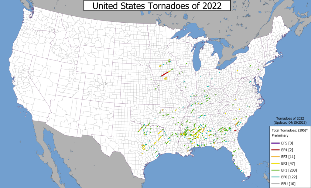
By and large, those storms are avoiding the largest population centers, and haven’t been particularly virulent, as tornadoes go.

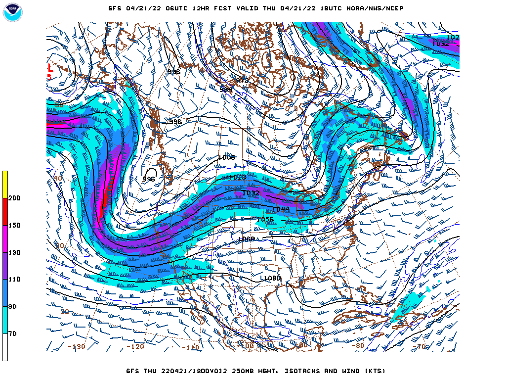
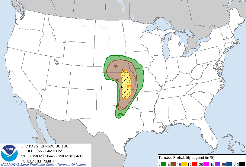
The pending change is twofold. First, tomorrow, the threat for significant weather targets an area including Tulsa and Wichita. Over the weekend, the threat includes the Dallas Fort Worth area. In general, the storms are going to affect a more populated area. Second, the storms are going to possess a notably higher threat for strong tornadoes. The hatched area in the SPC’s outlook for tomorrow indicates a threat of large (EF-2 or greater) tornadoes in an area. Those are big twisters dangerously close to Kansas City and Oklahoma City, potentially.

Big storms in more populated places remind us that we are definitely in severe weather season, and it is time to keep an extra eye on the sky.

Baltimore, Maryland to Racine, Wisconsin

Spring is supposed to be here. Really, it should be right around the corner. Why not drive to the lake? Specifically, this day and a half trip will cover the 776 miles between Chesapeake Bay and southeast Wisconsin. We will make the journey at a pace of 60.3mph. Thanks side streets and Chicago! The first day drive will cover 482 miles, leaving that Chicago chunk for day two.

DAY ONE (Thursday)

Baltimore, Maryland

The cold air in pursuit of an offshore cold front is going to cycle through New England and the mid-Atlantic tomorrow, likely pressing some mid and low level clouds through the undulating terrain of Pennsylvania. Light rain looks to be suppressed by local high pressure, and moisture is getting drawn towards a developing lee trough. Cloudy and cool, then, until we get to the toledo area and call it a night.

DAY TWO (Friday)

A warm front will be working it’s way north throughout the day on Friday, starting, I suppose, even on Thursday. Moisture will be penned closer to the Mississppi and the Illinois-Missouri border as we pass through Chicago, though a DEFCON 1 rain shower can’t be ruled out as we navigate the Windy City. It’s going to rain this weekend in Racine, but it probably won’t be when we arrive.

Baltimore, Maryland

I’ve been to Baltimore a couple of times. I saw Oriole Park and the Inner Harbor, and both were a joy. What about the weather, will that be as joyful?

At 1154PM, ET, Baltimore was reporting a temperature of 59 degrees. Clear or fair skies were reported across the mid-Atlantic, with a high amplitude ridge along the coast, merging, but not quite fully in phase, with a strong Bermuda High.
Seasonably strong storm features spun south of Newfoundland, and again over the Upper Midwest, and were connected by mid and high clouds in New England, showing off where the jet structure was strongest. The cold front with the trailing system will press eastward into the ridge, breaking down both the front and the ridge. Clouds will become more likely, as will some coastal haze, which will keep temperatures in check to start the work week.
Tomorrow – Sunny, High 77, Low 55
Monday – Clouds likely, High 70, Low 54

TWC: Tomorrow – Generally sunny High 80, Low 53
Monday – Mostly cloudy skies High 71, Low 54

AW: Tomorrow – Partial sunshine High 79, Low 54
Monday – Intervals of clouds and sun High 70, Low 54

NWS: Tomorrow – Patchy fog before 8am. Otherwise, mostly sunny, High 77, Low 53
Monday – Patchy fog before 11am. Otherwise, partly sunny High 70, Low 54

WB: Tomorrow – Mostly sunny, High 78, Low 53
Monday – Patchy fog in the morning, High 68, Low 53

WN: Tomorrow – Mostly sunny, High 77, Low 54
Monday – Partly cloudy High 70, Low 54

FIO: Tomorrow – Clear throughout the day. High 77, Low 51
Monday – Overcast throughout the day. High 70, Low 53

Head on over to WBAL to see friend of the Blog Tony Pann give the forecast for Baltimore, noting the wide variety of temperatures across Maryland tonight.

Nothing but clouds

A feature that got organized along the Gulf Coast last weekend threatened to bring some showers and storms as far north as Joplin, but alas, that was not the case. Well, sure, there were a few sprinkles on the 15th, even a rumble of thunder, but it wasn’t a washout, and that rain didn’t return on Saturday. There were plenty of clouds, though, and a little surge of cooler air, keeping temperatures below forecasts on every verifying period except the Friday low, in which the clouds kept things a bit warmer overnight. There was a tie at the top, between The Weather Channel and Accuweather.
Actuals: Friday, .05 inches of rain, High 69, Low 50
Saturday – High 60, Low 45

Grade: B-D

A sluggish, stormy spring

Everyone loves to talk about the weather, as I’m sure you do (you’re here at this site, after all) but depending on where you are this April, you might have a decidedly different conversation. If you are in the southern US, you are probably talking about how stormy this year has been. In the north, you probably can’t get over how chilly things have remained all spring.

For an explanation, we need to look even bigger than we usually do, beyond the confines of the Contiguous US. The answer lies in the jet structure across the United States. As you may already be aware, bigger features are more challenging to move in the atmosphere, and there is an enormous trough that keeps recycling and sustaining itself, and the base of that trough has run across the northern United States.

Take a look at the big picture, the jet forecast for this afternoon.

Typically, if I am looking at the US forecast, I would note the deep trough coming to the west coast was, or even noting the ripple in the northern Great Lakes, but when taking into account the spring writ large thus far, and unfortunately for the coming weeks, the immediate notice is that the larger waves are the ridges bracketing the United States.

There are semi-permanent features in the ocean, certainly, including the Bermuda High, and the existence of the ridges are not unusual. Some things that are factoring into making this spring unusual is the amplitude of the trough over North America. It should be starting to retreat into Canada, bringing some calm to the south, and allowing warmth to filter back north, but the mean trough is instead littered with localized troughs like the one set to upset this weekend.

Another peculiarity is how weak the trough in the Gulf of Alaska is. The Aleutian Low is as permanent s the Bermuda High, but right now, and for a while, this feature has been replaced by transient features moving into the Pacific Northwest. This gives this larger continental wave more breadth, and makes it more difficult to move.

With the mean trough over the US running through the northern tier of states, it is penning cold air that same swath of the country. On the same note, the sun is getting stronger, so warmth is building south of the jet. This clash of air masses at the surface, when coupled with the relatively shorter waves moving across the nation, is making for an active storm season, and a chilly spring, depending on what side of the divide you are on. Eventually, the pattern will break, but there isn’t an immediate sign of that happening quite yet.

Forecasters of the months

It’s been a slow start to the year, especially when it comes to reviewing our months of work. We have February and March to check in on, so let’s not waste time!

February was a very well contested month in the handful of forecasts we had. There was one outlet that lagged well behind, but we won’t embarrass them. Instead, we will point to Weatherbug, who had the solid victory in the month of February.

March was a little bit more snug at the top. Weatherbug was pipped in the end, with only half a point to spare. Good news on this tax day, as the National Weather Service took our tax dollars and turned it into a monthly W.

OutletForecast Wins (year)
National Weather Service3
Victoria-Weather2.33
Accuweather2.33
The Weather Channel1.33
Weatherbug1
Forecast.io
WeatherNation

Record breaking heat in San Francisco

An advancing system in the Pacific Northwest was poised to bring some changing wind conditions in northern California earlier this month, and along with those changing vectors, the temperature in San Francisco was poised to bounce around. It bounced much higher than expected on Thursday the 7th, hitting a record high of nearly 90. things were more reasonable on Friday, reaching the upper 60s and feeling a bit more San Franciscan. The Weather Service and Weathernation altered their forecasts a bit, but still managed to come together for a victory.
Actuals: April 7th, High 89, low 56
April 8th, High 69, Low 52

Grade: B-D

Anniston, Alabama to Joplin, Missouri

It’s time for another road trip. We’re just going to take one day to head from Alabama to Missouri, crossing the Mississippi River and trying to dodge rain drops. It’s a 659 mile journey that we will cover at a pace of about 64.3mph, which is slowed by Memphis and not spending as much time as we would like on arterial interstates.

Anniston, Alabama

High pressure will be in retreat over the southern US, but it will still be comfortably in place in northern Alabama and Mississippi tomorrow. Dry skies with mostly sunny conditions will guide us through Birmingham and Tupelo, but an organizing system in Louisiana will start to kick some clouds north by the time we reach Memphis. Don’t be surprised if there are a few spits of rain starting around Hardy, Arkansas, which may linger the rest of the way through the Missouri Ozarks. North of the highest terrain, from Springfield to Joplin, it should be a bit drier, but the chances for rain are certainly not going to be zero.

Joplin, Missouri

Joplin, Missouri

The tornado season has been off to a lively start. 2022 has already seen deadly tornadoes, most notably in Winterset, Iowa last month, but fortunately, we haven’t had any that were historic in their catastrophe. As we forecast in Joplin, however, it’s a reminder for all of us to be prepared, especially this time of year, and in this part of the country.

At 753AM, CT, Joplin was reporting clear skies and a temperature of 33 degrees. the late season cold, amid clear skies behind a strong cold front has lead to many frost and freeze advisories in western Missouri, northwest Arkansas, Kansas and Oklahoma. The large area of low pressure responsible for the adventuresome weather in the middle of the country this week is now parked over the Great Lakes. The only satellite evidence in the Plains is a few puffs of clouds from Rockford, Illinois to Topeka Kansas, which will likely not develop into anything, and will certainly leave Joplin alone.
Fortunately, with spring having arrived, the clear skies will mean a warming trend, even with the cold air mass presently in southwest Missouri. A deep trough lies over the northern US, fostering the strong feature referenced earlier, but another ridge is rising through the southern Rockies. By Friday evening, convergence area of the two jets will become active with showers and isolated storms, with low pressure developing in the Lower Mississippi Valley. This will be primarily flow driven, rather than air mass driven, so cold air is not going to arrive in Joplin on Saturday. Because of that, the northwest flank of the storm will still feature a little bit of convection, intermittently on Saturday.
Tomorrow – Increasing clouds, with an isolated shower. Chances increasing late. High 71, Low 45
Saturday – Showers with isolated thunderstorms, mostly cloudy, High 64, Low 48

TWC: Tomorrow – Rain showers in the morning with scattered thunderstorms arriving in the afternoon. High 73, Low 50
Saturday – Sunshine and clouds mixed. High 63, Low 47

AW: Tomorrow – Breezy in the morning; otherwise, cloudy with a shower in spots in the afternoon High 70, Low 49
Saturday – Mostly cloudy and breezy with a passing shower High 63, low 47

NWS: Tomorrow – A 30 percent chance of showers and thunderstorms after 8am. Mostly cloudy, High 72, low 49
Saturday – Mostly sunny (early rain), High 61, Low 40

WB: Tomorrow – Breezy. Mostly cloudy with a 30 percent chance of showers and thunderstorms, High 68, low 49
Saturday – Cooler. Partly cloudy. A 20 percent chance of showers in the morning, High 62, Low 50

WN: Tomorrow – Mostly cloudy, High 72, Low 36
Saturday – Partly cloudy with light rain showers, High 61, Low 46

FIO: Tomorrow – Overcast throughout the day. High 72, Low 48
Saturday – Possible light rain in the morning High 62, Low 47

Weathernation is going far afield from the rest of the outlets. I had to recheck their low temperature multiple times. Satellite is pretty clear, except for that band of clouds I noted.