
Do you know what county you are in? You probably know what county you live in. but do you know what county you work in? Let’s say you do know that information: Do you know the name of the county just to you west? Or in any other direction?
Compounding that even further, do you travel? For work or for pleasure. If so, can you find where you are, generally, on a map? GPS is great for getting us places, but for some people, it has made map reading extremely difficult, as for most, it isn’t a muscle that often needs to be flexed.
There is one area that counties and geolocation are important. The NWS still issues watches and warnings based on counties. Radar only shows the largest locations, and even then, the scale isn’t always perfect. Or if you are traveling, say, to the Dallas area, would you realize as you are in Grapevine that you are north of Fort Worth?
This is the current radar from West Texas, simply because it is the only site with severe weather tonight.
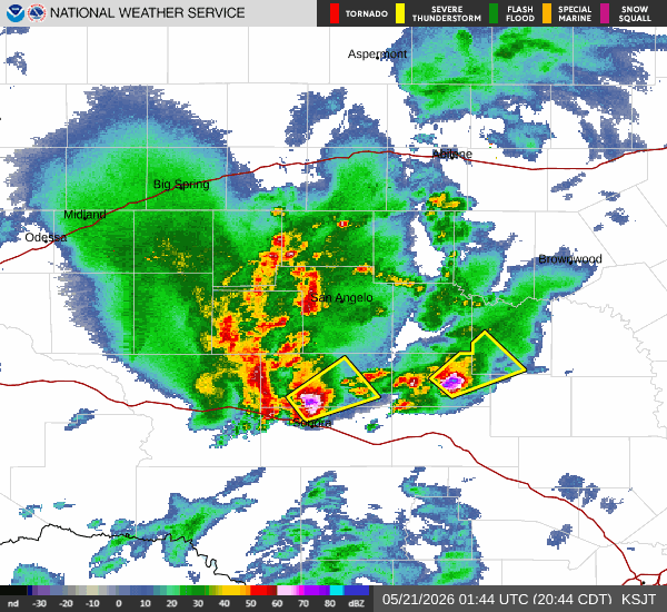
The yellow boxes represent severe thunderstorm warnings. Here is the text on one of those warnings:
...A SEVERE THUNDERSTORM WARNING REMAINS IN EFFECT UNTIL 1015 PM CDT
FOR SOUTHWESTERN MCCULLOCH...NORTHEASTERN MENARD AND NORTHWESTERN
MASON COUNTIES...

At 922 PM CDT, a severe thunderstorm was located over Us-
190 Near The Menard-
Mcculloch County Line, or near Calf Creek, moving northeast at 20
mph.

HAZARD...60 mph wind gusts and half dollar size hail.

SOURCE...Radar indicated.

IMPACT...Hail damage to vehicles is expected. Expect wind damage to
         roofs, siding, and trees.

This severe storm will be near...
  Calf Creek around 930 PM CDT.

Other locations impacted by this severe thunderstorm include The
Intersection Of Us-190 And Ranch Road 1311 and Us-
190 Near The Menard-Mcculloch County Line.

PRECAUTIONARY/PREPAREDNESS ACTIONS...

For your protection move to an interior room on the lowest floor of a
building.
You, I assume, are like me, and wouldn’t know which warning that was for, had I not just clicked on it. It wouldn’t mean much to me if I was in West Texas. In this scenario, let’s say I had heard of Calf Creek, because I was nearby in Eden. Would I know, based on the polygon that the storm was coming for me? Of if I was in Junction, would I know that it wasn’t?
One thing that meteorologists always tell you when there are forecasts for severe weather is to be prepared. Especially when you are away from home, take the time to figure out where you are on the map. If the forecast looks dicey, learn what county you are in, and even what part of the county, if you can. Victoria, for example, is in Carver County, Minnesota, and on the east side, near the border with Hennepin County. To the west, northwest and southwest are McLeod, Wright and Sibley Counties. Even when not eyeballing the radar myself, if I heard on the radio or saw an alert on TV for one of those counties, I should start to pay closer attention.
I’m a map nerd, certainly, and a lot of this comes to me naturally. That said, the weather warning apparatus necessarily makes assumptions about YOUR ability to read a map and know where you are. Take the time to hone those skills.