The forecast in Denver followed our misadventures in Fort Collins. The pattern was a little less thorny than the one in Fort Collins, but the tricks of geography remained, and the weather wasn’t about to be perfect. Did we do any better with this one? Yes! I would say we did! Clime even hit on the precipitation forecast, which was better than anyone else could say. The key to success was to be more pessimistic about the 5th, and optimistic about the 6th, which was not how most anyone went, rewarding the outlets that saw a brighter future. The top grade was still a C, which isn’t great, but it IS better than anything we saw in Fort Collins. I’ll take the win! Well, Clime will take the win, I just mean I appreciate the improvement. Actuals: 9/5 – .01 inches for rain, HIgh 64, Low 51 9/6 – High 82, Low 46
We’ve managed a few trips to Colorado recently. The weather is always interesting there, so I have no complaints. How does the end of the week look in the Mile High City?
At 253PM, MT, Denver was reporting a temperature of 84 degrees and partly cloudy skies. A westerly flow in the Rockies was producing a few showers in the higher terrain, but a dew point of 38 dried everything out before it could reach the ground in town. High pressure is moving southward along the Front Range, and should lead to a fairly decent time on Friday. An area of low pressure in the Great Lakes is tailing a cold front into the southern part of the state, where a few showers are found. A jet trough will dive through the Prairies over the next couple of days, with a brisk westerly flow across the Rockies into the trough. This will lead to locally warm flow and an inversion at the surface. This could make Saturday a bit on the grey/grimy side. Tomorrow – Mostly cloudy, High 68, Low 54 Saturday – Hazy and smoky, but warmer, High 79, Low 48
TWC: Tomorrow – Cloudy skies early, followed by partial clearing. High 72, Low 56 Saturday – Generally sunny despite a few afternoon clouds. High 82, Low 52
AW: Tomorrow – Nice with sun and areas of high clouds High 72, Low 55 Saturday – Mainly cloudy High 81, Low 49
NWS- Partly sunny High 73, Low 54 Saturday – A slight chance of showers between noon and 3pm, then a slight chance of showers and thunderstorms after 3pm. Increasing clouds, High 80, Low 50
WB – Tomorrow – Mostly cloudy in the morning then partly cloudy with a slight chance of thunderstorms in the afternoon, High 73, Low 61 Saturday – Mostly sunny with a 10 percent chance of showers. High 81, Low 54
WN – Tomorrow – Partly cloudy, High 72, Low 55 Saturday – Partly cloudy with isolated showers and isolated storms, High 80, Low 50
CLI: Tomorrow – Light rain showers, High 70, Low 52 Saturday – Partly cloudy, High 80, Low 49
Well, this precipitation forecast got more interesting than I anticipated. It will be interesting to see how it turns out. I expect a lot of it will revolve around drizzle within the mist in the early mornings, rather than the stuff we see in the Plains tonight.
On June 9th, we put together a forecast for Denver. If you know anything about the city, you know that the airport is well to the east of town in the vast prarieland of the eastern part of the state. It’s otherwise barren country. Further west are the Rockies and the front range. Generally speaking, it’s a little bit cooler in the city than at the airport because of the terrain. A bit of a reverse urban heat island. This is all important background for the realization that downtown Denver, which is where the forecast verified, is different by a few degrees than the airport, which is the best source for model output statistics. So, we forecast, we went uphill and we verified. Clime, what with the algorithms and had the top temperature forecast, but their erroneuous rain forecast on the morning of the 10th meant Victoria-Weather and The Weather Channel claimed a share of the win as well. Monday July 10th, High 89, Low 60 Tuesday – July 11th, Hgh 92, Low 64
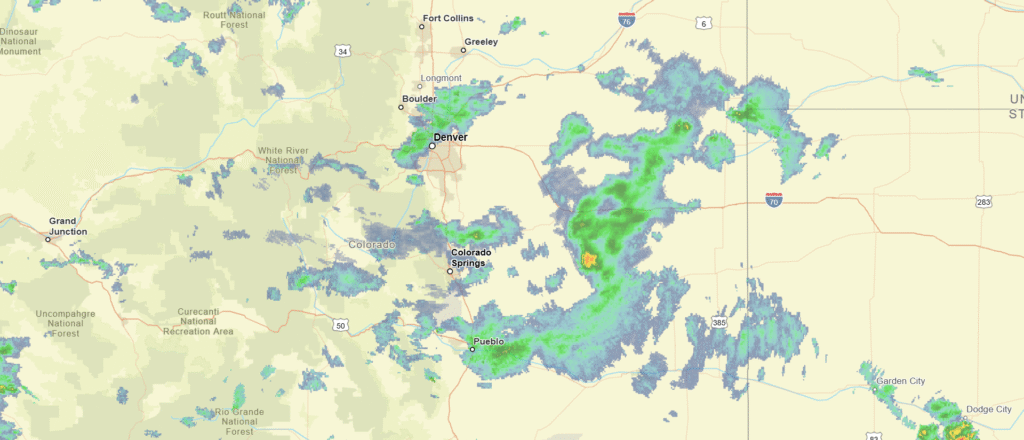
Denver is typically at the border between two worlds, one mountainous, the other empty plains. Lately, they have also been along an oscillating lee trough, touching off strong thunderstorms throughout the area.
At 853PM, MT, Denver was reporting a temperature of 70 degrees with fair skies. Thunderstorm activity has finally started to leave eastern Colorado and western Kansas in piece, as a weak upper level ridge has settled in place over the central Rockies. For the next couple of days, the primary factor in the ignition of showers and storms will be a dry line that will initially be too far south to bring any wet weather to the Mile High City, and shift east into the Plains. Denver will continue to warm and dry out as the week begins. Tomorrow – Mostly sunny, Hot, High 91, Low 61 Tuesday – Mostly sunny and even warmer, High 97, Low 63
TWC: Tomorrow – Sunshine and clouds mixed High 91, Low 61 Tuesday – Sunshine and some clouds. Hot. High 97, Low 63
AW: Tomorrow – Mostly sunny High 91, Low 58 Tuesday – Very warm with plenty of sunshine High 97, Low 61
NWS: Tomorrow – Very warm with plenty of sunshine High 95, Low 60 Tuesday – Sunny High 95, Low 62
WB: Tomorrow – Partly cloudy, a 10 percent chance of thunderstorms in the afternoon, High 92, Low 61 Tuesday – Mostly sunny, High 96, Low 61
WN: Tomorrow – Partly cloudy, High 95, Low 60 Tuesday – Mostly sunny, High 95, Low 62
CLI: Tomorrow – Light Rain Showers, High 87, Low 61 Tuesday – Sunny, High 94, Low 62
Clime looks to be on a slightly different planet than the rest of the forecasters her. In fact, I would say if this forecasts busts, it will be because the temperature is even warmer tomorrow. Satellite tonight is awfully quiet.
OK, we’ve been sitting on this verification for a while. When you see how bad everyone did, you’ll think it was a stall tactic, but really, I’ve just been really busy. Denver is a tricky place to forecast for, and they pulled out all the stops during the last weekend of April. After a rain soaked Friday, Saturday dodged all the rain drops, and the clear morning skies meant the morning low was significantly colder than we bargained for. And then Sunday, it did rain a little bit. Strangely, that rain came with a significant warm up that outclassed meteorologist’s wildest dreams. All told, Victoria-Weather and Accuweather backed into a tie for the top forecast, but it will probably go down as the worst of the first half of he year, at least. Actuals: Saturday (26th) – Hgh 67, Low 39 Sunday (27th) – Rain reported, not measured, High 78, Low 41
We are about as close to mountains at the start and end of this trip as we can get, but yet we will only spend a quick moment in eastern Tennessee contending with elevation changes. We’ll maintain a pace of nearly 70mph as a result, and cover 553 miles per each of the first two days, but leave a little more than half a day to get through the high country on Monday. The Plains are getting active. Is any chasing in order?
Denver, Colorado
DAY ONE (Saturday) It’s become so active across the country that some systems are becoming unable to find a full wealth of energy and really get going. so it will be on Saturday as we drive the vast expanses of Kansas. There will be a front snaking through Nebraska and western Kansas, but it won’t be doing much, except producing a few gentle rolling clouds, and maybe…. maaaaybe a dry thunderstorm or light rain shower. The bulk of the moisture is going to be in the southeast, unable to reach the front attached to a low moving along the Canadian border. It will get even more serene as the day continues, and our day will end in Lawrence.
DAY TWO (Sunday) A cold front will be sagging towards eastern Kansas by Sunday morning, but this is the rare case where heating of the day will actually serve to stabilize the region, and we should leave Lawrence with showers diminishing to the west. Tentative high pressure will set up between this fading band of showers and the retreating area of rain and thudnerstorms in the southeast. As a result, we will bisect Missouri, clip Illinois and Kentucky and reach Clarksville, Tennessee without much of a threat of rain.
DAY THREE (Monday) I’m not sure you could ask for a better day to drive through Tennessee than next Monday. Temperatures won’t swelter, and the sun will be out. We’ll snake into Athens with only a few clouds in the sky, temperatures comfortable and a few hours to spare left in the afternoon.
Everyone everywhere says “if you don’t like the weather here, wait for 15 minutes” or something like that. Denver, though, is perhaps the most variable city in the country and we get to forecast for it! Joy.
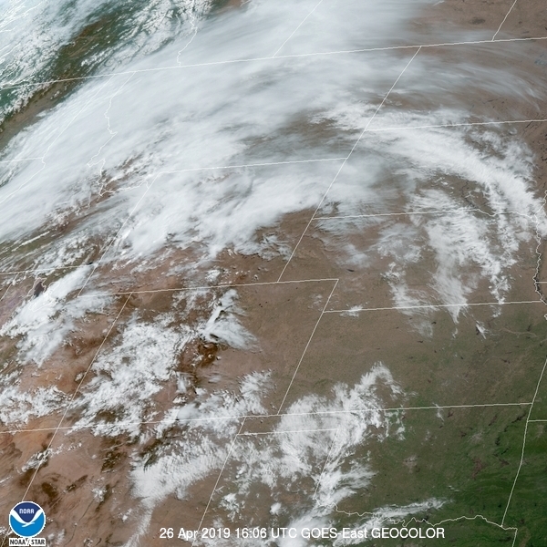
At 1005AM, MT, Denver was reporting clear skies and a temperature of 59 degrees. These conditions belied an increasingly active p, Low attern in the northern Rockies, as a deepening trough is going to bring some precipitation to the higher terrains this afternoon and evening. It is a shallow amplitude feature and will sweep through the region quickly. There may be a splash of precipitation on Saturday morning. The jet stream at this moment is shaped like a w, and the second lobe will strafe the northern Rockies on Sunday. As the trough emerges in the northern Plains, surface low pressure will develop, with a cold front tailed into the Denver region. This is he most likely time for the area to see wet weather this weekend, with a few afternoon thunderstorms, particularly east of town, a strong possibility. Tomorrow – A bit of morning drizzle, then clearing, High 69, Low 47 Sunday – Late rain and thunderstorms, High 71, Low 42 (late)
TWC: Tomorrow – Sunshine and some clouds. A stray shower or thunderstorm is possible. High 72, Low 48 Sunday – A mix of clouds and sun early, then becoming cloudy later in the day. A stray shower or thunderstorm is possible. High 74, Low 51
AW: Tomorrow – sunshine and some clouds; comfortable High 70, Low 47 Sunday – Times of clouds and sun, a thunderstorm around in the afternoon High 72, Low 44
NWS: Tomorrow – Mostly sunny High 72, Low 49 Sunday – A 20 percent chance of showers and thunderstorms after noon. Partly sunny, High 73, Low 49
WB: Tomorrow – Partly Cloudy (late rain), High 69, Low 49 Sunday – Mostly cloudy with a 20 percent chance of thunderstorms, High 70 Low 47
WN: Tomorrow – Mostly sunny, High 72, Low 49 Sunday – Partly cloudy with isolated storms, High 73, Low 49
FIO: Tomorrow – Partly cloudy until morning. High 72, Low 49 Sunday – Partly cloudy starting overnight. High 77, Low 51
As is only fitting with Denver these forecasts are all over the map.